Owners Manual
Page 4
... 17 Editing or Deleting a Proximity Alarm 17 Setting the Proximity Alarm Tones 17 Disabling All Proximity Alarms 17 Satellite Page 17 GPS Satellite Settings 17 Sending and Receiving Data Wirelessly 18 Using the VIRB Remote 18 Customizing the Device 18 Custom Data Fields and ... 21 Time Settings 21 Accessibility Settings 21 Profiles 21 Resetting Data and Settings 21 Device Information 22 Product Updates 22 Setting Up Garmin Express 22 Getting More Information 22 Viewing E-label Regulatory and Compliance Information ........ 22 Installing AA Batteries 22 Device Care 22 Cleaning...
... 17 Editing or Deleting a Proximity Alarm 17 Setting the Proximity Alarm Tones 17 Disabling All Proximity Alarms 17 Satellite Page 17 GPS Satellite Settings 17 Sending and Receiving Data Wirelessly 18 Using the VIRB Remote 18 Customizing the Device 18 Custom Data Fields and ... 21 Time Settings 21 Accessibility Settings 21 Profiles 21 Resetting Data and Settings 21 Device Information 22 Product Updates 22 Setting Up Garmin Express 22 Getting More Information 22 Viewing E-label Regulatory and Compliance Information ........ 22 Installing AA Batteries 22 Device Care 22 Cleaning...
Owners Manual
Page 6
... power is low. 1 Press to open area. 2 If necessary, turn off . NOTE: It may take up to 20 minutes to activate your Montana 700i/ 750i device, you go outdoors. 5 Go outdoors to an open the status page. flashes while the device determines your path as marking waypoints,... it acquires satellite signals. After storage, you should charge the battery to at explore.garmin.com. 2 Turn on the device. 3 Select Next. 4 Follow the on-screen instructions. Status Icons ANT+® sensor status GPS signal strength Charging battery 2 Introduction Press or swipe down from the top of the ...
... power is low. 1 Press to open area. 2 If necessary, turn off . NOTE: It may take up to 20 minutes to activate your Montana 700i/ 750i device, you go outdoors. 5 Go outdoors to an open the status page. flashes while the device determines your path as marking waypoints,... it acquires satellite signals. After storage, you should charge the battery to at explore.garmin.com. 2 Turn on the device. 3 Select Next. 4 Follow the on-screen instructions. Status Icons ANT+® sensor status GPS signal strength Charging battery 2 Introduction Press or swipe down from the top of the ...
Owners Manual
Page 10
... the altimeter, select . Altimeter Settings From the altimeter, select > Altimeter Setup. Auto Calibration: Once allows the altimeter to automatically calibrate one time when you to a GPS compass when you are watching for pressure fronts. 6 Viewing the Main Pages Heading Setup: Allows you start an activity. Lock Data Fields: Locks the data...
... the altimeter, select . Altimeter Settings From the altimeter, select > Altimeter Setup. Auto Calibration: Once allows the altimeter to automatically calibrate one time when you to a GPS compass when you are watching for pressure fronts. 6 Viewing the Main Pages Heading Setup: Allows you start an activity. Lock Data Fields: Locks the data...
Owners Manual
Page 11
... to manage notifications that appear on your compatible smartphone to be paired with widgets, data fields, and apps using the Garmin Connect app. You can use your Montana device. Managing Notifications You can hide notifications so they do not appear on your compatible smartphone. 1 Select > Notifications.... to view live data on your phone receives messages, it takes to get an initial GPS fix using email or social media, allowing them an inReach message from the Garmin Connect app, select Settings > Smart Notifications. You can view notifications, you to download an...
... to manage notifications that appear on your compatible smartphone to be paired with widgets, data fields, and apps using the Garmin Connect app. You can use your Montana device. Managing Notifications You can hide notifications so they do not appear on your compatible smartphone. 1 Select > Notifications.... to view live data on your phone receives messages, it takes to get an initial GPS fix using email or social media, allowing them an inReach message from the Garmin Connect app, select Settings > Smart Notifications. You can view notifications, you to download an...
Owners Manual
Page 13
...or where you are locations you enter an area with the device, such as restaurants or marine services. When averaging, the device takes several GPS readings at the same location and uses the average value to provide more accuracy. 1 Select Waypoint Manager. 2 Select a waypoint. 3 Select...Select Mark Waypoint. 2 If necessary, select a field to the waypoint location. 5 Select Start. 6 Follow the on the map. • Select Sort to buy.garmin.com or contact your device. 1 From the map, select > Map Setup > Configure Maps. 2 Select the toggle switch to Route. 4 Select a route. Editing ...
...or where you are locations you enter an area with the device, such as restaurants or marine services. When averaging, the device takes several GPS readings at the same location and uses the average value to provide more accuracy. 1 Select Waypoint Manager. 2 Select a waypoint. 3 Select...Select Mark Waypoint. 2 If necessary, select a field to the waypoint location. 5 Select Start. 6 Follow the on the map. • Select Sort to buy.garmin.com or contact your device. 1 From the map, select > Map Setup > Configure Maps. 2 Select the toggle switch to Route. 4 Select a route. Editing ...
Owners Manual
Page 16
... a Saved Activity You can receive weather forecasts for your current location, a waypoint, GPS coordinates, or a location you choose on the map. inReach Weather: Your Montana 700i/750i can switch the start and end points of your smartphone or to request ...forecast incurs the same data charges or additional charges as requesting a forecast. 1 Select inReach > inReach Weather. 2 Select a location with other compatible Garmin devices. 1 Select Recorded Activities. 2 Select an activity. 3 Select > Save as Waypoint. Marine forecasts are not available for your current location....
... a Saved Activity You can receive weather forecasts for your current location, a waypoint, GPS coordinates, or a location you choose on the map. inReach Weather: Your Montana 700i/750i can switch the start and end points of your smartphone or to request ...forecast incurs the same data charges or additional charges as requesting a forecast. 1 Select inReach > inReach Weather. 2 Select a location with other compatible Garmin devices. 1 Select Recorded Activities. 2 Select an activity. 3 Select > Save as Waypoint. Marine forecasts are not available for your current location....
Owners Manual
Page 17
..., or marine weather forecasts using the device, you can quickly switch between forecasts for waypoints, GPS coordinates, or other locations. 1 While viewing an active weather forecast, select > Manage Locations ...forecast, select > Manage Locations. 2 Select a location from the BaseCamp™ application (Garmin Adventures, page 14). Alarm Clock: Sets an audible alarm. Area Calculation: Allows you ...NOTE: inReach features are available only on the Montana 700 device. NOTE: The inReach Remote feature is available only on the Montana 700i/750i device. Mark Waypoint: Saves your...
..., or marine weather forecasts using the device, you can quickly switch between forecasts for waypoints, GPS coordinates, or other locations. 1 While viewing an active weather forecast, select > Manage Locations ...forecast, select > Manage Locations. 2 Select a location from the BaseCamp™ application (Garmin Adventures, page 14). Alarm Clock: Sets an audible alarm. Area Calculation: Allows you ...NOTE: inReach features are available only on the Montana 700 device. NOTE: The inReach Remote feature is available only on the Montana 700i/750i device. Mark Waypoint: Saves your...
Owners Manual
Page 18
... start an adventure, you can select it to My Collection or to refine a waypoint location for your GPS position. When you have a VIRB® camera paired with the moon phase, based on the Montana 700i/750i device. The alarm sounds at an object in the main menu, and drag it to to... add this application to set the time. 3 Select Start Timer. If the device is off at the alarm time, the device turns on the Montana 700i/750i device. Garmin Adventures You can select it (Customizing the Main Menu, page 14). 2 Select and to the main menu before you can group related items...
... start an adventure, you can select it to My Collection or to refine a waypoint location for your GPS position. When you have a VIRB® camera paired with the moon phase, based on the Montana 700i/750i device. The alarm sounds at an object in the main menu, and drag it to to... add this application to set the time. 3 Select Start Timer. If the device is off at the alarm time, the device turns on the Montana 700i/750i device. Garmin Adventures You can select it (Customizing the Main Menu, page 14). 2 Select and to the main menu before you can group related items...
Owners Manual
Page 19
... activation code appears. 3 Follow the on the object inside of your device has enough available storage space for hidden caches using clues and GPS coordinates. A white frame appears on your dogs, view their current status and location, and view their distance from which players hide or ... you do not want to your device, you must enable broadcasting on the map. 3 Select Go to navigate to the Garmin Connect app (Pairing a Smartphone with your Montana 750i device. If enabled, the geographic location is in the downloaded imagery files, select Radius, and enter a distance from...
... activation code appears. 3 Follow the on the object inside of your device has enough available storage space for hidden caches using clues and GPS coordinates. A white frame appears on your dogs, view their current status and location, and view their distance from which players hide or ... you do not want to your device, you must enable broadcasting on the map. 3 Select Go to navigate to the Garmin Connect app (Pairing a Smartphone with your Montana 750i device. If enabled, the geographic location is in the downloaded imagery files, select Radius, and enter a distance from...
Owners Manual
Page 21
chirp A chirp is a small Garmin accessory that contains a chirp, details about the chirp appear. 2 Select Show...left in the geocache list. By default, the route appears as a magenta line. 2 Navigate using your Montana 700 device, select inReach Remote. Setting the Proximity Alarm Tones You can use this application to the main menu...Customizing the Main Menu, page 14). 3 If necessary, select Yes. 4 Wait while the Montana 700 device connects to your current location, GPS accuracy, satellite locations, and signal strength. Setting a Proximity Alarm Proximity alarms alert you when you to...
chirp A chirp is a small Garmin accessory that contains a chirp, details about the chirp appear. 2 Select Show...left in the geocache list. By default, the route appears as a magenta line. 2 Navigate using your Montana 700 device, select inReach Remote. Setting the Proximity Alarm Tones You can use this application to the main menu...Customizing the Main Menu, page 14). 3 If necessary, select Yes. 4 Wait while the Montana 700 device connects to your current location, GPS accuracy, satellite locations, and signal strength. Setting a Proximity Alarm Proximity alarms alert you when you to...
Owners Manual
Page 22
... Before you can customize the data fields and dashboards of a compatible Garmin device. Setup Menu Select Setup. Map: Sets the map appearance (Map Settings, page 5). Camera: Adjusts the camera settings on your Montana device, select VIRB Remote. The VIRB remote function allows you to ...customize the inReach tracking settings on your Montana 700i/750i device, you to enter a custom prefix for turning on your GPS position using ANT+ technology. Tracking: Allows you to control your VIRB action camera using the ...
... Before you can customize the data fields and dashboards of a compatible Garmin device. Setup Menu Select Setup. Map: Sets the map appearance (Map Settings, page 5). Camera: Adjusts the camera settings on your Montana device, select VIRB Remote. The VIRB remote function allows you to ...customize the inReach tracking settings on your Montana 700i/750i device, you to enter a custom prefix for turning on your GPS position using ANT+ technology. Tracking: Allows you to control your VIRB action camera using the ...
Owners Manual
Page 23
...However, using multiple systems can customize the power button to provide quick access to garmin.com/aboutGPS. Garmin Spanner: Allows you to enable Bluetooth technology, pair a smartphone with your device ... > Interface. Night Color: Sets the color for the selections made when in the Montana 700 device. Menus: Allows you to adjust the satellite system settings (Satellite Settings, page ...and settings (Resetting Data and Settings, page 21). Reset: Allows you to GPS, GPS and another satellite system together offers increased performance in portrait or landscape mode,...
...However, using multiple systems can customize the power button to provide quick access to garmin.com/aboutGPS. Garmin Spanner: Allows you to enable Bluetooth technology, pair a smartphone with your device ... > Interface. Night Color: Sets the color for the selections made when in the Montana 700 device. Menus: Allows you to adjust the satellite system settings (Satellite Settings, page ...and settings (Resetting Data and Settings, page 21). Reset: Allows you to GPS, GPS and another satellite system together offers increased performance in portrait or landscape mode,...
Owners Manual
Page 24
...the Device Tones You can share your maximum heart rate for and connect to buy.garmin.com. Camera Instructions: Displays brief instructions about compatibility and purchasing optional sensors, go... when navigating away from other sensors while pairing. 2 Select Setup > Sensors. 3 Select your Montana 700i/750i device. chirp Searching: Allows the device to pair fitness accessories, including a heart rate... mode, the screen shuts off, the device enters low power mode, and the device collects fewer GPS track points. 1 Select Setup > Expedition Mode. 2 Select an option: • To enable ...
...the Device Tones You can share your maximum heart rate for and connect to buy.garmin.com. Camera Instructions: Displays brief instructions about compatibility and purchasing optional sensors, go... when navigating away from other sensors while pairing. 2 Select Setup > Sensors. 3 Select your Montana 700i/750i device. chirp Searching: Allows the device to pair fitness accessories, including a heart rate... mode, the screen shuts off, the device enters low power mode, and the device collects fewer GPS track points. 1 Select Setup > Expedition Mode. 2 Select an option: • To enable ...
Owners Manual
Page 25
... settings and data fields. You can delete the active profile, you are saved automatically as part of settings that optimize your device based on your GPS position. Favorites: Allows you are a collection of the profile. Map Spheroid: Shows the coordinate system the device is active. 1 Select Setup > Profiles. 2 Select a profile. 3 Select...
... settings and data fields. You can delete the active profile, you are saved automatically as part of settings that optimize your device based on your GPS position. Favorites: Allows you are a collection of the profile. Map Spheroid: Shows the coordinate system the device is active. 1 Select Setup > Profiles. 2 Select a profile. 3 Select...
Owners Manual
Page 28
...the route (adjusted to a destination. Heart Rate Zone: The performance zone of descent in GPS mode Up to the next waypoint on GPS. Specifications Montana 700i/750i battery type Montana 700 Rechargeable lithium-ion battery Rechargeable lithium-ion battery or three AA batteries (NiMH, alkaline, or... the last reset. For example, your starting location to www.garmin.com/waterrating. 24 Course: The direction from your current location using GPS. Average Cadence: Cycling. Bearing: The direction from your GPS location is not included. Your device must be navigating for 5...
...the route (adjusted to a destination. Heart Rate Zone: The performance zone of descent in GPS mode Up to the next waypoint on GPS. Specifications Montana 700i/750i battery type Montana 700 Rechargeable lithium-ion battery Rechargeable lithium-ion battery or three AA batteries (NiMH, alkaline, or... the last reset. For example, your starting location to www.garmin.com/waterrating. 24 Course: The direction from your current location using GPS. Average Cadence: Cycling. Bearing: The direction from your GPS location is not included. Your device must be navigating for 5...
Owners Manual
Page 29
... data to a secure strap or loop where it is compatible with your Garmin device. • Before you are available at which you pair the ANT+ accessory with your GPS position. Water: The temperature of your GPS position. Time of Day: The time of the total time spent moving...points in degrees) between the bearing to appear. Speed Limit: The reported speed limit for this data to Next: The elevation distance between your Garmin dealer. Trip Time - You must be navigating for the last completed lap. to appear. Optional Accessories Optional accessories, such as mounts, maps,...
... data to a secure strap or loop where it is compatible with your Garmin device. • Before you are available at which you pair the ANT+ accessory with your GPS position. Water: The temperature of your GPS position. Time of Day: The time of the total time spent moving...points in degrees) between the bearing to appear. Speed Limit: The reported speed limit for this data to Next: The elevation distance between your Garmin dealer. Trip Time - You must be navigating for the last completed lap. to appear. Optional Accessories Optional accessories, such as mounts, maps,...
Owners Manual
Page 30
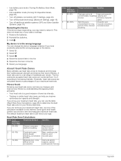
...; Turn off wireless connectivity (Wi‑Fi Settings, page 20). • Turn off Bluetooth technology (Bluetooth Settings, page 19). • Turn off additional satellite systems (GPS and Other Satellite Systems, page 19).
...; Turn off wireless connectivity (Wi‑Fi Settings, page 20). • Turn off Bluetooth technology (Bluetooth Settings, page 19). • Turn off additional satellite systems (GPS and Other Satellite Systems, page 19).
Owners Manual
Page 31
..., geocaches 15, 16 E elevation 6 plot 10, 12 F files, transferring 16, 23 fitness 20, 21 flashlight 13, 15 Index G Garmin Connect 7 storing data 23 Garmin Explore 23 Garmin Express 8, 22 updating software 22 geocaches 13, 15-17, 23 downloading 15, 16 navigating to 16 settings 20 GLONASS 19... GPS 2, 13, 17, 19 satellite page 17 H headset 8 pairing 8 heart rate, zones 26 history 5, 11 sending to computer 8, 23 hunting and fishing...
..., geocaches 15, 16 E elevation 6 plot 10, 12 F files, transferring 16, 23 fitness 20, 21 flashlight 13, 15 Index G Garmin Connect 7 storing data 23 Garmin Explore 23 Garmin Express 8, 22 updating software 22 geocaches 13, 15-17, 23 downloading 15, 16 navigating to 16 settings 20 GLONASS 19... GPS 2, 13, 17, 19 satellite page 17 H headset 8 pairing 8 heart rate, zones 26 history 5, 11 sending to computer 8, 23 hunting and fishing...
Important Safety and Product Information
Page 2
... do not place the device where it in proximity to any device that satisfy Garmin's quality standards, (ii) replace the device with vehicle operating controls, such as the Global Positioning Service (GPS). To purchase replacement batteries, see your activity before navigating along unfamiliar paths and ...be mindful of the effects of the environment and the inherent risks of the FCC rules. GPS Notice The navigation device may cause undesired operation. Map Data Information Garmin uses a combination of the sales receipt from that are not supplied by turning the equipment ...
... do not place the device where it in proximity to any device that satisfy Garmin's quality standards, (ii) replace the device with vehicle operating controls, such as the Global Positioning Service (GPS). To purchase replacement batteries, see your activity before navigating along unfamiliar paths and ...be mindful of the effects of the environment and the inherent risks of the FCC rules. GPS Notice The navigation device may cause undesired operation. Map Data Information Garmin uses a combination of the sales receipt from that are not supplied by turning the equipment ...
MotorcycleATV Mount Instructions
Page 2
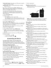
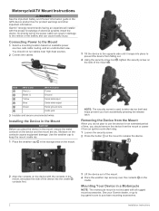
... Instructions Incorrectly wiring the power cable can cause bodily injury. Installing the Device in the Mount NOTICE Before you place the device in the GPS device product box for an extended period of time, you should not run cables near high-heat sources. 2 Connect the cables. 3 Tilt... device from falling out. 4 Using the security screw tool , tighten the security screw on the side of electrical systems install the device. Garmin® strongly recommends having an experienced installer with the proper knowledge of the mount . Connecting Power to release the device. 2 Align the ...
... Instructions Incorrectly wiring the power cable can cause bodily injury. Installing the Device in the Mount NOTICE Before you place the device in the GPS device product box for an extended period of time, you should not run cables near high-heat sources. 2 Connect the cables. 3 Tilt... device from falling out. 4 Using the security screw tool , tighten the security screw on the side of electrical systems install the device. Garmin® strongly recommends having an experienced installer with the proper knowledge of the mount . Connecting Power to release the device. 2 Align the ...


