Owner's Manual
Page 4
... Field Options 12 Calibrate Electronic Compass 13 ELEVATION PAGE 14-18 Plot Over Time/Distance 15 Zoom Ranges 15 Options 16 View Points 16 Reset 16 Calibrate Altimeter 17 Data Fields 18 TRIP COMPUTER 19-20 Data Field Options 20 MENU PAGE 21-33 Menu Navigation 21 Waypoints 22 ...Timeout 36 Contrast 36 Units 37 Position Format 37 Map Datums 37 Units of Measure 38 Interface 39 Heading 40 North Reference 40 System 42 GPS Mode 42 Compass Setting 43 Altimeter Setting 43 Battery Setting 43 Languages 44 Owner Info 44 APPENDICES 45-47 Appendix A: Specifications 45...
... Field Options 12 Calibrate Electronic Compass 13 ELEVATION PAGE 14-18 Plot Over Time/Distance 15 Zoom Ranges 15 Options 16 View Points 16 Reset 16 Calibrate Altimeter 17 Data Fields 18 TRIP COMPUTER 19-20 Data Field Options 20 MENU PAGE 21-33 Menu Navigation 21 Waypoints 22 ...Timeout 36 Contrast 36 Units 37 Position Format 37 Map Datums 37 Units of Measure 38 Interface 39 Heading 40 North Reference 40 System 42 GPS Mode 42 Compass Setting 43 Altimeter Setting 43 Battery Setting 43 Languages 44 Owner Info 44 APPENDICES 45-47 Appendix A: Specifications 45...
Owner's Manual
Page 14
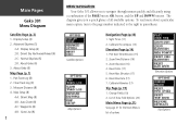
... (17) 5. Reset Elev Data (17) 7. List of Data Field Options (20) Main Menu Page (p.21) See page 21 for the Main Menu's list of all available options. Map Setup (8) 4-A: Orient Map (8) 4-B: Auto Zoom (8) 4-C: Waypoints (8) 4-D: Goto Line (8) 2 MENU NAVIGATION Your Geko 301 allows you a ...options Elevation Options Trip Options Change Fields (19) 2. Sight 'N Go (11) 2. Zoom Time/Distance (16) 3. Display Setup (4) 2. Main Pages Geko 301 Menu Diagram Satellite Page (p. 3) 1. Clear Track Log (9) 3. Measure Distance (8) 4. To read more about a particular menu option, turn to the ...
... (17) 5. Reset Elev Data (17) 7. List of Data Field Options (20) Main Menu Page (p.21) See page 21 for the Main Menu's list of all available options. Map Setup (8) 4-A: Orient Map (8) 4-B: Auto Zoom (8) 4-C: Waypoints (8) 4-D: Goto Line (8) 2 MENU NAVIGATION Your Geko 301 allows you a ...options Elevation Options Trip Options Change Fields (19) 2. Sight 'N Go (11) 2. Zoom Time/Distance (16) 3. Display Setup (4) 2. Main Pages Geko 301 Menu Diagram Satellite Page (p. 3) 1. Clear Track Log (9) 3. Measure Distance (8) 4. To read more about a particular menu option, turn to the ...
Owner's Manual
Page 24
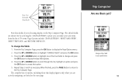
...; Time/Date-the current time and date based on your Time Zone settings. • Trip Odometer-the total distance you've gone since the last reset. • Heading-the direction you are going. • Elevation-the measurement of your arrival, based on your current speed and distance left. • Final Distance...
...; Time/Date-the current time and date based on your Time Zone settings. • Trip Odometer-the total distance you've gone since the last reset. • Heading-the direction you are going. • Elevation-the measurement of your arrival, based on your current speed and distance left. • Final Distance...

Owner's Manual
Page 26
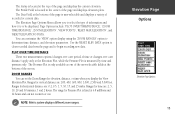
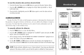
... for information on calibrating the Altimeter. A single user-selectable data field allows you to display a variety of measurement, viewing elevation or pressure points, and resetting data displays. The Elevation Page Options Menu allows you to select from a variety of display options such as plotting over time, plotting over time (displayed...
... for information on calibrating the Altimeter. A single user-selectable data field allows you to display a variety of measurement, viewing elevation or pressure points, and resetting data displays. The Elevation Page Options Menu allows you to select from a variety of display options such as plotting over time, plotting over time (displayed...
Owner's Manual
Page 27
...for horizontal distance are : 2, 5, 10, 20 and 30 minutes, 1 and 2 hours. Elevation Page Options Elevation Page Options 15 Use the 'RESET ELEV DATA' option to clear recorded data from the page and to determine time, distance, and elevation parameters. The range for vertical distance are:...1,000, 2,500 and 5,000 feet. Page Options include: 'PLOT OVER TIME/DISTANCE', 'ZOOM TIME/DISTANCE', 'ZOOM ELEVATION', 'VIEW POINTS', 'RESET MAX ELEVATION', and 'RESET ELEV(ATION) DATA'. Ranges for Pressure Plot is fixed at 6.8 millibars and 12 hours and can set distance) apply only to be ...
...for horizontal distance are : 2, 5, 10, 20 and 30 minutes, 1 and 2 hours. Elevation Page Options Elevation Page Options 15 Use the 'RESET ELEV DATA' option to clear recorded data from the page and to determine time, distance, and elevation parameters. The range for vertical distance are:...1,000, 2,500 and 5,000 feet. Page Options include: 'PLOT OVER TIME/DISTANCE', 'ZOOM TIME/DISTANCE', 'ZOOM ELEVATION', 'VIEW POINTS', 'RESET MAX ELEVATION', and 'RESET ELEV(ATION) DATA'. Ranges for Pressure Plot is fixed at 6.8 millibars and 12 hours and can set distance) apply only to be ...

Owner's Manual
Page 28
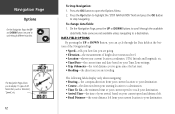
... stored elevation profile and to view the elevation plot points. Elevation Page Options Elevation Plot by Distance Elevation Plot by selecting the 'RESET' option from the Elevation Page Options Menu. Press the UP or DOWN Buttons to select the zoom level. 3. The UP Arrow Button moves... along the profile, the display shows the elevation, time of page changes to select which zoom level you want by distance. RESET You can reset the maximum elevation data and the elevation data by Time 'View Points' Option 16 To adjust zoom ranges: 1. From the Elevation Page,...
... stored elevation profile and to view the elevation plot points. Elevation Page Options Elevation Plot by Distance Elevation Plot by selecting the 'RESET' option from the Elevation Page Options Menu. Press the UP or DOWN Buttons to select the zoom level. 3. The UP Arrow Button moves... along the profile, the display shows the elevation, time of page changes to select which zoom level you want by distance. RESET You can reset the maximum elevation data and the elevation data by Time 'View Points' Option 16 To adjust zoom ranges: 1. From the Elevation Page,...
Owner's Manual
Page 29
... the OK Button. 4. Press the UP or DOWN Button to highlight the 'CALIBRATE' option and press the OK Button. CALIBRATE ALTIMETER Because the Geko 301 relies on the Barometric pressure to determine the elevation and the pressure at your Barometric pressure of the area you reside in, you can calibrate... open the Elevation Options Menu. 2. Select the 'ALTIMETER' option. 3. From the Elevation Page, press the OK Button to access the Main Menu. 2. To reset the elevation data and max elevation fields: 1. To manually calibrate the altimeter: 1. Use the UP, DOWN, and OK Buttons to...
... the OK Button. 4. Press the UP or DOWN Button to highlight the 'CALIBRATE' option and press the OK Button. CALIBRATE ALTIMETER Because the Geko 301 relies on the Barometric pressure to determine the elevation and the pressure at your Barometric pressure of the area you reside in, you can calibrate... open the Elevation Options Menu. 2. Select the 'ALTIMETER' option. 3. From the Elevation Page, press the OK Button to access the Main Menu. 2. To reset the elevation data and max elevation fields: 1. To manually calibrate the altimeter: 1. Use the UP, DOWN, and OK Buttons to...
Owner's Manual
Page 31
... highlight 'CHANGE FIELDS' and press the OK Button. 3. Press the UP or DOWN Button to highlight one of 34 items. Page Options include 'CHANGE FIELDS', 'RESET MAX SPEED', 'RESET TRIP DATA', and 'RESTORE DEFAULTS'.
... highlight 'CHANGE FIELDS' and press the OK Button. 3. Press the UP or DOWN Button to highlight one of 34 items. Page Options include 'CHANGE FIELDS', 'RESET MAX SPEED', 'RESET TRIP DATA', and 'RESTORE DEFAULTS'.
Owner's Manual
Page 32
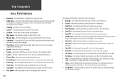
...Next Dist-(Next Distance) the distance between second-by-second position readings. • Over'l Spd-(Overall Speed) the averaged speed since your last reset, including stopped and moving time. • Speed-shows how fast you are going. • Sunrise-the time at which the sun rises...8226; Heading-the direction you are traveling. • Lat/Lon-(Latitude/Longitude) the current GPS position. • Location-shows your current latitude and longitude. • Max Speed-the maximum speed traveled since last reset. • Moving Avg-(Moving Average) the average speed while the unit is moving. ...
...Next Dist-(Next Distance) the distance between second-by-second position readings. • Over'l Spd-(Overall Speed) the averaged speed since your last reset, including stopped and moving time. • Speed-shows how fast you are going. • Sunrise-the time at which the sun rises...8226; Heading-the direction you are traveling. • Lat/Lon-(Latitude/Longitude) the current GPS position. • Location-shows your current latitude and longitude. • Max Speed-the maximum speed traveled since last reset. • Moving Avg-(Moving Average) the average speed while the unit is moving. ...
Owner's Manual
Page 62
... (Final cont.) ETE 20 Final Destination 20 Final Distance 12 G Games Gekoids 32 Geko Smak 32 Memory Race 33 Nibbons 33 Virtua Maze 33 GARMIN DGPS 39 Glide Ratio 20 Glide Ratio Destination 20 GOTO 9, 24 GOTO Line 8 GPS Cleaning viii GPS Mode 42, 43 H Heading 12, 20 Setup Page 10 Heading Page 40... How To adjust zoom ranges 16 calibrate the altimeter 17 calibrate the compass 13 reset the elevation data 17 reset the max elevation fields 17 use the View...
... (Final cont.) ETE 20 Final Destination 20 Final Distance 12 G Games Gekoids 32 Geko Smak 32 Memory Race 33 Nibbons 33 Virtua Maze 33 GARMIN DGPS 39 Glide Ratio 20 Glide Ratio Destination 20 GOTO 9, 24 GOTO Line 8 GPS Cleaning viii GPS Mode 42, 43 H Heading 12, 20 Setup Page 10 Heading Page 40... How To adjust zoom ranges 16 calibrate the altimeter 17 calibrate the compass 13 reset the elevation data 17 reset the max elevation fields 17 use the View...
Owner's Manual
Page 64
Index 52 Profile Field 15 Projecting a Waypoint 25 R Registration i Reset 16 Review Waypoint Page 24 Routes 29-31 RTCM/NMEA 39 RTCM/TEXT 39 RTCM IN 39 S Satellite Page 3-6 Select a Waypoint 23 Settings Input 39 ... 45 Speed 12, 20 Maximum 20 (Speed cont.) Overall 20 Vertical 20 Stopped Time 20 Stop Navigation 8 Storage viii Sunrise 20 Sunset 20 System Page GPS Mode 42, 43 Owner Info 44 T TEXT OUT 39 Time Moving 20 Of Day 20 Stopped 20 Total 20 Time/Date 12 Time Page 34...
Index 52 Profile Field 15 Projecting a Waypoint 25 R Registration i Reset 16 Review Waypoint Page 24 Routes 29-31 RTCM/NMEA 39 RTCM/TEXT 39 RTCM IN 39 S Satellite Page 3-6 Select a Waypoint 23 Settings Input 39 ... 45 Speed 12, 20 Maximum 20 (Speed cont.) Overall 20 Vertical 20 Stopped Time 20 Stop Navigation 8 Storage viii Sunrise 20 Sunset 20 System Page GPS Mode 42, 43 Owner Info 44 T TEXT OUT 39 Time Moving 20 Of Day 20 Stopped 20 Total 20 Time/Date 12 Time Page 34...


