
Owner's Manual
Page 4
... 17 Data Fields 18 TRIP COMPUTER 19-20 Data Field Options 20 MENU PAGE 21-33 Menu Navigation 21 Waypoints 22 Mark Waypoint Page 22 Review Waypoint Page 24 Tracks 26 Routes 29 Games 32 SETUP PAGE 34-44 Time Page 34 Time Zone 34 Daylight Savings Time 35 Display 36... Timeout 36 Contrast 36 Units 37 Position Format 37 Map Datums 37 Units of Measure 38 Interface 39 Heading 40 North Reference 40 System 42 GPS Mode 42 Compass Setting 43 Altimeter Setting 43 Battery Setting 43 Languages 44 Owner Info 44 APPENDICES 45-47 Appendix A: Specifications 45 Appendix...
... 17 Data Fields 18 TRIP COMPUTER 19-20 Data Field Options 20 MENU PAGE 21-33 Menu Navigation 21 Waypoints 22 Mark Waypoint Page 22 Review Waypoint Page 24 Tracks 26 Routes 29 Games 32 SETUP PAGE 34-44 Time Page 34 Time Zone 34 Daylight Savings Time 35 Display 36... Timeout 36 Contrast 36 Units 37 Position Format 37 Map Datums 37 Units of Measure 38 Interface 39 Heading 40 North Reference 40 System 42 GPS Mode 42 Compass Setting 43 Altimeter Setting 43 Battery Setting 43 Languages 44 Owner Info 44 APPENDICES 45-47 Appendix A: Specifications 45 Appendix...
Owner's Manual
Page 6
...surveillance of all driving conditions at your own risk. Failure by the driver of all times, and not become unsafe. Although the Garmin GPS receiver is solely responsible for its accuracy and maintenance. WARNING: For use in vehicles, it the sole responsibility of the driver of the... TO USE THIS PRODUCT PRUDENTLY. To reduce the risk of unsafe operation, carefully review and understand all available navigation sources, including the information from the Geko 301 to operate the controls of the Geko 301 while you are driving. For safety, always resolve any NAVAID can be misused ...
...surveillance of all driving conditions at your own risk. Failure by the driver of all times, and not become unsafe. Although the Garmin GPS receiver is solely responsible for its accuracy and maintenance. WARNING: For use in vehicles, it the sole responsibility of the driver of the... TO USE THIS PRODUCT PRUDENTLY. To reduce the risk of unsafe operation, carefully review and understand all available navigation sources, including the information from the Geko 301 to operate the controls of the Geko 301 while you are driving. For safety, always resolve any NAVAID can be misused ...
Owner's Manual
Page 34
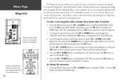
... the UP or DOWN Button to highlight the 'OK' field and press the OK Button to scroll through the position coordinate places using the Review Waypoint Page. You can then change the waypoint symbol, name, elevation and location (latitude and longitude) using the UP or DOWN Button (UP Button to...
... the UP or DOWN Button to highlight the 'OK' field and press the OK Button to scroll through the position coordinate places using the Review Waypoint Page. You can then change the waypoint symbol, name, elevation and location (latitude and longitude) using the UP or DOWN Button (UP Button to...
Owner's Manual
Page 35
... and press the OK Button to display the ENTER CORRECT ELEVATION Page. 3. From the MENU Page press the UP or DOWN Button to display the REVIEW WAYPOINT Page. Press the UP or DOWN Button to highlight the 'ELEV' field and press the OK Button to display the...
... and press the OK Button to display the ENTER CORRECT ELEVATION Page. 3. From the MENU Page press the UP or DOWN Button to display the REVIEW WAYPOINT Page. Press the UP or DOWN Button to highlight the 'ELEV' field and press the OK Button to display the...
Owner's Manual
Page 36
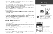
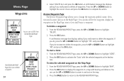
... and location (just as the destina- To delete a waypoint: 1. Press the OK Button. If you to display the waypoint on the Map Page: 1. tion. The REVIEW WAYPOINT Page allows you do , press the UP or DOWN Button to highlight 'NO' and press the OK Button. Press the OK Button to delete... press the OK Button. Press the UP or DOWN Button to highlight the correct choice and press the OK Button to highlight 'DELETE'. 2. From the REVIEW WAYPOINT Page, press the UP or DOWN Button to complete the action. A confirmation message box displays asking if you do not want to...
... and location (just as the destina- To delete a waypoint: 1. Press the OK Button. If you to display the waypoint on the Map Page: 1. tion. The REVIEW WAYPOINT Page allows you do , press the UP or DOWN Button to highlight 'NO' and press the OK Button. Press the OK Button to delete... press the OK Button. Press the UP or DOWN Button to highlight the correct choice and press the OK Button to highlight 'DELETE'. 2. From the REVIEW WAYPOINT Page, press the UP or DOWN Button to complete the action. A confirmation message box displays asking if you do not want to...
Owner's Manual
Page 37
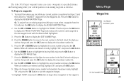
Press the OK Button to display the EDIT NUMBER Page. 4. Press the OK Button to display the REVIEW WAYPOINT Page. When all numbers are entered correctly, highlight 'OK' and press the OK Button. 9. Highlight 'GOTO' and press the OK Button to begin...;eld. Menu Page Waypoints The 'PROJECT WAYPOINT' option The 'EDIT NUMBER' field 25 Press the DOWN Button to display the REVIEW WAYPOINT Page. 2. To Project a waypoint: 1. The Geko 301's Project waypoint feature can create a waypoint at a specified distance and bearing using either your current position or an existing waypoint...
Press the OK Button to display the EDIT NUMBER Page. 4. Press the OK Button to display the REVIEW WAYPOINT Page. When all numbers are entered correctly, highlight 'OK' and press the OK Button. 9. Highlight 'GOTO' and press the OK Button to begin...;eld. Menu Page Waypoints The 'PROJECT WAYPOINT' option The 'EDIT NUMBER' field 25 Press the DOWN Button to display the REVIEW WAYPOINT Page. 2. To Project a waypoint: 1. The Geko 301's Project waypoint feature can create a waypoint at a specified distance and bearing using either your current position or an existing waypoint...

Owner's Manual
Page 64
Index 52 Profile Field 15 Projecting a Waypoint 25 R Registration i Reset 16 Review Waypoint Page 24 Routes 29-31 RTCM/NMEA 39 RTCM/TEXT 39 RTCM IN 39 S Satellite Page 3-6 Select a Waypoint 23 Settings Input 39 Set course ... 45 Speed 12, 20 Maximum 20 (Speed cont.) Overall 20 Vertical 20 Stopped Time 20 Stop Navigation 8 Storage viii Sunrise 20 Sunset 20 System Page GPS Mode 42, 43 Owner Info 44 T TEXT OUT 39 Time Moving 20 Of Day 20 Stopped 20 Total 20 Time/Date 12 Time Page 34...
Index 52 Profile Field 15 Projecting a Waypoint 25 R Registration i Reset 16 Review Waypoint Page 24 Routes 29-31 RTCM/NMEA 39 RTCM/TEXT 39 RTCM IN 39 S Satellite Page 3-6 Select a Waypoint 23 Settings Input 39 Set course ... 45 Speed 12, 20 Maximum 20 (Speed cont.) Overall 20 Vertical 20 Stopped Time 20 Stop Navigation 8 Storage viii Sunrise 20 Sunset 20 System Page GPS Mode 42, 43 Owner Info 44 T TEXT OUT 39 Time Moving 20 Of Day 20 Stopped 20 Total 20 Time/Date 12 Time Page 34...