
Installation Instructions
Page 10
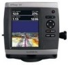
...the operation of the boat and put the transducer at a slow speed. GPSMAP 526/536/546/556 (s): High-sensitivity 12 parallel channel WAAS-capable receiver. It might have to move the transducer to a different location. Placing the transducer too deep can adversely affect the performance of... adjusting the depth of 4,096 colors. diagonal (10.6 cm), QVGA display with adjustable brightness, 320 × 234 pixels. Temp. If the sonar signal suddenly is lost . GPSMAP 520/521/530/531/540/541/550/551 (s): 5.0 in small increments. Update Rate: 1/second, continuous GPS Accuracy: Position...
...the operation of the boat and put the transducer at a slow speed. GPSMAP 526/536/546/556 (s): High-sensitivity 12 parallel channel WAAS-capable receiver. It might have to move the transducer to a different location. Placing the transducer too deep can adversely affect the performance of... adjusting the depth of 4,096 colors. diagonal (10.6 cm), QVGA display with adjustable brightness, 320 × 234 pixels. Temp. If the sonar signal suddenly is lost . GPSMAP 520/521/530/531/540/541/550/551 (s): 5.0 in small increments. Update Rate: 1/second, continuous GPS Accuracy: Position...
Installation Instructions
Page 11
... Error Navigation Data Navigation - Command/Request/Acknowledge Group Function Transmit/Receive PGN List Group Function Product Information Water Depth Speed - Sonar Power: 1 kW Transducer, 1,000 W (RMS), 8,000 W (peak to peak); (1 kW transducers are NMEA 2000 certified. 130314 Actual Pressure NMEA 0183, Version ...Marine Electronics Association (NMEA) format and sentences from: NMEA Seven Riggs Avenue Severna Park, MD 21146 USA www.nmea.org GPSMAP 400/500 Series Installation Instructions 11 Dual Beam, 400 W (RMS), 3,200 W (peak to NMEA 2000-Compatible Chartplotters): Receive...
... Error Navigation Data Navigation - Command/Request/Acknowledge Group Function Transmit/Receive PGN List Group Function Product Information Water Depth Speed - Sonar Power: 1 kW Transducer, 1,000 W (RMS), 8,000 W (peak to peak); (1 kW transducers are NMEA 2000 certified. 130314 Actual Pressure NMEA 0183, Version ...Marine Electronics Association (NMEA) format and sentences from: NMEA Seven Riggs Avenue Severna Park, MD 21146 USA www.nmea.org GPSMAP 400/500 Series Installation Instructions 11 Dual Beam, 400 W (RMS), 3,200 W (peak to NMEA 2000-Compatible Chartplotters): Receive...
Technical Reference for Garmin NMEA 2000 Products
Page 4
... GST 10 (Garmin Water Speed and Temperature Adapter)...19 Intelliducer (Intelligent Depth Transducer-Transom Mount and Thru-Hull)...19 GWS 10 (Garmin Wind Sensor)...20 GHP 10 (Marine Autopilot System)...20 GXM 51...21 VHF 200...21 VHF 300...21 AIS 300...22 AIS 600...22 NMEA 2000-Certified Sensor Configuration Information...23 GPS 17x (GPS Antenna)...23...
... GST 10 (Garmin Water Speed and Temperature Adapter)...19 Intelliducer (Intelligent Depth Transducer-Transom Mount and Thru-Hull)...19 GWS 10 (Garmin Wind Sensor)...20 GHP 10 (Marine Autopilot System)...20 GXM 51...21 VHF 200...21 VHF 300...21 AIS 300...22 AIS 600...22 NMEA 2000-Certified Sensor Configuration Information...23 GPS 17x (GPS Antenna)...23...

Technical Reference for Garmin NMEA 2000 Products
Page 16
... - Envir Param 128259 - COG/SOG and 129029 - GNSS Position None None Typical Sender Depth Transducer Water Temperature Sensor Water Speed Sensor GPS Antenna, Water Speed Sensor, and Heading Sensor GPS Antenna, Water Speed Sensor, and Heading Sensor GPS Antenna GPS Antenna None None 12 Technical Reference for Garmin NMEA 2000 Products COG/SOG, 129029 - GNSS Position, 128259 - General NMEA 2000...
... - Envir Param 128259 - COG/SOG and 129029 - GNSS Position None None Typical Sender Depth Transducer Water Temperature Sensor Water Speed Sensor GPS Antenna, Water Speed Sensor, and Heading Sensor GPS Antenna, Water Speed Sensor, and Heading Sensor GPS Antenna GPS Antenna None None 12 Technical Reference for Garmin NMEA 2000 Products COG/SOG, 129029 - GNSS Position, 128259 - General NMEA 2000...

Technical Reference for Garmin NMEA 2000 Products
Page 23
... 10 (Garmin Fluid Level Adapter) Transmit 059392 ISO Acknowledgment 060928 ISO Address Claim 126208 NMEA - Command/Request/Acknowledge Group Function 126996 Product Information 128259 Speed - NMEA 2000-Certified Sensor PGN Information Transmit 126464 126996 127488 Transmit/Receive PGN List Group Function Product Information Engine Parameters - Water Referenced 130312 Temperature Intelliducer (Intelligent Depth Transducer-Transom Mount...
... 10 (Garmin Fluid Level Adapter) Transmit 059392 ISO Acknowledgment 060928 ISO Address Claim 126208 NMEA - Command/Request/Acknowledge Group Function 126996 Product Information 128259 Speed - NMEA 2000-Certified Sensor PGN Information Transmit 126464 126996 127488 Transmit/Receive PGN List Group Function Product Information Engine Parameters - Water Referenced 130312 Temperature Intelliducer (Intelligent Depth Transducer-Transom Mount...
Technical Reference for Garmin NMEA 2000 Products
Page 40
... mast of the keel. Configuring the Wind Speed Filter The wind speed filter governs how quickly the NMEA 2000-compatible display device shows a change more gradually, and may stabilize the display. NMEA 2000 Checklist Intelliducer (Intelligent Depth Transducer-Transom Mount and Thru-Hull) Setting the ...needle or wind speed number to show depth at the bottom of the Intelliducer. To configure the wind speed filter: 1. Choose from the lowest point of the boat (keel) rather than the actual location of the keel Enter a (-) negative number to adjust for Garmin NMEA 2000 Products...
... mast of the keel. Configuring the Wind Speed Filter The wind speed filter governs how quickly the NMEA 2000-compatible display device shows a change more gradually, and may stabilize the display. NMEA 2000 Checklist Intelliducer (Intelligent Depth Transducer-Transom Mount and Thru-Hull) Setting the ...needle or wind speed number to show depth at the bottom of the Intelliducer. To configure the wind speed filter: 1. Choose from the lowest point of the boat (keel) rather than the actual location of the keel Enter a (-) negative number to adjust for Garmin NMEA 2000 Products...

Owner's Manual
Page 16
...the top of the screen to most charts include depth contour lines (with a Garmin Intelliducer™ attached). • Fuel-(available ...Fishing-turn the Depth, Water Temperature, and Water Speed data bar on or off (available when using an "s" series unit with a transducer attached, or ...a "non-s" series unit with deep water represented in white), intertidal zones, spot soundings (as depicted on the original paper chart), navigational aids and symbols, and obstructions and cable areas. 10 GPSMAP...
...the top of the screen to most charts include depth contour lines (with a Garmin Intelliducer™ attached). • Fuel-(available ...Fishing-turn the Depth, Water Temperature, and Water Speed data bar on or off (available when using an "s" series unit with a transducer attached, or ...a "non-s" series unit with deep water represented in white), intertidal zones, spot soundings (as depicted on the original paper chart), navigational aids and symbols, and obstructions and cable areas. 10 GPSMAP...
Owner's Manual
Page 54
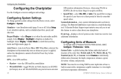
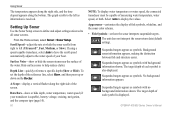
... Configure > Preferences > Units. Configuring Units of measure from the Home screen, select Configure > System. Note: You must be receiving NMEA sonar depth data or have a built-in Europe) on or off. Simulator-turn Simulator mode (page 5) on whenever power is applied, ...provide more-accurate 48 GPS position information. System Information-view system information and reset factory settings. GPSMAP 400/500 Series Owner's Manual Select Display > Color Mode to acquire satellites. • Speed Filter-select On, Off, or Auto. The Save to view depth and water temperature ...
... Configure > Preferences > Units. Configuring Units of measure from the Home screen, select Configure > System. Note: You must be receiving NMEA sonar depth data or have a built-in Europe) on or off. Simulator-turn Simulator mode (page 5) on whenever power is applied, ...provide more-accurate 48 GPS position information. System Information-view system information and reset factory settings. GPSMAP 400/500 Series Owner's Manual Select Display > Color Mode to acquire satellites. • Speed Filter-select On, Off, or Auto. The Save to view depth and water temperature ...
Owner's Manual
Page 61
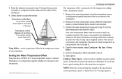
...depth at the surface. GPSMAP 400/500 Series Owner's Manual Configuring the Chartplotter The temperature offset compensates for the temperature sensor of the transducer. 4. If you enter a positive or a negative number based on -screen directions for calibration. Measure the water temperature using the temperature sensor or temperature-capable transducer that is not registering a speed, a "Speed...sensor, a Garmin Intelliducer, or a temperature-capable transducer to calibrate a speed-sensing device. Enter the temperature offset calculated in step 1. Calibrate Water Speed-use this...
...depth at the surface. GPSMAP 400/500 Series Owner's Manual Configuring the Chartplotter The temperature offset compensates for the temperature sensor of the transducer. 4. If you enter a positive or a negative number based on -screen directions for calibration. Measure the water temperature using the temperature sensor or temperature-capable transducer that is not registering a speed, a "Speed...sensor, a Garmin Intelliducer, or a temperature-capable transducer to calibrate a speed-sensing device. Enter the temperature offset calculated in step 1. Calibrate Water Speed-use this...
Owner's Manual
Page 63
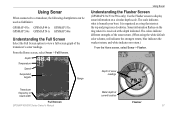
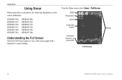
... following chartplotters can be used as a ring that starts at the top and progresses clockwise. Depth of the transducer's sonar readings. It is beneath your boat. From the Home screen, select Sonar > Full Screen. The colors ...organized as fishfinders: GPSMAP 431s GPSMAP 441s GPSMAP 531s GPSMAP 536s GPSMAP 541s GPSMAP 546s Understanding the Full Screen Select the Full Screen option to display sonar information on the ring when it is received at current location Flasher 57 Sonar information flashes on a circular depth scale. Depth Temperature Speed Suspended targets Range...
... following chartplotters can be used as a ring that starts at the top and progresses clockwise. Depth of the transducer's sonar readings. It is beneath your boat. From the Home screen, select Sonar > Full Screen. The colors ...organized as fishfinders: GPSMAP 431s GPSMAP 441s GPSMAP 531s GPSMAP 536s GPSMAP 541s GPSMAP 546s Understanding the Full Screen Select the Full Screen option to display sonar information on the ring when it is received at current location Flasher 57 Sonar information flashes on a circular depth scale. Depth Temperature Speed Suspended targets Range...
Owner's Manual
Page 64
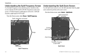
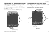
... from the graph and a zoomed in portion on the same screen. Depth, temperature, and speed Range Frequencies Split Frequency 58 Zoomed depth scale Zoom window Range Zoom level Transducer frequency or beam width Split Zoom GPSMAP 400/500 Series Owner's Manual Depth, temperature, and speed Understanding the Split Zoom Screen Use the Split Zoom screen to view...
... from the graph and a zoomed in portion on the same screen. Depth, temperature, and speed Range Frequencies Split Frequency 58 Zoomed depth scale Zoom window Range Zoom level Transducer frequency or beam width Split Zoom GPSMAP 400/500 Series Owner's Manual Depth, temperature, and speed Understanding the Split Zoom Screen Use the Split Zoom screen to view...
Owner's Manual
Page 66
... each symbol is displayed. To set how the sonar interprets suspended targets. Select Auto to the water speed of your transducer is received. GPSMAP 400/500 Series Owner's Manual Surface Noise-show or hide depth, water temperature, water speed (if your boat. Appearance-customize the display of fish symbols, whiteline, and the sonar color scheme. •...
... each symbol is displayed. To set how the sonar interprets suspended targets. Select Auto to the water speed of your transducer is received. GPSMAP 400/500 Series Owner's Manual Surface Noise-show or hide depth, water temperature, water speed (if your boat. Appearance-customize the display of fish symbols, whiteline, and the sonar color scheme. •...
Owner's Manual
Page 87
... off. If the transducer cable is removed while the unit is set to Fill. Water Temperature Alarm-sonar has reported a temperature above, below, inside, or outside the specified values. GPSMAP 400/500 Series Owner's Manual 81 Shallow Water Alarm-the Shallow Water Alarm depth has been reached. ... the connections. Contact your dealer or Garmin Product Support to needs a software update. Sonar Service Lost-the external sonar device you entered a saved track name that already exists in the SD card slot. Water Speed Sensor Is Not Working-the speed sensor is full. Route Waypoint Memory Full...
... off. If the transducer cable is removed while the unit is set to Fill. Water Temperature Alarm-sonar has reported a temperature above, below, inside, or outside the specified values. GPSMAP 400/500 Series Owner's Manual 81 Shallow Water Alarm-the Shallow Water Alarm depth has been reached. ... the connections. Contact your dealer or Garmin Product Support to needs a software update. Sonar Service Lost-the external sonar device you entered a saved track name that already exists in the SD card slot. Water Speed Sensor Is Not Working-the speed sensor is full. Route Waypoint Memory Full...
Owner's Manual
Page 93
...32 labels 49 viewing 44 route to 28 S safe-zone settings 56 Safe Depth 18, 50 Safe Height 50 Safety Shading 14 safe zone collision alarm 26 ... 19 Saved Tracks 16 Save To Card 45, 46, 48 screenshots 82 scroll speed 60 SD cards inserting 6 removing 6 sea conditions 74 SELECT key 5 Serial... zoom 58 temperature log 59 specifications 77 Speed Filter 48 Speed Sources 49 Split Frequency 58 Split Zoom 58 spot depths 14 Stop Navigation 9 storm cells 70... information 12 Time (options) 49 Time to 56 tracks 18, 33 Trails 25 transducer dual frequency 61 transferring data 44, 45 Trip Odometer 37 True (north) 49...
...32 labels 49 viewing 44 route to 28 S safe-zone settings 56 Safe Depth 18, 50 Safe Height 50 Safety Shading 14 safe zone collision alarm 26 ... 19 Saved Tracks 16 Save To Card 45, 46, 48 screenshots 82 scroll speed 60 SD cards inserting 6 removing 6 sea conditions 74 SELECT key 5 Serial... zoom 58 temperature log 59 specifications 77 Speed Filter 48 Speed Sources 49 Split Frequency 58 Split Zoom 58 spot depths 14 Stop Navigation 9 storm cells 70... information 12 Time (options) 49 Time to 56 tracks 18, 33 Trails 25 transducer dual frequency 61 transferring data 44, 45 Trip Odometer 37 True (north) 49...
Owner's Manual
Page 54
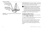
... offset for boats that are within range and equipped with a transponder. If you get the message, contact Garmin Product Support. If you do not have a speed-sensing device, this menu to an external AIS or DSC device. Fuel Capacity-enter the total fuel capacity .... 48 GPSMAP 400/500 Series Owner's Manual If you to get the message again, stop the boat and make sure the speed-sensor wheel is not registering a speed, a "Speed Too Low" message appears. Configuring the Chartplotter Transducer at Surface A (+) positive number shows depth at the surface. Calibrate Water Speed-use of...
... offset for boats that are within range and equipped with a transponder. If you get the message, contact Garmin Product Support. If you do not have a speed-sensing device, this menu to an external AIS or DSC device. Fuel Capacity-enter the total fuel capacity .... 48 GPSMAP 400/500 Series Owner's Manual If you to get the message again, stop the boat and make sure the speed-sensor wheel is not registering a speed, a "Speed Too Low" message appears. Configuring the Chartplotter Transducer at Surface A (+) positive number shows depth at the surface. Calibrate Water Speed-use of...
Owner's Manual
Page 56
From the Home screen, select Sonar > Full Screen. Depth Temperature Speed Suspended targets Transducer frequency or beam width Full Screen Range 50 GPSMAP 400/500 Series Owner's Manual Using Sonar Using Sonar When connected to a transducer, the following chartplotters can be used as fishfinders: GPSMAP 430s GPSMAP 431s GPSMAP 530s GPSMAP 531s GPSMAP 540s GPSMAP 541s GPSMAP 440s GPSMAP 441s GPSMAP 535s GPSMAP 536s GPSMAP 545s GPSMAP 546s Understanding the Full Screen Select the Full Screen option to view a full-screen graph of the transducer's sonar readings.
From the Home screen, select Sonar > Full Screen. Depth Temperature Speed Suspended targets Transducer frequency or beam width Full Screen Range 50 GPSMAP 400/500 Series Owner's Manual Using Sonar Using Sonar When connected to a transducer, the following chartplotters can be used as fishfinders: GPSMAP 430s GPSMAP 431s GPSMAP 530s GPSMAP 531s GPSMAP 540s GPSMAP 541s GPSMAP 440s GPSMAP 441s GPSMAP 535s GPSMAP 536s GPSMAP 545s GPSMAP 546s Understanding the Full Screen Select the Full Screen option to view a full-screen graph of the transducer's sonar readings.
Owner's Manual
Page 57
... Split Zoom screen to view both the 50 kHz and 200 kHz frequencies on the left; Depth, temperature, and speed Range Frequencies Split Frequency GPSMAP 400/500 Series Owner's Manual Zoomed depth scale Zoom window Range Zoom level Transducer frequency or beam width Split Zoom 51 From the Home screen, select Sonar > Split Frequency. Understanding...
... Split Zoom screen to view both the 50 kHz and 200 kHz frequencies on the left; Depth, temperature, and speed Range Frequencies Split Frequency GPSMAP 400/500 Series Owner's Manual Zoomed depth scale Zoom window Range Zoom level Transducer frequency or beam width Split Zoom 51 From the Home screen, select Sonar > Split Frequency. Understanding...
Owner's Manual
Page 58
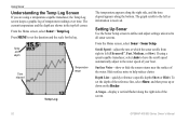
...The graph scrolls to left as information is received. Setting Up Sonar Use the Sonar Setup screen to define and adjust settings universal to help reduce clutter. Hide surface noise to all sonar screens. Depth Line-quickly reference a specific depth (Show or Hide). To set the duration ...If you are shown in the top-left corner. The current temperature and the depth are using a speed-capable transducer, select Auto to have the scroll speed automatically adjust to set the depth of the screen. 52 GPSMAP 400/500 Series Owner's Manual From the Home screen, select Sonar > Sonar ...
...The graph scrolls to left as information is received. Setting Up Sonar Use the Sonar Setup screen to define and adjust settings universal to help reduce clutter. Hide surface noise to all sonar screens. Depth Line-quickly reference a specific depth (Show or Hide). To set the duration ...If you are shown in the top-left corner. The current temperature and the depth are using a speed-capable transducer, select Auto to have the scroll speed automatically adjust to set the depth of the screen. 52 GPSMAP 400/500 Series Owner's Manual From the Home screen, select Sonar > Sonar ...
Owner's Manual
Page 59
Data Bars-show or hide battery voltage, water temperature, water speed (if your transducer is also displayed. GPSMAP 400/500 Series Owner's Manual Using Sonar • Whiteline-highlights the strongest signal from the bottom to display the values. While viewing ...softness. ◦◦ Off (default)-turns off whiteline. ◦◦ High-the most sensitive setting. Suspended targets appear as symbols. The target depth of the sonar screen. Pause Sonar-stops the scrolling of each symbol is capable), cruising, and navigation. Press SELECT. Appearance-customize the display ...
Data Bars-show or hide battery voltage, water temperature, water speed (if your transducer is also displayed. GPSMAP 400/500 Series Owner's Manual Using Sonar • Whiteline-highlights the strongest signal from the bottom to display the values. While viewing ...softness. ◦◦ Off (default)-turns off whiteline. ◦◦ High-the most sensitive setting. Suspended targets appear as symbols. The target depth of the sonar screen. Pause Sonar-stops the scrolling of each symbol is capable), cruising, and navigation. Press SELECT. Appearance-customize the display ...
Owner's Manual
Page 85
... setting up 52-53 setup 52 specifications 70 split frequency 51 split zoom 51 temperature log 52 specifications 69 Speed Filter 41 Speed Sources 43 Split Frequency 51 Split Zoom 51 spot depths 14 storm cells 62 Surface Noise 52 surface pressure 65 symbols 14 System Alarms 46 System Information 41 viewing...12 tide stations 36 viewing information 12 Time (options) 42 tracks 18, 31 Trails 25 transducer dual frequency 54 transferring data 37, 38 Trip Odometer 35 True (north) 42 turn the unit off 3 Turn Transition 42 GPSMAP 400/500 Series Owner's Manual U unit ID number 6 units of measure 41 user ...
... setting up 52-53 setup 52 specifications 70 split frequency 51 split zoom 51 temperature log 52 specifications 69 Speed Filter 41 Speed Sources 43 Split Frequency 51 Split Zoom 51 spot depths 14 storm cells 62 Surface Noise 52 surface pressure 65 symbols 14 System Alarms 46 System Information 41 viewing...12 tide stations 36 viewing information 12 Time (options) 42 tracks 18, 31 Trails 25 transducer dual frequency 54 transferring data 37, 38 Trip Odometer 35 True (north) 42 turn the unit off 3 Turn Transition 42 GPSMAP 400/500 Series Owner's Manual U unit ID number 6 units of measure 41 user ...


