
Owner's Manual
Page 5
...DSC 55 Using the Chartplotter with a VHF Radio 55 Adding a DSC Contact 56 Viewing the DSC List 56 Receiving Distress Calls 56 Man-Overboard Distress Calls Initiated from a VHF Radio........ 57 Man-Overboard Distress Calls Initiated from the...an Individual Routine Call 58 Calling an AIS Target 59 Using XM WX Weather and Audio 60 Using XM WX Weather 60 Viewing NEXRAD Precipitation Information 61 Viewing Forecast Information 64 Viewing Fishing Information 65 Viewing Sea Conditions... Agreement 76 XM Satellite Radio Service Agreement 76 Index 77 GPSMAP 400/500 Series Owner's Manual iii
...DSC 55 Using the Chartplotter with a VHF Radio 55 Adding a DSC Contact 56 Viewing the DSC List 56 Receiving Distress Calls 56 Man-Overboard Distress Calls Initiated from a VHF Radio........ 57 Man-Overboard Distress Calls Initiated from the...an Individual Routine Call 58 Calling an AIS Target 59 Using XM WX Weather and Audio 60 Using XM WX Weather 60 Viewing NEXRAD Precipitation Information 61 Viewing Forecast Information 64 Viewing Fishing Information 65 Viewing Sea Conditions... Agreement 76 XM Satellite Radio Service Agreement 76 Index 77 GPSMAP 400/500 Series Owner's Manual iii
Owner's Manual
Page 19
... if the chartplotter is always up and displays various weather parameters, including precipitation (NEXRAD), cloud cover, visibility, WX buoys, and the weather legend. See page 60 for additional information. Wind direction indicator Compass rose GPSMAP 400/500 Series Owner's Manual 13 Weather-sets up .
... if the chartplotter is always up and displays various weather parameters, including precipitation (NEXRAD), cloud cover, visibility, WX buoys, and the weather legend. See page 60 for additional information. Wind direction indicator Compass rose GPSMAP 400/500 Series Owner's Manual 13 Weather-sets up .
Owner's Manual
Page 22
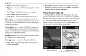
...display of tracks that have an XM subscription.) See page 60 for additional information. Data Bars (page 9)-show or hide cruising, navigation, fishing, fuel, sailing numbers, or compass tape. Mariner's Eye 3D Navigation Chart 16 GPSMAP 400/500 Series Owner's Manual Other Vessels-view information about... the chartplotter is beneficial when trying to identify entry and exit routes in unfamiliar harbors or anchorages. Using Mariner's Eye 3D A BlueChart g2 Vision SD card offers Mariner's Eye 3D, which provides a detailed three-dimensional view from above and behind the boat (according to...
...display of tracks that have an XM subscription.) See page 60 for additional information. Data Bars (page 9)-show or hide cruising, navigation, fishing, fuel, sailing numbers, or compass tape. Mariner's Eye 3D Navigation Chart 16 GPSMAP 400/500 Series Owner's Manual Other Vessels-view information about... the chartplotter is beneficial when trying to identify entry and exit routes in unfamiliar harbors or anchorages. Using Mariner's Eye 3D A BlueChart g2 Vision SD card offers Mariner's Eye 3D, which provides a detailed three-dimensional view from above and behind the boat (according to...

Owner's Manual
Page 23
...how chart data is displayed over the navaid, the navaid is connected to a weather module and you have an XM subscription.) See page 60 for additional information. The Off setting shows the land as beacons, lights, and obstructions: 1. Press SELECT to view details about navaids ..., Other Vessels, and Data Bars, see "Navigation Chart Menu" on or off . Mariner's Eye 3D (Water Hazard Colors) GPSMAP 400/500 Series Owner's Manual 17 The scale ( ) temporarily appears at the bottom of the Mariner's Eye 3D screen, select MENU > Chart Appearance. To customize the appearance of the ...
...how chart data is displayed over the navaid, the navaid is connected to a weather module and you have an XM subscription.) See page 60 for additional information. The Off setting shows the land as beacons, lights, and obstructions: 1. Press SELECT to view details about navaids ..., Other Vessels, and Data Bars, see "Navigation Chart Menu" on or off . Mariner's Eye 3D (Water Hazard Colors) GPSMAP 400/500 Series Owner's Manual 17 The scale ( ) temporarily appears at the bottom of the Mariner's Eye 3D screen, select MENU > Chart Appearance. To customize the appearance of the ...
Owner's Manual
Page 53
... your unit must have a subscription to XM WX Weather and a connected Garmin XM WX weather receiver to view weather information (page 60). 1. Keel Offset-offset the surface reading for a large vessel that may...• If you select On, use the Rocker to indicate the fuel level at the surface. 3. GPSMAP 400/500 Series Owner's Manual 47 From the Home screen, select Configure > My Boat > Keel Offset....number. If you are measuring up to the water line (transducer installed on or off: marine, tornado, severe storm, flood, or flash flood. Setting Weather Alarms Note: You must be connected to...
... your unit must have a subscription to XM WX Weather and a connected Garmin XM WX weather receiver to view weather information (page 60). 1. Keel Offset-offset the surface reading for a large vessel that may...• If you select On, use the Rocker to indicate the fuel level at the surface. 3. GPSMAP 400/500 Series Owner's Manual 47 From the Home screen, select Configure > My Boat > Keel Offset....number. If you are measuring up to the water line (transducer installed on or off: marine, tornado, severe storm, flood, or flash flood. Setting Weather Alarms Note: You must be connected to...

Owner's Manual
Page 66
.... (See the XM WX Satellite Weather Web site at http://xmwxweather.com for more information. Using XM WX Weather The Garmin XM receiver and antenna receives XM WX weather data and shows it can change in Simulator mode. The weather data for each feature comes from reputable ... you must have a receiver and a subscription to XM WX Satellite Weather, the weather features described in this section work only when the chartplotter is in appearance or interpretation if the source that provides the information changes. To view weather information on or off. 60 GPSMAP 400/500 Series Owner's...
.... (See the XM WX Satellite Weather Web site at http://xmwxweather.com for more information. Using XM WX Weather The Garmin XM receiver and antenna receives XM WX weather data and shows it can change in Simulator mode. The weather data for each feature comes from reputable ... you must have a receiver and a subscription to XM WX Satellite Weather, the weather features described in this section work only when the chartplotter is in appearance or interpretation if the source that provides the information changes. To view weather information on or off. 60 GPSMAP 400/500 Series Owner's...
Owner's Manual
Page 85
... Waypoint IDs 45 waypoints 16 creating 29 deleting 29, 30 depth 53 edit existing 16, 29 mark current location 29 moving 29 viewing 37 weather 60 Weather Radar 16, 17 Where To 27 Whiteline 53 wind barbs 66 X XM Audio 68 XM weather...
... Waypoint IDs 45 waypoints 16 creating 29 deleting 29, 30 depth 53 edit existing 16, 29 mark current location 29 moving 29 viewing 37 weather 60 Weather Radar 16, 17 Where To 27 Whiteline 53 wind barbs 66 X XM Audio 68 XM weather...