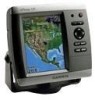
Garmin GPSMAP 535s - Marine GPS Receiver Support and Manuals
Get Help and Manuals for this Garmin item
View All Support Options Below
Free Garmin GPSMAP 535s manuals!
Problems with Garmin GPSMAP 535s?
Ask a Question
Free Garmin GPSMAP 535s manuals!
Problems with Garmin GPSMAP 535s?
Ask a Question
Popular Garmin GPSMAP 535s Manual Pages
Owner's Manual - Page 2

...as expressly provided herein, no part of this copyright notice and provided further that any revision hereto is strictly prohibited. Garmin reserves the right to change... updates and supplemental information concerning the use and operation of this manual or any unauthorized commercial distribution of this document is a registered trademark of Garmin. Garmin®, the Garmin logo, GPSMAP&#...
Owner's Manual - Page 3
...Chart," you should highlight Charts, and
Introduction
press SELECT. Introduction
This manual includes information for the following products:
GPSMAP® 430/430s GPSMAP 431/431s GPSMAP 530/530s GPSMAP 531/531s GPSMAP 540/540s GPSMAP 541/541s
GPSMAP 440/440s GPSMAP 441/441s GPSMAP 535/535s GPSMAP 536/536s GPSMAP 545/545s GPSMAP 546/546s
Tips and Shortcuts
• Press HOME from any screen...
Owner's Manual - Page 7
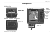
Unit Overview
Getting Started
GPSMAP 536/546
NMEA 2000 Power/Data External GPS antenna GPSMAP 531
GPSMAP 400/500 Series Owner's Manual
Getting Started
POWER/ BACKLIGHT RANGE (-/+) ROCKER MARK SELECT MENU HOME
SD card slot GPSMAP 546 shown
Owner's Manual - Page 10
... boat specifications for your boat (page 49). Press left or right on track to your manual setting. Refer to switch between modes.
GPSMAP 400/500 Series Owner's Manual
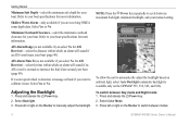
Note: Press the Power key repeatedly to manually adjust the backlight. Press and release the Power key. 2.
Minimum Overhead Clearance-select the minimum overhead clearance for AIS Receiver)-select...
Owner's Manual - Page 12
...because the GPS receiver is located on Simulator mode: 1. Press the card in simulator mode. Getting Started
For more information about GPS, visit the Garmin Web site at www.garmin.com/... System Information > Factory Settings.
2. To insert the SD card, open the access door and press the SD card in until it from the chartplotter.
GPSMAP 400/500 Series Owner's Manual To turn on the lower...
Owner's Manual - Page 18

...sets the high-resolution satellite images to highlight a tide-station icon ( ), and press SELECT.
Service Points-turns marine service...Review, and then select the item. Changing the Navigation Chart Settings
To change chart settings from the home screen, select Charts > Navigation Chart > MENU > Chart Setup...marine wind sensor.
12
GPSMAP 400/500 Series Owner's Manual Tides/Currents-turns tides ...
Owner's Manual - Page 47
... troubleshooting tool. Beeper/Display-select Beeper to set when the unit makes audible sounds. Select Display > Backlight to acquire satellites. • Speed Filter-select On, Off, or Auto.
GPS-view GPS satellites.
• Skyview-view the GPS satellite constellation. • WAAS/EGNOS-toggle WAAS (in North America) or EGNOS
GPSMAP 400/500 Series Owner's Manual
Configuring the Chartplotter...
Owner's Manual - Page 50

.../output format for serial port 1 to use when connecting your chartplotter to external NMEA devices, a computer, or other Garmin devices.
• Garmin Data Transfer-supports the input or output of Garmin-proprietary data for communicating with Garmin software.
• Garmin Remote Sonar Transfer (GPSMAP 430/440/530/540/535/545)-supports the input or output of standard 0183 data for serial...
Owner's Manual - Page 51
.../440/530/540/535/545 (including "s" models) are within a specified distance or time from the Home screen, select Configure > Alarms > Navigation.
To set a navigation alarm from a turn on your network.
Arrival-set the unit to arrival.
45 From the Home screen, select Configure > Communications >
NMEA 0183 Setup.
2. GPSMAP 400/500 Series Owner's Manual
Configuring the Chartplotter...
Owner's Manual - Page 56
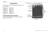
... frequency or beam width
Full Screen
Range
50
GPSMAP 400/500 Series Owner's Manual Using Sonar
Using Sonar
When connected to a transducer, the following chartplotters can be used as fishfinders:
GPSMAP 430s GPSMAP 431s GPSMAP 530s GPSMAP 531s GPSMAP 540s GPSMAP 541s
GPSMAP 440s GPSMAP 441s GPSMAP 535s GPSMAP 536s GPSMAP 545s GPSMAP 546s
Understanding the Full Screen
Select the Full...
Owner's Manual - Page 62

... using a Garmin NMEA 2000compatible VHF radio.
• Select Edit to enter the Maritime Mobile Service Identity (MMSI) number of the vessel, and press SELECT.
3. Complete one of the vessel, and select Done. Select Clear Report to view details about the call . Select Create Waypoint to set up to a DSC contact from the chartplotter. The...
Owner's Manual - Page 75
...65) cm
30 in. (75 cm)
38 in .
GPSMAP 430/430s GPSMAP 530/530s GPSMAP 540/540s
GPSMAP 440/440s GPSMAP 535/535s GPSMAP 545/545s
High-sensitivity, 14 parallel channel, WAAS-capable receiver. GPSMAP 536/536s GPSMAP 546/546s
Update Rate: once per second
GPSMAP 400/500 Series Owner's Manual 69
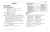
Appendix
Specifications
Physical Specifications Size : 400 Series: W × H × D: 5.7 in...
Owner's Manual - Page 76
GPS Accuracy: Position: Appendix
Acquisition Times: (Average acquisition times for a stationary receiver with a clear view of the sky.) GPSMAP 430/430s GPSMAP 440/440s GPSMAP 530/530s GPSMAP 535/535s GPSMAP 530/540s GPSMAP 535/545s
Warm:* Approximately 15 seconds Cold:** Approximately 45 seconds
GPSMAP 431/431s GPSMAP 441/441s GPSMAP 531/531s GPSMAP 541/541s
Warm:* Approximately 1 second Cold:**...
Owner's Manual - Page 78

Database Error-internal problem with an MMSI. Use a different number. Distress Call-a DSC distress call has been received.
No Waypoints/Routes/Tracks/User Waypoints Found-attempted to perform the function you requested.
Contact your configuration settings. Directory Memory is detected. Fish Alarm-a beep sounds (if enabled) when a fish is Full, Can't Create Entry-the DSC directory...
Owner's Manual - Page 83

...
detail 14 fish eye 3D 18 fishing 19 mariner's eye 3D 16 navigation 8 settings 12 cleaning the unit 74 Clear User Data 37 collision alarm 26, 49 colors, hazard 17 Color Scheme 53 Communications 44...
G
gain 54 Garmin Data Transfer 44 gauges, fuel 35 go to 27 GPS 5, 41, 70 Grid (North) 42 guide to 27
H
Hazard Colors 17 heading 42 Heading Line 14 Head Up 13
GPSMAP 400/500 Series Owner's Manual 77
Garmin GPSMAP 535s Reviews
We have not received any reviews for Garmin yet.