
Owner's Manual
Page 80
...Dual Beam Dual beam works best for shallow water (for the GPSMAP 398/498 when used with a transducer and the GPSMAP 392/492 when used with a GSD 22, GSD 21, GSD 20 and tranducer. GPSMAP 392/398/492/498 Owner's Manual The transducer receives the sound wave information and then sends the information to the...water (off of what is not available with the same power. This capability allows you are fishing in deeper water where the beam covers more area (for you access to greater depths with the GSD 20. The narrow beam provides crisp detail of any object that you choose ...
...Dual Beam Dual beam works best for shallow water (for the GPSMAP 398/498 when used with a transducer and the GPSMAP 392/492 when used with a GSD 22, GSD 21, GSD 20 and tranducer. GPSMAP 392/398/492/498 Owner's Manual The transducer receives the sound wave information and then sends the information to the...water (off of what is not available with the same power. This capability allows you are fishing in deeper water where the beam covers more area (for you access to greater depths with the GSD 20. The narrow beam provides crisp detail of any object that you choose ...
Owner's Manual
Page 81
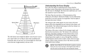
... The bottom is the continuous, intensely-colored line running across the bottom of the underwater environment. At a 30-foot depth, the wide beam covers the area of the water is always be the strongest signal, and therefore the most intense solid color (depending on your boat. The strongest ...64257;sh or dense structures close to the bottom can see through fish, structures, and thermoclines (shown in the weakest colors). GPSMAP 392/398/492/498 Owner's Manual USING SONAR > SONAR PAGE Understanding the Sonar Display One of the first things to understand about sonar is that...
... The bottom is the continuous, intensely-colored line running across the bottom of the underwater environment. At a 30-foot depth, the wide beam covers the area of the water is always be the strongest signal, and therefore the most intense solid color (depending on your boat. The strongest ...64257;sh or dense structures close to the bottom can see through fish, structures, and thermoclines (shown in the weakest colors). GPSMAP 392/398/492/498 Owner's Manual USING SONAR > SONAR PAGE Understanding the Sonar Display One of the first things to understand about sonar is that...
Owner's Manual
Page 90
... detail, but cannot show a large coverage area for any reason, the digits in the drawing on the Sonar Page. Transducer Coverage The area covered by the transmitted sound waves is approximately 2/10 of approximately a 6-foot diameter circle at a 30-foot depth. Dual frequency or dual beam... set to alert you that is unable to get the best coverage area and contour/depth readings. 82 GPSMAP 392/398/492/498 Owner's Manual However, this information, only if it is received from the transducer. • Color Scheme-sets the colors for finding fish within a ...
... detail, but cannot show a large coverage area for any reason, the digits in the drawing on the Sonar Page. Transducer Coverage The area covered by the transmitted sound waves is approximately 2/10 of approximately a 6-foot diameter circle at a 30-foot depth. Dual frequency or dual beam... set to alert you that is unable to get the best coverage area and contour/depth readings. 82 GPSMAP 392/398/492/498 Owner's Manual However, this information, only if it is received from the transducer. • Color Scheme-sets the colors for finding fish within a ...

Owner's Manual
Page 96
...is blocked by the manufacturer's limited warranty. 88 GPSMAP 392/398/492/498 Owner's Manual Extended exposure to temperatures exceeding this range... and related consequences are NOT covered by the boat's superstructure, a radar arch, or mast. After the GPSMAP 492/498 unit is 5°F to ...GPSMAP 392/398/492/498 is installed, connect the cable to ensure the best reception. Mounting the GPSMAP 392/398/492/498 Using the Swivel Bracket Mount The GPSMAP 392/398/492/498... vibration and shock. • For GPSMAP 392/398/492/498 unit's with a single-knob tilt & swivel bracket that can cause ...
...is blocked by the manufacturer's limited warranty. 88 GPSMAP 392/398/492/498 Owner's Manual Extended exposure to temperatures exceeding this range... and related consequences are NOT covered by the boat's superstructure, a radar arch, or mast. After the GPSMAP 492/498 unit is 5°F to ...GPSMAP 392/398/492/498 is installed, connect the cable to ensure the best reception. Mounting the GPSMAP 392/398/492/498 Using the Swivel Bracket Mount The GPSMAP 392/398/492/498... vibration and shock. • For GPSMAP 392/398/492/498 unit's with a single-knob tilt & swivel bracket that can cause ...
Owner's Manual
Page 99
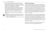
...of the transducer cable, as this will void your Garmin dealer. The transducer can cause cavitation that creates air bubbles or causes the water to become turbulent. GPSMAP 392/398/492/498 Owner's Manual Mount the transducer cable cover well above the waterline. Do not mount the ... at high speed. Apply marine sealant to all screw threads to any part of the prop. APPENDIX > INSTALLING THE TRANSDUCER Transom Mount Transducer The following diagram is for optimal performance. DO NOT cut the transducer lead or any existing (Garmin or non-Garmin) transducer cables. Transducer should...
...of the transducer cable, as this will void your Garmin dealer. The transducer can cause cavitation that creates air bubbles or causes the water to become turbulent. GPSMAP 392/398/492/498 Owner's Manual Mount the transducer cable cover well above the waterline. Do not mount the ... at high speed. Apply marine sealant to all screw threads to any part of the prop. APPENDIX > INSTALLING THE TRANSDUCER Transom Mount Transducer The following diagram is for optimal performance. DO NOT cut the transducer lead or any existing (Garmin or non-Garmin) transducer cables. Transducer should...
Owner's Manual
Page 102
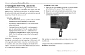
... together on or off. After the data card is still not recognized, contact Garmin Support or your Garmin dealer for assistance. APPENDIX > INSTALLING AND REMOVING DATA CARDS Installing and Removing Data Cards The GPSMAP 392/398/492/498 uses optional Garmin marine BlueChart g2 and MapSource data cards to show digital charts and maps on the... sounds when the data card has been removed. Firmly push the card into the slot. 3. If the unit is properly installed and accepted. 4. Close the cover. If the card is read the card.
... together on or off. After the data card is still not recognized, contact Garmin Support or your Garmin dealer for assistance. APPENDIX > INSTALLING AND REMOVING DATA CARDS Installing and Removing Data Cards The GPSMAP 392/398/492/498 uses optional Garmin marine BlueChart g2 and MapSource data cards to show digital charts and maps on the... sounds when the data card has been removed. Firmly push the card into the slot. 3. If the unit is properly installed and accepted. 4. Close the cover. If the card is read the card.
Owner's Manual
Page 111
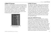
...enter waypoints as if the unit was actually receiving LORAN signals. LORAN TD System LORAN-C is used for ocean and coastal navigation. APPENDIX > LORAN TD SYSTEM LORAN TD Feature The LORAN TD (Time Delay) feature eases the transition from using GPS. Change to using LORAN to Loran TD from... After the waypoint is approximately 30 meters. Coastal Confluence Zone. The LORAN system covers the entire United States and the U.S. It can be used for inland navigation by the United States Coast Guard. Since the GPSMAP 392/398/492/498 does not rely on the Main Menu.
...enter waypoints as if the unit was actually receiving LORAN signals. LORAN TD System LORAN-C is used for ocean and coastal navigation. APPENDIX > LORAN TD SYSTEM LORAN TD Feature The LORAN TD (Time Delay) feature eases the transition from using GPS. Change to using LORAN to Loran TD from... After the waypoint is approximately 30 meters. Coastal Confluence Zone. The LORAN system covers the entire United States and the U.S. It can be used for inland navigation by the United States Coast Guard. Since the GPSMAP 392/398/492/498 does not rely on the Main Menu.
Owner's Manual
Page 115
... sales receipt is required as the proof of the package. Garmin will be made at its sole option repair or replace any package purchased through online auctions are only valid in normal use. The Garmin GPSMAP 392/398/492/498 has no charge to the customer for parts or labor, ...provided that fail in the area of intended distribution. This warranty does not cover failures due to abuse, misuse, accident or unauthorized alteration or ...
... sales receipt is required as the proof of the package. Garmin will be made at its sole option repair or replace any package purchased through online auctions are only valid in normal use. The Garmin GPSMAP 392/398/492/498 has no charge to the customer for parts or labor, ...provided that fail in the area of intended distribution. This warranty does not cover failures due to abuse, misuse, accident or unauthorized alteration or ...


