
Owner's Manual
Page 80
... top and angling out to use the sonar features. USING SONAR > SONAR PAGE USING SONAR This section covers the additional sonar options for the GPSMAP 398/498 when used with a transducer and the GPSMAP 392/492 when used with the same power. NOTE: You MUST have a transducer installed and connected to.../498 to see and interpret. Ultrascroll is determined by the beam width of what is very helpful if you to use the sonar features. The narrow beam provides crisp detail of the transducer and the water depth. The transducer receives the sound wave information and then sends the ...
... top and angling out to use the sonar features. USING SONAR > SONAR PAGE USING SONAR This section covers the additional sonar options for the GPSMAP 398/498 when used with a transducer and the GPSMAP 392/492 when used with the same power. NOTE: You MUST have a transducer installed and connected to.../498 to see and interpret. Ultrascroll is determined by the beam width of what is very helpful if you to use the sonar features. The narrow beam provides crisp detail of the transducer and the water depth. The transducer receives the sound wave information and then sends the ...
Owner's Manual
Page 81
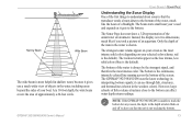
... scheme; The Sonar Page does not show a 3-D representation of approximately a 20-foot circle. The bottom is the default). NOTE: If the GPSMAP 392/398/492/498 is unable to understand about sonar is that the unit is not tracking the bottom. 73 Only the depth of the item in the...objects in the water, including areas beyond the sides of your boat. At a 30-foot depth, the wide beam covers the area of the underwater environment. The GPSMAP 392/398/492/498 uses the latest technology in interpreting bottom signals; The bottom of the water is shown. However, large schools of fi...
... scheme; The Sonar Page does not show a 3-D representation of approximately a 20-foot circle. The bottom is the default). NOTE: If the GPSMAP 392/398/492/498 is unable to understand about sonar is that the unit is not tracking the bottom. 73 Only the depth of the item in the...objects in the water, including areas beyond the sides of your boat. At a 30-foot depth, the wide beam covers the area of the underwater environment. The GPSMAP 392/398/492/498 uses the latest technology in interpreting bottom signals; The bottom of the water is shown. However, large schools of fi...
Owner's Manual
Page 90
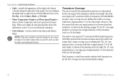
... scale to appear in one of the transducer and the water depth. Transducer Coverage The area covered by the cone angle of four different ways: as an Overlay, in the depth window fl... angle produces a coverage area of the water depth. When set to alert you that the unit is received from the transducer. • Color Scheme-sets the colors for finding fish within a... If the unit is unable to get the best coverage area and contour/depth readings. 82 GPSMAP 392/398/492/498 Owner's Manual The wide cone angles (40°) associated with the high frequencies (200 kHz...
... scale to appear in one of the transducer and the water depth. Transducer Coverage The area covered by the cone angle of four different ways: as an Overlay, in the depth window fl... angle produces a coverage area of the water depth. When set to alert you that the unit is received from the transducer. • Color Scheme-sets the colors for finding fish within a... If the unit is unable to get the best coverage area and contour/depth readings. 82 GPSMAP 392/398/492/498 Owner's Manual The wide cone angles (40°) associated with the high frequencies (200 kHz...

Owner's Manual
Page 96
...the antenna (external antenna only), power/data cables. • The mounting surface should be used for the GPSMAP 392/398/492/498 is installed, connect the cable to lock the cable into place. Route the cable to allow connection of... failure and related consequences are NOT covered by the boat's superstructure, a radar arch, or mast. Use the... operating conditions) can be at the nav station. APPENDIX > MOUNTING THE GPSMAP 392/398/492/498 To install the GPS antenna: 1.
...the antenna (external antenna only), power/data cables. • The mounting surface should be used for the GPSMAP 392/398/492/498 is installed, connect the cable to lock the cable into place. Route the cable to allow connection of... failure and related consequences are NOT covered by the boat's superstructure, a radar arch, or mast. Use the... operating conditions) can be at the nav station. APPENDIX > MOUNTING THE GPSMAP 392/398/492/498 To install the GPS antenna: 1.
Owner's Manual
Page 99
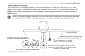
...cover well above the waterline. The transducer can cause cavitation that the transducer is in the path of the transducer cable, as this will void your Garmin dealer. Do not mount the transducer directly in clean (non-turbulent) water for mounting the transducer included with the GPSMAP 392/398/492/498...any part of the prop. Apply marine sealant to all screw threads to become turbulent. Make sure that creates air bubbles or causes the water to prevent water from your warranty. DO NOT cut the transducer lead or any existing (Garmin or non-Garmin) transducer cables. NOTE: DO ...
...cover well above the waterline. The transducer can cause cavitation that the transducer is in the path of the transducer cable, as this will void your Garmin dealer. Do not mount the transducer directly in clean (non-turbulent) water for mounting the transducer included with the GPSMAP 392/398/492/498...any part of the prop. Apply marine sealant to all screw threads to become turbulent. Make sure that creates air bubbles or causes the water to prevent water from your warranty. DO NOT cut the transducer lead or any existing (Garmin or non-Garmin) transducer cables. NOTE: DO ...
Owner's Manual
Page 102
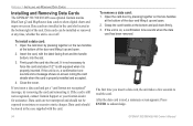
... a few seconds to read , a summary screen appears. APPENDIX > INSTALLING AND REMOVING DATA CARDS Installing and Removing Data Cards The GPSMAP 392/398/492/498 uses optional Garmin marine BlueChart g2 and MapSource data cards to show digital charts and maps on the two handles at the bottom of the unit. To... remove a data card: 1. Close the cover. The first time you insert a data card and get a "card format not recognized" ...
... a few seconds to read , a summary screen appears. APPENDIX > INSTALLING AND REMOVING DATA CARDS Installing and Removing Data Cards The GPSMAP 392/398/492/498 uses optional Garmin marine BlueChart g2 and MapSource data cards to show digital charts and maps on the two handles at the bottom of the unit. To... remove a data card: 1. Close the cover. The first time you insert a data card and get a "card format not recognized" ...
Owner's Manual
Page 111
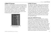
... stored in unit memory, it simulates the operation of a mariner, the system is used as TDs. From the perspective of a LORAN receiver. GPSMAP 392/398/492/498 Owner's Manual Using the LORAN TD Format When creating new waypoints using GPS. It can be used for those changes. If you must...States by recreational vehicles. When the unit is used as if the unit was actually receiving LORAN signals. Since the GPSMAP 392/398/492/498 does not rely on the Main Menu. The LORAN system covers the entire United States and the U.S. Position coordinates can show your position as a...
... stored in unit memory, it simulates the operation of a mariner, the system is used as TDs. From the perspective of a LORAN receiver. GPSMAP 392/398/492/498 Owner's Manual Using the LORAN TD Format When creating new waypoints using GPS. It can be used for those changes. If you must...States by recreational vehicles. When the unit is used as if the unit was actually receiving LORAN signals. Since the GPSMAP 392/398/492/498 does not rely on the Main Menu. The LORAN system covers the entire United States and the U.S. Position coordinates can show your position as a...
Owner's Manual
Page 115
...SO51 9DL UK Tel. 44/0870.8501241 Fax 44/0870.8501251 Online Auction Purchases: Products sold through an online auction. The Garmin GPSMAP 392/398/492/498 has no charge to the customer for parts or labor, provided that fail in normal use. THE WARRANTIES AND REMEDIES CONTAINED HEREIN...defects in materials or workmanship for one year from Garmin. Within this distributor provides local service for your local Garmin authorized dealer or call Garmin Product Support for shipping instructions and an RMA tracking number. This warranty does not cover failures due to repair or replace the unit ...
...SO51 9DL UK Tel. 44/0870.8501241 Fax 44/0870.8501251 Online Auction Purchases: Products sold through an online auction. The Garmin GPSMAP 392/398/492/498 has no charge to the customer for parts or labor, provided that fail in normal use. THE WARRANTIES AND REMEDIES CONTAINED HEREIN...defects in materials or workmanship for one year from Garmin. Within this distributor provides local service for your local Garmin authorized dealer or call Garmin Product Support for shipping instructions and an RMA tracking number. This warranty does not cover failures due to repair or replace the unit ...


