Installation Instructions
Page 20
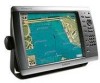
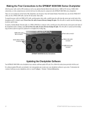
.... To determine the version of software on your chartplotter software is firmly seated. If a software update SD card is seated, turn the locking ring clockwise until it stops. Making the Final Connections to the GPSMAP 4000/5000 Series Chartplotter After the power cable and the GPS antenna (as well as any optional Garmin Marine Network devices, NMEA 0183...
.... To determine the version of software on your chartplotter software is firmly seated. If a software update SD card is seated, turn the locking ring clockwise until it stops. Making the Final Connections to the GPSMAP 4000/5000 Series Chartplotter After the power cable and the GPS antenna (as well as any optional Garmin Marine Network devices, NMEA 0183...
Installation Instructions
Page 24
For the latest free software updates (excluding map data) throughout the life of your Garmin products, visit the Garmin Web site at www.garmin.com. Liberty House, Hounsdown Business Park, Southampton, Hampshire, SO40 9LR UK Garmin Corporation No. 68, Jangshu 2nd Road, Shijr, Taipei County, Taiwan www.garmin.com Part Number 190-00779-02 Rev. August 2009 © 2009 Garmin Ltd. F Printed in Taiwan or its subsidiaries Garmin International, Inc. 1200 East 151st Street, Olathe, Kansas 66062, USA Garmin (Europe) Ltd.
For the latest free software updates (excluding map data) throughout the life of your Garmin products, visit the Garmin Web site at www.garmin.com. Liberty House, Hounsdown Business Park, Southampton, Hampshire, SO40 9LR UK Garmin Corporation No. 68, Jangshu 2nd Road, Shijr, Taipei County, Taiwan www.garmin.com Part Number 190-00779-02 Rev. August 2009 © 2009 Garmin Ltd. F Printed in Taiwan or its subsidiaries Garmin International, Inc. 1200 East 151st Street, Olathe, Kansas 66062, USA Garmin (Europe) Ltd.

Remote Instructions (Multilingual)
Page 1
... the warranty, warnings, cautions, and the software license agreement. July 2007 Garmin International, Inc. 1200 East 151st Street, Olathe, Kansas 66062, USA Garmin (Europe) Ltd. A Printed in accordance with GPSMAP 4000/5000 Series Chartplotters or its subsidiaries. ...GPS unit. • Consult the dealer or an experienced radio/TV technician for any interference received, including interference that is a trademark of Garmin Ltd. Refer to your authority to operate this document is subject to comply with Part 15 of the FCC interference limits for current updates...
... the warranty, warnings, cautions, and the software license agreement. July 2007 Garmin International, Inc. 1200 East 151st Street, Olathe, Kansas 66062, USA Garmin (Europe) Ltd. A Printed in accordance with GPSMAP 4000/5000 Series Chartplotters or its subsidiaries. ...GPS unit. • Consult the dealer or an experienced radio/TV technician for any interference received, including interference that is a trademark of Garmin Ltd. Refer to your authority to operate this document is subject to comply with Part 15 of the FCC interference limits for current updates...

Technical Reference for Garmin NMEA 2000 Products
Page 26
... angle filter: 1. To configure the wind angle offset if the menu option is not filtered. • On-select a lower number to update the display device less often, and help the gauge needle or wind speed number to adjust the filter settings. • Off-the wind speed...Select Generic Configuration to adjust for the difference in the wind angle. Tip: The angles are configured clockwise around the mast of software loaded on your Garmin marine instrument, the specific configuration options may not be displayed on the port side. While viewing the NMEA 2000 device information, select Config...
... angle filter: 1. To configure the wind angle offset if the menu option is not filtered. • On-select a lower number to update the display device less often, and help the gauge needle or wind speed number to adjust the filter settings. • Off-the wind speed...Select Generic Configuration to adjust for the difference in the wind angle. Tip: The angles are configured clockwise around the mast of software loaded on your Garmin marine instrument, the specific configuration options may not be displayed on the port side. While viewing the NMEA 2000 device information, select Config...
Technical Reference for Garmin NMEA 2000 Products
Page 30
For the latest free software updates (excluding map data) throughout the life of your Garmin products, visit the Garmin Web site at www.garmin.com. Liberty House, Hounsdown Business Park, Southampton, Hampshire, SO40 9RB UK Garmin Corporation No. 68, Jangshu 2nd Road, Shijr, Taipei County, Taiwan www.garmin.com Part Number 190-00891-00 Rev. or its subsidiaries Garmin International, Inc. 1200 East 151st Street, Olathe, Kansas 66062, USA Garmin (Europe) Ltd. B Printed in Taiwan March, 2009 © 2009 Garmin Ltd.
For the latest free software updates (excluding map data) throughout the life of your Garmin products, visit the Garmin Web site at www.garmin.com. Liberty House, Hounsdown Business Park, Southampton, Hampshire, SO40 9RB UK Garmin Corporation No. 68, Jangshu 2nd Road, Shijr, Taipei County, Taiwan www.garmin.com Part Number 190-00891-00 Rev. or its subsidiaries Garmin International, Inc. 1200 East 151st Street, Olathe, Kansas 66062, USA Garmin (Europe) Ltd. B Printed in Taiwan March, 2009 © 2009 Garmin Ltd.
Owner's Manual
Page 8
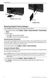
.... 1. Select Setup to update the system software or purchase additional map data information. The chartplotter does not track satellites in Simulator mode. Getting Started Getting Started Card label GPSMAP 4210 or 4212 Card label GPSMAP 4208 Restoring Original Factory Settings...GPSMAP 4000 Series Owner's Manual Select an option: • Select Yes to restore all factory settings. • Select No to navigate using Simulator mode because the GPS receiver is turned off the GPS receiver for use indoors or for practice. Viewing System Information You can view your chartplotter's software...
.... 1. Select Setup to update the system software or purchase additional map data information. The chartplotter does not track satellites in Simulator mode. Getting Started Getting Started Card label GPSMAP 4210 or 4212 Card label GPSMAP 4208 Restoring Original Factory Settings...GPSMAP 4000 Series Owner's Manual Select an option: • Select Yes to restore all factory settings. • Select No to navigate using Simulator mode because the GPS receiver is turned off the GPS receiver for use indoors or for practice. Viewing System Information You can view your chartplotter's software...
Owner's Manual
Page 34
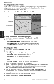
... select Information > User Data. 2. Check your chartplotter to allow it to place a file on the computer by clicking Help > Check for Software Updates, or check the Garmin Web site at the specified date and time. From the Home screen, select Information > Tides/Currents > Celestial. 2. This must be done ... card. 2. Moon position Sun position Sky view window Overhead Horizon Viewing Information To change the date or time, or to Device. 30 GPSMAP 4000 Series Owner's Manual Insert the SD card into your MapSource version on the SD card. Insert an SD card into an SD card...
... select Information > User Data. 2. Check your chartplotter to allow it to place a file on the computer by clicking Help > Check for Software Updates, or check the Garmin Web site at the specified date and time. From the Home screen, select Information > Tides/Currents > Celestial. 2. This must be done ... card. 2. Moon position Sun position Sky view window Overhead Horizon Viewing Information To change the date or time, or to Device. 30 GPSMAP 4000 Series Owner's Manual Insert the SD card into your MapSource version on the SD card. Insert an SD card into an SD card...
Owner's Manual
Page 73
... route. Ending position not within the specified safe depth. Auto-guidance unable to calculate route. Boat is already in the wiring to the GPS 17 antenna. Can't Read Voltages That High, Limited To Top Of Range-entering a battery alarm voltage higher than the chartplotter can read ...BlueChart g2 Vision) automatic guidance cannot calculate the route; Starting position not within the specified safe depth. If wheel is needed. Software Update Required-a software update is clear, calibrate again and increase speed. GPSMAP 4000 Series Owner's Manual 69 Contact product support.
... route. Ending position not within the specified safe depth. Auto-guidance unable to calculate route. Boat is already in the wiring to the GPS 17 antenna. Can't Read Voltages That High, Limited To Top Of Range-entering a battery alarm voltage higher than the chartplotter can read ...BlueChart g2 Vision) automatic guidance cannot calculate the route; Starting position not within the specified safe depth. If wheel is needed. Software Update Required-a software update is clear, calibrate again and increase speed. GPSMAP 4000 Series Owner's Manual 69 Contact product support.
Owner's Manual
Page 74
...that requires a software update. Flood Warning Alarm-(XM WX weather) there is a weather warning in effect. Enter a number between (0 - 252)-invalid NMEA 2000 Device instance. Marine Weather Warning-(XM WX weather) there is a flood warning effective. GPS Service Incompatible. ... a user-defined distance. DSC Position Report Received From -a position report has been received by the NMEA 2000 network. Contact product support for assistance updating your chartplotter software. Software Update Required-a GPS service software update is needed. Check the network and the ...
...that requires a software update. Flood Warning Alarm-(XM WX weather) there is a weather warning in effect. Enter a number between (0 - 252)-invalid NMEA 2000 Device instance. Marine Weather Warning-(XM WX weather) there is a flood warning effective. GPS Service Incompatible. ... a user-defined distance. DSC Position Report Received From -a position report has been received by the NMEA 2000 network. Contact product support for assistance updating your chartplotter software. Software Update Required-a GPS service software update is needed. Check the network and the ...
Owner's Manual
Page 75
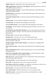
... a user data transfer. No User Waypoints Found-no proximity waypoints found while attempting a user data transfer. Radar Service Incompatible. Software Update Required-a radar software update is overlapping another name. Route Memory is Full, Can't Create Route-the chartplotter's route memory as a whole is full, ...to help diagnose the error. Radar Service Lost-(radar) the chartplotter has lost differential GPS reception (WAAS). Off Course Alarm-the boat has left the user-defined course. GPSMAP 4000 Series Owner's Manual 71 Some of the route have been discarded. Route Truncated-...
... a user data transfer. No User Waypoints Found-no proximity waypoints found while attempting a user data transfer. Radar Service Incompatible. Software Update Required-a radar software update is overlapping another name. Route Memory is Full, Can't Create Route-the chartplotter's route memory as a whole is full, ...to help diagnose the error. Radar Service Lost-(radar) the chartplotter has lost differential GPS reception (WAAS). Off Course Alarm-the boat has left the user-defined course. GPSMAP 4000 Series Owner's Manual 71 Some of the route have been discarded. Route Truncated-...
Owner's Manual
Page 76
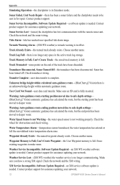
... Can't Create Waypoint-the User Waypoint memory is complete. Choose another name. Sonar has been turned off. Software Update Required-an XM service software update is fully inserted. Track Truncated-some points on the end of the track have a strong XM signal. Weather...route. Waypoint Already Exists-the named waypoint already exists. Erase existing waypoints to be sent in for assistance updating your network. 72 GPSMAP 4000 Series Owner's Manual Appendix Simulating Operation-the chartplotter is an unknown bridge height within calculated auto-guidance...
... Can't Create Waypoint-the User Waypoint memory is complete. Choose another name. Sonar has been turned off. Software Update Required-an XM service software update is fully inserted. Track Truncated-some points on the end of the track have a strong XM signal. Weather...route. Waypoint Already Exists-the named waypoint already exists. Erase existing waypoints to be sent in for assistance updating your network. 72 GPSMAP 4000 Series Owner's Manual Appendix Simulating Operation-the chartplotter is an unknown bridge height within calculated auto-guidance...
Owner's Manual
Page 84
or its subsidiaries Garmin International, Inc. 1200 East 151st Street, Olathe, Kansas 66062, USA Garmin (Europe) Ltd. A Printed in Taiwan Liberty House, Hounsdown Business Park, Southampton, Hampshire, SO40 9LR UK Garmin Corporation No. 68, Jangshu 2nd Road, Shijr, Taipei County, Taiwan www.garmin.com April 2009 Part Number 190-01078-00 Rev. For the latest free software updates (excluding map data) throughout the life of your Garmin products, visit the Garmin Web site at www.garmin.com. © 2009 Garmin Ltd.
or its subsidiaries Garmin International, Inc. 1200 East 151st Street, Olathe, Kansas 66062, USA Garmin (Europe) Ltd. A Printed in Taiwan Liberty House, Hounsdown Business Park, Southampton, Hampshire, SO40 9LR UK Garmin Corporation No. 68, Jangshu 2nd Road, Shijr, Taipei County, Taiwan www.garmin.com April 2009 Part Number 190-01078-00 Rev. For the latest free software updates (excluding map data) throughout the life of your Garmin products, visit the Garmin Web site at www.garmin.com. © 2009 Garmin Ltd.


