Garmin GPSMAP 4212 Support Question
Garmin GPSMAP 4212 Support Question
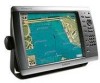
Find answers below for this question about Garmin GPSMAP 4212 - Marine GPS Receiver.Need a Garmin GPSMAP 4212 manual? We have 8 online manuals for this item!
Question posted by ttaska on June 10th, 2012
Rosepoint Software
Is this unit compatible with rosepoint software?
Current Answers
Related Garmin GPSMAP 4212 Manual Pages
Installation Instructions - Page 1
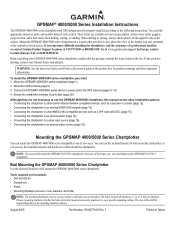
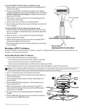
...mount the GPSMAP 4000/5000 series chartplotter. at most marine dealers. If any parts are not included. Mount the GPS antenna (... GPSMAP 4000/5000 chartplotter, this manual covers other installation options: • Connecting the chartplotter to other Garmin Marine Network compatible ...the chartplotter software is on the mounting hardware chosen. Note: You cannot bail mount the GPSMAP 5015/...
Installation Instructions - Page 5
...Radar
3 ft. (1 m) VHF Radio Antenna
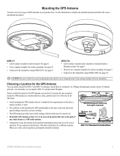
GPS 17x Placement Considerations
GPSMAP 4000/5000 Series Installation Instructions
See page 10. To ensure the best reception, mount the GPS antenna in a location that has a clear,... mast.
• On a sailboat, avoid mounting the GPS antenna high on your product box.
OD pipe-threaded-pole marine mount (14 threads- EMI
Better
Best Good
SS BARNETT
...
Installation Instructions - Page 6
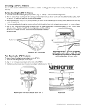
...secure the pole-mount adapter to the GPS 17: 1.
Mounting holes
M4 screws and washers
Bottom of the unit.
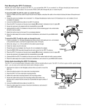
Surface Mounting the GPS 17 Antenna
1. If
you plan ... drill bit.
4.
Attaching the Pole-mount Adapter to the GPS 17
Align Notch GPSMAP 4000/5000 Series Installation Instructions OD pipe-threaded-pole marine mount (14 threads per inch-not
included).
Mark the center ...
Installation Instructions - Page 7
...using the drill bit table (page 4), and drill the three pilot holes. OD pipe-threaded-pole marine mount (14 threads-per inch-not included). Use a 1 in. (25 mm) hole saw ...the appropriate drill bit for the cable to your NMEA 2000 network.
➋
GPS 17x antenna
➌
Rubber gasket
GPSMAP 4000/5000 Series Installation Instructions
Mounting
9. Route the cable away from sources ...
Installation Instructions - Page 8
... drop cable to the GPS 17x.
7. Route the cable away from sources of electronic interference, and connect it to the GPS 17x antenna. Fasten the marine mount to your NMEA ... pads
Mounting surface
GPS 17x antenna
Under-deck mounting bracket
GPSMAP 4000/5000 Series Installation Instructions You can run outside the pole. Vertical cable slot
6. Place the GPS 17x antenna on ...
Installation Instructions - Page 9
....
Using a 1 1/4 in ) >
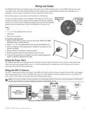
White (data out)
>
Wiring the GPSMAP 4000/5000 Unit and the GPS 17
>
GPS 17 GPS/WAAS
Sensor
GPSMAP 4000/5000 Series Installation Instructions
Solder all connections and seal them with a power cable, a NMEA 2000 drop cable, a 19-pin NMEA 0183 data cable, and a 17-pin Marine Video cable.
Purchase additional
grommets from your Garmin...
Installation Instructions - Page 12
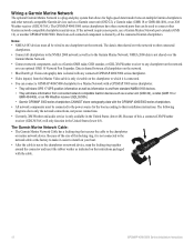
... used to connect other network-compatible Garmin devices such as to the Garmin Marine Network. The GPSMAP 4000/5000 series chartplotters have three network ports that can connect a GPSMAP 4000/5000 chartplotter to a Marine Network with a GPSMAP 3000 series chartplotter: • They will share GPS 17 GPS position information as well as a sonar unit (GSD 22), a radar (GMR 18...
Installation Instructions - Page 14
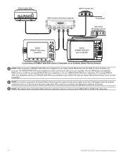
... radar
GSD 22 sounder unit
xxxx
GMS 10 marine network port expander
xxxxxxxxxxxxxxxxxxxxxxx
To transducer
GDL 30/30A XM weather receiver
Garmin GPSMAP 3000 series
chartplotter
Garmin GPSMAP 4000/5000
series chartplotter
Connecting a GPSMAP 4000/5000 Series Chartplotter to an Existing Garmin Marine Network
Note: When connecting a GPSMAP 4000/5000 series chartplotter to an existing Garmin...
Installation Instructions - Page 20
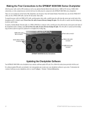
...to the GPSMAP 4000/5000 Series Chartplotter
After the power cable and the GPS antenna (as well as any optional Garmin Marine Network devices...Marine Network connectors
Marine video cable connector
NMEA 0183 cable connector
GPSMAP 4000/5000 Series Connectors
Updating the Chartplotter Software
Your GPSMAP 4000/5000 series chartplotter may contain a software update SD card. To attach a Garmin Marine...
Remote Instructions (Multilingual) - Page 1

...off and on a different circuit from the GPS unit. • Consult the dealer or an experienced...the warranty, warnings, cautions, and the software license agreement. Refer to your authority to...(2) this device must accept any interference received, including interference that interference will not ...used without obligation to comply with GPSMAP 4000/5000 Series Chartplotters
Garmin ...
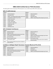
Technical Reference for Garmin NMEA 2000 Products - Page 4
...-Certified Display Device PGN Information...13
GPSMAP 4000/5000 Series Chartplotters...13 GMI 10...14
NMEA 2000-Certified Sensor PGN Information...15 GPS 17x (GPS Antenna)...15 GFS 10 (Garmin Fuel... With a Garmin Chartplotter or Marine Instrument...19 Changing the Fuel Economy Source...19 Using Fuel-Level Information With a Garmin Chartplotter or Marine Instrument...19 Configuring Engine and Tank...
Technical Reference for Garmin NMEA 2000 Products - Page 19
...Claim NMEA - Dynamic
Trip Parameters, Engine Fluid Level (when calibrated using a Garmin chartplotter or marine instrument)
ISO Acknowledgement ISO Request ISO Address Claim NMEA-Command/Request/Acknowledge Group Function Engine Parameters -
GPS 17x (GPS Antenna)
Transmit
Receive
059392 060928 126208 126464 126992 126996 129025 129026 129029 129539 129540
ISO Acknowledgment ISO Address...
Technical Reference for Garmin NMEA 2000 Products - Page 23
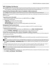
...Level Information With a Garmin Chartplotter or Marine Instrument To receive fuel-level information, connect the wiring ...unit to all available fuel-level instruments and sources. Technical Reference for fuel-level information. Changing the Fuel Economy Source The Garmin chartplotter or marine...10 is used on your boat; Select either GPS Speed or Water Speed to calculate fuel economy.
...
Owner's Manual - Page 4
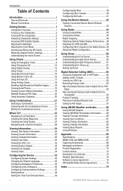
... 2 Initializing Chartplotter Settings 2 Acquiring GPS Satellite Signals 3 Adjusting the Backlight ...BlueChart g2 Vision 15 Using Mariner's Eye 3D 16 Using ... Preferences 35 Configuring Units of Measure 36...Viewing the DSC List 55 Receiving Distress Calls 55 Man-Overboard...Software License Agreement 74 XM Satellite Radio Service Agreement 74
Index 75
GPSMAP 4000 Series Owner's Manual
Owner's Manual - Page 8
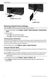
... restoring factory settings. Getting Started
Getting Started
Card label
GPSMAP 4210 or 4212
Card label GPSMAP 4208
Restoring Original Factory Settings
Caution: This procedure deletes ...mode because the GPS receiver is turned off the GPS receiver for use indoors or for practice. Viewing System Information You can view your chartplotter's software version, basemap version, unit ID number,...
Owner's Manual - Page 19
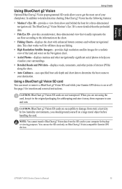
... specified boat safe depth and chart data to determine the best course to your chartplotter.
GPSMAP 4000 Series Owner's Manual 15 In addition to the information on BlueChart g2 Vision-compatible Garmin GPS devices. The BlueChart g2 Vision Mariner's Eye 3D is on a large metal object before handling the card. caution: BlueChart g2 Vision...
Owner's Manual - Page 42
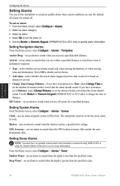
... or Numeric Keypad (GPSMAP 4210 or 4212 only) to sound when you exceed a specified drift distance.
The chartplotter must have an optional sonar module and a transducer connected using NMEA 0183 or using the system (GPS) clock. From the Home screen, select Configure > Alarms > Sonar. Deep Water-set an alarm to receive sonar information. To...
Owner's Manual - Page 46
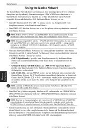
... quickly and easily. Sonar data is shared by all chartplotters on your GPSMAP 4000 series chartplotter to a Garmin Marine Network to receive data from an SD card inserted in the Marine Network or to a GMS 10 Marine Network Port Expander, with every other Marine Networkcompatible devices and chartplotters. Connect the GDL 30A (the GDL 30 device...
Owner's Manual - Page 47
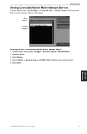
... or Numeric Keypad (GPSMAP 4210 or 4212 only) to a Garmin Marine Network device: 1. From the Home screen, select Configure > Communications > Marine Network. 2. Select Review. 4. Select Done. Marine Network
GPSMAP 4000 Series Owner's Manual
43 Marine Network
Viewing Connected Garmin Marine Network Devices
From the Home screen, select Configure > Communications > Marine Network. Select the...
Owner's Manual - Page 74
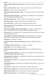
...) the chartplotter has lost communications with the heading sensor. Marine Weather Warning-(XM WX weather) there is needed. GPS Antenna Has Lost Its Stored Settings-The GPS antenna's memory has been cleared. Check the network and the antenna wiring.
Invalid System Instance.
Software Update Required-a GPS service software update is a weather warning in effect.
Default value...
Similar Questions

What Is Error Code 1 On Garmin Radome Radar?
(Posted by ultraypm 11 months ago)

How Do I Go Into Simulation Mode On A Garmin Marine Gps Modle741xs
how do I use simulation mode on a garmin 741xs marine ver
how do I use simulation mode on a garmin 741xs marine ver
(Posted by Curthupp 6 years ago)


How To Install A Garmin Gfs 10 Garmin 4212 Gps
(Posted by ezpras 10 years ago)

System Update From Sd Card Not Executed
I created a SD card with system software update data, inserted the card in my GPSMAP 420s unit, and ...
I created a SD card with system software update data, inserted the card in my GPSMAP 420s unit, and ...
(Posted by zdenbenes 12 years ago)