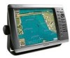
Garmin GPSMAP 4212 Support Question
Garmin GPSMAP 4212 Support Question
Find answers below for this question about Garmin GPSMAP 4212 - Marine GPS Receiver.Need a Garmin GPSMAP 4212 manual? We have 8 online manuals for this item!
Question posted by Dbraithwaite on January 26th, 2015
What Is Error Code 1?
The person who posted this question about this Garmin product did not include a detailed explanation. Please use the "Request More Information" button to the right if more details would help you to answer this question.
Current Answers
Answer #1: Posted by Autodiy on January 26th, 2015 1:16 PM
Autodiy

Member since:
May 23rd, 2014 Points: 815,136

Member since:
May 23rd, 2014 Points: 815,136
the error code is explained on the link below and it is also solved there.
http://www.thehulltruth.com/marine-electronics-forum/224106-garmin-radar-error-code-help.html
Www.autodiy.co.za
Related Garmin GPSMAP 4212 Manual Pages
Installation Instructions - Page 1
... Series Installation Instructions
The GPSMAP 4000/5000 series chartplotter and GPS antenna must : 1. These items are available at 913/397.8200 or 800/800.1020. Always wear safety goggles, ear protection, and a dust mask when drilling, cutting, or sanding. or contact Garmin Product Support by phone at most marine dealers. In Europe, contact...
Installation Instructions - Page 5
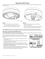
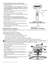
...GPS 17x Placement Considerations
GPSMAP 4000/5000 Series Installation Instructions
See page 23.
• Connects to water level. Choosing a Location for the GPS Antenna
You can surface mount the GPS 17 and GPS ...mast.
• On a sailboat, avoid mounting the GPS antenna high on your chartplotter.
OD pipe-threaded-pole marine mount (14 threads- Select a suitable location for correct...
Installation Instructions - Page 6
... deeper than 8 mm. Mounting holes
M4 screws and washers
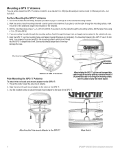
Bottom of each mounting hole with marine sealant. To attach the enclosed pole-mount adapter to the GPS 17
Align Notch GPSMAP 4000/5000 Series Installation Instructions If you can surface mount the GPS 17 antenna or install it through the larger hole, and apply...
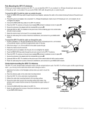
Installation Instructions - Page 7
...: 1. OD pipe-threaded-pole marine mount (14 threads
per inch-not included).
Use the included M4 screws to attach the surface-mount bracket to the boat .
4. Mounting
9. Fasten the pole mount to the boat if it to your NMEA 2000 network.
➋
GPS 17x antenna
➌
Rubber gasket
GPSMAP 4000/5000 Series Installation...
Installation Instructions - Page 8
... electronic interference, and connect it to the mounting surface with a marine sealant.
9. Adhesive pads
Mounting surface
GPS 17x antenna
Under-deck mounting bracket
GPSMAP 4000/5000 Series Installation Instructions Secure the antenna to lock it in place ➋.
7. OD pipe-threaded-pole marine mount (14 threads per inch-not included)
in the under a fiberglass...
Installation Instructions - Page 9
... around the cable.
6.
Tools
• Drill
• 1 1/4 in ) >
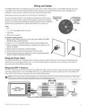
White (data out)
>
Wiring the GPSMAP 4000/5000 Unit and the GPS 17
>
GPS 17 GPS/WAAS
Sensor
GPSMAP 4000/5000 Series Installation Instructions
Apply marine sealant, as needed .
4.
Solder all connections and seal them with a power cable, a NMEA 2000 drop cable, a 19-pin NMEA 0183 data cable...
Installation Instructions - Page 12
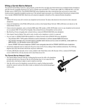
... connect a GPSMAP 4000/5000 chartplotter to a Marine Network with a GPSMAP 3000 series chartplotter: • They will share GPS 17 GPS position information as well as information to any connected GPSMAP 4000/5000 series chartplotter.
• Video input(s) from connected network compatible Garmin devices such as a Garmin GMR radar, GSD sounder, or GDL XM Weather receiver to and...
Installation Instructions - Page 14
.... Wire the GPS antenna and additional NMEA devices to an existing Garmin Marine Network, the GMS 10 can be connected to the appropriate installation instructions. Garmin marine radar
GSD 22 sounder unit
xxxx
GMS 10 marine network port expander
xxxxxxxxxxxxxxxxxxxxxxx
To transducer
GDL 30/30A XM weather receiver
Garmin GPSMAP 3000 series
chartplotter
Garmin GPSMAP 4000/5000...
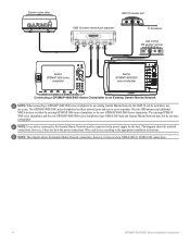
Installation Instructions - Page 20
... are wired to the boat, the cables must be connected to the GPSMAP 4000/5000 series chartplotter.
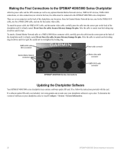
Making the Final Connections to the GPSMAP 4000/5000 Series Chartplotter
After the power cable and the GPS antenna (as well as any optional Garmin Marine Network devices, NMEA 0183 devices, NMEA 2000 connections, or video connections...
Technical Reference for Garmin NMEA 2000 Products - Page 4
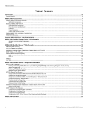
...-Certified Display Device PGN Information...13
GPSMAP 4000/5000 Series Chartplotters...13 GMI 10...14
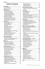
NMEA 2000-Certified Sensor PGN Information...15 GPS 17x (GPS Antenna)...15 GFS 10 (Garmin Fuel... With a Garmin Chartplotter or Marine Instrument...19 Changing the Fuel Economy Source...19 Using Fuel-Level Information With a Garmin Chartplotter or Marine Instrument...19 Configuring Engine and Tank...
Technical Reference for Garmin NMEA 2000 Products - Page 19
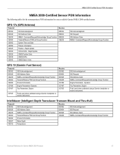
...Command/Request/Acknowledge Group Function Transmit/Receive PGN List Group Function System Time and Date Product Information Position - GPS 17x (GPS Antenna)
Transmit
Receive
059392 060928 126208 126464 126992 ...Trip Parameters, Engine Fluid Level (when calibrated using a Garmin chartplotter or marine instrument)
ISO Acknowledgement ISO Request ISO Address Claim NMEA-Command/Request/Acknowledge...
Technical Reference for Garmin NMEA 2000 Products - Page 23
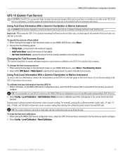
... to the fuel tank you want to
configure. Choose from the GFS 10: 1.
Select either GPS Speed or Water Speed to specify which speed sensor is used on your NMEA 2000 device, select...select Menu > Fuel Economy Source. 2. Using Fuel-Level Information With a Garmin Chartplotter or Marine Instrument To receive fuel-level information, connect the wiring harness on the GFS 10 to the fuel gauge or ...
Owner's Manual - Page 4
... Turning Off the Chartplotter 2 Initializing Chartplotter Settings 2 Acquiring GPS Satellite Signals 3 Adjusting the Backlight 3 Adjusting the Color ...Using Tracks 13 Using BlueChart g2 Vision 15 Using Mariner's Eye 3D 16 Using Fish Eye 3D 17 ...a DSC Contact 54 Viewing the DSC List 55 Receiving Distress Calls 55 Man-Overboard Distress Calls Initiated from...GPSMAP 4000 Series Owner's Manual
Owner's Manual - Page 19
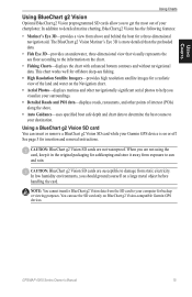
.... Note: You cannot transfer BlueChart g2 Vision data from the SD card to your Garmin GPS device is more detailed than the preloaded data. • Fish Eye 3D-provides an underwater...; Mariner's Eye 3D-provides a view from exposure to help you are not using the card, keep it in the original packaging for backup or viewing purposes. In addition to your chartplotter. GPSMAP 4000...
Owner's Manual - Page 39
... Demo.)
Auto Power Up (GPSMAP 4210 only)-turn Auto Power Up On or Off. Simulator-turn in a route that you transition to retrieve data about the marine network. Radar Diagnostics (if... and so on whenever power is applied, unless the chartplotter is provided as a troubleshooting tool; GPS-view GPS satellites. The event log displays a list of networked devices (page 42), and display the event ...
Owner's Manual - Page 42
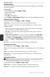
... the clock alarm to work. Use the Rocker or Numeric Keypad (GPSMAP 4210 or 4212 only) to sound when the GPS location accuracy falls outside the userdetermined value.
Off Course-set an alarm...are turned off course by a specified distance. Select On to receive sonar information. Clock-sets an alarm using the Garmin Marine Network to turn or destination waypoint.
• Type-select ...
Owner's Manual - Page 46
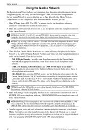
... XM WX weather and XM Radio data when connected to receive data from one GPSMAP 4000 or GPSMAP 5000 series chartplotter with every connected GPSMAP 4000 and GPSMAP 5000 series chartplotter. The station can connect your GPSMAP 4000 series chartplotter to a Garmin Marine Network to the Garmin Marine Network. The GDL 30/30A functions only when used in...
Owner's Manual - Page 47
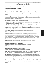
... the device. 5. From the Home screen, select Configure > Communications > Marine Network. 2. Select Done. Use the Rocker or Numeric Keypad (GPSMAP 4210 or 4212 only) to a Garmin Marine Network device: 1. Marine Network
GPSMAP 4000 Series Owner's Manual
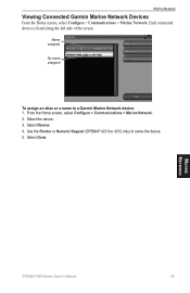
43 Select the device. 3.
Marine Network
Viewing Connected Garmin Marine Network Devices
From the Home screen, select Configure...
Owner's Manual - Page 74
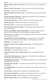
...GPS Service Incompatible.
GPS Service Lost-the chartplotter has lost communications with the remote GPS unit.
Invalid MMSI-an invalid DSC MMSI was entered.
Check wiring.
Map Format Is Not Supported-a map format on a preprogrammed SD card is a weather warning in effect. Marine... Received From -a position report has been received by the DSC module. GPS Accuracy Alarm-the GPS ...
Owner's Manual - Page 75
...GPSMAP 4000 Series Owner's Manual 71
No Tracks Found-no tracks found while attempting a user data transfer. Erase existing proximity waypoints to help diagnose the error. Radar Needs Repair Error Code... chartplotter can be created.
Radar Service Lost-(radar) the chartplotter has lost differential GPS reception (WAAS). Route Memory is Full, Can't Create Route-the chartplotter's route...
Similar Questions

What Is Error Code 1 On Garmin Radome Radar?
(Posted by ultraypm 10 months ago)


How To Install A Garmin Gfs 10 Garmin 4212 Gps
(Posted by ezpras 10 years ago)

My Garmin Radar Says Error Code 0 When I Boot It Up. How Can I Fix This Problem
(Posted by Exgold 11 years ago)

Problem With Gpsmap 3010c
When its time to transmit a massage ERROR CODE 0 appear and theirs no transmission
When its time to transmit a massage ERROR CODE 0 appear and theirs no transmission
(Posted by njfe12 14 years ago)