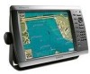
Garmin GPSMAP 4212 Support Question
Garmin GPSMAP 4212 Support Question
Find answers below for this question about Garmin GPSMAP 4212 - Marine GPS Receiver.Need a Garmin GPSMAP 4212 manual? We have 8 online manuals for this item!
Question posted by Exgold on April 12th, 2013
My Garmin Radar Says Error Code 0 When I Boot It Up. How Can I Fix This Problem
The person who posted this question about this Garmin product did not include a detailed explanation. Please use the "Request More Information" button to the right if more details would help you to answer this question.
Current Answers
Related Garmin GPSMAP 4212 Manual Pages
Declaration of Conformity - Page 1
...Council Directive: Standard to the above Directives
Paul Morrow Quality Manager GARMIN (Europe) Ltd
Date: 16th June 2007
GARMIN (Europe) Ltd Liberty House, Hounsdown Business Park, Southampton, Hampshire, SO40 9RB, U.K.
Marine Navigation Equipment (Global Positioning System Receiver)
GPSMAP 4XXX SERIES GPSMAP 5XXX SERIES
The undersigned does hereby declare that the equipment complies...
Installation Instructions - Page 1
...GPSMAP® 4000/5000 Series Installation Instructions
The GPSMAP 4000/5000 series chartplotter and GPS...GPSMAP 4000/5000 series chartplotters one of the surface. Mounting the GPSMAP 4000/5000 Series Chartplotter
You can use the GPSMAP 4000/5000 chartplotter, this manual covers other installation options: • Connecting the chartplotter to other Garmin Marine...sounder or a radar (page 12)....
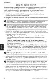
Installation Instructions - Page 12
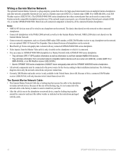
.... The Garmin Marine Network Cable: • The Garmin Marine Network Cable has a locking ring that can connect a GPSMAP 4000/5000 chartplotter to a Marine Network with a GPSMAP 3000 series chartplotter: • They will share GPS 17 GPS position information as well as a sonar unit (GSD 22), a radar (GMR 18 or GMR 404/406), or an XM Weather receiver (GDL30/30A). • Garmin GPSMAP 3000...
Installation Instructions - Page 13
... Instructions
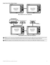
13 Note: These diagrams show the network connections; These diagrams show the Garmin Marine Network connections; Sample Garmin Marine Network Setups:
Garmin GPSMAP 4000/5000 series
chartplotter
Garmin GPSMAP 4000/5000 series
chartplotter
Marine Network with Two Chartplotters
Garmin marine radar
GDL 30/30A XM weather unit
xxxx
GSD 22 sounder unit
xxxxxxxxxxxxxxxxxxxxxxx
To...
Installation Instructions - Page 14
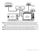
...: This diagram shows the Garmin Marine Network connections; Garmin marine radar
GSD 22 sounder unit
xxxx
GMS 10 marine network port expander
xxxxxxxxxxxxxxxxxxxxxxx
To transducer
GDL 30/30A XM weather receiver
Garmin GPSMAP 3000 series
chartplotter
Garmin GPSMAP 4000/5000
series chartplotter
Connecting a GPSMAP 4000/5000 Series Chartplotter to an Existing Garmin Marine Network
Note: When...
Technical Reference for Garmin NMEA 2000 Products - Page 17
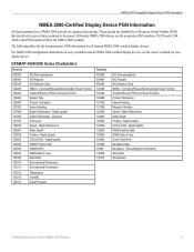
... Position Data GNSS DOPs GNSS Sats in View Cross Track Error Navigation Data Navigation - Rapid Update COG & SOG -
Rapid Update Engine Parameters - All the other PGN numbers follow the NMEA 2000 standard.
These groups are organized into groups. GPSMAP 4000/5000 Series Chartplotters
Receive
059392 059904 060928 126208 126464 126992 126996 127250 127488...
Owner's Manual - Page 4
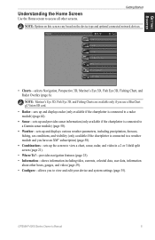
...Chartplotter Settings 2 Acquiring GPS Satellite Signals 3 ...Radar Overlay 13 Using Tracks 13 Using BlueChart g2 Vision 15 Using Mariner... a Garmin Autopilot...Marine Network 42 Viewing Connected Garmin Marine Network Devices 43
Using Radar 44 Using Cruising Mode 45 Using Sentry Mode 45 Radar Targeting 46 Obtaining Optimal Radar...List 55 Receiving Distress Calls ...Garmin 73 Declaration of Conformity...
Owner's Manual - Page 9
GPSMAP 4000 Series Owner's Manual
Note: Mariner's Eye 3D, Fish Eye 3D, and Fishing Charts are available only if you use a BlueChart g2 Vision SD card.
• Radar-sets up and displays radar (only available if the chartplotter is connected to a radar module) (page 44).
• Sonar-sets up and provides sonar information (only available if...
Owner's Manual - Page 11
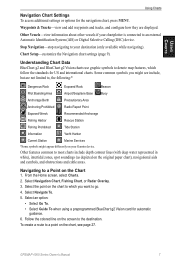
...Information
Yacht Harbor
Current Station
Marine Services
*Some symbols might appear differently on the Chart
1. Select Navigation Chart, Fishing Chart, or Radar Overlay. 3.
Understanding Chart...is connected to your Garmin device. Stop Navigation-stop navigating to an external Automatic Identification System (AIS) or Digital Selective Calling (DSC) device.
GPSMAP 4000 Series Owner's ...
Owner's Manual - Page 17
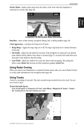
... you connect your chartplotter to an optional Garmin marine radar, you to overlay radar information on the Navigation chart (page 44). If the chartplotter is connected to a marine radar (page 44).
Using Tracks
A track is connected to an optional
sonar module and the shallow water alarm is the active track. GPSMAP 4000 Series Owner's Manual 13
Using...
Owner's Manual - Page 39
... Garmin Product Support representative may ask you to use this to toggle between Water (from a water-speed sensor) and GPS (from the calculated GPS speed... automatically will be named Demo.)
Auto Power Up (GPSMAP 4210 only)-turn on ambient light.
• Color... or whether the description of the backlight. Radar Diagnostics (if radar is provided as a troubleshooting tool;
Select the...
Owner's Manual - Page 43
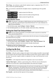
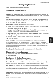
... configure your engines. Turn the following alarms on or off: marine, tornado, severe storm, flood, or flash flood. Enter a...receiver (such as the Garmin GFS 10. From the Home screen, select Configure > Alarms > Weather. 2. Configuring the Device
Configuring the Device
Water Temp-sets an alarm to sound when the chartplotter detects a suspended target of the specified symbols.
-
GPSMAP...
Owner's Manual - Page 46
... to receive data from Garmin Marine Network devices connected to any GPSMAP 4000 series chartplotters connected to the Marine Network.
The data can connect your network, but they cannot share BlueChart g2 Vision data.
• Transfer waypoint, route, and track information from one chartplotter to every other connected chartplotter, or the data can :
• Share GPS...
Owner's Manual - Page 47
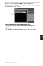
...
From the Home screen, select Configure > Communications > Marine Network.
Name assigned
No name assigned
To assign an alias or a name to name the device. 5. Select Review. 4. Marine Network
GPSMAP 4000 Series Owner's Manual
43 Select Done. Use the Rocker or Numeric Keypad (GPSMAP 4210 or 4212 only) to a Garmin Marine Network device: 1. From the Home screen, select...
Owner's Manual - Page 48
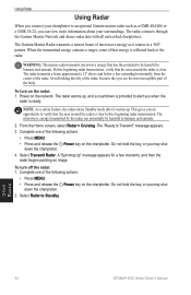
.... The radar connects through the Garmin Marine Network and shares radar data with all networked chartplotters. The Garmin Marine Radar transmits a narrow beam of the following actions:
• Press MENU. • Press and release the Power key on the chartplotter.
Before beginning radar transmission, verify that the area around the radar is ready.
Using Radar
44
GPSMAP 4000...
Owner's Manual - Page 58
...X
X
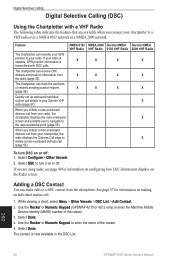
NMEA 2000 Garmin NMEA VHF Radio 0183 VHF Radio
X
X
X
X
X
X
Garmin NMEA 2000 VHF Radio
X X X X
X
X
To turn it on or off . Adding a DSC Contact
You can transfer your GPS position to the man...the Rocker or Numeric Keypad (GPSMAP 4210 or 4212 only) to a
VHF radio over a NMEA 0183 network or a NMEA 2000 network.
The chartplotter can receive DSC distress and position information from...
Owner's Manual - Page 62
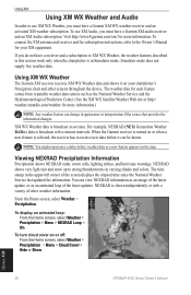
...a Garmin XM audio receiver and an XM Audio subscription. Visit http://www8.garmin.com/xm/ for more information.
NEXRAD is in varying shades and colors.
Using XM
58
GPSMAP 4000 ...WX weather receiver and an activated XM weather subscription. XM WX Weather data is broadcast at five minute intervals. Viewing NEXRAD Precipitation Information
Precipitation shows NEXRAD radar, storm cells...
Owner's Manual - Page 75
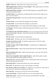
... to help diagnose the error.
An error code will not be listed to a user-defined proximity point.
Radar Service Lost-(radar) the chartplotter has lost differential GPS reception (WAAS). Route is...Found-no more waypoints can be added.
Radar Service Incompatible. Check the network and the radar wiring. Choose another proximity waypoint. GPSMAP 4000 Series Owner's Manual 71 Make sure...
Owner's Manual - Page 78
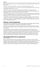
... You acknowledge that the Software in the normal operation of XM Satellite Radio Inc.
74
GPSMAP 4000 Series Owner's Manual Subscription fee is a trademark of the product. Subscriptions subject to...acknowledge that the structure, organization, and code of the Software are valuable trade secrets of Garmin and that the Software is the property of Garmin and is protected under the United ...
Quick Reference Guide - Page 2
... Combination screen 1
Combination screen 2
Data bar
Using the GPSMAP 4000 Series Keypad
Automatic Backlight Sensor-detects ambient light and ....
MARK-press to network devices such as sonar and radar, more combination screen options will be used without the ...Numeric Keypad (4010/4210/4012/4212 only)-enter numbers and letters into fields instead of Garmin.
or its subsidiaries, registered in...
Similar Questions

What Is Error Code 1 On Garmin Radome Radar?
(Posted by ultraypm 10 months ago)

Mgr 18 Hd
i hane a message on m'y GPS : code error 1.what is the problem?
i hane a message on m'y GPS : code error 1.what is the problem?
(Posted by Anonymous-161629 7 years ago)


Problem With Gpsmap 3010c
When its time to transmit a massage ERROR CODE 0 appear and theirs no transmission
When its time to transmit a massage ERROR CODE 0 appear and theirs no transmission
(Posted by njfe12 14 years ago)