Installation Instructions
Page 13
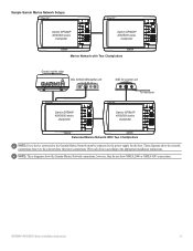
... the power supply for the boat. Sample Garmin Marine Network Setups: Garmin GPSMAP 4000/5000 series chartplotter Garmin GPSMAP 4000/5000 series chartplotter Marine Network with Two Chartplotters Garmin marine radar GDL 30/30A XM weather unit xxxx GSD 22 sounder unit xxxxxxxxxxxxxxxxxxxxxxx To transducer Garmin GPSMAP 4000/5000 series chartplotter Garmin GPSMAP 4000/5000 series chartplotter Extended Marine Network With Two Chartplotters Note: Every...
... the power supply for the boat. Sample Garmin Marine Network Setups: Garmin GPSMAP 4000/5000 series chartplotter Garmin GPSMAP 4000/5000 series chartplotter Marine Network with Two Chartplotters Garmin marine radar GDL 30/30A XM weather unit xxxx GSD 22 sounder unit xxxxxxxxxxxxxxxxxxxxxxx To transducer Garmin GPSMAP 4000/5000 series chartplotter Garmin GPSMAP 4000/5000 series chartplotter Extended Marine Network With Two Chartplotters Note: Every...
Installation Instructions
Page 14
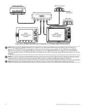
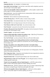
...Garmin marine radar GSD 22 sounder unit xxxx GMS 10 marine network port expander xxxxxxxxxxxxxxxxxxxxxxx To transducer GDL 30/30A XM weather receiver Garmin GPSMAP 3000 series chartplotter Garmin GPSMAP 4000/5000 series chartplotter Connecting a GPSMAP 4000/5000 Series Chartplotter to an Existing Garmin Marine Network Note: When connecting a GPSMAP 4000/5000 series chartplotter to an existing Garmin Marine... the Garmin Marine Network connections; however, it does not show NMEA 2000 or NMEA 0183 connections. 14 GPSMAP 4000/5000 Series Installation Instructions Wire the GPS antenna and...
...Garmin marine radar GSD 22 sounder unit xxxx GMS 10 marine network port expander xxxxxxxxxxxxxxxxxxxxxxx To transducer GDL 30/30A XM weather receiver Garmin GPSMAP 3000 series chartplotter Garmin GPSMAP 4000/5000 series chartplotter Connecting a GPSMAP 4000/5000 Series Chartplotter to an Existing Garmin Marine Network Note: When connecting a GPSMAP 4000/5000 series chartplotter to an existing Garmin Marine... the Garmin Marine Network connections; however, it does not show NMEA 2000 or NMEA 0183 connections. 14 GPSMAP 4000/5000 Series Installation Instructions Wire the GPS antenna and...
Technical Reference for Garmin NMEA 2000 Products
Page 4
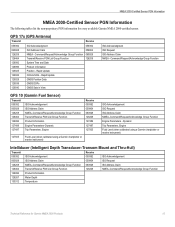
...-Certified Display Device PGN Information...13 GPSMAP 4000/5000 Series Chartplotters...13 GMI 10...14 NMEA 2000-Certified Sensor PGN Information...15 GPS 17x (GPS Antenna)...15 GFS 10 (Garmin Fuel Sensor)...15 Intelliducer (Intelligent Depth Transducer-Transom Mount and Thru-Hull)...15 GWS 10 (Garmin Wind Sensor)...16 GHP 10 (Marine Autopilot System)...16 CCU...16...
...-Certified Display Device PGN Information...13 GPSMAP 4000/5000 Series Chartplotters...13 GMI 10...14 NMEA 2000-Certified Sensor PGN Information...15 GPS 17x (GPS Antenna)...15 GFS 10 (Garmin Fuel Sensor)...15 Intelliducer (Intelligent Depth Transducer-Transom Mount and Thru-Hull)...15 GWS 10 (Garmin Wind Sensor)...16 GHP 10 (Marine Autopilot System)...16 CCU...16...
Technical Reference for Garmin NMEA 2000 Products
Page 7
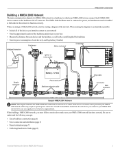
... be installed at both ends for each device (Load Equivalency Number) Fuel sensor Marine instrument Chartplotter Intelligent transducer Ignition or in-line switch Fuse Female terminator + - When building a NMEA ...2000 network, you intend to connect to understand the following concepts: • Linear backbone construction (page 4) • Power connection and distribution (page 5) • Proper termination (page 7) • Cable length and device limits (page 8) Technical Reference for Garmin...
... be installed at both ends for each device (Load Equivalency Number) Fuel sensor Marine instrument Chartplotter Intelligent transducer Ignition or in-line switch Fuse Female terminator + - When building a NMEA ...2000 network, you intend to connect to understand the following concepts: • Linear backbone construction (page 4) • Power connection and distribution (page 5) • Proper termination (page 7) • Cable length and device limits (page 8) Technical Reference for Garmin...

Technical Reference for Garmin NMEA 2000 Products
Page 16
..., 130310 - COG/SOG, 129029 - GNSS Position None None Typical Sender Depth Transducer Water Temperature Sensor Water Speed Sensor GPS Antenna, Water Speed Sensor, and Heading Sensor GPS Antenna, Water Speed Sensor, and Heading Sensor GPS Antenna GPS Antenna None None 12 Technical Reference for Garmin NMEA 2000 Products Water Speed, and 127250 - Water Speed 129026 - GNSS...
..., 130310 - COG/SOG, 129029 - GNSS Position None None Typical Sender Depth Transducer Water Temperature Sensor Water Speed Sensor GPS Antenna, Water Speed Sensor, and Heading Sensor GPS Antenna, Water Speed Sensor, and Heading Sensor GPS Antenna GPS Antenna None None 12 Technical Reference for Garmin NMEA 2000 Products Water Speed, and 127250 - Water Speed 129026 - GNSS...
Technical Reference for Garmin NMEA 2000 Products
Page 19
...127497 Trip Parameters, Engine Receive 059392 059904 060928 126208 127489 127497 127505 127505 Fluid Level (when calibrated using a Garmin chartplotter or marine instrument) Intelliducer (Intelligent Depth Transducer-Transom Mount and Thru-Hull) Transmit Receive 059392 ISO Acknowledgement 059392 ... Transmit/Receive PGN List Group Function 126208 NMEA-Command/Request/Acknowledge Group Function 126996 Product Information 128267 Water Depth 130312 Temperature Technical Reference for every available Garmin NMEA 2000-certified sensor. GPS 17x (GPS Antenna) Transmit Receive 059392...
...127497 Trip Parameters, Engine Receive 059392 059904 060928 126208 127489 127497 127505 127505 Fluid Level (when calibrated using a Garmin chartplotter or marine instrument) Intelliducer (Intelligent Depth Transducer-Transom Mount and Thru-Hull) Transmit Receive 059392 ISO Acknowledgement 059392 ... Transmit/Receive PGN List Group Function 126208 NMEA-Command/Request/Acknowledge Group Function 126996 Product Information 128267 Water Depth 130312 Temperature Technical Reference for every available Garmin NMEA 2000-certified sensor. GPS 17x (GPS Antenna) Transmit Receive 059392...
Technical Reference for Garmin NMEA 2000 Products
Page 25
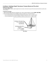
... viewing the NMEA 2000 device configuration menu, select a specific Intelliducer and select Config > Keel Offset. 2. Keel Offset Technical Reference for Garmin NMEA 2000 Products 21 Enter the measured distance from the Intelliducer location to the water line or to the keel of the boat. ...point of the boat (keel) rather than the actual location of the keel. NMEA 2000-Certified Sensor Configuration Information Intelliducer (Intelligent Depth Transducer-Transom Mount and Thru-Hull) Setting the Keel Offset Adjust the Keel Offset to the water line (Intelliducer installed on the keel), enter...
... viewing the NMEA 2000 device configuration menu, select a specific Intelliducer and select Config > Keel Offset. 2. Keel Offset Technical Reference for Garmin NMEA 2000 Products 21 Enter the measured distance from the Intelliducer location to the water line or to the keel of the boat. ...point of the boat (keel) rather than the actual location of the keel. NMEA 2000-Certified Sensor Configuration Information Intelliducer (Intelligent Depth Transducer-Transom Mount and Thru-Hull) Setting the Keel Offset Adjust the Keel Offset to the water line (Intelliducer installed on the keel), enter...

Owner's Manual
Page 21
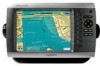
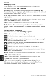
...targets and green indicates the smallest. Data Bars-shows or hides cruising, navigation, fishing, fuel, or sailing numbers (page 10). Mariner's Eye 3D, Hazard Colors Off Mariner's Eye 3D, Hazard Colors On For settings and options related to Range Rings, Safe Depth, and Lane Width, see page 13...additional settings or options for the best combination of sonar and mapping. Sonar Data-shows the sonar readings received by your transducer for the Fish Eye 3D screen, press MENU. GPSMAP 4000 Series Owner's Manual 17 Tracks-turns the track log on or off. Using Fish Eye 3D Using...
...targets and green indicates the smallest. Data Bars-shows or hides cruising, navigation, fishing, fuel, or sailing numbers (page 10). Mariner's Eye 3D, Hazard Colors Off Mariner's Eye 3D, Hazard Colors On For settings and options related to Range Rings, Safe Depth, and Lane Width, see page 13...additional settings or options for the best combination of sonar and mapping. Sonar Data-shows the sonar readings received by your transducer for the Fish Eye 3D screen, press MENU. GPSMAP 4000 Series Owner's Manual 17 Tracks-turns the track log on or off. Using Fish Eye 3D Using...
Owner's Manual
Page 42
... Numeric Keypad (GPSMAP 4210 or 4212...you have an optional sonar module and a transducer connected using NMEA 0183 or using the system (GPS) clock. Select an alarm. 4. Setting Navigation...the time or distance. Configuring the Device 38 GPSMAP 4000 Series Owner's Manual By default, all alarms are ... Use the Rocker or Numeric Keypad (GPSMAP 4210 or 4212 only) to sound when the GPS location accuracy falls outside the userdetermined value.... distance. GPS Accuracy-sets an alarm to specify alarm information. Clock-sets an alarm using the Garmin Marine Network to...
... Numeric Keypad (GPSMAP 4210 or 4212...you have an optional sonar module and a transducer connected using NMEA 0183 or using the system (GPS) clock. Select an alarm. 4. Setting Navigation...the time or distance. Configuring the Device 38 GPSMAP 4000 Series Owner's Manual By default, all alarms are ... Use the Rocker or Numeric Keypad (GPSMAP 4210 or 4212 only) to sound when the GPS location accuracy falls outside the userdetermined value.... distance. GPS Accuracy-sets an alarm to specify alarm information. Clock-sets an alarm using the Garmin Marine Network to...
Owner's Manual
Page 43
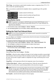
...transducer location. Follow the onscreen directions for more information. 1. If you do not have a subscription to XM WX Weather and a Garmin XM WX Weather receiver (such as the Garmin...to an external fuel sensor, such as a GDL 30A) connected using the Garmin Marine Network to sound when the chartplotter detects a suspended target of from the bottom...receive fuel-level information, your chartplotter to offset for large fish only. You can configure your chartplotter must have a speed-sensing transducer, this menu does not appear. Temp Offset-set the fuel alarm level: 1. GPSMAP...
...transducer location. Follow the onscreen directions for more information. 1. If you do not have a subscription to XM WX Weather and a Garmin XM WX Weather receiver (such as the Garmin...to an external fuel sensor, such as a GDL 30A) connected using the Garmin Marine Network to sound when the chartplotter detects a suspended target of from the bottom...receive fuel-level information, your chartplotter to offset for large fish only. You can configure your chartplotter must have a speed-sensing transducer, this menu does not appear. Temp Offset-set the fuel alarm level: 1. GPSMAP...

Owner's Manual
Page 44
...the depth at the bottom of the keel. • If you are measuring down to the water line (transducer installed on the bottom of the boat. • If you to 24 minutes). • Configuring the Device 40 GPSMAP 4000 Series Owner's Manual AIS alerts you are measuring up to the keel... (transducer installed at the surface. to 2.0 mi.). • Select Time To (Safe Zone) to sound an alarm if Automatic ...
...the depth at the bottom of the keel. • If you are measuring down to the water line (transducer installed on the bottom of the boat. • If you to 24 minutes). • Configuring the Device 40 GPSMAP 4000 Series Owner's Manual AIS alerts you are measuring up to the keel... (transducer installed at the surface. to 2.0 mi.). • Select Time To (Safe Zone) to sound an alarm if Automatic ...
Owner's Manual
Page 46
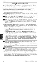
...WX weather and XM Radio data when connected to the Garmin Marine Network. Previous Garmin Marine Network-compatible chartplotter models (such as the GPSMAP 3010) can be connected to your GPSMAP 4000 series chartplotter to a Garmin Marine Network to receive data from and to share data with any NMEA ... Garmin Marine Network and an appropriate transducer. NOTE: BlueChart g2 Vision cartography is shared by any chartplotter in the Marine Network or to a GMS 10 Marine Network Port Expander, with every other connected chartplotter, or the data can : • Share GPS data from a GPS 17 or GPS ...
...WX weather and XM Radio data when connected to the Garmin Marine Network. Previous Garmin Marine Network-compatible chartplotter models (such as the GPSMAP 3010) can be connected to your GPSMAP 4000 series chartplotter to a Garmin Marine Network to receive data from and to share data with any NMEA ... Garmin Marine Network and an appropriate transducer. NOTE: BlueChart g2 Vision cartography is shared by any chartplotter in the Marine Network or to a GMS 10 Marine Network Port Expander, with every other connected chartplotter, or the data can : • Share GPS data from a GPS 17 or GPS ...
Owner's Manual
Page 54
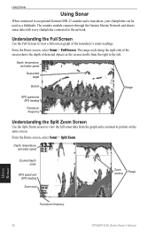
... water speed Zoomed depth scale GPS speed and GPS heading Zoom level Zoom window Range Transducer frequency Using Sonar 50 GPSMAP 4000 Series Owner's Manual The range scale along the right side of the screen shows the depth of the transducer's sonar readings. The sounder module connects through the Garmin Marine Network and shares sonar data with...
... water speed Zoomed depth scale GPS speed and GPS heading Zoom level Zoom window Range Transducer frequency Using Sonar 50 GPSMAP 4000 Series Owner's Manual The range scale along the right side of the screen shows the depth of the transducer's sonar readings. The sounder module connects through the Garmin Marine Network and shares sonar data with...
Owner's Manual
Page 55
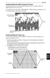
Depth, temperature, and water speed GPS speed and GPS heading Range Transducer frequencies Understanding the Temp Log If you are .... Temperature and depth Time elapsed Temperature range Using Sonar GPSMAP 4000 Series Owner's Manual 51 The current temperature and depth are using a temperature-capable transducer, the Temp Log screen keeps a graphic log of ... • Select Scale to the left as information is received. 2. Using Sonar Understanding the Split Frequency Screen Use the Split Frequency screen (dual frequency transducer only) to view both the 50kHz and 200kHz frequencies on...
Depth, temperature, and water speed GPS speed and GPS heading Range Transducer frequencies Understanding the Temp Log If you are .... Temperature and depth Time elapsed Temperature range Using Sonar GPSMAP 4000 Series Owner's Manual 51 The current temperature and depth are using a temperature-capable transducer, the Temp Log screen keeps a graphic log of ... • Select Scale to the left as information is received. 2. Using Sonar Understanding the Split Frequency Screen Use the Split Frequency screen (dual frequency transducer only) to view both the 50kHz and 200kHz frequencies on...
Owner's Manual
Page 56
...or hides water temperature, battery voltage, water speed (if your boat. The target depth of the reference line. Using Sonar 52 GPSMAP 4000 Series Owner's Manual A-Scope-creates a vertical flasher along the right side of the water. Suspended targets appear as symbols. Background... Hide). The chartplotter does not interpret the sonar return data (default). Color Scheme-choose white (black, if using a speed-capable transducer, select Auto to have the scroll speed automatically adjust to help reduce clutter. Using Sonar Setting Up Sonar Use the Sonar Setup screen...
...or hides water temperature, battery voltage, water speed (if your boat. The target depth of the reference line. Using Sonar 52 GPSMAP 4000 Series Owner's Manual A-Scope-creates a vertical flasher along the right side of the water. Suspended targets appear as symbols. Background... Hide). The chartplotter does not interpret the sonar return data (default). Color Scheme-choose white (black, if using a speed-capable transducer, select Auto to have the scroll speed automatically adjust to help reduce clutter. Using Sonar Setting Up Sonar Use the Sonar Setup screen...
Owner's Manual
Page 57
...of the depth scale on screen (200kHz, 50kHz, or Dual) when using a dual-frequency transducer. Pause Sonar-select to the bottom. The zoom is cluttered, decrease the gain. Gain-control the sensitivity of the sonar receiver (Auto or, to set the depth range of the Full screen. Select Up, Down, ...or Auto to adjust manually, Up or Down). Range-adjust the range of the magnified area. • 4x Zoom-four times the magnification. GPSMAP 4000 Series Owner's Manual 53 ...
...of the depth scale on screen (200kHz, 50kHz, or Dual) when using a dual-frequency transducer. Pause Sonar-select to the bottom. The zoom is cluttered, decrease the gain. Gain-control the sensitivity of the sonar receiver (Auto or, to set the depth range of the Full screen. Select Up, Down, ...or Auto to adjust manually, Up or Down). Range-adjust the range of the magnified area. • 4x Zoom-four times the magnification. GPSMAP 4000 Series Owner's Manual 53 ...
Owner's Manual
Page 74
... 70 GPSMAP 4000 Series Owner's Manual Entering Target Water Temperature-(temperature sensor/transducer) the water temperature is attached that requires a software update. Check the network and the antenna wiring. Enter a number between (0 - 15)-invalid NMEA 2000 System instance. Marine Weather Warning...invalid DSC MMSI was entered. GPS Service Lost-the chartplotter has lost communications with the remote GPS unit. Default value selected.-an invalid entry was entered. DSC Position Report Received From -a position report has been received by the DSC module. ...
... 70 GPSMAP 4000 Series Owner's Manual Entering Target Water Temperature-(temperature sensor/transducer) the water temperature is attached that requires a software update. Check the network and the antenna wiring. Enter a number between (0 - 15)-invalid NMEA 2000 System instance. Marine Weather Warning...invalid DSC MMSI was entered. GPS Service Lost-the chartplotter has lost communications with the remote GPS unit. Default value selected.-an invalid entry was entered. DSC Position Report Received From -a position report has been received by the DSC module. ...
Owner's Manual
Page 75
...-(sonar) the boat has entered the user-defined shallow water depth. NMEA Depth Is Below Transducer-(sonar) the NMEA depth input is full. Make sure you have a clear view of the... found while attempting a user data transfer. Radar Service Lost-(radar) the chartplotter has lost differential GPS reception (WAAS). Check the network and the radar wiring. Severe Storm Warning-(XM WX weather)... waypoints can support. Radar Guard Zone Alarm-(radar) an object has been detected in effect. GPSMAP 4000 Series Owner's Manual 71 Appendix MARPA: Target Lost-(radar) unable to a user-defined ...
...-(sonar) the boat has entered the user-defined shallow water depth. NMEA Depth Is Below Transducer-(sonar) the NMEA depth input is full. Make sure you have a clear view of the... found while attempting a user data transfer. Radar Service Lost-(radar) the chartplotter has lost differential GPS reception (WAAS). Check the network and the radar wiring. Severe Storm Warning-(XM WX weather)... waypoints can support. Radar Guard Zone Alarm-(radar) an object has been detected in effect. GPSMAP 4000 Series Owner's Manual 71 Appendix MARPA: Target Lost-(radar) unable to a user-defined ...
Owner's Manual
Page 76
...off. Unknown bridge height within automatic guidance route. Make sure an SD card is not working properly. Water Temperature Alarm-(temperature sensor/transducer) the water temperature has entered or left the user-defined water temperature alarm zone. Choose another name. Check the network and the ... route, but the end point has been moved to be sent in effect. Check the wheel for assistance updating your network. 72 GPSMAP 4000 Series Owner's Manual Waypoint Memory is Full, Can't Create Waypoint-the User Waypoint memory is needed . Erase existing waypoints to ...
...off. Unknown bridge height within automatic guidance route. Make sure an SD card is not working properly. Water Temperature Alarm-(temperature sensor/transducer) the water temperature has entered or left the user-defined water temperature alarm zone. Choose another name. Check the network and the ... route, but the end point has been moved to be sent in effect. Check the wheel for assistance updating your network. 72 GPSMAP 4000 Series Owner's Manual Waypoint Memory is Full, Can't Create Waypoint-the User Waypoint memory is needed . Erase existing waypoints to ...
Owner's Manual
Page 80
...a destination by name 24 service points 9 settings alarms 38 chart 9 combinations 22 communications 37 fish eye 3D 17 initializing 2 mariner's eye 3D 16 navigation chart 7 sonar 52 sonar (advanced) 52 76 system 35 XM audio 65 simulator mode 4 soft ... temp log 51 tides/currents 9 tide station 9, 29 time 37 time zone 37 tracks 13, 17 deleting all 32 transducer configuring 39 transfer data 31 transmit radar 44 tropical depression 59 tropical storm 59 true north 36 turn the unit off ... 23 whiteline 52 wireless devices 37 X XM 58 audio 41, 65 weather 58 Z zoom 6, 53 GPSMAP 4000 Series Owner's Manual
...a destination by name 24 service points 9 settings alarms 38 chart 9 combinations 22 communications 37 fish eye 3D 17 initializing 2 mariner's eye 3D 16 navigation chart 7 sonar 52 sonar (advanced) 52 76 system 35 XM audio 65 simulator mode 4 soft ... temp log 51 tides/currents 9 tide station 9, 29 time 37 time zone 37 tracks 13, 17 deleting all 32 transducer configuring 39 transfer data 31 transmit radar 44 tropical depression 59 tropical storm 59 true north 36 turn the unit off ... 23 whiteline 52 wireless devices 37 X XM 58 audio 41, 65 weather 58 Z zoom 6, 53 GPSMAP 4000 Series Owner's Manual

