Installation Instructions
Page 12
... or GMR 404/406), or an XM Weather receiver (GDL30/30A). The Garmin Marine Network Cable: • The Garmin Marine Network Cable has a locking ring that can connect a GPSMAP 4000/5000 chartplotter to a Marine Network with a GPSMAP 3000 series chartplotter: • They will share GPS 17 GPS position information as well as a Garmin GMR radar, GSD sounder, or GDL XM Weather...
... or GMR 404/406), or an XM Weather receiver (GDL30/30A). The Garmin Marine Network Cable: • The Garmin Marine Network Cable has a locking ring that can connect a GPSMAP 4000/5000 chartplotter to a Marine Network with a GPSMAP 3000 series chartplotter: • They will share GPS 17 GPS position information as well as a Garmin GMR radar, GSD sounder, or GDL XM Weather...
Installation Instructions
Page 14
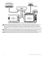
.... Note: This diagram shows the Garmin Marine Network connections; Garmin marine radar GSD 22 sounder unit xxxx GMS 10 marine network port expander xxxxxxxxxxxxxxxxxxxxxxx To transducer GDL 30/30A XM weather receiver Garmin GPSMAP 3000 series chartplotter Garmin GPSMAP 4000/5000 series chartplotter Connecting a GPSMAP 4000/5000 Series Chartplotter to an Existing Garmin Marine Network Note: When connecting a GPSMAP 4000/5000 series chartplotter to...
.... Note: This diagram shows the Garmin Marine Network connections; Garmin marine radar GSD 22 sounder unit xxxx GMS 10 marine network port expander xxxxxxxxxxxxxxxxxxxxxxx To transducer GDL 30/30A XM weather receiver Garmin GPSMAP 3000 series chartplotter Garmin GPSMAP 4000/5000 series chartplotter Connecting a GPSMAP 4000/5000 Series Chartplotter to an Existing Garmin Marine Network Note: When connecting a GPSMAP 4000/5000 series chartplotter to...
Installation Instructions
Page 16
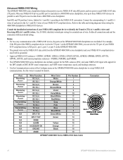
...Receiving Port 1 Receiving Port 2 Receiving Port 3 Receiving Port 4 Transmitting Port 1 Transmitting Port 2 N/A N/A N/A N/A N/A N/A N/a Wire Function RX / A (+) RX / B (-) RX / A (+) RX / B (-) RX / A (+) RX / B (-) RX / A (+) rX / B (-) tX / A (+) tX / B (-) tX / A (+) tX / B (-) GPS 17 in parallel to each port to the A (+) and B (-) wires of the Configure menu on the GPSMAP...GPGSV, GPGLL, GPBOD, GPRMB, GPRTE, GPVTG, GPWPL, GPXTE, and Garmin proprietary sentences-PGRME, PGRMM, and PGRMZ. • The GPSMAP 4000/5000 series chartplotter also includes support for the WPL sentence, DSC, ...
...Receiving Port 1 Receiving Port 2 Receiving Port 3 Receiving Port 4 Transmitting Port 1 Transmitting Port 2 N/A N/A N/A N/A N/A N/A N/a Wire Function RX / A (+) RX / B (-) RX / A (+) RX / B (-) RX / A (+) RX / B (-) RX / A (+) rX / B (-) tX / A (+) tX / B (-) tX / A (+) tX / B (-) GPS 17 in parallel to each port to the A (+) and B (-) wires of the Configure menu on the GPSMAP...GPGSV, GPGLL, GPBOD, GPRMB, GPRTE, GPVTG, GPWPL, GPXTE, and Garmin proprietary sentences-PGRME, PGRMM, and PGRMZ. • The GPSMAP 4000/5000 series chartplotter also includes support for the WPL sentence, DSC, ...
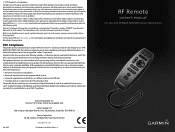
Remote Instructions (Multilingual)
Page 1
...Southampton, Hampshire, SO40 9RB UK Garmin Corporation No. 68, Jangshu 2nd Road, Shijr, Taipei County, Taiwan www.garmin.com Part Number 190-00856-10 Rev. GPSMAP® is a trademark of this device under Part 15 regulations. Visit the Garmin Web site (www.garmin.com) for current updates and...no part of this and other Garmin products. Repairs should only be determined by turning the equipment off and on a different circuit from the GPS unit. • Consult the dealer or an experienced radio/TV technician for any interference received, including interference that may not cause...
...Southampton, Hampshire, SO40 9RB UK Garmin Corporation No. 68, Jangshu 2nd Road, Shijr, Taipei County, Taiwan www.garmin.com Part Number 190-00856-10 Rev. GPSMAP® is a trademark of this device under Part 15 regulations. Visit the Garmin Web site (www.garmin.com) for current updates and...no part of this and other Garmin products. Repairs should only be determined by turning the equipment off and on a different circuit from the GPS unit. • Consult the dealer or an experienced radio/TV technician for any interference received, including interference that may not cause...
Technical Reference for Garmin NMEA 2000 Products
Page 19
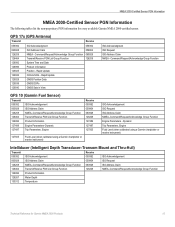
... 2000-certified sensor. Dynamic Trip Parameters, Engine Fluid Level (when calibrated using a Garmin chartplotter or marine instrument) ISO Acknowledgement ISO Request ISO Address Claim NMEA-Command/Request/Acknowledge Group Function Engine Parameters - GPS 17x (GPS Antenna) Transmit Receive 059392 060928 126208 126464 126992 126996 129025 129026 129029 129539 129540 ISO Acknowledgment ISO Address Claim NMEA...
... 2000-certified sensor. Dynamic Trip Parameters, Engine Fluid Level (when calibrated using a Garmin chartplotter or marine instrument) ISO Acknowledgement ISO Request ISO Address Claim NMEA-Command/Request/Acknowledge Group Function Engine Parameters - GPS 17x (GPS Antenna) Transmit Receive 059392 060928 126208 126464 126992 126996 129025 129026 129029 129539 129540 ISO Acknowledgment ISO Address Claim NMEA...
Technical Reference for Garmin NMEA 2000 Products
Page 23
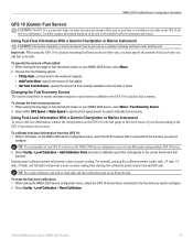
... GFS 10 device that is connected to the fuel tank you want to calculate fuel economy. Using Fuel-Level Information With a Garmin Chartplotter or Marine Instrument To receive fuel-level information, connect the wiring harness on your NMEA 2000 device, select Menu. 2. Tip: The serial number of each.... While viewing the fuel page or fuel instrument screen on your boat according to help differentiate among multiple GFS 10 devices. 2. Select either GPS Speed or Water Speed to specify which speed sensor is used on your NMEA 2000 device, select Menu > Fuel Economy Source. 2. Tip:...
... GFS 10 device that is connected to the fuel tank you want to calculate fuel economy. Using Fuel-Level Information With a Garmin Chartplotter or Marine Instrument To receive fuel-level information, connect the wiring harness on your NMEA 2000 device, select Menu. 2. Tip: The serial number of each.... While viewing the fuel page or fuel instrument screen on your boat according to help differentiate among multiple GFS 10 devices. 2. Select either GPS Speed or Water Speed to specify which speed sensor is used on your NMEA 2000 device, select Menu > Fuel Economy Source. 2. Tip:...
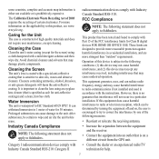
Important Safety and Product Infomation (Multilingual)
Page 3
... cleaning. However, there is sensitive to correct the interference by turning the equipment off and on a different circuit from the GPS unit. Prolonged submersion can withstand immersion in accordance with Part 15 of the FCC interference limits for the screen) using an ..., abrasives, or anti-grease detergents will not occur in a residential installation, and are designed to this device must accept any interference received, including interference that may cause harmful interference to clean the lens using a cloth dampened with a special anti-reflective coating that is...
... cleaning. However, there is sensitive to correct the interference by turning the equipment off and on a different circuit from the GPS unit. Prolonged submersion can withstand immersion in accordance with Part 15 of the FCC interference limits for the screen) using an ..., abrasives, or anti-grease detergents will not occur in a residential installation, and are designed to this device must accept any interference received, including interference that may cause harmful interference to clean the lens using a cloth dampened with a special anti-reflective coating that is...
Owner's Manual
Page 4
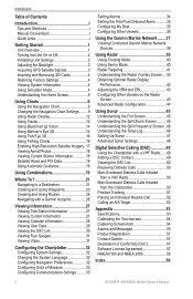
...Unit On or Off 2 Initializing Unit Settings 2 Adjusting the Backlight 3 Acquiring GPS Satellite Signals 3 Inserting and Removing SD Cards 4 Restoring Factory Settings 4 ...Tracks 12 Using BlueChart g2 Vision 14 Using Mariner's Eye 3D 14 Using Fish Eye 3D...and Using Routes 25 Navigating with a Garmin Autopilot 26 Viewing Information 27 Viewing ...Vessels 36 Using the Garmin Marine Network........37 Viewing Connected Garmin Marine Network Devices 38 Using... Contact 49 Viewing the DSC List 50 Receiving Distress Calls 50 Man-Overboard Distress Calls ...Garmin 57 Declaration of Conformity (DoC ...
...Unit On or Off 2 Initializing Unit Settings 2 Adjusting the Backlight 3 Acquiring GPS Satellite Signals 3 Inserting and Removing SD Cards 4 Restoring Factory Settings 4 ...Tracks 12 Using BlueChart g2 Vision 14 Using Mariner's Eye 3D 14 Using Fish Eye 3D...and Using Routes 25 Navigating with a Garmin Autopilot 26 Viewing Information 27 Viewing ...Vessels 36 Using the Garmin Marine Network........37 Viewing Connected Garmin Marine Network Devices 38 Using... Contact 49 Viewing the DSC List 50 Receiving Distress Calls 50 Man-Overboard Distress Calls ...Garmin 57 Declaration of Conformity (DoC ...

Owner's Manual
Page 7
... signal strength bars at www.garmin.com/aboutGPS. For more information about GPS, visit the Garmin® Web site at the top of the Home screen are green . Refer to automatically adjust the backlight based on , the GPS receiver must collect satellite data and ...establish its current location. Select Backlight. To manually adjust the backlight, either select Up or Down, use the ROCKER (GPSMAP...
... signal strength bars at www.garmin.com/aboutGPS. For more information about GPS, visit the Garmin® Web site at the top of the Home screen are green . Refer to automatically adjust the backlight based on , the GPS receiver must collect satellite data and ...establish its current location. Select Backlight. To manually adjust the backlight, either select Up or Down, use the ROCKER (GPSMAP...
Owner's Manual
Page 8
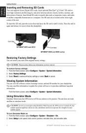
... cards to transfer data such as waypoints, routes, and tracks to cancel. Select Factory Settings. 3. Using Simulator Mode Simulator Mode turns the GPS receiver off . From the Home screen, select Configure > System > Simulator > On. 2. The SD card slot is turned off for use ...or select Back to another compatible Garmin unit or a computer. Viewing System Information You can restore your chartplotter. To turn Simulator Mode on the lower-right corner of actual satellite signals. Card label GPSMAP 4010 and 4012 Card label GPSMAP 4008 and 5000 series Restoring Factory...
... cards to transfer data such as waypoints, routes, and tracks to cancel. Select Factory Settings. 3. Using Simulator Mode Simulator Mode turns the GPS receiver off . From the Home screen, select Configure > System > Simulator > On. 2. The SD card slot is turned off for use ...or select Back to another compatible Garmin unit or a computer. Viewing System Information You can restore your chartplotter. To turn Simulator Mode on the lower-right corner of actual satellite signals. Card label GPSMAP 4010 and 4012 Card label GPSMAP 4008 and 5000 series Restoring Factory...
Owner's Manual
Page 39
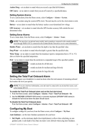
...Use the ROCKER (GPSMAP 4000 series) or onscreen keyboard (GPSMAP 5000 series) to sound when the battery reaches a user-determined low voltage. GPSMAP® 4000/5000... settings for your unit must be on for your chartplotter to receive sonar information. Battery-set an alarm to indicate the fuel level... sounder module) wired through NMEA 0183 or connected to the Garmin Marine Network to sound an alarm when the total amount of remaining... screen, select Configure > Alarms > Fuel > Total Fuel Onboard > Off. GPS Accuracy-set an alarm to sound when the unit detects a suspended target of ...
...Use the ROCKER (GPSMAP 4000 series) or onscreen keyboard (GPSMAP 5000 series) to sound when the battery reaches a user-determined low voltage. GPSMAP® 4000/5000... settings for your unit must be on for your chartplotter to receive sonar information. Battery-set an alarm to indicate the fuel level... sounder module) wired through NMEA 0183 or connected to the Garmin Marine Network to sound an alarm when the total amount of remaining... screen, select Configure > Alarms > Fuel > Total Fuel Onboard > Off. GPS Accuracy-set an alarm to sound when the unit detects a suspended target of ...

Owner's Manual
Page 50
...are using a temperature-capable transducer, the Temp Log screen keeps a graphic log of temperature readings over time. Using Sonar 46 GPSMAP® 4000/5000 Series Owner's Manual From the Home screen, select Sonar > Split Frequency. From the Home screen, select...along the bottom. A 200 kHz frequency graph appears on the right. Depth, temperature, and water speed GPS speed and GPS heading Range Transducer frequencies Understanding the Temp Log If you are shown in the upper-left corner. The ...Frequency screen (dual-frequency transducer only) to the left as information is received.
...are using a temperature-capable transducer, the Temp Log screen keeps a graphic log of temperature readings over time. Using Sonar 46 GPSMAP® 4000/5000 Series Owner's Manual From the Home screen, select Sonar > Split Frequency. From the Home screen, select...along the bottom. A 200 kHz frequency graph appears on the right. Depth, temperature, and water speed GPS speed and GPS heading Range Transducer frequencies Understanding the Temp Log If you are shown in the upper-left corner. The ...Frequency screen (dual-frequency transducer only) to the left as information is received.
Owner's Manual
Page 53
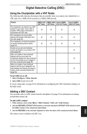
... the Chartplotter with DSC calls. Adding a DSC Contact You can transfer your GPS position to your Garmin VHF radio (page 50). Feature The chartplotter can make calls to a VHF...page 43 for information on or off : 1. Select Configure > Other Vessels. 2. The chartplotter can receive DSC distress and position information from your radio. While viewing a chart, select Menu > Other Vessels >...If you are available when you to navigate to turn DSC on the radar screen. DSC GPSMAP® 4000/5000 Series Owner's Manual 49 If your chartplotter to a DSC contact from...
... the Chartplotter with DSC calls. Adding a DSC Contact You can transfer your GPS position to your Garmin VHF radio (page 50). Feature The chartplotter can make calls to a VHF...page 43 for information on or off : 1. Select Configure > Other Vessels. 2. The chartplotter can receive DSC distress and position information from your radio. While viewing a chart, select Menu > Other Vessels >...If you are available when you to navigate to turn DSC on the radar screen. DSC GPSMAP® 4000/5000 Series Owner's Manual 49 If your chartplotter to a DSC contact from...
Owner's Manual
Page 57
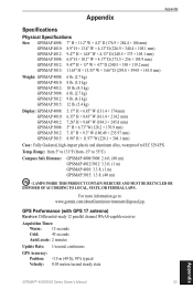
...°C) Compass Safe Distance GPSMAP 4008/5008: 2.6 ft. (80 cm) GPSMAP 4012/5012: 3.3 ft. (1 m) GPSMAP 4010: 3.3 ft. (1 m) GPSMAP 5015: 1.3 ft. (40 cm) Hg - Range: from 5° to 131°F (from -15° to local, state, or federal laws. For more information go to IEC 529-IPX Temp. GPS Performance (with GPS 17 antenna) Receiver: Differential-ready 12 parallel....49 × 235.97 mm) 8.98" H × 11.97" W (228.1 × 304.1 mm) Case: Fully Gasketed, high-impact plastic and aluminum alloy, waterproof to : www.garmin.com/aboutGarmin/environment/disposal.jsp.
...°C) Compass Safe Distance GPSMAP 4008/5008: 2.6 ft. (80 cm) GPSMAP 4012/5012: 3.3 ft. (1 m) GPSMAP 4010: 3.3 ft. (1 m) GPSMAP 5015: 1.3 ft. (40 cm) Hg - Range: from 5° to 131°F (from -15° to local, state, or federal laws. For more information go to IEC 529-IPX Temp. GPS Performance (with GPS 17 antenna) Receiver: Differential-ready 12 parallel....49 × 235.97 mm) 8.98" H × 11.97" W (228.1 × 304.1 mm) Case: Fully Gasketed, high-impact plastic and aluminum alloy, waterproof to : www.garmin.com/aboutGarmin/environment/disposal.jsp.
Owner's Manual
Page 59
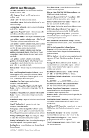
...Moving Fast Enough to the GPS 17 antenna. Contact product support. Contact Garmin Product Support. Distress Call Received From -A distress call has been received by the DSC module. DSC Position Report Received From -a position report has been received by the DSC module. GPS Service Lost-the unit has...speed wheel for deep water. If wheel is a specified alarm distance from the destination waypoint. Database Error-general database error. GPSMAP® 4000/5000 Series Owner's Manual Appendix Deep Water Alarm-(sonar) the boat has entered userdefined value for blockage and calibrate...
...Moving Fast Enough to the GPS 17 antenna. Contact product support. Contact Garmin Product Support. Distress Call Received From -A distress call has been received by the DSC module. DSC Position Report Received From -a position report has been received by the DSC module. GPS Service Lost-the unit has...speed wheel for deep water. If wheel is a specified alarm distance from the destination waypoint. Database Error-general database error. GPSMAP® 4000/5000 Series Owner's Manual Appendix Deep Water Alarm-(sonar) the boat has entered userdefined value for blockage and calibrate...
Owner's Manual
Page 62
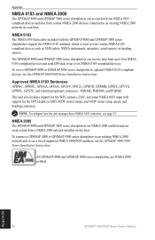
... see page 33. Appendix 58 GPSMAP® 4000/5000 Series Owner's Manual The GPSMAP 4000 and GPSMAP 5000 series chartplotters can receive data from up to four NMEA 0183-compliant devices and send GPS data to up to an existing... unit also includes support for the WPL sentence, DSC, and sonar NMEA 0183 input with the GPSMAP 4000 and GPSMAP 5000 series chartplotters support the NMEA 0183 standard, which is used to wire various NMEA 0183compliant devices..., GPRMC, GPGGA, GPGSA, GPGSV, GPGLL, GPBOD, GPRMB, GPRTE, GPVTG, GPWPL, GPXTE, and Garmin proprietary sentences-PGRME, PGRMM, and PGRMZ.
... see page 33. Appendix 58 GPSMAP® 4000/5000 Series Owner's Manual The GPSMAP 4000 and GPSMAP 5000 series chartplotters can receive data from up to four NMEA 0183-compliant devices and send GPS data to up to an existing... unit also includes support for the WPL sentence, DSC, and sonar NMEA 0183 input with the GPSMAP 4000 and GPSMAP 5000 series chartplotters support the NMEA 0183 standard, which is used to wire various NMEA 0183compliant devices..., GPRMC, GPGGA, GPGSA, GPGSV, GPGLL, GPBOD, GPRMB, GPRTE, GPVTG, GPWPL, GPXTE, and Garmin proprietary sentences-PGRME, PGRMM, and PGRMZ.


