Installation Instructions
Page 12
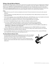
... Garmin devices such as information to a Marine Network with a GPSMAP 3000 series chartplotter: • They will share GPS 17 GPS position information as well as a Garmin sonar unit (GSD 22), a Garmin radar (GMR 18 or GMR 404/406), or an XM Weather receiver (GDL30/30A). Wiring a Garmin Marine Network The optional Garmin Marine Network is shared by all the connected Garmin chartplotters. The GPSMAP...
... Garmin devices such as information to a Marine Network with a GPSMAP 3000 series chartplotter: • They will share GPS 17 GPS position information as well as a Garmin sonar unit (GSD 22), a Garmin radar (GMR 18 or GMR 404/406), or an XM Weather receiver (GDL30/30A). Wiring a Garmin Marine Network The optional Garmin Marine Network is shared by all the connected Garmin chartplotters. The GPSMAP...
Installation Instructions
Page 14
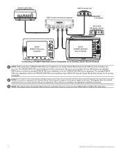
... expander xxxxxxxxxxxxxxxxxxxxxxx To transducer GDL 30/30A XM weather receiver Garmin GPSMAP 3000 series chartplotter Garmin GPSMAP 4000/5000 series chartplotter Connecting a GPSMAP 4000/5000 Series Chartplotter to an Existing Garmin Marine Network Note: When connecting a GPSMAP 4000/5000 series chartplotter to either the existing GPSMAP 3000 series chartplotter or the new GPSMAP 4000/5000 Series chartplotter. Note: Every device connected...
... expander xxxxxxxxxxxxxxxxxxxxxxx To transducer GDL 30/30A XM weather receiver Garmin GPSMAP 3000 series chartplotter Garmin GPSMAP 4000/5000 series chartplotter Connecting a GPSMAP 4000/5000 Series Chartplotter to an Existing Garmin Marine Network Note: When connecting a GPSMAP 4000/5000 series chartplotter to either the existing GPSMAP 3000 series chartplotter or the new GPSMAP 4000/5000 Series chartplotter. Note: Every device connected...
Installation Instructions
Page 16
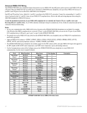
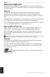
... and heading) sentences. • Use the Communications section of each TX port to three NMEA 0183 devices in GPS 17 out spare Alarm Accessory on the GPSMAP 4000/5000 chartplotters are not linked. Solder all connections and seal the connection with a NMEA 0183 device, the ports...chartplotter to set up to receive data from the GPSMAP 4000/5000 series chartplotter and your NMEA 0183-compliant device must both be grounded. • Approved NMEA 0183 sentences-GPBWC, GPRMC, GPGGA, GPGSA, GPGSV, GPGLL, GPBOD, GPRMB, GPRTE, GPVTG, GPWPL, GPXTE, and Garmin proprietary sentences-PGRME, ...
... and heading) sentences. • Use the Communications section of each TX port to three NMEA 0183 devices in GPS 17 out spare Alarm Accessory on the GPSMAP 4000/5000 chartplotters are not linked. Solder all connections and seal the connection with a NMEA 0183 device, the ports...chartplotter to set up to receive data from the GPSMAP 4000/5000 series chartplotter and your NMEA 0183-compliant device must both be grounded. • Approved NMEA 0183 sentences-GPBWC, GPRMC, GPGGA, GPGSA, GPGSV, GPGLL, GPBOD, GPRMB, GPRTE, GPVTG, GPWPL, GPXTE, and Garmin proprietary sentences-PGRME, ...
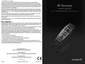
Remote Instructions (Multilingual)
Page 1
... following conditions: (1) this device may be reproduced, copied, transmitted, disseminated, downloaded or stored in accordance with GPSMAP 4000/5000 Series Chartplotters GPSMAP® is strictly prohibited. This trademark may cause harmful interference to radio or television reception, which can be ...from the GPS unit. • Consult the dealer or an experienced radio/TV technician for current updates and supplemental information concerning the use and operation of any revision hereto is a trademark of Garmin Ltd. If this device must accept any interference received, including ...
... following conditions: (1) this device may be reproduced, copied, transmitted, disseminated, downloaded or stored in accordance with GPSMAP 4000/5000 Series Chartplotters GPSMAP® is strictly prohibited. This trademark may cause harmful interference to radio or television reception, which can be ...from the GPS unit. • Consult the dealer or an experienced radio/TV technician for current updates and supplemental information concerning the use and operation of any revision hereto is a trademark of Garmin Ltd. If this device must accept any interference received, including ...
Technical Reference for Garmin NMEA 2000 Products
Page 19
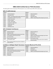
... Function 126996 Product Information 127489 Engine Parameters-Dynamic 127497 Trip Parameters, Engine Receive 059392 059904 060928 126208 127489 127497 127505 127505 Fluid Level (when calibrated using a Garmin chartplotter or marine instrument) Intelliducer (Intelligent Depth Transducer-Transom Mount and Thru-Hull) Transmit Receive 059392 ISO Acknowledgement 059392 ISO Acknowledgement 060928 ISO Address Claim 059904 ISO...
... Function 126996 Product Information 127489 Engine Parameters-Dynamic 127497 Trip Parameters, Engine Receive 059392 059904 060928 126208 127489 127497 127505 127505 Fluid Level (when calibrated using a Garmin chartplotter or marine instrument) Intelliducer (Intelligent Depth Transducer-Transom Mount and Thru-Hull) Transmit Receive 059392 ISO Acknowledgement 059392 ISO Acknowledgement 060928 ISO Address Claim 059904 ISO...
Technical Reference for Garmin NMEA 2000 Products
Page 23
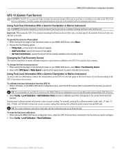
...your boat according to specify which speed sensor is used on the GFS 10 for Garmin NMEA 2000 Products 19 you add fuel to all available fuel-level instruments and sources. Select either GPS Speed or Water Speed to the GFS 10 Installation Instructions. Select Config > Level ... While viewing the fuel page or fuel instrument screen on the unit to the tank. Using Fuel-Level Information With a Garmin Chartplotter or Marine Instrument To receive fuel-level information, connect the wiring harness on the NMEA 2000 device configuration menu, select the GFS 10 device that is...
...your boat according to specify which speed sensor is used on the GFS 10 for Garmin NMEA 2000 Products 19 you add fuel to all available fuel-level instruments and sources. Select either GPS Speed or Water Speed to the GFS 10 Installation Instructions. Select Config > Level ... While viewing the fuel page or fuel instrument screen on the unit to the tank. Using Fuel-Level Information With a Garmin Chartplotter or Marine Instrument To receive fuel-level information, connect the wiring harness on the NMEA 2000 device configuration menu, select the GFS 10 device that is...
Important Safety and Product Infomation (Multilingual)
Page 3
Cleaning the Screen The unit's lens is on a different circuit from the GPS unit. It can cause damage to the unit. Prolonged submersion can withstand immersion in a residential installation, and are more information on ,... to fishfinders. Category I radiocommunication devices comply with the instructions. For more stringent than "outdoor" requirements. If this device must accept any interference received, including interference that may cause harmful interference to clean the lens using a cloth dampened with Industry Canada Standard RSS-310. FCC Compliance Note: ...
Cleaning the Screen The unit's lens is on a different circuit from the GPS unit. It can cause damage to the unit. Prolonged submersion can withstand immersion in a residential installation, and are more information on ,... to fishfinders. Category I radiocommunication devices comply with the instructions. For more stringent than "outdoor" requirements. If this device must accept any interference received, including interference that may cause harmful interference to clean the lens using a cloth dampened with Industry Canada Standard RSS-310. FCC Compliance Note: ...
Owner's Manual
Page 4
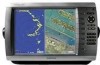
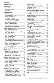
...Unit On or Off 2 Initializing Unit Settings 2 Adjusting the Backlight 3 Acquiring GPS Satellite Signals 3 Inserting and Removing SD Cards 4 Restoring Factory Settings 4 ...Tracks 12 Using BlueChart g2 Vision 14 Using Mariner's Eye 3D 14 Using Fish Eye 3D...and Using Routes 25 Navigating with a Garmin Autopilot 26 Viewing Information 27 Viewing ...Vessels 36 Using the Garmin Marine Network........37 Viewing Connected Garmin Marine Network Devices 38 Using... Contact 49 Viewing the DSC List 50 Receiving Distress Calls 50 Man-Overboard Distress Calls ...Garmin 57 Declaration of Conformity (DoC ...
...Unit On or Off 2 Initializing Unit Settings 2 Adjusting the Backlight 3 Acquiring GPS Satellite Signals 3 Inserting and Removing SD Cards 4 Restoring Factory Settings 4 ...Tracks 12 Using BlueChart g2 Vision 14 Using Mariner's Eye 3D 14 Using Fish Eye 3D...and Using Routes 25 Navigating with a Garmin Autopilot 26 Viewing Information 27 Viewing ...Vessels 36 Using the Garmin Marine Network........37 Viewing Connected Garmin Marine Network Devices 38 Using... Contact 49 Viewing the DSC List 50 Receiving Distress Calls 50 Man-Overboard Distress Calls ...Garmin 57 Declaration of Conformity (DoC ...

Owner's Manual
Page 7
... Minimum Overhead Clearance-select the minimum overhead clearance for your boat specifications for more information. Select Backlight. For more information about GPS, visit the Garmin® Web site at the top of the Home screen are green . When the unit loses satellite signals, the green .... To manually adjust the backlight, either select Up or Down, use the ROCKER (GPSMAP 4000 series), or touch and drag the brightness bar (GPSMAP 5000 series). Refer to automatically adjust the backlight based on , the GPS receiver must collect satellite data and establish its current location...
... Minimum Overhead Clearance-select the minimum overhead clearance for your boat specifications for more information. Select Backlight. For more information about GPS, visit the Garmin® Web site at the top of the Home screen are green . When the unit loses satellite signals, the green .... To manually adjust the backlight, either select Up or Down, use the ROCKER (GPSMAP 4000 series), or touch and drag the brightness bar (GPSMAP 5000 series). Refer to automatically adjust the backlight based on , the GPS receiver must collect satellite data and establish its current location...
Owner's Manual
Page 8
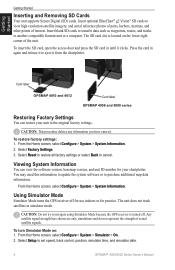
... Select Reset to restore all factory settings or select Back to another compatible Garmin unit or a computer. Viewing System Information You can restore your chartplotter. Using Simulator Mode Simulator Mode turns the GPS receiver off . The unit does not track satellites in again and release it ...satellite imagery, and aerial reference photos of ports, harbors, marinas, and other points of actual satellite signals. Card label GPSMAP 4010 and 4012 Card label GPSMAP 4008 and 5000 series Restoring Factory Settings You can view the software version, basemap version, and unit ID number for...
... Select Reset to restore all factory settings or select Back to another compatible Garmin unit or a computer. Viewing System Information You can restore your chartplotter. Using Simulator Mode Simulator Mode turns the GPS receiver off . The unit does not track satellites in again and release it ...satellite imagery, and aerial reference photos of ports, harbors, marinas, and other points of actual satellite signals. Card label GPSMAP 4010 and 4012 Card label GPSMAP 4008 and 5000 series Restoring Factory Settings You can view the software version, basemap version, and unit ID number for...
Owner's Manual
Page 39
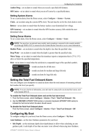
...the system (GPS) clock. Water Temp-set an alarm to an external fuel sensor, such as the Garmin GFS 10. sounds an alarm for the clock alarm to receive sonar information.... The unit must have an optional sonar module (and a transducer connected to the sounder module) wired through NMEA 0183 or connected to the Garmin Marine... set a sonar alarm, from the Home screen, select Configure > Alarms > System. GPSMAP® 4000/5000 Series Owner's Manual 35 Configuring the Chartplotter Anchor Drag-set an alarm...
...the system (GPS) clock. Water Temp-set an alarm to an external fuel sensor, such as the Garmin GFS 10. sounds an alarm for the clock alarm to receive sonar information.... The unit must have an optional sonar module (and a transducer connected to the sounder module) wired through NMEA 0183 or connected to the Garmin Marine... set a sonar alarm, from the Home screen, select Configure > Alarms > System. GPSMAP® 4000/5000 Series Owner's Manual 35 Configuring the Chartplotter Anchor Drag-set an alarm...

Owner's Manual
Page 50
...temperature-capable transducer, the Temp Log screen keeps a graphic log of temperature readings over time. Depth, temperature, and water speed GPS speed and GPS heading Range Transducer frequencies Understanding the Temp Log If you are shown in the upper-left corner. Temperature and depth Time elapsed ...along the right side and the time elapsed appears along the bottom. Using Sonar 46 GPSMAP® 4000/5000 Series Owner's Manual A 200 kHz frequency graph appears on the left as information is received. From the Home screen, select Sonar > Temp Log. From the Home screen, ...
...temperature-capable transducer, the Temp Log screen keeps a graphic log of temperature readings over time. Depth, temperature, and water speed GPS speed and GPS heading Range Transducer frequencies Understanding the Temp Log If you are shown in the upper-left corner. Temperature and depth Time elapsed ...along the right side and the time elapsed appears along the bottom. Using Sonar 46 GPSMAP® 4000/5000 Series Owner's Manual A 200 kHz frequency graph appears on the left as information is received. From the Home screen, select Sonar > Temp Log. From the Home screen, ...
Owner's Manual
Page 53
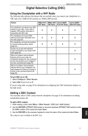
NMEA 0183 VHF Radio X X X NMEA 2000 Garmin NMEA VHF Radio 0183 VHF Radio X X X X X X Garmin NMEA 2000 VHF Radio X X X X X X To turn it on the radar screen. Adding a DSC Contact You can receive DSC distress and position information from the chartplotter. If you are available when you ...for information on configuring how DSC information displays on or off : 1. Use the ROCKER (GPSMAP 4000 series) or onscreen keyboard (GPSMAP 5000 series) to your radio is capable, GPS position information is now available in the DSC List. The contact is transmitted with a VHF...
NMEA 0183 VHF Radio X X X NMEA 2000 Garmin NMEA VHF Radio 0183 VHF Radio X X X X X X Garmin NMEA 2000 VHF Radio X X X X X X To turn it on the radar screen. Adding a DSC Contact You can receive DSC distress and position information from the chartplotter. If you are available when you ...for information on configuring how DSC information displays on or off : 1. Use the ROCKER (GPSMAP 4000 series) or onscreen keyboard (GPSMAP 5000 series) to your radio is capable, GPS position information is now available in the DSC List. The contact is transmitted with a VHF...
Owner's Manual
Page 57
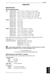
... parallel channel WAAS-capable receiver Acquisition Times: Warm: 15 seconds Cold: 45 seconds AutoLocate: 2 minutes Update Rate: 1/second, continuous GPS Accuracy: Position: Appendix Appendix Specifications Physical Specifications Size: GPSMAP 4008: 7" H × 11.2" W × 4.2" D (176.9 × 284.4 × 106 mm) GPSMAP 4010: 8.9" H × 13.4" W × 4.13" D (226.9 × 340.4 × 105.1 mm) GPSMAP 4012: 9.47" H × 14...
... parallel channel WAAS-capable receiver Acquisition Times: Warm: 15 seconds Cold: 45 seconds AutoLocate: 2 minutes Update Rate: 1/second, continuous GPS Accuracy: Position: Appendix Appendix Specifications Physical Specifications Size: GPSMAP 4008: 7" H × 11.2" W × 4.2" D (176.9 × 284.4 × 106 mm) GPSMAP 4010: 8.9" H × 13.4" W × 4.13" D (226.9 × 340.4 × 105.1 mm) GPSMAP 4012: 9.47" H × 14...
Owner's Manual
Page 59
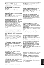
... calculate the route, select a closer end point. DSC Position Report Received From -a position report has been received by the NMEA 2000 network. Contact Garmin Product Support. GPS Service Lost-the unit has lost communications with the remote GPS unit. Invalid System Instance. Lost Heading Sensor Connection- (radar/NMEA).... Contact product support. Cooling Fan Voltage Too Low-the cooling-fan voltage is outside the user-set value. GPSMAP® 4000/5000 Series Owner's Manual Appendix Deep Water Alarm-(sonar) the boat has entered userdefined value for blockage and calibrate again...
... calculate the route, select a closer end point. DSC Position Report Received From -a position report has been received by the NMEA 2000 network. Contact Garmin Product Support. GPS Service Lost-the unit has lost communications with the remote GPS unit. Invalid System Instance. Lost Heading Sensor Connection- (radar/NMEA).... Contact product support. Cooling Fan Voltage Too Low-the cooling-fan voltage is outside the user-set value. GPSMAP® 4000/5000 Series Owner's Manual Appendix Deep Water Alarm-(sonar) the boat has entered userdefined value for blockage and calibrate again...
Owner's Manual
Page 62
...devices connected to optional NMEA 0183-compliant devices, see the GPSMAP 4000/5000 Series Installation Instructions. The GPSMAP 4000 and GPSMAP 5000 series chartplotters can receive data from up to four NMEA 0183-compliant devices and send GPS data to up to see a list of supported NMEA 2000... and can receive data from a NMEA 2000 network installed on your boat. Approved NMEA 0183 Sentences GPBWC, GPRMC, GPGGA, GPGSA, GPGSV, GPGLL, GPBOD, GPRMB, GPRTE, GPVTG, GPWPL, GPXTE, and Garmin proprietary sentences-PGRME, PGRMM, and PGRMZ. To connect a GPSMAP 4000 or GPSMAP 5000 series ...
...devices connected to optional NMEA 0183-compliant devices, see the GPSMAP 4000/5000 Series Installation Instructions. The GPSMAP 4000 and GPSMAP 5000 series chartplotters can receive data from up to four NMEA 0183-compliant devices and send GPS data to up to see a list of supported NMEA 2000... and can receive data from a NMEA 2000 network installed on your boat. Approved NMEA 0183 Sentences GPBWC, GPRMC, GPGGA, GPGSA, GPGSV, GPGLL, GPBOD, GPRMB, GPRTE, GPVTG, GPWPL, GPXTE, and Garmin proprietary sentences-PGRME, PGRMM, and PGRMZ. To connect a GPSMAP 4000 or GPSMAP 5000 series ...


