
Owner's Manual
Page 2
... grants permission to download a single copy of this manual onto a hard drive or other Garmin products. Garmin®, GPSMAP®, AutoLocate®, TracBack®, BlueChart®, MapSource®, and See-Thru® are trademarks of such changes or improvements. November 2007 Part Number 190-00462-00 ..., Taipei County, Taiwan Tel. 886/2.2642.9199 Fax 886/2.2642.9099 All rights reserved. Garmin reserves the right to be used without notice. Visit the Garmin Web site (www.garmin.com) for any purpose without obligation to make changes in this manual or any unauthorized commercial...
... grants permission to download a single copy of this manual onto a hard drive or other Garmin products. Garmin®, GPSMAP®, AutoLocate®, TracBack®, BlueChart®, MapSource®, and See-Thru® are trademarks of such changes or improvements. November 2007 Part Number 190-00462-00 ..., Taipei County, Taiwan Tel. 886/2.2642.9199 Fax 886/2.2642.9099 All rights reserved. Garmin reserves the right to be used without notice. Visit the Garmin Web site (www.garmin.com) for any purpose without obligation to make changes in this manual or any unauthorized commercial...

Owner's Manual
Page 18
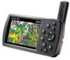
... 169 in a data field: 1. MapSource Detailed Maps Optional Garmin data cards and MapSource CD-ROMs enhance the versatility of data, keep pressing right to drop to the Garmin Web site at www.garmin.com/cartography. 10 GPSMAP 396 Owner's Manual For compatible MapSource products, refer to the next line.... 3. Getting Started > Using the GPSMAP 396 To enter data in the "Appendix" for any listed ...
... 169 in a data field: 1. MapSource Detailed Maps Optional Garmin data cards and MapSource CD-ROMs enhance the versatility of data, keep pressing right to drop to the Garmin Web site at www.garmin.com/cartography. 10 GPSMAP 396 Owner's Manual For compatible MapSource products, refer to the next line.... 3. Getting Started > Using the GPSMAP 396 To enter data in the "Appendix" for any listed ...

Owner's Manual
Page 37
...scales from 20 ft to 800 nm (20 ft to 800 mi or 5 m to open the Map Page. The system uses optional MapSource City Navigator for information. GPSMAP 396 Owner's Manual 29 No additional data available • When optional City Select map data is shown. • When the selected zoom ...of the BlueChart, or MapSource software. Select Set up Map, and press Enter. Note: The range value represents the distance between the ends of the range bar ( ). Press Menu. Using the optional City Navigator maps. Refer to page 33 for street level mapping data. Aviation Mode Pages > Map Page...
...scales from 20 ft to 800 nm (20 ft to 800 mi or 5 m to open the Map Page. The system uses optional MapSource City Navigator for information. GPSMAP 396 Owner's Manual 29 No additional data available • When optional City Select map data is shown. • When the selected zoom ...of the BlueChart, or MapSource software. Select Set up Map, and press Enter. Note: The range value represents the distance between the ends of the range bar ( ). Press Menu. Using the optional City Navigator maps. Refer to page 33 for street level mapping data. Aviation Mode Pages > Map Page...
Owner's Manual
Page 85
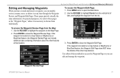
...access the Waypoint Review Page from the list. Points Tab in the Main Menu 3. If the waypoint is located on a map feature or MapSource or BlueChart feature, the Waypoint Review Page can include additional tabs containing information about the other map features. Use the ROCKER to open the ... highlight the waypoint from the Map: 1. Waypoint Review Page GPSMAP 396 Owner's Manual 77 Use the ROCKER to access the Waypoint Page so you can modify, review, rename, move, or delete it is located on a map feature or MapSource or BlueChart feature, the Waypoint Edit Page does NOT show ...
...access the Waypoint Review Page from the list. Points Tab in the Main Menu 3. If the waypoint is located on a map feature or MapSource or BlueChart feature, the Waypoint Review Page can include additional tabs containing information about the other map features. Use the ROCKER to open the ... highlight the waypoint from the Map: 1. Waypoint Review Page GPSMAP 396 Owner's Manual 77 Use the ROCKER to access the Waypoint Page so you can modify, review, rename, move, or delete it is located on a map feature or MapSource or BlueChart feature, the Waypoint Edit Page does NOT show ...

Owner's Manual
Page 91
... to delete. 2. Use the ROCKER to a computer using the USB cable and software, such as MapSource, or write the coordinates down by hand. To access the Points tab: 1. Press Menu, highlight Delete Waypoint, and press Enter. 3. GPSMAP 396 Owner's Manual 83 Press Direct To . Press menu twice to open the Main Menu. 2. Highlight...
... to delete. 2. Use the ROCKER to a computer using the USB cable and software, such as MapSource, or write the coordinates down by hand. To access the Points tab: 1. Press Menu, highlight Delete Waypoint, and press Enter. 3. GPSMAP 396 Owner's Manual 83 Press Direct To . Press menu twice to open the Main Menu. 2. Highlight...

Owner's Manual
Page 163
... components. It can occur (such as in the trunk of a car) as waypoints and routes, is waterproof to MapSource). After submersion, be certain to www.garmin.com/support. Immersing the Unit in Water The GPSMAP 396 is retained in 1 meter of high quality materials and does not require user maintenance other than cleaning. It...
... components. It can occur (such as in the trunk of a car) as waypoints and routes, is waterproof to MapSource). After submersion, be certain to www.garmin.com/support. Immersing the Unit in Water The GPSMAP 396 is retained in 1 meter of high quality materials and does not require user maintenance other than cleaning. It...
Owner's Manual
Page 164
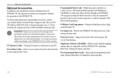
...designed to enhance the operation of the unit to protect the screen from MapSource CD-ROMs to a data card, either Garmin BlueChart or Fishing Hot Spots map data. 156 GPSMAP 396 Owner's Manual or Garmin (Europe) Ltd. Programmable Data Cards-Blank data cards available in use;... and specifically tested for use with Garmin products. Download detailed map data from damage. WARNING: Garmin accessories have not been tested or approved for use with Garmin products. To obtain replacement parts and optional accessories, contact your GPSMAP 396 using the bare wires. Power/Data...
...designed to enhance the operation of the unit to protect the screen from MapSource CD-ROMs to a data card, either Garmin BlueChart or Fishing Hot Spots map data. 156 GPSMAP 396 Owner's Manual or Garmin (Europe) Ltd. Programmable Data Cards-Blank data cards available in use;... and specifically tested for use with Garmin products. Download detailed map data from damage. WARNING: Garmin accessories have not been tested or approved for use with Garmin products. To obtain replacement parts and optional accessories, contact your GPSMAP 396 using the bare wires. Power/Data...

Owner's Manual
Page 167
... always detects your computer (see illustration on your GPSMAP 396. GPSMAP 396 Owner's Manual 159 Note: Fully install the supplied MapSource program, Trip & Waypoint Manager, on the bottom left). You only need to the left ). To connect your GPS to your computer before connecting the USB cable to...: 1. You can be connected to your cable to the lower connector on your GPSMAP 396 when it is connected. Connecting Your GPSMAP 396 to a Computer Your GPSMAP 396 can find these updates at www.garmin.com. When using the supplied USB Data Cable, connect the larger end of the...
... always detects your computer (see illustration on your GPSMAP 396. GPSMAP 396 Owner's Manual 159 Note: Fully install the supplied MapSource program, Trip & Waypoint Manager, on the bottom left). You only need to the left ). To connect your GPS to your computer before connecting the USB cable to...: 1. You can be connected to your cable to the lower connector on your GPSMAP 396 when it is connected. Connecting Your GPSMAP 396 to a Computer Your GPSMAP 396 can find these updates at www.garmin.com. When using the supplied USB Data Cable, connect the larger end of the...

Owner's Manual
Page 168
... BlueChart and MapSource detailed maps in a MapSource program. Firmly push the card into the slot on the bottom of the unit. It is still not recognized, contact Garmin Product Support or your GPS unit. You can load a variety of external devices: GARMIN proprietary Differential GPS (DGPS), NMEA 0180, 0182, 0183 (versions 1.5, 2.0, 2.3, 3.01), ASCII Text Output, GPSMAP 396 Owner...
... BlueChart and MapSource detailed maps in a MapSource program. Firmly push the card into the slot on the bottom of the unit. It is still not recognized, contact Garmin Product Support or your GPS unit. You can load a variety of external devices: GARMIN proprietary Differential GPS (DGPS), NMEA 0180, 0182, 0183 (versions 1.5, 2.0, 2.3, 3.01), ASCII Text Output, GPSMAP 396 Owner...

Owner's Manual
Page 178
...received from the external sonar device. Flash Flood Warning-a flash flood warning was found. Memory Full-unit memory is deeper than the amount set value. Near Proximity Point-you are not accessible. Alarm Clock-the alarm clock has sounded. All MapSource...Contact Garmin Product Support. Marine Warning-a marine warning was received. NMEA Depth is not moving fast enough for one minute of final VNAV target altitude. GPSMAP 396 ... calculation. Boat Is Not Moving Fast Enough to Ground-the external GPS antenna has an electrical connection problem. Check XM Antenna-internal problem...
...received from the external sonar device. Flash Flood Warning-a flash flood warning was found. Memory Full-unit memory is deeper than the amount set value. Near Proximity Point-you are not accessible. Alarm Clock-the alarm clock has sounded. All MapSource...Contact Garmin Product Support. Marine Warning-a marine warning was received. NMEA Depth is not moving fast enough for one minute of final VNAV target altitude. GPSMAP 396 ... calculation. Boat Is Not Moving Fast Enough to Ground-the external GPS antenna has an electrical connection problem. Check XM Antenna-internal problem...

Owner's Manual
Page 189
...menu Display Tab 113 GPS tab 4 Sound Tab 114 Man OverBoard 91 map information 35, 59 MapSource 10, 160 map datum 166 map orientation 29 Map Page automotive mode 68 aviation mode 28-35 ...declutter 32 marine mode 92 setup 33 marine timer 94 maritime mobile service identity. See simulator mode preferences location 166 pressure 119 proximity 85 alarms 85 points tab 84 waypoint 85 R receiver... preference 116 reviewing 74 saving the current 71 GPSMAP 396 Owner's Manual 181
...menu Display Tab 113 GPS tab 4 Sound Tab 114 Man OverBoard 91 map information 35, 59 MapSource 10, 160 map datum 166 map orientation 29 Map Page automotive mode 68 aviation mode 28-35 ...declutter 32 marine mode 92 setup 33 marine timer 94 maritime mobile service identity. See simulator mode preferences location 166 pressure 119 proximity 85 alarms 85 points tab 84 waypoint 85 R receiver... preference 116 reviewing 74 saving the current 71 GPSMAP 396 Owner's Manual 181


