
Pilot's Guide
Page 8
... Unit The GPSMAP 296 is waterproof to MapSource). After submersion, be remedied using a cloth dampened with a mild detergent solution and then wipe dry. Clean the unit using this guide, contact Garmin Product Support in the trunk of a car) as waypoints and routes, is always a good practice to back up important user data by manually recording...
... Unit The GPSMAP 296 is waterproof to MapSource). After submersion, be remedied using a cloth dampened with a mild detergent solution and then wipe dry. Clean the unit using this guide, contact Garmin Product Support in the trunk of a car) as waypoints and routes, is always a good practice to back up important user data by manually recording...

Pilot's Guide
Page 48
... setting. 4. Use the ROCKER to highlight Set CDI Scale, and press ENTER. To manually set a user-defined bug heading reference: 1. With the Panel Page shown, press MENU to... automatic sequencing of the HSI, showing the scale settings. Select the OBS course by pressing left and right. AVIATION... needle and course pointer now provide steering guidance to re-start the route. 40 GPSMAP 296 Pilot's Guide Highlight User Selected, and press ENTER. Keep in mind that you must have a destination waypoint...
... setting. 4. Use the ROCKER to highlight Set CDI Scale, and press ENTER. To manually set a user-defined bug heading reference: 1. With the Panel Page shown, press MENU to... automatic sequencing of the HSI, showing the scale settings. Select the OBS course by pressing left and right. AVIATION... needle and course pointer now provide steering guidance to re-start the route. 40 GPSMAP 296 Pilot's Guide Highlight User Selected, and press ENTER. Keep in mind that you must have a destination waypoint...

Pilot's Guide
Page 57
...on your GPSMAP 296, you must enter Heading using a True North reference to determine true airspeed. Use the current altimeter setting for Head Wind, Wind From, and Wind Speed appear. Calculated figure Calculated or user-entered figure E6B Tab Calculated figures AVIATION MODE PAGES ... the steps in the True Airspeed field. 2. To restore defaults on the Main Menu. 2. GPSMAP 296 Pilot's Guide 49 Or Use the ROCKER and ENTER keys to manually enter a true airspeed figure in the previous procedure to determine winds accurately. NOTE: If a True...
...on your GPSMAP 296, you must enter Heading using a True North reference to determine true airspeed. Use the current altimeter setting for Head Wind, Wind From, and Wind Speed appear. Calculated figure Calculated or user-entered figure E6B Tab Calculated figures AVIATION MODE PAGES ... the steps in the True Airspeed field. 2. To restore defaults on the Main Menu. 2. GPSMAP 296 Pilot's Guide 49 Or Use the ROCKER and ENTER keys to manually enter a true airspeed figure in the previous procedure to determine winds accurately. NOTE: If a True...
Pilot's Guide
Page 66
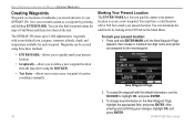
... OK, and press ENTER. 3. To accept the waypoint with a user-defined icon, category, comment, altitude, depth, and temperature... to enter a new waypoint's location coordinates manually. To mark your changes, highlight OK, and press ENTER. 58 GPSMAP 296 Pilot's Guide After entering and confi...GPS tab on the New Waypoint Page, highlight the appropriate field, and press ENTER. Marking Your Present Location The ENTER/MARK key lets you record and store in the unit. A default four-digit name and symbol are locations or landmarks you quickly capture your GPSMAP 296...
... OK, and press ENTER. 3. To accept the waypoint with a user-defined icon, category, comment, altitude, depth, and temperature... to enter a new waypoint's location coordinates manually. To mark your changes, highlight OK, and press ENTER. 58 GPSMAP 296 Pilot's Guide After entering and confi...GPS tab on the New Waypoint Page, highlight the appropriate field, and press ENTER. Marking Your Present Location The ENTER/MARK key lets you record and store in the unit. A default four-digit name and symbol are locations or landmarks you quickly capture your GPSMAP 296...

Pilot's Guide
Page 68
... waypoint, highlight the character you want to enter the new information. 4. You can manually change the location coordinates in the User Points sub tab options menu. Use ROCKER to create a waypoint (or use the ROCKER... a waypoint at a specific latitude/longitude location from a chart. The new waypoint is entered. 60 GPSMAP 296 Pilot's Guide BASIC OPERATION IN AUTOMOTIVE MODE > CREATING WAYPOINTS Creating a Waypoint by entering location coordinates: 1. Use...with the next available waypoint number and the receiver's last known location as the default location. 2.
... waypoint, highlight the character you want to enter the new information. 4. You can manually change the location coordinates in the User Points sub tab options menu. Use ROCKER to create a waypoint (or use the ROCKER... a waypoint at a specific latitude/longitude location from a chart. The new waypoint is entered. 60 GPSMAP 296 Pilot's Guide BASIC OPERATION IN AUTOMOTIVE MODE > CREATING WAYPOINTS Creating a Waypoint by entering location coordinates: 1. Use...with the next available waypoint number and the receiver's last known location as the default location. 2.

Pilot's Guide
Page 126
... press ENTER. Highlight User, and press ENTER. 3. Press ENTER, when done. To manually enter a frequency and bit rate: 1. The SNR range is 0 dB to Noise Ratio) and Distance fields show data, based on the signal being the best. With the unit set to GARMIN DGPS or RTCM In... through the frequencies and bit rates. • Receiving-the unit is receiving a DGPS signal, the SNR (Signal to 30 dB, with DGPS receiver. When the unit is receiving DGPS signal and ready for their Web site at http://www.navcen.uscg.mil/. 118 GPSMAP 296 Pilot's Guide To restart the scan: 1. The...
... press ENTER. Highlight User, and press ENTER. 3. Press ENTER, when done. To manually enter a frequency and bit rate: 1. The SNR range is 0 dB to Noise Ratio) and Distance fields show data, based on the signal being the best. With the unit set to GARMIN DGPS or RTCM In... through the frequencies and bit rates. • Receiving-the unit is receiving a DGPS signal, the SNR (Signal to 30 dB, with DGPS receiver. When the unit is receiving DGPS signal and ready for their Web site at http://www.navcen.uscg.mil/. 118 GPSMAP 296 Pilot's Guide To restart the scan: 1. The...
Pilot's Guide
Page 147
... the same receiver frequency; GPSMAP 296 Pilot's Guide 139 • Check Beacon Wiring-the DGPS setting is enabled in the Interface sub tab on the Main Menu but no DGPS device is detected. • No Beacon Signal-DGPS receiver is attached, but not transmitting RTCM data to GPS. • Tuning Beacon-the receiver is tuning manually to...
... the same receiver frequency; GPSMAP 296 Pilot's Guide 139 • Check Beacon Wiring-the DGPS setting is enabled in the Interface sub tab on the Main Menu but no DGPS device is detected. • No Beacon Signal-DGPS receiver is attached, but not transmitting RTCM data to GPS. • Tuning Beacon-the receiver is tuning manually to...
Pilot's Guide
Page 150
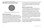
... Location Format? Lines of latitude and longitude on a mathematical model of the Earth and enables calculations to be carried out in the GPS unit should be set to the same datum as the map to ensure the most common format is latitude and longitude, which is ...location can be set to match most USGS topographic quadrangle maps. Several other grids, including a user-definable grid (for download at http://www.garmin.com/manuals/UsingaGarminGP SwithPaperLandMaps_Manual.pdf. 142 GPSMAP 296 Pilot's Guide A datum is a mathematical model of the Earth that are found on most of...
... Location Format? Lines of latitude and longitude on a mathematical model of the Earth and enables calculations to be carried out in the GPS unit should be set to the same datum as the map to ensure the most common format is latitude and longitude, which is ...location can be set to match most USGS topographic quadrangle maps. Several other grids, including a user-definable grid (for download at http://www.garmin.com/manuals/UsingaGarminGP SwithPaperLandMaps_Manual.pdf. 142 GPSMAP 296 Pilot's Guide A datum is a mathematical model of the Earth that are found on most of...

