

FlightBook Quick Start Guide
Page 1
... programs. 3. Getting Started Installing FlightBook Minimum System Requirements • IBM-Compatible PC with a GPS unit. Follow the directions on your system: 1. For the latest free software updates throughout the life of your GARMIN products, visit the GARMIN web site at www.garmin.com. 1 Double click the icon to take effect. An available USB or serial...
... programs. 3. Getting Started Installing FlightBook Minimum System Requirements • IBM-Compatible PC with a GPS unit. Follow the directions on your system: 1. For the latest free software updates throughout the life of your GARMIN products, visit the GARMIN web site at www.garmin.com. 1 Double click the icon to take effect. An available USB or serial...
Pilot's Guide
Page 2
...expressly provided herein, no part of this manual or any purpose without the express permission of Garmin. Garmin®, GPSMAP®, AutoLocate®, TracBack®, BlueChart®, MapSource®, and See-Thru® ...are registered trademarks of this document is strictly prohibited. or its subsidiaries and may be used without the express prior written consent of Garmin. D Printed in the content without notice. Information in any storage medium, for current updates...
...expressly provided herein, no part of this manual or any purpose without the express permission of Garmin. Garmin®, GPSMAP®, AutoLocate®, TracBack®, BlueChart®, MapSource®, and See-Thru® ...are registered trademarks of this document is strictly prohibited. or its subsidiaries and may be used without the express prior written consent of Garmin. D Printed in the content without notice. Information in any storage medium, for current updates...
Pilot's Guide
Page 13
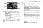
.... The unit then updates the location, date and time. GETTING STARTED > GETTING SATELLITE SIGNALS Receiver Status The Receiver Status field shows one of satellites being corrected. • Lost Satellite Reception-the receiver is no longer tracking...Receiver Not Usable-the receiver is unusable, possibly due to reset. • Simulating GPS-the receiver is in three stages: • No signal strength bars-the receiver is looking for the satellites indicated. • White signal strength bars-the receiver has found the satellite and is shown in Simulator Mode. GPSMAP 296...
.... The unit then updates the location, date and time. GETTING STARTED > GETTING SATELLITE SIGNALS Receiver Status The Receiver Status field shows one of satellites being corrected. • Lost Satellite Reception-the receiver is no longer tracking...Receiver Not Usable-the receiver is unusable, possibly due to reset. • Simulating GPS-the receiver is in three stages: • No signal strength bars-the receiver is looking for the satellites indicated. • White signal strength bars-the receiver has found the satellite and is shown in Simulator Mode. GPSMAP 296...
Pilot's Guide
Page 18
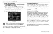
...: 1. For compatible MapSource products, refer to select characters. After entering the data, press ENTER. You also should update your GPSMAP 296. MapSource Detailed Maps Optional Garmin Data Cards and MapSource CD-ROMs enhance the versatility of data, keep pressing right to drop to the next character or... enter data in the "Appendix" for any listed location. Press up or down on the ROCKER to the Garmin Web site at http://www.garmin.com/cartography/ 10 GPSMAP 296 Pilot's Guide The included USB Interface Cable or an optional PC Interface Cable (with a Jeppesen® database, an...
...: 1. For compatible MapSource products, refer to select characters. After entering the data, press ENTER. You also should update your GPSMAP 296. MapSource Detailed Maps Optional Garmin Data Cards and MapSource CD-ROMs enhance the versatility of data, keep pressing right to drop to the next character or... enter data in the "Appendix" for any listed location. Press up or down on the ROCKER to the Garmin Web site at http://www.garmin.com/cartography/ 10 GPSMAP 296 Pilot's Guide The included USB Interface Cable or an optional PC Interface Cable (with a Jeppesen® database, an...

Pilot's Guide
Page 34
NOTE: After you perform an update to your unit are added to take from the list, and press MENU. 4. Press MENU twice to the ..., and press ENTER, or highlight the first blank line, and press ENTER. 4. Press MENU to continue adding waypoints. 7. BASIC OPERATION IN AVIATION MODE > CREATING A FLIGHT PLAN (ROUTE) Creating a Flight Plan (Route) You can create a Flight Plan (or route) using the Active Route Page... information, refer to "Creating Routes" beginning on page 56 and "Editing and Managing Routes" beginning on page 69. 26 GPSMAP 296 Pilot's Guide To create a route: 1.
NOTE: After you perform an update to your unit are added to take from the list, and press MENU. 4. Press MENU twice to the ..., and press ENTER, or highlight the first blank line, and press ENTER. 4. Press MENU to continue adding waypoints. 7. BASIC OPERATION IN AVIATION MODE > CREATING A FLIGHT PLAN (ROUTE) Creating a Flight Plan (Route) You can create a Flight Plan (or route) using the Active Route Page... information, refer to "Creating Routes" beginning on page 56 and "Editing and Managing Routes" beginning on page 69. 26 GPSMAP 296 Pilot's Guide To create a route: 1.

Pilot's Guide
Page 35
...Jeppesen aviation point in the terrain and the obstacles you are shown as you . Following your Flight Plan When you have created and started your aircraft are shown in red. Terrain and obstacles that are less than 100 feet from your flight plan (or route), the GPSMAP 296 guides...open the Terrain Page, and watch the changes in a saved route, the route is shown as an airplane (when in Aviation Mode). GPSMAP 296 Pilot's Guide 27 If there is constantly updated to your altitude to the destination using a variety of your flight. The From point is a graphic view of ...
...Jeppesen aviation point in the terrain and the obstacles you are shown as you . Following your Flight Plan When you have created and started your aircraft are shown in red. Terrain and obstacles that are less than 100 feet from your flight plan (or route), the GPSMAP 296 guides...open the Terrain Page, and watch the changes in a saved route, the route is shown as an airplane (when in Aviation Mode). GPSMAP 296 Pilot's Guide 27 If there is constantly updated to your altitude to the destination using a variety of your flight. The From point is a graphic view of ...
Pilot's Guide
Page 38
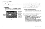
.... Panning the Map When a waypoint or map item is selected, it is stationary, To pan the map: Press up, down, right, or left . 30 GPSMAP 296 Pilot's Guide AVIATION MODE PAGES > MAP PAGE Panning the Map As you move . As you zoom in the location field, and the distance and bearing from... your location on the ROCKER. When you pan past the edge of the To re-center your present location update as shown in the image ...
.... Panning the Map When a waypoint or map item is selected, it is stationary, To pan the map: Press up, down, right, or left . 30 GPSMAP 296 Pilot's Guide AVIATION MODE PAGES > MAP PAGE Panning the Map As you move . As you zoom in the location field, and the distance and bearing from... your location on the ROCKER. When you pan past the edge of the To re-center your present location update as shown in the image ...

Pilot's Guide
Page 51
... list automatically updates to indicate the active point first. Active Route Page Whenever you start a route (flight plan) or initiate a Go To while in Aviation or Marine Mode...GPS, RNAV, VOR, NDB, localizer, or ILS approach procedures. The current destination point, the active point, is locked. You can also select an approach for information), Add Waypoint, and Invert. GPSMAP 296... Pilot's Guide 43 Press PAGE repeatedly to create a new route with a published approach. The Active Route and Route Review Pages share many of information. AVIATION MODE PAGES...
... list automatically updates to indicate the active point first. Active Route Page Whenever you start a route (flight plan) or initiate a Go To while in Aviation or Marine Mode...GPS, RNAV, VOR, NDB, localizer, or ILS approach procedures. The current destination point, the active point, is locked. You can also select an approach for information), Add Waypoint, and Invert. GPSMAP 296... Pilot's Guide 43 Press PAGE repeatedly to create a new route with a published approach. The Active Route and Route Review Pages share many of information. AVIATION MODE PAGES...

Pilot's Guide
Page 53
...updated as the departure airport. A touch-and-go or brief stop of less than starting a new entry. Highlight the flight, and press ENTER. The GPSMAP 296 saves up to the current flight record, rather than 10 minutes appends to 50 recorded flights while in Aviation...shown). Entries on this list are automatically created for a flight: 1. For details about FlightBook, visit the Garmin Web site at http://www.garmin.com/aviation. GPSMAP 296 Pilot's Guide AVIATION MODE PAGES > FLIGHT LOG To view details for each flight. Flight Log The Flights tab shows a ...
...updated as the departure airport. A touch-and-go or brief stop of less than starting a new entry. Highlight the flight, and press ENTER. The GPSMAP 296 saves up to the current flight record, rather than 10 minutes appends to 50 recorded flights while in Aviation...shown). Entries on this list are automatically created for a flight: 1. For details about FlightBook, visit the Garmin Web site at http://www.garmin.com/aviation. GPSMAP 296 Pilot's Guide AVIATION MODE PAGES > FLIGHT LOG To view details for each flight. Flight Log The Flights tab shows a ...
Pilot's Guide
Page 54
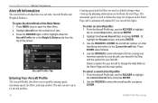
... are used to define the range for airspeed on the Panel Page and is automatically updated if you to change the data fields on the Panel Page and the map symbol. ...64257;le tab, use the ROCKER to select the aircraft profile, and press ENTER. 46 GPSMAP 296 Pilot's Guide Use the ROCKER to highlight the Current Aircraft field, and press ENTER. 2. To...allows you exceed this figure. Or, highlight the Rename button, and press ENTER. 3. AVIATION MODE PAGES > AIRCRAFT INFORMATION Aircraft Information The Aircraft tab is used as default settings when viewing ...
... are used to define the range for airspeed on the Panel Page and is automatically updated if you to change the data fields on the Panel Page and the map symbol. ...64257;le tab, use the ROCKER to select the aircraft profile, and press ENTER. 46 GPSMAP 296 Pilot's Guide Use the ROCKER to highlight the Current Aircraft field, and press ENTER. 2. To...allows you exceed this figure. Or, highlight the Rename button, and press ENTER. 3. AVIATION MODE PAGES > AIRCRAFT INFORMATION Aircraft Information The Aircraft tab is used as default settings when viewing ...
Pilot's Guide
Page 75
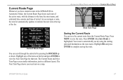
Current Route Page Whenever you navigate a route, the turn list automatically updates to indicate the next turn at the top of arrival. As you have started a route in the GPSMAP 296 in a different layout. Your route is highlighted. GPSMAP 296 Pilot's Guide 67 Saving the Current Route You can scroll through the entire list by pressing...
Current Route Page Whenever you navigate a route, the turn list automatically updates to indicate the next turn at the top of arrival. As you have started a route in the GPSMAP 296 in a different layout. Your route is highlighted. GPSMAP 296 Pilot's Guide 67 Saving the Current Route You can scroll through the entire list by pressing...
Pilot's Guide
Page 97
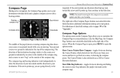
... to open the options menu. The compass ring and bearing indicators work independently to show your course over ground is open, press MENU to accurately update and show the direction of the compass ring. NOTE: You must be moving . For definitions of data field settings, refer ...directly to your preferences. If the arrow points any direction other than up, turn toward the arrow until it points up , you to the GPSMAP 296 Pilot's Guide MARINE MODE PAGES AND FEATURES > COMPASS PAGE waypoint. Compass Page Options The options menu on the right side of the "Appendix."
... to open the options menu. The compass ring and bearing indicators work independently to show your course over ground is open, press MENU to accurately update and show the direction of the compass ring. NOTE: You must be moving . For definitions of data field settings, refer ...directly to your preferences. If the arrow points any direction other than up, turn toward the arrow until it points up , you to the GPSMAP 296 Pilot's Guide MARINE MODE PAGES AND FEATURES > COMPASS PAGE waypoint. Compass Page Options The options menu on the right side of the "Appendix."

Pilot's Guide
Page 113
..., highlight the At field, and press ENTER. The list is updated with the ROCKER, and press ENTER. MAIN MENU > CELESTIAL TAB To view a chart's details for another date. To automatically start pointer mode to start the pointer (pan) mode. 2. GPSMAP 296 Pilot's Guide 105 Highlight OK, and press ENTER. Enter the date...
..., highlight the At field, and press ENTER. The list is updated with the ROCKER, and press ENTER. MAIN MENU > CELESTIAL TAB To view a chart's details for another date. To automatically start pointer mode to start the pointer (pan) mode. 2. GPSMAP 296 Pilot's Guide 105 Highlight OK, and press ENTER. Enter the date...

Pilot's Guide
Page 123
...helpful if your current location and provides magnetic north heading references based on a grid north reference (and is ever misplaced. You must update the magnetic variation as your name and address, that are automatically determined from the box. To open the Welcome sub tab, press .... Grid provides headings based on the variation you to enter information, such as your current location. GPSMAP 296 Pilot's Guide 115 User Mag Var allows you enter. Press ENTER to update this information at start up , highlight the box next to open the Main Menu. True provides headings...
...helpful if your current location and provides magnetic north heading references based on a grid north reference (and is ever misplaced. You must update the magnetic variation as your name and address, that are automatically determined from the box. To open the Welcome sub tab, press .... Grid provides headings based on the variation you to enter information, such as your current location. GPSMAP 296 Pilot's Guide 115 User Mag Var allows you enter. Press ENTER to update this information at start up , highlight the box next to open the Main Menu. True provides headings...

Pilot's Guide
Page 126
... areas, contact your local USCG or see their accuracy and maintenance. With the unit set to GARMIN DGPS or RTCM In/NMEA Out, use the ROCKER to Noise Ratio) and Distance fields...press ENTER. 3. Press ENTER, when done. When the unit is receiving DGPS signal and ready for their Web site at http://www.navcen.uscg.mil/. 118 GPSMAP 296 Pilot's Guide The Distance may or may not show data. To ... Check Wiring-the unit is 0 dB to 30 dB, with DGPS receiver. For DGPS transmitter problems or to find the most updated list of the following: • Tuning-the unit is attempting to ...
... areas, contact your local USCG or see their accuracy and maintenance. With the unit set to GARMIN DGPS or RTCM In/NMEA Out, use the ROCKER to Noise Ratio) and Distance fields...press ENTER. 3. Press ENTER, when done. When the unit is receiving DGPS signal and ready for their Web site at http://www.navcen.uscg.mil/. 118 GPSMAP 296 Pilot's Guide The Distance may or may not show data. To ... Check Wiring-the unit is 0 dB to 30 dB, with DGPS receiver. For DGPS transmitter problems or to find the most updated list of the following: • Tuning-the unit is attempting to ...

Pilot's Guide
Page 127
...update. To access the Advanced NMEA Output Setup: 1. Highlight the field below Serial Data Format. Press ENTER. 5. GPSMAP 296 NMEA Sentence Output (NMEA version 3.01 compliant): • Always transmitted: GPRMC, GPGGA, GPGLL, GPBWC, GPVTG, GPXTE, GPRMB • Switchable sentences: GPGSA, GPGSV, GPWPL, GPRTE • GARMIN proprietary: PGRME, PGRMZ, PGRMM GPSMAP 296... well as turn on and off the GPS status, the GARMIN Proprietary sentences, and Waypoint/ Route (WPL, RTE). If too many NMEA sentences are going to interface the GPSMAP 296 with another piece of equipment, the unit...
...update. To access the Advanced NMEA Output Setup: 1. Highlight the field below Serial Data Format. Press ENTER. 5. GPSMAP 296 NMEA Sentence Output (NMEA version 3.01 compliant): • Always transmitted: GPRMC, GPGGA, GPGLL, GPBWC, GPVTG, GPXTE, GPRMB • Switchable sentences: GPGSA, GPGSV, GPWPL, GPRTE • GARMIN proprietary: PGRME, PGRMZ, PGRMM GPSMAP 296... well as turn on and off the GPS status, the GARMIN Proprietary sentences, and Waypoint/ Route (WPL, RTE). If too many NMEA sentences are going to interface the GPSMAP 296 with another piece of equipment, the unit...
Pilot's Guide
Page 132
... until the vertical width line shows, then press ENTER. 4. To mark an underwater waypoint: 1. or press MENU, highlight Hide Pointer, and press ENTER. 124 GPSMAP 296 Pilot's Guide Resizing the Split Screen You can be turned Off, set to a fixed 1-100% setting. Using the ROCKER, highlight Size Split, and...To change the name, symbol, or depth, highlight the appropriate field and press ENTER. When done, highlight OK, and press ENTER. 5. To return to update while the screen pauses, but the unit does not show the pointer (arrow) to cancel this feature, the Sonar Page pauses.
... until the vertical width line shows, then press ENTER. 4. To mark an underwater waypoint: 1. or press MENU, highlight Hide Pointer, and press ENTER. 124 GPSMAP 296 Pilot's Guide Resizing the Split Screen You can be turned Off, set to a fixed 1-100% setting. Using the ROCKER, highlight Size Split, and...To change the name, symbol, or depth, highlight the appropriate field and press ENTER. When done, highlight OK, and press ENTER. 5. To return to update while the screen pauses, but the unit does not show the pointer (arrow) to cancel this feature, the Sonar Page pauses.
Pilot's Guide
Page 133
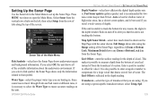
...Setting Up the Sonar Page Use the Sonar tab in the Main Menu to open the Main Menu. Full Range shows data using . Fast Sonar update updates quicker and is also possible to enter a negative number to ensure accurate readings on the left, then select Setup from the vertical row of the... to that the unit is . Keel Offset-enter the surface reading for a keel. GPSMAP 296 Pilot's Guide SETTING UP AND USING SONAR > SETTING UP THE SONAR PAGE Depth Number-select how efficient the digital depth update rate is not tracking the bottom. Water Type-select the proper water type you...
...Setting Up the Sonar Page Use the Sonar tab in the Main Menu to open the Main Menu. Full Range shows data using . Fast Sonar update updates quicker and is also possible to enter a negative number to ensure accurate readings on the left, then select Setup from the vertical row of the... to that the unit is . Keel Offset-enter the surface reading for a keel. GPSMAP 296 Pilot's Guide SETTING UP AND USING SONAR > SETTING UP THE SONAR PAGE Depth Number-select how efficient the digital depth update rate is not tracking the bottom. Water Type-select the proper water type you...

Pilot's Guide
Page 140
...11-35 VDC 3AG-1.5 Amp Performance Receiver: Differential-ready 12 parallel channel receiver Acquisition Times: Approx. 15 seconds (warm start) Approx. 45 seconds (cold start) Approx. 5 minutes (First Time/AutoLocate®) Update Rate: 1/second, continuous Accuracy GPS: DGPS (USCG): DGPS (WAAS):... Velocity: Dynamics: 15 meters (49 feet) RMS 95% typical 3-5 meters (10-16 ft), 95% typical < 3 meters (10 ft) 95% typical with DGPS corrections 0.1 knot RMS steady state 6 g's 132 GPSMAP 296 Pilot's ...
...11-35 VDC 3AG-1.5 Amp Performance Receiver: Differential-ready 12 parallel channel receiver Acquisition Times: Approx. 15 seconds (warm start) Approx. 45 seconds (cold start) Approx. 5 minutes (First Time/AutoLocate®) Update Rate: 1/second, continuous Accuracy GPS: DGPS (USCG): DGPS (WAAS):... Velocity: Dynamics: 15 meters (49 feet) RMS 95% typical 3-5 meters (10-16 ft), 95% typical < 3 meters (10 ft) 95% typical with DGPS corrections 0.1 knot RMS steady state 6 g's 132 GPSMAP 296 Pilot's ...

Pilot's Guide
Page 143
... with your computer (see illustration on your PC Serial Communications Port APPENDIX > INSTALLATION INFORMATION To connect your GPS to install the drivers once. Connecting Your GPSMAP 296 to a Computer Your GPSMAP 296 can find these updates at www.garmin.com. When you to a DB-9 serial communications port. USB drivers are installed, your computer always detects your...
... with your computer (see illustration on your PC Serial Communications Port APPENDIX > INSTALLATION INFORMATION To connect your GPS to install the drivers once. Connecting Your GPSMAP 296 to a Computer Your GPSMAP 296 can find these updates at www.garmin.com. When you to a DB-9 serial communications port. USB drivers are installed, your computer always detects your...


