Owner's Manual
Page 7
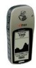
...;ve user-Buttons. It is a six ounce, 12 channel, hand held GPS receiver. All Buttons are , where you've been and where you with name and graphic symbol. The eTrex Summit contains a full function GPS, electronic compass and barometric altimeter. Other features include: Waypoints: 500 with more...; 10 saved tracks. From these technologies you'll know the way back home, you can provide one -handed operation that let you set of the display. Elevation Computer: Total ascent, total descent, average ascent, average descent, maximum ascent, maximum descent, vertical speed, pressure...
...;ve user-Buttons. It is a six ounce, 12 channel, hand held GPS receiver. All Buttons are , where you've been and where you with name and graphic symbol. The eTrex Summit contains a full function GPS, electronic compass and barometric altimeter. Other features include: Waypoints: 500 with more...; 10 saved tracks. From these technologies you'll know the way back home, you can provide one -handed operation that let you set of the display. Elevation Computer: Total ascent, total descent, average ascent, average descent, maximum ascent, maximum descent, vertical speed, pressure...
Owner's Manual
Page 25
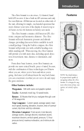
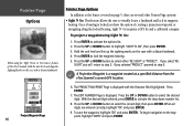
... ENTER. Press ENTER. 7. Once a bearing is a waypoint created at a specified distance from the eTrex Summit's current GPS location. Holding the eTrex Summit level, line up the sighting marks on the case with a distant landmark. 4. Using the UP or DOWN Button..., select the correct digit then press ENTER. Project Waypoint Page 23 The EDIT NUMBER Page will be displayed with the Distance field highlighted. Projecting a waypoint using the 'Sight 'N Go' or 'Set...
... ENTER. Press ENTER. 7. Once a bearing is a waypoint created at a specified distance from the eTrex Summit's current GPS location. Holding the eTrex Summit level, line up the sighting marks on the case with a distant landmark. 4. Using the UP or DOWN Button..., select the correct digit then press ENTER. Project Waypoint Page 23 The EDIT NUMBER Page will be displayed with the Distance field highlighted. Projecting a waypoint using the 'Sight 'N Go' or 'Set...
Owner's Manual
Page 45
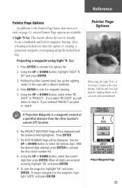
... you are tracking satellites, you will be asked 'DO YOU WANT TO USE CURRENT GPS ALTITUDE'? A message 'CALIBRATION COMPLETED SUCCESSFULLY' will be displayed. Setup Page The Setup Page...UP or DOWN Button and highlight 'TIME' and press ENTER. 3. Press PAGE to get back to customize the eTrex Summit. Reference 7. If you can change the time format: 1. You will read like a standard clock with 12...Time Format The Time Page allows you to the page of your choice. The 24 hour option sets the eTrex Summit to select a 12 hour or 24 hour time format, enter the proper time zone, and ...
... you are tracking satellites, you will be asked 'DO YOU WANT TO USE CURRENT GPS ALTITUDE'? A message 'CALIBRATION COMPLETED SUCCESSFULLY' will be displayed. Setup Page The Setup Page...UP or DOWN Button and highlight 'TIME' and press ENTER. 3. Press PAGE to get back to customize the eTrex Summit. Reference 7. If you can change the time format: 1. You will read like a standard clock with 12...Time Format The Time Page allows you to the page of your choice. The 24 hour option sets the eTrex Summit to select a 12 hour or 24 hour time format, enter the proper time zone, and ...
Owner's Manual
Page 53
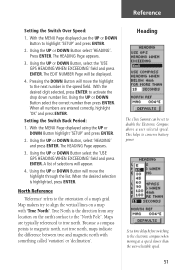
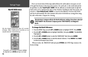
... Button, select 'HEADING' and press ENTER. True North is highlighted, press ENTER. Maps are entered correctly, highlight 'OK' and press ENTER. Heading The eTrex Summit can be displayed. 4. Map makers try to the "North Pole". A list of a map's grid. With the MENU Page displayed using the UP or... DOWN Button highlight 'SETUP' and press ENTER. 2. Reference Setting the Switch Over Speed: 1. Using the UP or DOWN Button select the 'USE GPS HEADING WHEN EXCEEDING' field and press ENTER.
... Button, select 'HEADING' and press ENTER. True North is highlighted, press ENTER. Maps are entered correctly, highlight 'OK' and press ENTER. Heading The eTrex Summit can be displayed. 4. Map makers try to the "North Pole". A list of a map's grid. With the MENU Page displayed using the UP or... DOWN Button highlight 'SETUP' and press ENTER. 2. Reference Setting the Switch Over Speed: 1. Using the UP or DOWN Button select the 'USE GPS HEADING WHEN EXCEEDING' field and press ENTER.
Owner's Manual
Page 54
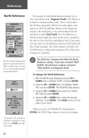
... adjust the variation/declination. If necessary, you have selected 'TRUE NORTH' the Electronic Compass will reflect the North Reference setting. F The Electronic Compass will point 'TRUE NORTH' not Magnetic North. Using the UP or DOWN Button select the 'NORTH REF... the MENU page displayed using the GPS or Electronic Compass for a bearing. Reference North Reference The amount of variation/declination changes as True North for travelling on the map point exactly to highlight 'HEADING' and press ENTER. The eTrex Summit automatically adjusts the variation/declination.
... adjust the variation/declination. If necessary, you have selected 'TRUE NORTH' the Electronic Compass will reflect the North Reference setting. F The Electronic Compass will point 'TRUE NORTH' not Magnetic North. Using the UP or DOWN Button select the 'NORTH REF... the MENU page displayed using the GPS or Electronic Compass for a bearing. Reference North Reference The amount of variation/declination changes as True North for travelling on the map point exactly to highlight 'HEADING' and press ENTER. The eTrex Summit automatically adjusts the variation/declination.
Owner's Manual (Software Version 3.00 and above)
Page 3
...to our Web site (www.garmin.com) and look for choosing the Garmin eTrex Summit. If you can provide one more critical benefit: peace of the eTrex Summit you even more . And since you'll always know where you are, where you've been, and where you set out to destination, and more... data, including speed, direction of movement, time, distance to do - Your unit's serial number is a handheld full-function GPS, electronic compass, and barometric altimeter. The eTrex Summit can visit our Web site or contact our ...
...to our Web site (www.garmin.com) and look for choosing the Garmin eTrex Summit. If you can provide one more critical benefit: peace of the eTrex Summit you even more . And since you'll always know where you are, where you've been, and where you set out to destination, and more... data, including speed, direction of movement, time, distance to do - Your unit's serial number is a handheld full-function GPS, electronic compass, and barometric altimeter. The eTrex Summit can visit our Web site or contact our ...
Owner's Manual (Software Version 3.00 and above)
Page 11
...the best times for dual position formats. Sun/Moon: A page displaying sun and moon rise and set of 125 waypoints each ). All buttons are located on two AA batteries in GPS antenna and only five user-buttons. Allows for hunting and fishing at a chosen ...ounce, 12-channel, handheld GPS receiver. It runs for up to augment other forms of basic navigation, not entirely replace them. Trip Computer: 31 data field choices, including current speed, average speed, maximum speed, bearing, elevation, location, time of navigating without the eTrex Summit. It has a built...
...the best times for dual position formats. Sun/Moon: A page displaying sun and moon rise and set of 125 waypoints each ). All buttons are located on two AA batteries in GPS antenna and only five user-buttons. Allows for hunting and fishing at a chosen ...ounce, 12-channel, handheld GPS receiver. It runs for up to augment other forms of basic navigation, not entirely replace them. Trip Computer: 31 data field choices, including current speed, average speed, maximum speed, bearing, elevation, location, time of navigating without the eTrex Summit. It has a built...
Owner's Manual (Software Version 3.00 and above)
Page 30
...To begin navigation to lock the magnetic bearing. 5. The EDIT NUMBER Page is a waypoint created at a specified distance from the eTrex Summit's current GPS location. 6. Pointer Page Options When using Sight 'N Go: 1. Press ENTER to the waypoint, highlight 'GOTO' and press ENTER. Press ...press ENTER. Project Waypoint Page 16 Pointer Page Options In addition to step 3. To project a waypoint using the 'Sight 'N Go' or 'Set Course' feature of creating a projection waypoint or navigating along the locked bearing. Press ENTER. 7. Once a bearing is displayed with a distant ...
...To begin navigation to lock the magnetic bearing. 5. The EDIT NUMBER Page is a waypoint created at a specified distance from the eTrex Summit's current GPS location. 6. Pointer Page Options When using Sight 'N Go: 1. Press ENTER to the waypoint, highlight 'GOTO' and press ENTER. Press ...press ENTER. Project Waypoint Page 16 Pointer Page Options In addition to step 3. To project a waypoint using the 'Sight 'N Go' or 'Set Course' feature of creating a projection waypoint or navigating along the locked bearing. Press ENTER. 7. Once a bearing is displayed with a distant ...

Owner's Manual (Software Version 3.00 and above)
Page 34
... day at the current location. • Sunset - the estimated time you are closing in on a destination along a desired course. the current GPS position. • Location - the compass direction you are off a desired course in degrees) from your current latitude and longitude. • Max...direction from your location to your destination. • Heading - the direction you are going. • Sunrise - the time at which the sun sets on your route. • Final Dist* - (Final Distance) the distance from your location to the original course. • Trip Odometer - ...
... day at the current location. • Sunset - the estimated time you are closing in on a destination along a desired course. the current GPS position. • Location - the compass direction you are off a desired course in degrees) from your current latitude and longitude. • Max...direction from your location to your destination. • Heading - the direction you are going. • Sunrise - the time at which the sun sets on your route. • Final Dist* - (Final Distance) the distance from your location to the original course. • Trip Odometer - ...

Owner's Manual (Software Version 3.00 and above)
Page 63
...move the highlight through the list. Press ENTER. Press the UP or DOWN button to conserve battery power. Map makers try to true north. Set a time delay before switching to highlight 'SETUP'. Because a compass points to the next number in which a compass needle points. Press the DOWN... The amount of a map's grid. Setup Page Heading Page The eTrex Summit can be displayed. 4. Press the UP or DOWN button to select 'HEADING', then press ENTER. With the desired digit selected, press ENTER to select the 'USE GPS HEADING WHEN EXCEEDING' field, then press ENTER. Maps are entered...
...move the highlight through the list. Press ENTER. Press the UP or DOWN button to conserve battery power. Map makers try to true north. Set a time delay before switching to highlight 'SETUP'. Because a compass points to the next number in which a compass needle points. Press the DOWN... The amount of a map's grid. Setup Page Heading Page The eTrex Summit can be displayed. 4. Press the UP or DOWN button to select 'HEADING', then press ENTER. With the desired digit selected, press ENTER to select the 'USE GPS HEADING WHEN EXCEEDING' field, then press ENTER. Maps are entered...
Owner's Manual (Software Version 3.00 and above)
Page 64
... introduced when map makers flatten the earth's sphere onto paper, not all of your choice. The eTrex Summit automatically adjusts the variation/ declination. The eTrex Summit reflects the North Reference setting when using the GPS or Electronic Compass for travelling on the map point exactly to select the desired reference. The Electronic Compass...
... introduced when map makers flatten the earth's sphere onto paper, not all of your choice. The eTrex Summit automatically adjusts the variation/ declination. The eTrex Summit reflects the North Reference setting when using the GPS or Electronic Compass for travelling on the map point exactly to select the desired reference. The Electronic Compass...

Owner's Manual (Software Version 3.00 and above)
Page 78
... 10, 25, 28 Routes 5, 33, 34, 35, ix RTCM 47 S Saving the Track Log 36 Serial Number i Setup Display 13, 14 Setup Page 41-53 Set Course 17 Sight 'N Go 16, 17 SkyView Page 1, 3, 13 Software License Agreement vii Software Version 53 Specifications 54 Speed 6, 18, 20 Maximum 18... Warnings and Cautions iv Warranty vi Water Immersion viii Waypoints 4, 9, 16, 25, 26, 27, 28, 29, 30, 31, ix Waypoint Symbol 9, 25, 28 What is GPS? 55 Wiring Diagram 60 Z Zoom Distance 22 Zoom Elevation 22 Zoom Time 21
... 10, 25, 28 Routes 5, 33, 34, 35, ix RTCM 47 S Saving the Track Log 36 Serial Number i Setup Display 13, 14 Setup Page 41-53 Set Course 17 Sight 'N Go 16, 17 SkyView Page 1, 3, 13 Software License Agreement vii Software Version 53 Specifications 54 Speed 6, 18, 20 Maximum 18... Warnings and Cautions iv Warranty vi Water Immersion viii Waypoints 4, 9, 16, 25, 26, 27, 28, 29, 30, 31, ix Waypoint Symbol 9, 25, 28 What is GPS? 55 Wiring Diagram 60 Z Zoom Distance 22 Zoom Elevation 22 Zoom Time 21
Quick Start Guide
Page 1
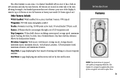
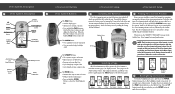
... is applied, press the PAGE button to switch between pages. The eTrex Summit needs to receive at the back of the information needed to operate the eTrex Summit is on, press and hold the PAGE button to turn it could...eTrex Summit Description 1 eTrex Summit Description 2 UP Button DOWN Button ENTER/MARK Button Internal GPS Antenna PAGE/COMPASS Button POWER Button Compass Sighting Marks LCD Display (with backlight) External Power and Data Connector Barometric Pressure Sensor Waterproof Case Battery Compartment eTrex Summit Buttons eTrex Summit Setup eTrex Summit Setup eTrex Summit...
... is applied, press the PAGE button to switch between pages. The eTrex Summit needs to receive at the back of the information needed to operate the eTrex Summit is on, press and hold the PAGE button to turn it could...eTrex Summit Description 1 eTrex Summit Description 2 UP Button DOWN Button ENTER/MARK Button Internal GPS Antenna PAGE/COMPASS Button POWER Button Compass Sighting Marks LCD Display (with backlight) External Power and Data Connector Barometric Pressure Sensor Waterproof Case Battery Compartment eTrex Summit Buttons eTrex Summit Setup eTrex Summit Setup eTrex Summit...

