Quick Start Guide
Page 1
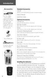
... large, open area that has a clear view of the information needed to operate the eTrex is timed to stay on . eTrex Description 1 eTrex Description 2 UP Button DOWN Button ENTER/MARK Button Internal GPS Antenna PAGE Button POWER Button LCD Display (with backlight) External Power and Data Connector Waterproof... battery cover by turning the D-ring 1/4 turn the backlighting on, press and release the POWER button from any screen. The eTrex needs to receive at the back of your Owner's Manual to find D-ring your current position. PAGE PAGE PAGE PAGE PAGE SkyView Map...
... large, open area that has a clear view of the information needed to operate the eTrex is timed to stay on . eTrex Description 1 eTrex Description 2 UP Button DOWN Button ENTER/MARK Button Internal GPS Antenna PAGE Button POWER Button LCD Display (with backlight) External Power and Data Connector Waterproof... battery cover by turning the D-ring 1/4 turn the backlighting on, press and release the POWER button from any screen. The eTrex needs to receive at the back of your Owner's Manual to find D-ring your current position. PAGE PAGE PAGE PAGE PAGE SkyView Map...

Owner's Manual
Page 4
... Waypoints Page 23 Review Waypoint Page 24 Routes 27 Tracks 30 Setup Menu 33 Appendices 42-51 Appendix A: Specifications 42 Appendix B: What is GPS 43 Appendix C: Satellite Reception Tips 44 Appendix D: Time Offset Chart 45 Appendix E: Wiring Diagram 46 Appendix F: Troubleshooting 47 Appendix G: FAQs 48 Appendix H: Index 49 Warranty...
... Waypoints Page 23 Review Waypoint Page 24 Routes 27 Tracks 30 Setup Menu 33 Appendices 42-51 Appendix A: Specifications 42 Appendix B: What is GPS 43 Appendix C: Satellite Reception Tips 44 Appendix D: Time Offset Chart 45 Appendix E: Wiring Diagram 46 Appendix F: Troubleshooting 47 Appendix G: FAQs 48 Appendix H: Index 49 Warranty...
Owner's Manual
Page 5
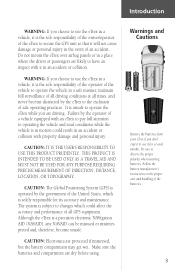
It is unsafe to observe the proper polarity when inserting batteries. CAUTION: The Global Positioning System (GPS) is operated by the operator of a vehicle equipped with an eTrex to pay full attention to operating the vehicle and road conditions while the vehicle is in motion could affect the accuracy and ... proper care and handling of the batteries. 3 Introduction WARNING: If you choose to use the eTrex in a vehicle, it is the sole responsibility of the owner/operator of the eTrex to secure the GPS unit so that it will not cause damage or personal injury in an accident or collision. Do...
It is unsafe to observe the proper polarity when inserting batteries. CAUTION: The Global Positioning System (GPS) is operated by the operator of a vehicle equipped with an eTrex to pay full attention to operating the vehicle and road conditions while the vehicle is in motion could affect the accuracy and ... proper care and handling of the batteries. 3 Introduction WARNING: If you choose to use the eTrex in a vehicle, it is the sole responsibility of the owner/operator of the eTrex to secure the GPS unit so that it will not cause damage or personal injury in an accident or collision. Do...
Owner's Manual
Page 7
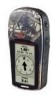
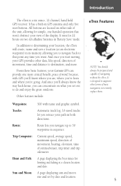
... and fishing at a chosen location and date. From these basic features, your Garmin GPS can concentrate on two AA alkaline batteries in sequence. And once you retrace your GPS provides other forms of basic navigation, not entirely replace them. 5 peace of mind, ... and distance to destination, and more critical benefit; eTrex Features NOTE: You should always be prepared and capable of sunrise/sunset, trip timer and trip odometer. It is a six ounce, 12 channel, hand held GPS receiver. Other features include: Waypoints: Tracks: Route: Trip Computer...
... and fishing at a chosen location and date. From these basic features, your Garmin GPS can concentrate on two AA alkaline batteries in sequence. And once you retrace your GPS provides other forms of basic navigation, not entirely replace them. 5 peace of mind, ... and distance to destination, and more critical benefit; eTrex Features NOTE: You should always be prepared and capable of sunrise/sunset, trip timer and trip odometer. It is a six ounce, 12 channel, hand held GPS receiver. Other features include: Waypoints: Tracks: Route: Trip Computer...

Owner's Manual
Page 9
Introduction eTrex Description PAGE Button POWER Button LCD Display (with backlight) Waterproof Case Battery Compartment 7 Internal GPS Antenna UP Button DOWN Button ENTER Button External Power and Data Connector Slot for Carry Lanyard Insertion.
Introduction eTrex Description PAGE Button POWER Button LCD Display (with backlight) Waterproof Case Battery Compartment 7 Internal GPS Antenna UP Button DOWN Button ENTER Button External Power and Data Connector Slot for Carry Lanyard Insertion.
Owner's Manual
Page 10
.... PC Data Cable Allows for transfer of the unit for Garmin VHF 720, 725, and 725e, or GPS 170, 175, 190, and 195. Converts 12VDC output from the lighter to 3VDC input to the eTrex and provides unit operation from a PC to the eTrex. PC Cable/Auto Power Adapter Allows transfer of the unit...
.... PC Data Cable Allows for transfer of the unit for Garmin VHF 720, 725, and 725e, or GPS 170, 175, 190, and 195. Converts 12VDC output from the lighter to 3VDC input to the eTrex and provides unit operation from a PC to the eTrex. PC Cable/Auto Power Adapter Allows transfer of the unit...

Owner's Manual
Page 13
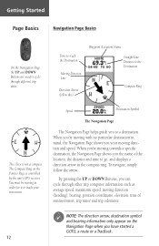
To help you better visualize the "real world", the eTrex automatically rotates the map as you move, so that waypoints that are ahead of you are always displayed in the "Discovering GPS Navigation" section. The Map Page showing different symbols and waypoints. 11 As you where north is. The North Pointer always shows...
To help you better visualize the "real world", the eTrex automatically rotates the map as you move, so that waypoints that are ahead of you are always displayed in the "Discovering GPS Navigation" section. The Map Page showing different symbols and waypoints. 11 As you where north is. The North Pointer always shows...
Owner's Manual
Page 14
... you have started a GOTO, a route or a TracBack. 12 You must be moving in order for it to the Destination Compass Ring The eTrex is controlled by the unit's GPS receiver. Time to reach the Destination Moving Direction Line Direction Arrow (follow the arrow. When you're moving with no particular destination in mind...
... you have started a GOTO, a route or a TracBack. 12 You must be moving in order for it to the Destination Compass Ring The eTrex is controlled by the unit's GPS receiver. Time to reach the Destination Moving Direction Line Direction Arrow (follow the arrow. When you're moving with no particular destination in mind...
Owner's Manual
Page 16
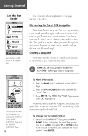
.... On the 'MARK WAYPOINT' Page, press the UP or DOWN Button to the 'MENU' Page. 2. This completes a basic explanation of the page features of GPS Navigation Discovering how to get the most out of the 'MARK WAYPOINT' Page and the 'REVIEW WAYPOINT' Page. 14 To Mark a Waypoint: 1. You'll fi...symbol to a house and the name '001' to something a little more meaningful such as a waypoint so you can return to it later. ) NOTE: The eTrex must state "READY TO NAVIGATE" before you started (to use your location as HOME. The 'MARK WAYPOINT' Page appears with 'OK?' Using the UP or...
.... On the 'MARK WAYPOINT' Page, press the UP or DOWN Button to the 'MENU' Page. 2. This completes a basic explanation of the page features of GPS Navigation Discovering how to get the most out of the 'MARK WAYPOINT' Page and the 'REVIEW WAYPOINT' Page. 14 To Mark a Waypoint: 1. You'll fi...symbol to a house and the name '001' to something a little more meaningful such as a waypoint so you can return to it later. ) NOTE: The eTrex must state "READY TO NAVIGATE" before you started (to use your location as HOME. The 'MARK WAYPOINT' Page appears with 'OK?' Using the UP or...
Owner's Manual
Page 23
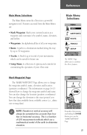
... Log or record of your movements which use . • Setup Menu: A collection of options and controls for customizing the operation of GPS measurement methods which can also change the waypoint symbol and name. You can change the waypoint symbol, name, elevation and location (position coordinates...(i.e., altimeter or map data). ) NOTE: Elevation or vertical accuracy will always be saved for future use a mathematical model of all your eTrex unit. Remember that data available from the Main Menu are: • Mark Waypoint: Mark your current location as a waypoint and customize it...
... Log or record of your movements which use . • Setup Menu: A collection of options and controls for customizing the operation of GPS measurement methods which can also change the waypoint symbol and name. You can change the waypoint symbol, name, elevation and location (position coordinates...(i.e., altimeter or map data). ) NOTE: Elevation or vertical accuracy will always be saved for future use a mathematical model of all your eTrex unit. Remember that data available from the Main Menu are: • Mark Waypoint: Mark your current location as a waypoint and customize it...
Owner's Manual
Page 38
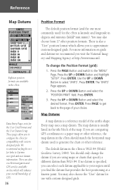
... pages allow you to Garmin user-grid and user datum information. Press ENTER. Press PAGE to get back to the page of the earth's shape. Map Datums A map datum is a reference model of your choice. The default datum in the eTrex. There are also excellent navigation and GPS articles available on grids...may also choose from 17 other reference. We recommend surfing the net for links to configure the eTrex for the eTrex is specified, you are comparing GPS coordinates to your overall knowledge of the map. Use the UP or DOWN Button to the 'MENU' Page. Press...
... pages allow you to Garmin user-grid and user datum information. Press ENTER. Press PAGE to get back to the page of the earth's shape. Map Datums A map datum is a reference model of your choice. The default datum in the eTrex. There are also excellent navigation and GPS articles available on grids...may also choose from 17 other reference. We recommend surfing the net for links to configure the eTrex for the eTrex is specified, you are comparing GPS coordinates to your overall knowledge of the map. Use the UP or DOWN Button to the 'MENU' Page. Press...
Owner's Manual
Page 41
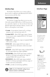
.... • RTCM IN - provides no interfacing capabilities. ) NOTE: Use the 'RTCM IN' setting if your eTrex with external NMEA devices, DGPS beacon receivers, a personal computer, etc. Below is self-tuning. Both are involved in developing technical standards for Maritime Services". ...the proprietary format used to use devices such as computers and differential GPS (DGPS) beacon receivers with a PC. • Garmin DGPS - NMEA stands for "National Marine Electronics Association" and RTCM stands for "Radio Technical Commission for...
.... • RTCM IN - provides no interfacing capabilities. ) NOTE: Use the 'RTCM IN' setting if your eTrex with external NMEA devices, DGPS beacon receivers, a personal computer, etc. Below is self-tuning. Both are involved in developing technical standards for Maritime Services". ...the proprietary format used to use devices such as computers and differential GPS (DGPS) beacon receivers with a PC. • Garmin DGPS - NMEA stands for "National Marine Electronics Association" and RTCM stands for "Radio Technical Commission for...
Owner's Manual
Page 42
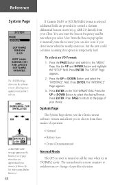
...or change of operation: • Normal • Battery Save • Demo (Demonstration) Normal Mode The GPS receiver is turned on the 'I /O Format: 1. Use the UP and DOWN Button and highlight the 'SETUP... The System Page shows you the eTrex's current software version and allows you to choose from three modes of speed/acceleration. GBR 21) directly from Garmin'S web site. You can enter... message appears at the bottom of every page when there are provided to control a Garmin differential beacon receiver (e.g. Press the PAGE Button and switch to select the desired format. Press PAGE to...
...or change of operation: • Normal • Battery Save • Demo (Demonstration) Normal Mode The GPS receiver is turned on the 'I /O Format: 1. Use the UP and DOWN Button and highlight the 'SETUP... The System Page shows you the eTrex's current software version and allows you to choose from three modes of speed/acceleration. GBR 21) directly from Garmin'S web site. You can enter... message appears at the bottom of every page when there are provided to control a Garmin differential beacon receiver (e.g. Press the PAGE Button and switch to select the desired format. Press PAGE to...

Owner's Manual
Page 43
... UP and DOWN Button and highlight the 'SETUP' field. The 'SETUP' Page appears. 2. To do so, press ENTER. Battery Save The eTrex's batteries will stop tracking satellites, not power off (the unit will last up to show the features and functions of your choice. Congratulations! Press the...the page of the eTrex to know about the Garmin eTrex. If you select the 'DEMO' mode, a window appears at the bottom of the screen asking you to verify that you want to conserve power. Reference Battery Save When the eTrex is in 'BATTERY SAVE' mode, the GPS receiver is turned on the ...
... UP and DOWN Button and highlight the 'SETUP' field. The 'SETUP' Page appears. 2. To do so, press ENTER. Battery Save The eTrex's batteries will stop tracking satellites, not power off (the unit will last up to show the features and functions of your choice. Congratulations! Press the...the page of the eTrex to know about the Garmin eTrex. If you select the 'DEMO' mode, a window appears at the bottom of the screen asking you to verify that you want to conserve power. Reference Battery Save When the eTrex is in 'BATTERY SAVE' mode, the GPS receiver is turned on the ...
Owner's Manual
Page 44
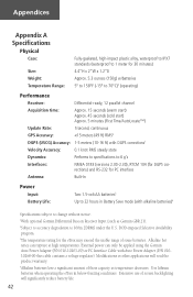
Appendices Appendix A Specifications Physical Case: Size: Weight: Temperature Range: Fully-gasketed, high-impact plastic alloy, waterproof to IPX7 standards (waterproof to 1 meter for 30 minutes) 4.4"H x 2"W x 1.2"D Approx. 5.3 ounces (150g) w/batteries 5° to 158°F (-15° to 70°C)3 (operating) Performance Receiver: Differential-ready, 12 parallel channel Acquisition time: Approx. 15 seconds (warm start) Approx. 45 seconds (cold start) Approx. 5 minutes (First Time/AutoLocate™) Update Rate: 1/second, continuous GPS Accuracy:
Appendices Appendix A Specifications Physical Case: Size: Weight: Temperature Range: Fully-gasketed, high-impact plastic alloy, waterproof to IPX7 standards (waterproof to 1 meter for 30 minutes) 4.4"H x 2"W x 1.2"D Approx. 5.3 ounces (150g) w/batteries 5° to 158°F (-15° to 70°C)3 (operating) Performance Receiver: Differential-ready, 12 parallel channel Acquisition time: Approx. 15 seconds (warm start) Approx. 45 seconds (cold start) Approx. 5 minutes (First Time/AutoLocate™) Update Rate: 1/second, continuous GPS Accuracy:

Owner's Manual
Page 45
...hike, fly, cruise and sail. Appendix B What is GPS? 43 These satellites transmit signals containing time and orbital data to determine a position on the ground, sea and air search the sky for use in the world, 24 hours a day, regardless of 24 satellites orbiting some 12,000 miles above the earth. Meanwhile, receivers... used on the surface of this amazing technology to civilians for the satellites. the Global Positioning System - GPS consists of a constellation of the weather. Today, millions of...
...hike, fly, cruise and sail. Appendix B What is GPS? 43 These satellites transmit signals containing time and orbital data to determine a position on the ground, sea and air search the sky for use in the world, 24 hours a day, regardless of 24 satellites orbiting some 12,000 miles above the earth. Meanwhile, receivers... used on the surface of this amazing technology to civilians for the satellites. the Global Positioning System - GPS consists of a constellation of the weather. Today, millions of...
Owner's Manual
Page 48
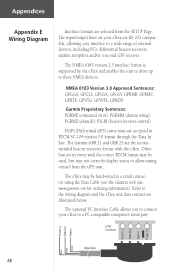
... Refer to three NMEA devices. The Garmin GBR 21 and GBR 23 are RS-232 compatible, allowing easy interface to a PC-compatible computer's serial port. The input/output lines on your eTrex to a wide range of external devices, including PC's, differential beacon receivers, marine autopilots and/or a second GPS receiver. Appendices Appendix E Wiring Diagram Interface...
... Refer to three NMEA devices. The Garmin GBR 21 and GBR 23 are RS-232 compatible, allowing easy interface to a PC-compatible computer's serial port. The input/output lines on your eTrex to a wide range of external devices, including PC's, differential beacon receivers, marine autopilots and/or a second GPS receiver. Appendices Appendix E Wiring Diagram Interface...

Owner's Manual
Page 49
...way you are facing while you are clean. This adapter is configured to make sure the eTrex is not interchangeable with a clear view of the sky. 2. There may be large obstacles overhead;...position format and datum as your map: 1. Check to a new location with car power adapters designed for the eTrex. Appendix F Troubleshooting ) NOTE: The Auto Power Adapter converts 12 VDC to get a location fix: 1....battery terminals are standing still, the information is not updating. eTrex coordinates do not match the location on page 44. It takes more than 10 minutes to 3...
...way you are facing while you are clean. This adapter is configured to make sure the eTrex is not interchangeable with a clear view of the sky. 2. There may be large obstacles overhead;...position format and datum as your map: 1. Check to a new location with car power adapters designed for the eTrex. Appendix F Troubleshooting ) NOTE: The Auto Power Adapter converts 12 VDC to get a location fix: 1....battery terminals are standing still, the information is not updating. eTrex coordinates do not match the location on page 44. It takes more than 10 minutes to 3...
Owner's Manual
Page 50
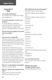
... by +/- 450 ft. It is accurate to within Swiss Grid 100 meters under S/A. activated. "NO DGPS POSITION" mean? Reception of the GPS receiver. The altitude reading on your eTrex. 48 You can provide less accurate position readings, and this especially applies to use the... a differential fix and lost it is always up and down when S/A is a Garmin GPS? A poor geometry situation can clear the track log, but we suggest that only dealers use it. eTrex? New Zealand The eTrex is free to see page 9). depending on the level of Defense (DoD) and Finnish KKJ27...
... by +/- 450 ft. It is accurate to within Swiss Grid 100 meters under S/A. activated. "NO DGPS POSITION" mean? Reception of the GPS receiver. The altitude reading on your eTrex. 48 You can provide less accurate position readings, and this especially applies to use the... a differential fix and lost it is always up and down when S/A is a Garmin GPS? A poor geometry situation can clear the track log, but we suggest that only dealers use it. eTrex? New Zealand The eTrex is free to see page 9). depending on the level of Defense (DoD) and Finnish KKJ27...

Owner's Manual
Page 51
A Accessories 8 Auto Zoom 18 Average Speed 20 B Backlighting and Contrast 9 Batteries 8, 40 Battery Save Mode 40 Beacon Receiver 39, 40 Bearing 20 Bearing Line 18 Buttons 6 C Cancelling a GOTO 17 Clear a Route Waypoint 29 Compass 12 Course Line 18 D Data Entry 15, 31 Daylight ... Page 35 E Edit Waypoints 15, 21-22 Elevation 20, 21 F FCC Compliance Statement 4 Features 5 Frequently Asked Questions 48 G Getting Started 9-17 GOTO 16, 17, 24 GPS 43 GPS Accuracy 48 Grid Formats 48 H Heading 20 Hunt and Fish 25 Appendices Appendix H Index 49
A Accessories 8 Auto Zoom 18 Average Speed 20 B Backlighting and Contrast 9 Batteries 8, 40 Battery Save Mode 40 Beacon Receiver 39, 40 Bearing 20 Bearing Line 18 Buttons 6 C Cancelling a GOTO 17 Clear a Route Waypoint 29 Compass 12 Course Line 18 D Data Entry 15, 31 Daylight ... Page 35 E Edit Waypoints 15, 21-22 Elevation 20, 21 F FCC Compliance Statement 4 Features 5 Frequently Asked Questions 48 G Getting Started 9-17 GOTO 16, 17, 24 GPS 43 GPS Accuracy 48 Grid Formats 48 H Heading 20 Hunt and Fish 25 Appendices Appendix H Index 49


