Quick Start Guide
Page 1
... satellite signals to turn clockwise. These pages are installed at the back of your location. PAGE PAGE PAGE PAGE PAGE SkyView Map Pointer Trip Computer Menu Welcome Page SkyView Page "Ready To Navigate" 6 Backlighting and Contrast To turn the unit on for 30 seconds to make the screen darker, press the DOWN button to save battery power. The backlight is found your location. NOTE: The first time you use your location...
... satellite signals to turn clockwise. These pages are installed at the back of your location. PAGE PAGE PAGE PAGE PAGE SkyView Map Pointer Trip Computer Menu Welcome Page SkyView Page "Ready To Navigate" 6 Backlighting and Contrast To turn the unit on for 30 seconds to make the screen darker, press the DOWN button to save battery power. The backlight is found your location. NOTE: The first time you use your location...
Quick Start Guide
Page 2
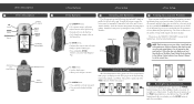
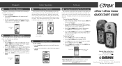
.... The Review Waypoint page for a few trips, the map display can clean up the screen by -Step Instructions to a waypoint using the Pointer Page. The TRACK LOG Page appears. 2. The track is pointing until the arrow points straight up , you to Get You Started (Turn this page and begin with Step 1) © 2004 Garmin Ltd. You are on the TRACKS Page. Press ENTER. 4. www.garmin.com eTrex / eTrex Camo QUICK START GUIDE Step-by clearing the track log...
.... The Review Waypoint page for a few trips, the map display can clean up the screen by -Step Instructions to a waypoint using the Pointer Page. The TRACK LOG Page appears. 2. The track is pointing until the arrow points straight up , you to Get You Started (Turn this page and begin with Step 1) © 2004 Garmin Ltd. You are on the TRACKS Page. Press ENTER. 4. www.garmin.com eTrex / eTrex Camo QUICK START GUIDE Step-by clearing the track log...
Owner's Manual
Page 3
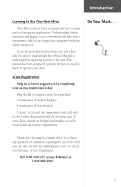
Understanding button operation and display screen conventions will take the time to read through this Owner's Manual to understand the operating features of the unit. On Your Mark. . . Why should you can begin basic navigation with just a little instruction. To get the most practical use from your new eTrex, take only a few minutes and you register your eTrex purchase? • Notification of Product Updates • Notifi...
Understanding button operation and display screen conventions will take the time to read through this Owner's Manual to understand the operating features of the unit. On Your Mark. . . Why should you can begin basic navigation with just a little instruction. To get the most practical use from your new eTrex, take only a few minutes and you register your eTrex purchase? • Notification of Product Updates • Notifi...
Owner's Manual
Page 7
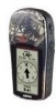
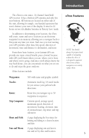
... and set out to this point any time you are located on two AA alkaline batteries in GPS antenna and only five user-buttons. It is a six ounce, 12 channel, hand held GPS receiver. It runs for 22 hours on either side of the display. Introduction The eTrex is designed to augment other data, like speed, direction of basic navigation, not entirely replace them. 5 Other features include: Waypoints: Tracks: Route: Trip...
... and set out to this point any time you are located on two AA alkaline batteries in GPS antenna and only five user-buttons. It is a six ounce, 12 channel, hand held GPS receiver. It runs for 22 hours on either side of the display. Introduction The eTrex is designed to augment other data, like speed, direction of basic navigation, not entirely replace them. 5 Other features include: Waypoints: Tracks: Route: Trip...
Owner's Manual
Page 10
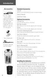
PC Data Cable Allows for creating waypoints and routes on a bicycle handle bar. MapSource® Map Data CD-ROMs An excellent tool for transfer of data from an automobile cigarette lighter. Insert the batteries observing proper polarity. Owner's Manual Quick Start Guide Optional Accessories Carrying Case Protects the eTrex when not in 'Battery Save' mode. PC Cable/Auto Power Adapter Allows transfer of the unit 1/4 turn clockwise. Not interchangeable with Auto Power Adapter 8 Standard Accessories Lanyard Attaches to...
PC Data Cable Allows for creating waypoints and routes on a bicycle handle bar. MapSource® Map Data CD-ROMs An excellent tool for transfer of data from an automobile cigarette lighter. Insert the batteries observing proper polarity. Owner's Manual Quick Start Guide Optional Accessories Carrying Case Protects the eTrex when not in 'Battery Save' mode. PC Cable/Auto Power Adapter Allows transfer of the unit 1/4 turn clockwise. Not interchangeable with Auto Power Adapter 8 Standard Accessories Lanyard Attaches to...
Owner's Manual
Page 11
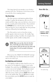
..., open area that has a clear view of the satellite signals, and the satellite tracking status. The eTrex needs to receive at least three strong satellite signals to make the screen lighter. When you can adjust the contrast or turn on the backlight. To adjust the screen contrast, press the PAGE Button until you to turn on the backlight. Press and hold the POWER Button to the basic operation of the eTrex's remaining features. The Satellite Page displays...
..., open area that has a clear view of the satellite signals, and the satellite tracking status. The eTrex needs to receive at least three strong satellite signals to make the screen lighter. When you can adjust the contrast or turn on the backlight. To adjust the screen contrast, press the PAGE Button until you to turn on the backlight. Press and hold the POWER Button to the basic operation of the eTrex's remaining features. The Satellite Page displays...
Owner's Manual
Page 12
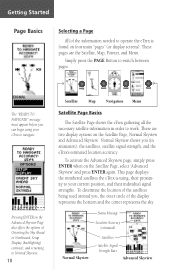
... Skyview Satellites Satellite Signal Strength Bars Advanced Skyview Simply press the PAGE Button to Normal Skyview. 10 PAGE PAGE PAGE PAGE Satellite Map Navigation Menu Satellite Page Basics The Satellite Page shows the eTrex gathering all the necessary satellite information in animation), the satellites, satellite signal strength, and the eTrex's estimated location accuracy. There are the Satellite, Map, Pointer, and Menu. These pages are two display options on the Satellite Page, select 'Advanced Skyview' and press ENTER again...
... Skyview Satellites Satellite Signal Strength Bars Advanced Skyview Simply press the PAGE Button to Normal Skyview. 10 PAGE PAGE PAGE PAGE Satellite Map Navigation Menu Satellite Page Basics The Satellite Page shows the eTrex gathering all the necessary satellite information in animation), the satellites, satellite signal strength, and the eTrex's estimated location accuracy. There are the Satellite, Map, Pointer, and Menu. These pages are two display options on the Satellite Page, select 'Advanced Skyview' and press ENTER again...
Owner's Manual
Page 14
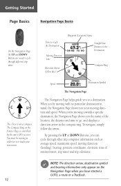
... a destination. You must be moving in mind, the Navigation Page shows you have started a GOTO, a route or a TracBack. 12 Getting Started Page Basics Navigation Page Basics On the Navigation Page, the UP and DOWN Buttons are used to cycle through other trip computer information such as average speed, maximum speed, moving direction (heading), bearing, position coordinates, elevation, time of the location, the distance and time to go, and displays a direction arrow in the compass ring.
... a destination. You must be moving in mind, the Navigation Page shows you have started a GOTO, a route or a TracBack. 12 Getting Started Page Basics Navigation Page Basics On the Navigation Page, the UP and DOWN Buttons are used to cycle through other trip computer information such as average speed, maximum speed, moving direction (heading), bearing, position coordinates, elevation, time of the location, the distance and time to go, and displays a direction arrow in the compass ring.
Owner's Manual
Page 17
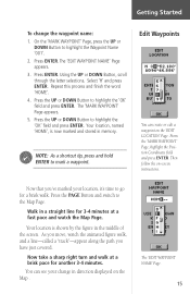
... Using the UP or DOWN Button, scroll through the letter selections. The 'MARK WAYPOINT' Page appears. 5. Now that you have just covered. Your location is now marked and stored in memory. ) NOTE: As a shortcut tip, press and hold ENTER to go for 3-4 minutes at a brisk pace for another 3-4 minutes. You can create or edit a waypoint on the 'EDIT LOCATION' Page. Getting Started To change in direction displayed on the Map...
... Using the UP or DOWN Button, scroll through the letter selections. The 'MARK WAYPOINT' Page appears. 5. Now that you have just covered. Your location is now marked and stored in memory. ) NOTE: As a shortcut tip, press and hold ENTER to go for 3-4 minutes at a brisk pace for another 3-4 minutes. You can create or edit a waypoint on the 'EDIT LOCATION' Page. Getting Started To change in direction displayed on the Map...
Owner's Manual
Page 18
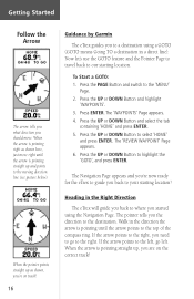
... ENTER. 5. Press the UP or DOWN Button to the 'MENU' Page. 2. Heading in the Right Direction The eTrex will guide you back to where you the direction to the destination. The pointer tells you started using a GOTO (GOTO means Going TO a destination in the direction the arrow is pointing straight up , you are on track! 16 Guidance by Garmin The eTrex guides you back to your starting location...
... ENTER. 5. Press the UP or DOWN Button to the 'MENU' Page. 2. Heading in the Right Direction The eTrex will guide you back to where you the direction to the destination. The pointer tells you started using a GOTO (GOTO means Going TO a destination in the direction the arrow is pointing straight up , you are on track! 16 Guidance by Garmin The eTrex guides you back to your starting location...
Owner's Manual
Page 20
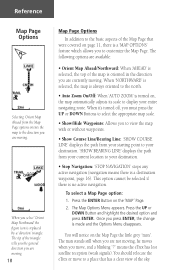
... Menu appears. means the eTrex has lost satellite reception (weak signals). Reference Map Page Options Selecting 'Orient Map Ahead' from your current location to your destination. • Stop Navigation: 'STOP NAVIGATION' stops any active navigation (navigation means there is a destination waypoint, page 16). When it's turned off, you must press the UP or DOWN Buttons to select the appropriate map scale. • Show/Hide Waypoints: Allows you to view the map with or without waypoints. • Show Course Line/Bearing...
... Menu appears. means the eTrex has lost satellite reception (weak signals). Reference Map Page Options Selecting 'Orient Map Ahead' from your current location to your destination. • Stop Navigation: 'STOP NAVIGATION' stops any active navigation (navigation means there is a destination waypoint, page 16). When it's turned off, you must press the UP or DOWN Buttons to select the appropriate map scale. • Show/Hide Waypoints: Allows you to view the map with or without waypoints. • Show Course Line/Bearing...

Owner's Manual
Page 22
Bearing-the compass direction between your current position coordinates. On the 'NAVIGATION' Page, press the UP or DOWN Button and scroll through the available options, stopping on the right track. Max Speed-the maximum speed traveled since last trip reset. Location-shows your location and destination. Average Speed-the average speed traveled since last reset. To change the fields at the bottom of the Navigation Page to display. 20 Sunset-the time of sunrise at...
Bearing-the compass direction between your current position coordinates. On the 'NAVIGATION' Page, press the UP or DOWN Button and scroll through the available options, stopping on the right track. Max Speed-the maximum speed traveled since last trip reset. Location-shows your location and destination. Average Speed-the average speed traveled since last reset. To change the fields at the bottom of the Navigation Page to display. 20 Sunset-the time of sunrise at...
Owner's Manual
Page 23
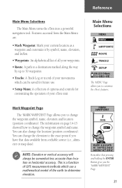
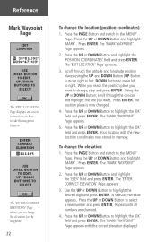
... for customizing the operation of the earth to the exact point if you have that pressing and holding the ENTER Button gives you the 'MARK WAYPOINT' Page. 21 You can be somewhat less accurate than location or horizontal accuracy. Mark Waypoint Page The 'MARK WAYPOINT' Page allows you to 50 waypoints. • Tracks: A Track Log or record of your eTrex unit. Reference Main Menu Selections The Main Menu turns the eTrex into a powerful navigation tool. Remember that data...
... for customizing the operation of the earth to the exact point if you have that pressing and holding the ENTER Button gives you the 'MARK WAYPOINT' Page. 21 You can be somewhat less accurate than location or horizontal accuracy. Mark Waypoint Page The 'MARK WAYPOINT' Page allows you to 50 waypoints. • Tracks: A Track Log or record of your eTrex unit. Reference Main Menu Selections The Main Menu turns the eTrex into a powerful navigation tool. Remember that data...
Owner's Manual
Page 24
Reference Mark Waypoint Page The 'EDIT LOCATION' Page displays on-screen instructions on how to right. Press the UP or DOWN Button and highlight the 'POSIITON COORDINATES' field and press ENTER. Scroll through the choices and highlight the one you want to change, stop and press ENTER. Your location with the correct elevation displayed. Press the UP or DOWN Button and highlight the 'ELEV' field and press ENTER. Press...
Reference Mark Waypoint Page The 'EDIT LOCATION' Page displays on-screen instructions on how to right. Press the UP or DOWN Button and highlight the 'POSIITON COORDINATES' field and press ENTER. Scroll through the choices and highlight the one you want to change, stop and press ENTER. Your location with the correct elevation displayed. Press the UP or DOWN Button and highlight the 'ELEV' field and press ENTER. Press...
Owner's Manual
Page 27
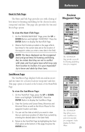
... responsibility to view the sun and moon position (if other than current) by highlighting the Hunt /Fish option at the bottom of best times for hunting and fishing for the chosen location (waypoint) and date. To view the Sun/Moon Page: 1. Press the ENTER Button to display the Hunt/Fish Page. 2. To view the Hunt /Fish Page: 1. On the 'REVIEW WAYPOINT' Page, press...
... responsibility to view the sun and moon position (if other than current) by highlighting the Hunt /Fish option at the bottom of best times for hunting and fishing for the chosen location (waypoint) and date. To view the Sun/Moon Page: 1. Press the ENTER Button to display the Hunt/Fish Page. 2. To view the Hunt /Fish Page: 1. On the 'REVIEW WAYPOINT' Page, press...

Owner's Manual
Page 33
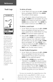
...-down alphanumeric list. 5. A default name will move the highlight to the next place in the 'SAVED TRACKS' list on a map. 3. The 'EDIT TRACK NAME' Page will be displayed. 4. The saved track will be displayed on the 'TRACK LOG' Page. ) NOTE: Saving a Track Log does not remove those points from a specific time or save a track for saving a track or 'ENTIRE LOG'. With the 'MENU' Page displayed, highlight 'TRACKS' and press ENTER. When the desired...
...-down alphanumeric list. 5. A default name will move the highlight to the next place in the 'SAVED TRACKS' list on a map. 3. The 'EDIT TRACK NAME' Page will be displayed. 4. The saved track will be displayed on the 'TRACK LOG' Page. ) NOTE: Saving a Track Log does not remove those points from a specific time or save a track for saving a track or 'ENTIRE LOG'. With the 'MENU' Page displayed, highlight 'TRACKS' and press ENTER. When the desired...
Owner's Manual
Page 34
... track (see sidebar). The 'BEGIN-END' pair imply the direction of the saved track. To delete a saved track: 1. Press ENTER. A confirmation window appears asking you if you want to travel. To start TracBack Navigation: 1. The 'NAVIGATION' Page guides you want to retrace the track, navigate to 'END'. Each saved track will always have a 'BEGIN' and 'END' point for navigation. If you want to track back to the starting point when saving a track...
... track (see sidebar). The 'BEGIN-END' pair imply the direction of the saved track. To delete a saved track: 1. Press ENTER. A confirmation window appears asking you if you want to travel. To start TracBack Navigation: 1. The 'NAVIGATION' Page guides you want to retrace the track, navigate to 'END'. Each saved track will always have a 'BEGIN' and 'END' point for navigation. If you want to track back to the starting point when saving a track...
Owner's Manual
Page 38
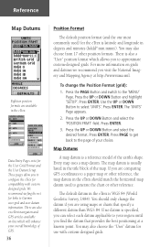
... get back to Garmin user-grid and user datum information. To change the datum if you are comparing GPS coordinates to approximate custom-designed grids. The default datum in the eTrex. Reference Map Datums Eighteen position formats are also excellent navigation and GPS articles available on grids and datums we recommend you visit the National Imagery and Mapping Agency at a known point. Data Entry Pages exist for the User Grid Format and the User Datum Setup. There is latitude...
... get back to Garmin user-grid and user datum information. To change the datum if you are comparing GPS coordinates to approximate custom-designed grids. The default datum in the eTrex. Reference Map Datums Eighteen position formats are also excellent navigation and GPS articles available on grids and datums we recommend you visit the National Imagery and Mapping Agency at a known point. Data Entry Pages exist for the User Grid Format and the User Datum Setup. There is latitude...
Owner's Manual
Page 48
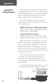
... ordering information). Refer to three NMEA devices. The optional PC Interface Cable allows you to connect your eTrex are RS-232 compatible, allowing easy interface to a wide range of external devices, including PC's, differential beacon receivers, marine autopilots and/or a second GPS receiver. NMEA 0183 Version 3.0 Approved Sentences: GPGGA, GPGLL, GPGSA, GPGSV, GPRMB, GPRMC, GPRTE, GPVTG, GPWPL, GPBOD Garmin Proprietary Sentences: PGRME (estimated error), PGRMM (datum...
... ordering information). Refer to three NMEA devices. The optional PC Interface Cable allows you to connect your eTrex are RS-232 compatible, allowing easy interface to a wide range of external devices, including PC's, differential beacon receivers, marine autopilots and/or a second GPS receiver. NMEA 0183 Version 3.0 Approved Sentences: GPGGA, GPGLL, GPGSA, GPGSV, GPRMB, GPRMC, GPRTE, GPVTG, GPWPL, GPBOD Garmin Proprietary Sentences: PGRME (estimated error), PGRMM (datum...
Owner's Manual
Page 50
... accuracy of User Defined Grid the GPS receiver is the geometry of the satellites in view of Defense (DoD) and Finnish KKJ27 Grid have the correct INPUT/ OUTPUT format selected on the level of GPS satellite signals is free to GPS altitude UTM/UPS (Universal Transfer Mercator/Universal Polar Stereographic) measurements. Why can clear the track log, but we suggest that you have been funded by U.S. eTrex? You can 't I turn...
... accuracy of User Defined Grid the GPS receiver is the geometry of the satellites in view of Defense (DoD) and Finnish KKJ27 Grid have the correct INPUT/ OUTPUT format selected on the level of GPS satellite signals is free to GPS altitude UTM/UPS (Universal Transfer Mercator/Universal Polar Stereographic) measurements. Why can clear the track log, but we suggest that you have been funded by U.S. eTrex? You can 't I turn...


