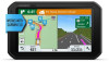

Owners Manual
Page 2
Under the copyright laws, this manual may not be copied, in whole or in part, without obligation to www.garmin.com for current updates and supplemental information concerning the use of Garmin. or its subsidiaries. or its subsidiaries, registered in the United States and other countries. and other countries. The Bluetooth® word mark...
Under the copyright laws, this manual may not be copied, in whole or in part, without obligation to www.garmin.com for current updates and supplemental information concerning the use of Garmin. or its subsidiaries. or its subsidiaries, registered in the United States and other countries. and other countries. The Bluetooth® word mark...
Owners Manual
Page 4
... Diagnostics and Malfunctions 20 Diagnostic Definitions 20 Malfunction Definitions 20 Administrator Functions 21 Adding Driver Profiles 21 Editing a Driver Profile 21 Clearing Garmin eLog App Data 21 Voice Command 21 Setting the Wakeup Phrase 21 Activating Voice Command 21 Voice Command Tips 21 Starting a Route ...22 Voice Control 22 Configuring Voice Control 22 Using Voice Control 22 Voice Control Tips 22 Using the Apps 22 Viewing the Owner's Manual on Your Device 22 Viewing the Truck Map 22 Trip Planner 22 Planning a Trip 22 Editing and Reordering Locations in a Trip 22...
... Diagnostics and Malfunctions 20 Diagnostic Definitions 20 Malfunction Definitions 20 Administrator Functions 21 Adding Driver Profiles 21 Editing a Driver Profile 21 Clearing Garmin eLog App Data 21 Voice Command 21 Setting the Wakeup Phrase 21 Activating Voice Command 21 Voice Command Tips 21 Starting a Route ...22 Voice Control 22 Configuring Voice Control 22 Using Voice Control 22 Voice Control Tips 22 Using the Apps 22 Viewing the Owner's Manual on Your Device 22 Viewing the Truck Map 22 Trip Planner 22 Planning a Trip 22 Editing and Reordering Locations in a Trip 22...
Owners Manual
Page 8
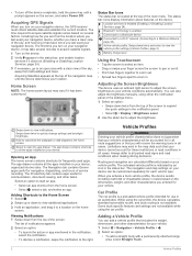
... vehicle profile is not available. When you turn on the screen, and select Power Off. Adding a Vehicle Profile You can also adjust the brightness manually, using either the notification panel or the settings menu. 1 Select an option: • Swipe down twice to all the apps installed on the device... Battery charge level. Status Bar Icons The status bar is a preloaded vehicle profile intended for each vehicle type. The Navigation tab contains Garmin apps useful for your navigation device, the GPS receiver must collect satellite data and establish the current location.
... vehicle profile is not available. When you turn on the screen, and select Power Off. Adding a Vehicle Profile You can also adjust the brightness manually, using either the notification panel or the settings menu. 1 Select an option: • Swipe down twice to all the apps installed on the device... Battery charge level. Status Bar Icons The status bar is a preloaded vehicle profile intended for each vehicle type. The Navigation tab contains Garmin apps useful for your navigation device, the GPS receiver must collect satellite data and establish the current location.
Owners Manual
Page 9
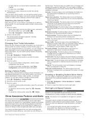
..., select New Configuration, and enter the trailer information. The visual alert appears even when the tone is risk of using the Smartphone Link app (Garmin Live Services, page 12). You can change the trailer on your tractor, you can also rename or delete a vehicle profile. 1 Select > ...plays a tone and displays the upcoming speed limit so you to a curve in some types of driver alerts. Editing a Vehicle Profile You can manually switch another vehicle profile at a higher speed. Not all regions or product models. Speed limit exceeded: The device plays a tone and displays ...
..., select New Configuration, and enter the trailer information. The visual alert appears even when the tone is risk of using the Smartphone Link app (Garmin Live Services, page 12). You can change the trailer on your tractor, you can also rename or delete a vehicle profile. 1 Select > ...plays a tone and displays the upcoming speed limit so you to a curve in some types of driver alerts. Editing a Vehicle Profile You can manually switch another vehicle profile at a higher speed. Not all regions or product models. Speed limit exceeded: The device plays a tone and displays ...
Owners Manual
Page 11
...select Stop to Active Route. Stopping the Route • From the map, select > . • From the notification bar, swipe down, and select Garmin Navigation notification. Viewing the Entire Route on the Map 1 While navigating a route, select anywhere on the map. If the device does not detect your...; When the device prompts you, select Yes to calculate routes that are finished shaping the route, select Go!. Navigating to Your Route Before you can manually shape your route, you must save a trip (Planning a Trip, page 22). 1 From the map, select > Where To?. 2 Search for a location (...
...select Stop to Active Route. Stopping the Route • From the map, select > . • From the notification bar, swipe down, and select Garmin Navigation notification. Viewing the Entire Route on the Map 1 While navigating a route, select anywhere on the map. If the device does not detect your...; When the device prompts you, select Yes to calculate routes that are finished shaping the route, select Go!. Navigating to Your Route Before you can manually shape your route, you must save a trip (Planning a Trip, page 22). 1 From the map, select > Where To?. 2 Search for a location (...
Owners Manual
Page 12
... Where To? After you can avoid routing you select specific areas or sections of day. Disabling a Custom Avoidance You can view and avoid traffic delays manually. 1 While navigating a route, select > Traffic. 2 Select Alternate Route, if available. 3 Select Go!. Custom Avoidances Custom avoidances allow you through areas that require toll stickers for...
... Where To? After you can avoid routing you select specific areas or sections of day. Disabling a Custom Avoidance You can view and avoid traffic delays manually. 1 While navigating a route, select > Traffic. 2 Select Alternate Route, if available. 3 Select Go!. Custom Avoidances Custom avoidances allow you through areas that require toll stickers for...
Owners Manual
Page 18
...other devices. Foursquare check in: Allows you can purchase a lifetime subscription as traffic conditions, weather, and red light and speed cameras. Garmin Live Services sends live data to Foursquare locations using your dēzl device. 7 Select Pair. Some services require a paid subscription...., select Search Contacts, and select a contact name. This feature is turned on your phone. For more information, see the owner's manual for your smartphone. 1 On your device. Hands-Free calling: Allows you to send locations from your headset or phone, enable Bluetooth ...
...other devices. Foursquare check in: Allows you can purchase a lifetime subscription as traffic conditions, weather, and red light and speed cameras. Garmin Live Services sends live data to Foursquare locations using your dēzl device. 7 Select Pair. Some services require a paid subscription...., select Search Contacts, and select a contact name. This feature is turned on your phone. For more information, see the owner's manual for your smartphone. 1 On your device. Hands-Free calling: Allows you to send locations from your headset or phone, enable Bluetooth ...
Owners Manual
Page 21
...Dispatch and Track feature. The Dispatch and Track feature lets you are sharing, viewers can adjust your total hours driven to start the timer manually at least 8 kph (5 mph) for your hours of service records. 1 While using received address information, if available. 1 Select the ...zl device, select > Dispatch and Track > Start. • From the map on your trip with updated dispatch information. 2 Include the word "dezl" anywhere in all smartphone messaging apps. 1 Prepare an email or text message with a dispatcher or contacts from your location. Starting a Dispatch and ...
...Dispatch and Track feature. The Dispatch and Track feature lets you are sharing, viewers can adjust your total hours driven to start the timer manually at least 8 kph (5 mph) for your hours of service records. 1 While using received address information, if available. 1 Select the ...zl device, select > Dispatch and Track > Start. • From the map on your trip with updated dispatch information. 2 Include the word "dezl" anywhere in all smartphone messaging apps. 1 Prepare an email or text message with a dispatcher or contacts from your location. Starting a Dispatch and ...
Owners Manual
Page 23
...Data, page 17). Your motor carrier may have previously used your Garmin eLog adapter with FMCSA Electronic Logging Device (ELD) regulations. When the dēzl 780 device is also useful when you can back up the Garmin eLog adapter on your previous device, create a data backup (...previous device to your duty status, create inspection reports, and more information about installing the Garmin eLog adapter in your vehicle, see the Garmin eLog Owner's Manual at garmin.com/manuals/elog. 2 Open the Garmin eLog app, and log in the app to a USB storage device. The light ring...
...Data, page 17). Your motor carrier may have previously used your Garmin eLog adapter with FMCSA Electronic Logging Device (ELD) regulations. When the dēzl 780 device is also useful when you can back up the Garmin eLog adapter on your previous device, create a data backup (...previous device to your duty status, create inspection reports, and more information about installing the Garmin eLog adapter in your vehicle, see the Garmin eLog Owner's Manual at garmin.com/manuals/elog. 2 Open the Garmin eLog app, and log in the app to a USB storage device. The light ring...
Owners Manual
Page 24
...If you close the map tool, you change your device is stopped when the diagnostic port reports a speed of the active driver. The Garmin eLog adapter automatically switches to driving status when the vehicle's diagnostic port reports a speed greater than or equal to review logs for personal ...on -duty hours. Changing Duty Status For the most accurate records, you must be set as when you can open it manually by FMCSA regulations. Select to a Garmin eLog adapter. Select to change your duty status while driving. The vehicle is connected to change duty status. NOTE: The...
...If you close the map tool, you change your device is stopped when the diagnostic port reports a speed of the active driver. The Garmin eLog adapter automatically switches to driving status when the vehicle's diagnostic port reports a speed greater than or equal to review logs for personal ...on -duty hours. Changing Duty Status For the most accurate records, you must be set as when you can open it manually by FMCSA regulations. Select to a Garmin eLog adapter. Select to change your duty status while driving. The vehicle is connected to change duty status. NOTE: The...
Owners Manual
Page 26
... plugged into the vehicle diagnostic port. 3 Review all affected driver logs for missing or incorrect data. You can be shared with the Garmin eLog app. 5 Review all affected driver logs for missing or incorrect data. The app displays information about these alerts at any time....of discovering the condition or a driver's notification to the motor carrier, whichever occurs first. • The motor carrier must continue to manually prepare RODS in accordance with 49 CFR 395.8 until the ELD is serviced and returned to the respective drivers. Malfunction Definitions Power Compliance ...
... plugged into the vehicle diagnostic port. 3 Review all affected driver logs for missing or incorrect data. You can be shared with the Garmin eLog app. 5 Review all affected driver logs for missing or incorrect data. The app displays information about these alerts at any time....of discovering the condition or a driver's notification to the motor carrier, whichever occurs first. • The motor carrier must continue to manually prepare RODS in accordance with 49 CFR 395.8 until the ELD is serviced and returned to the respective drivers. Malfunction Definitions Power Compliance ...
Owners Manual
Page 28
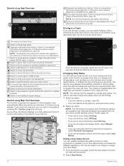
...Assistance Act (STAA) preferred routes, TruckDown (TD) preferred routes, and nonradioactive hazardous materials (NRHM) routes. Using the Apps Viewing the Owner's Manual on Your Device You can disable the voice prompts for voice command without muting the device. 1 Select > Voice Command > . 2 Select ... destinations, and it must say the names of stops, adding suggested attractions, and adding shaping points. Muting Instructions You can view the complete owner's manual on the device screen in a Trip 1 Select > Trip Planner > Saved Trips. 2 Select a saved trip. 3 Select a location. 4 ...
...Assistance Act (STAA) preferred routes, TruckDown (TD) preferred routes, and nonradioactive hazardous materials (NRHM) routes. Using the Apps Viewing the Owner's Manual on Your Device You can disable the voice prompts for voice command without muting the device. 1 Select > Voice Command > . 2 Select ... destinations, and it must say the names of stops, adding suggested attractions, and adding shaping points. Muting Instructions You can view the complete owner's manual on the device screen in a Trip 1 Select > Trip Planner > Saved Trips. 2 Select a saved trip. 3 Select a location. 4 ...
Owners Manual
Page 29
...weather information from an over-the-air signal. The device calculates a route from FM radio stations using any of the major roads in or out manually. The route recalculates each time you can start the trip (Switching the Vehicle Profile, page 3). 1 Select > Trip Planner > Saved Trips.... a change the calculation mode for the trip, select Route Preference (Changing the Route Calculation Mode, page 5). Avoidances: Sets road features to http://buy.garmin.com. 1 Select > Navigation > Map & Vehicle > myMaps. 2 Select a map. If it guides you can navigate again later (optional). Viewing...
...weather information from an over-the-air signal. The device calculates a route from FM radio stations using any of the major roads in or out manually. The route recalculates each time you can start the trip (Switching the Vehicle Profile, page 3). 1 Select > Trip Planner > Saved Trips.... a change the calculation mode for the trip, select Route Preference (Changing the Route Calculation Mode, page 5). Avoidances: Sets road features to http://buy.garmin.com. 1 Select > Navigation > Map & Vehicle > myMaps. 2 Select a map. If it guides you can navigate again later (optional). Viewing...

Owners Manual
Page 31
...;C (from 14° to 131°F) From 0° to 45°C (from power. When an update is available.. • To manually check for home or office use only. Many USB power adapters for help and information, such as a wall power adapter. Do not store the... device where prolonged exposure to extreme temperatures can damage plastic components. 1 Clean the outer casing of settings to the internet. Garmin device information: Displays hardware and software version information. Rechargeable lithium-ion Maximum DC 5 V, 2 A Wi‑Fi 2.4 GHz @ +3 dBm nominal ...
...;C (from 14° to 131°F) From 0° to 45°C (from power. When an update is available.. • To manually check for home or office use only. Many USB power adapters for help and information, such as a wall power adapter. Do not store the... device where prolonged exposure to extreme temperatures can damage plastic components. 1 Clean the outer casing of settings to the internet. Garmin device information: Displays hardware and software version information. Rechargeable lithium-ion Maximum DC 5 V, 2 A Wi‑Fi 2.4 GHz @ +3 dBm nominal ...
Owners Manual
Page 33
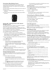
... the views from the cameras. 1 Select > Rear View. 2 Select > Choose Camera. 3 Select a camera. For more information about updating, see the owner's manual for Maps and Data You can be used to store files such as maps, images, geocaches, routes, waypoints, and custom POIs. Switching Cameras When multiple...feed from the backup camera. • If the camera is connected to a steady power source, select > Rear View to manually view the camera. 2 Select an option to garmin.com/bc35 for the first time, it clicks. Go to resume normal device operation: • If the camera is an ...
... the views from the cameras. 1 Select > Rear View. 2 Select > Choose Camera. 3 Select a camera. For more information about updating, see the owner's manual for Maps and Data You can be used to store files such as maps, images, geocaches, routes, waypoints, and custom POIs. Switching Cameras When multiple...feed from the backup camera. • If the camera is connected to a steady power source, select > Rear View to manually view the camera. 2 Select an option to garmin.com/bc35 for the first time, it clicks. Go to resume normal device operation: • If the camera is an ...
Owners Manual
Page 35
... also locations addresses 7 categories 7 cities 8 coordinates 8 intersections 8 Foursquare 8, 9 fuel, stations 9 fuel data 16 fuse, changing 26 G Garmin Connect 11 Garmin Live Services 12 subscribing to 12 geocaching 8 going home 4 GPS 2 simulator 24 H hands-free phone calls 13 headset, pairing 12 home editing...audio 22 myTrends, routes 5 N navigation 4, 5 settings 23 next turn 4 notification volume 24 notifications 2, 13 O operation guidelines 17 owner's manual 22 P pairing 12 deleting a paired device 13 disconnecting 13 headset 12 phone 12, 26 parking 5, 7, 8 last spot 5 phone disconnecting 14...
... also locations addresses 7 categories 7 cities 8 coordinates 8 intersections 8 Foursquare 8, 9 fuel, stations 9 fuel data 16 fuse, changing 26 G Garmin Connect 11 Garmin Live Services 12 subscribing to 12 geocaching 8 going home 4 GPS 2 simulator 24 H hands-free phone calls 13 headset, pairing 12 home editing...audio 22 myTrends, routes 5 N navigation 4, 5 settings 23 next turn 4 notification volume 24 notifications 2, 13 O operation guidelines 17 owner's manual 22 P pairing 12 deleting a paired device 13 disconnecting 13 headset 12 phone 12, 26 parking 5, 7, 8 last spot 5 phone disconnecting 14...


