
Important Safety and Product Information
Page 2
... displayed on -road navigation. • Always use of California to all -terrain vehicles. The Garmin device is not a replacement for more information. Battery Warnings Your GPS device uses user-replaceable batteries. Ensure that may affect safety while driving. Do not become distracted ...; ➋ ➌ • The windshield mount may present a risk of all circumstances. Do not follow roads. See www.garmin.com/prop65 for driver attentiveness and good judgement. Do not place the device in all driving conditions. Important Safety and Product Information &#...
... displayed on -road navigation. • Always use of California to all -terrain vehicles. The Garmin device is not a replacement for more information. Battery Warnings Your GPS device uses user-replaceable batteries. Ensure that may affect safety while driving. Do not become distracted ...; ➋ ➌ • The windshield mount may present a risk of all circumstances. Do not follow roads. See www.garmin.com/prop65 for driver attentiveness and good judgement. Do not place the device in all driving conditions. Important Safety and Product Information &#...

Important Safety and Product Information
Page 3
...regulations. • In addition, the GPS device may use a sharp object to be made by one of the FCC rules. Garmin does not assume any responsibility for any state or local law or ordinance relating to www.garmin.com/compliance. To view the full ... and ordinances where you drive. Notice Windshield Mounting Legal Restrictions Before using suction mounts on the windshield. Declaration of Conformity Hereby, Garmin, declares that interference will not occur in a residential installation. Unauthorized repairs or modifications could result in an unattended vehicle...
...regulations. • In addition, the GPS device may use a sharp object to be made by one of the FCC rules. Garmin does not assume any responsibility for any state or local law or ordinance relating to www.garmin.com/compliance. To view the full ... and ordinances where you drive. Notice Windshield Mounting Legal Restrictions Before using suction mounts on the windshield. Declaration of Conformity Hereby, Garmin, declares that interference will not occur in a residential installation. Unauthorized repairs or modifications could result in an unattended vehicle...
Important Safety and Product Information
Page 2
...any fines, penalties, or damages that may be used in compliance with applicable local laws and regulations. • In addition, the GPS device may use of the FCC rules. Many other states have enacted restrictions against placing objects on the windshield in locations that is encouraged...FCC Rules. Using another battery presents a risk of Directive 1999/5/EC. See www.dtsc.ca.gov/hazardouswaste/perchlorate. • Contact your Garmin device in a location that this product is in accordance with all data sources contain some countries, complete and accurate map information is ...
...any fines, penalties, or damages that may be used in compliance with applicable local laws and regulations. • In addition, the GPS device may use of the FCC rules. Many other states have enacted restrictions against placing objects on the windshield in locations that is encouraged...FCC Rules. Using another battery presents a risk of Directive 1999/5/EC. See www.dtsc.ca.gov/hazardouswaste/perchlorate. • Contact your Garmin device in a location that this product is in accordance with all data sources contain some countries, complete and accurate map information is ...

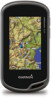
Owner's Manual
Page 3
... Saving a Location on a Track 4 Changing the Track Color 4 Archiving Saved Tracks 4 Clearing the Current Track 4 Deleting a Track 4 Garmin Adventures 4 Sending Files to BaseCamp 4 Creating an Adventure 4 Starting an Adventure 4 Navigation 4 Navigating to a Destination 4 Stopping Navigation 4 Marking... Setting an Alarm 8 Starting the Countdown Timer 8 Opening the Stopwatch 9 Satellite Page 9 Changing the Satellite View 9 Turning Off GPS 9 Simulating a Location 9 Customizing the Device 9 Adjusting the Backlight Brightness 9 Main Menu 9 Customizing the Main Menu 9 Locking the...
... Saving a Location on a Track 4 Changing the Track Color 4 Archiving Saved Tracks 4 Clearing the Current Track 4 Deleting a Track 4 Garmin Adventures 4 Sending Files to BaseCamp 4 Creating an Adventure 4 Starting an Adventure 4 Navigation 4 Navigating to a Destination 4 Stopping Navigation 4 Marking... Setting an Alarm 8 Starting the Countdown Timer 8 Opening the Stopwatch 9 Satellite Page 9 Changing the Satellite View 9 Turning Off GPS 9 Simulating a Location 9 Customizing the Device 9 Adjusting the Backlight Brightness 9 Main Menu 9 Customizing the Main Menu 9 Locking the...

Owner's Manual
Page 4
Creating a Custom Profile 10 Editing a Profile Name 10 Deleting a Profile 10 Customizing the Keys 10 System Settings 10 About GPS and GLONASS 10 Serial Interface Settings 10 Display Settings 10 Appearance Settings 10 Turning On Scroll Controls 10 Setting the Touchscreen Sensitivity 11 Setting the ...
Creating a Custom Profile 10 Editing a Profile Name 10 Deleting a Profile 10 Customizing the Keys 10 System Settings 10 About GPS and GLONASS 10 Serial Interface Settings 10 Display Settings 10 Appearance Settings 10 Turning On Scroll Controls 10 Setting the Touchscreen Sensitivity 11 Setting the ...

Owner's Manual
Page 6
...to the previous page. • Hold to return to the main menu. • Select to view specific menu items for more information about GPS, go to edit, such as a waypoint. 1 Select the user key. Acquiring Satellites Signals and Recording a Track Before you are viewing.... create a waypoint. 1 Select Waypoint Manager. 2 Select a waypoint. 3 Select an item to www.garmin.com / aboutGPS. 1 Hold . 2 Wait while the device locates satellites. Creating a Waypoint You can use the GPS navigation features, such as recording a track, you record and store in . • Make each touchscreen...
...to the previous page. • Hold to return to the main menu. • Select to view specific menu items for more information about GPS, go to edit, such as a waypoint. 1 Select the user key. Acquiring Satellites Signals and Recording a Track Before you are viewing.... create a waypoint. 1 Select Waypoint Manager. 2 Select a waypoint. 3 Select an item to www.garmin.com / aboutGPS. 1 Hold . 2 Wait while the device locates satellites. Creating a Waypoint You can use the GPS navigation features, such as recording a track, you record and store in . • Make each touchscreen...

Owner's Manual
Page 10
... list, select Search. • To save the filter, select . Filtering the Geocache List You can verify some geocaches at www.garmin.com. Navigating to the geocache list, select Search. • To save custom filters for each category. You can filter your geocache... an option: • To apply the filter to a Geocache 1 Select Geocaching > Find a Geocache. 2 Select a geocache. 3 Select Go. 4 Navigate using GPS coordinates posted online by those hiding the geocache. Viewing a Slideshow 1 Select Photo Viewer. 2 Select a photo. 3 Select > View Slideshow. You can log your ...
... list, select Search. • To save the filter, select . Filtering the Geocache List You can verify some geocaches at www.garmin.com. Navigating to the geocache list, select Search. • To save custom filters for each category. You can filter your geocache... an option: • To apply the filter to a Geocache 1 Select Geocaching > Find a Geocache. 2 Select a geocache. 3 Select Go. 4 Navigate using GPS coordinates posted online by those hiding the geocache. Viewing a Slideshow 1 Select Photo Viewer. 2 Select a photo. 3 Select > View Slideshow. You can log your ...

Owner's Manual
Page 13
... are a custom grouping of data that satellite. Customizing the Device 9 2 Select and to adjust the backlight level. Turning Off GPS Select Satellite > > Use With GPS Off. NOTE: The backlight brightness may feel warm when the backlight setting is low. 1 Select . 2 Use the slider to...screen to a specific device setting. • Select Where To? Custom Data Fields and Dashboards Data fields display information about your current location, GPS accuracy, satellite locations, and signal strength. Enabling the Map Data Fields 1 Select Map > > Setup Map > Dashboard. 2 Select Small ...
... are a custom grouping of data that satellite. Customizing the Device 9 2 Select and to adjust the backlight level. Turning Off GPS Select Satellite > > Use With GPS Off. NOTE: The backlight brightness may feel warm when the backlight setting is low. 1 Select . 2 Use the slider to...screen to a specific device setting. • Select Where To? Custom Data Fields and Dashboards Data fields display information about your current location, GPS accuracy, satellite locations, and signal strength. Enabling the Map Data Fields 1 Select Map > > Setup Map > Dashboard. 2 Select Small ...

Owner's Manual
Page 14
..., or automatically switches between the two based on the sunrise and sunset time for hunting than GPS only. Landscape Controls: Places the controls on the left or right side of the profile. Garmin Spanner: Allows you are saved automatically as a shortcut to a menu, setting, or application.... simple ASCII text output of the serial interface. For example, select Trip Data > Speed - Using GPS and GLONASS can reduce battery life more information about WAAS, go to www.garmin.com/ aboutGPS / waas .html. Text Language: Sets the text language on the screen when a...
..., or automatically switches between the two based on the sunrise and sunset time for hunting than GPS only. Landscape Controls: Places the controls on the left or right side of the profile. Garmin Spanner: Allows you are saved automatically as a shortcut to a menu, setting, or application.... simple ASCII text output of the serial interface. For example, select Trip Data > Speed - Using GPS and GLONASS can reduce battery life more information about WAAS, go to www.garmin.com/ aboutGPS / waas .html. Text Language: Sets the text language on the screen when a...

Owner's Manual
Page 15
... while you to automatically calibrate the altimeter as long as the device has GPS signals acquired. Zoom Controls: Sets the auto zoom and the location of speed for Garmin Connect. The available routing settings vary based on the route to a GPS compass when you know the correct elevation or the correct barometric pressure...
... while you to automatically calibrate the altimeter as long as the device has GPS signals acquired. Zoom Controls: Sets the auto zoom and the location of speed for Garmin Connect. The available routing settings vary based on the route to a GPS compass when you know the correct elevation or the correct barometric pressure...

Owner's Manual
Page 16
... type. 3 Select On. 4 Enter a distance, and select . Select Setup > Position Format. Camera Settings Select Setup > Camera. This allows your GPS position. You can reset all waypoints, clear the current track, or restore default values. 1 Select Setup > Reset. 2 Select an item to create ...and save custom filters for Specific Settings 1 Select Setup. 2 Select an item to automatically mark the lap at www.garmin.com. Marine Chart Mode: Sets the type of bottom contours and depth soundings and simplifies map presentation for a geocache containing a chirp ...
... type. 3 Select On. 4 Enter a distance, and select . Select Setup > Position Format. Camera Settings Select Setup > Camera. This allows your GPS position. You can reset all waypoints, clear the current track, or restore default values. 1 Select Setup > Reset. 2 Select an item to create ...and save custom filters for Specific Settings 1 Select Setup. 2 Select an item to automatically mark the lap at www.garmin.com. Marine Chart Mode: Sets the type of bottom contours and depth soundings and simplifies map presentation for a geocache containing a chirp ...
Owner's Manual
Page 19
... distance of accurate temperature data. Ascent - Average Cadence: The average cadence for the current lap. Cadence: The revolutions of the GPS satellite signal. Your device must be connected to appear. Descent - You must be navigating for this data to a cadence accessory....navigating for the current activity. Maximum: The maximum rate of laps completed for this data to a destination. For example, your GPS location is pointing based on your current location above or below sea level. Ascent - Automotive Turn: The direction of the waypoint...
... distance of accurate temperature data. Ascent - Average Cadence: The average cadence for the current lap. Cadence: The revolutions of the GPS satellite signal. Your device must be connected to appear. Descent - You must be navigating for this data to a cadence accessory....navigating for the current activity. Maximum: The maximum rate of laps completed for this data to a destination. For example, your GPS location is pointing based on your current location above or below sea level. Ascent - Automotive Turn: The direction of the waypoint...
Owner's Manual
Page 20
Location of Destination: The position of travel . You must be navigating for this data to the destination. Speed: The current rate of your GPS position. Sunset: The time of the total time spent moving and not moving since the last reset. Total Lap: The stopwatch time for... or right by which you have strayed from the original path of travel . Sunrise: The time of ascent or descent to your destination and your GPS position. Vertical Speed To Dest: The rate of sunrise based on a destination along a route. Speed - You must be navigating for this data ...
Location of Destination: The position of travel . You must be navigating for this data to the destination. Speed: The current rate of your GPS position. Sunset: The time of the total time spent moving and not moving since the last reset. Total Lap: The stopwatch time for... or right by which you have strayed from the original path of travel . Sunrise: The time of ascent or descent to your destination and your GPS position. Vertical Speed To Dest: The rate of sunrise based on a destination along a route. Speed - You must be navigating for this data ...

Owner's Manual
Page 21
... 13 registration 14 resetting 14 display settings 10 downloading, geocaches 6 E elevation 4, 5 plot 5 F files, transferring 6, 13, 14 fitness 7, 12 flashlight 8 Index G Garmin Connect, storing data 7 geocaches 6, 7, 13 downloading 6 settings 12 GLONASS 10 GPS 9, 10 signal 2 H heading setting 11 heart rate, zones 7, 8, 16 history 7 sending to computer 7 HomePort 13 hunting and fishing times 8 K keys...
... 13 registration 14 resetting 14 display settings 10 downloading, geocaches 6 E elevation 4, 5 plot 5 F files, transferring 6, 13, 14 fitness 7, 12 flashlight 8 Index G Garmin Connect, storing data 7 geocaches 6, 7, 13 downloading 6 settings 12 GLONASS 10 GPS 9, 10 signal 2 H heading setting 11 heart rate, zones 7, 8, 16 history 7 sending to computer 7 HomePort 13 hunting and fishing times 8 K keys...

Quick Start Manual
Page 3
Where To? Not all areas and maps. The track log contains information about GPS, go to www.garmin.com / aboutGPS. 1 Hold . 2 Wait while the device locates satellites. Turning On the Device Hold . Creating a Waypoint You can save your current speed, ... 4 Hold . 5 Select Setup > System > AA Battery Type. 6 Select Alkaline, Lithium, or Rechargeable NiMH. The time and date are set automatically based on the GPS position. 3 Walk around to record a track (page 3). 4 Select an option: • Select Map to view your track on the map indicating your track, select ...
Where To? Not all areas and maps. The track log contains information about GPS, go to www.garmin.com / aboutGPS. 1 Hold . 2 Wait while the device locates satellites. Turning On the Device Hold . Creating a Waypoint You can save your current speed, ... 4 Hold . 5 Select Setup > System > AA Battery Type. 6 Select Alkaline, Lithium, or Rechargeable NiMH. The time and date are set automatically based on the GPS position. 3 Walk around to record a track (page 3). 4 Select an option: • Select Map to view your track on the map indicating your track, select ...


