Owner's Manual
Page 3
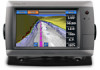
... Chart," you should touch Charts and then touch Navigation Chart. GPSMAP 700 Series Owner's Manual i Introduction Introduction WARNING See the Important Safety and Product Information guide in the product box for the following products: • GPSMAP® 720/720s • GPSMAP 740/740s • GPSMAP 750/750s Tips and Shortcuts • Select Home from any screen...
... Chart," you should touch Charts and then touch Navigation Chart. GPSMAP 700 Series Owner's Manual i Introduction Introduction WARNING See the Important Safety and Product Information guide in the product box for the following products: • GPSMAP® 720/720s • GPSMAP 740/740s • GPSMAP 750/750s Tips and Shortcuts • Select Home from any screen...
Owner's Manual
Page 7
... Where To?-provides navigation features (page 33). • Radar-sets up and shows radar (only available if the chartplotter is connected to a Garmin marine radar) (page 54). • Weather-(North America only) sets up a split screen displaying chart/chart, chart/sonar, chart/radar, ... deletes your built-in map supports Fishing charts. • Sonar-sets up and provides sonar information (only available with an "S" series unit, such as a GPSMAP 720s) (page 71). • Combinations-sets up and shows various weather parameters, including precipitation, forecast, fishing, sea conditions, and ...
... Where To?-provides navigation features (page 33). • Radar-sets up and shows radar (only available if the chartplotter is connected to a Garmin marine radar) (page 54). • Weather-(North America only) sets up a split screen displaying chart/chart, chart/sonar, chart/radar, ... deletes your built-in map supports Fishing charts. • Sonar-sets up and provides sonar information (only available with an "S" series unit, such as a GPSMAP 720s) (page 71). • Combinations-sets up and shows various weather parameters, including precipitation, forecast, fishing, sea conditions, and ...
Owner's Manual
Page 52
Device Configuration Units of Measure You can set the units of measure the chartplotter shows, using an "S" series chartplotter (such as a GPSMAP 720s) with a built-in each overlay. 48 GPSMAP 700 Series Owner's Manual Select Statute (mh, ft, ºF), Metric (kh, m, ºC), or Nautical (kt, ft, ºF). Complete an action: • Select Depth, and select Feet...
Device Configuration Units of Measure You can set the units of measure the chartplotter shows, using an "S" series chartplotter (such as a GPSMAP 720s) with a built-in each overlay. 48 GPSMAP 700 Series Owner's Manual Select Statute (mh, ft, ºF), Metric (kh, m, ºC), or Nautical (kt, ft, ºF). Complete an action: • Select Depth, and select Feet...
Owner's Manual
Page 75
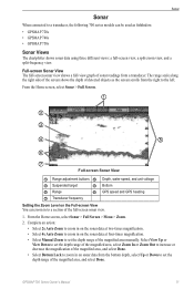
...to the left. The range scale along the right side of the screen shows the depth of detected objects as fishfinders: • GPSMAP 720s • GPSMAP 740s • GPSMAP 750s Sonar Views The chartplotter shows sonar data using three different views: a full-screen view, a split-zoom view, and a...in on the sonar data at four-times magnification. • Select Manual Zoom to set the depth range of the magnified area, and select Done. GPSMAP 700 Series Owner's Manual 71 From the Home screen, select Sonar > Full Screen. ➊ ➋ ➌ ➍ ➎ ➏ ➐...
...to the left. The range scale along the right side of the screen shows the depth of detected objects as fishfinders: • GPSMAP 720s • GPSMAP 740s • GPSMAP 750s Sonar Views The chartplotter shows sonar data using three different views: a full-screen view, a split-zoom view, and a...in on the sonar data at four-times magnification. • Select Manual Zoom to set the depth range of the magnified area, and select Done. GPSMAP 700 Series Owner's Manual 71 From the Home screen, select Sonar > Full Screen. ➊ ➋ ➌ ➍ ➎ ➏ ➐...


