Garmin GPSMAP 720s Support Question
Garmin GPSMAP 720s Support Question
Find answers below for this question about Garmin GPSMAP 720s.Need a Garmin GPSMAP 720s manual? We have 5 online manuals for this item!
Question posted by johela on May 1st, 2012
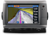
Power Connection Gpsmap 720s
Hi!
On the 19 pin connnector on a Garmin GPSMAP 720S, which pin is to be connected to + and which one to ground
John, Norway
Current Answers
Related Garmin GPSMAP 720s Manual Pages
Installation Instructions - Page 1
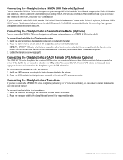
... 2000 network (page 6) • Connecting the chartplotter to a GA 30 remote GPS antenna (page 6). • Connecting the chartplotter to a Garmin marine radar (page 6). • Connecting the chartplotter to other important information.
Caution Always wear safety goggles, ear protection, and a dust mask when drilling, cutting, or sanding.
Go to power (page 5). 3. You can use the...
Installation Instructions - Page 2
... 3 to avoid any cracking in . (152-178 mm) of the template.
4. Apply marine sealant (optional).
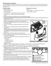
➊ GA 30 GPS antenna cable clip ➋ Power/data cable clip ➌ Garmin Marine Radar cable clip ➍ NMEA 2000 cable clip
Cable-Organization-Bracket Clip Identification
GPSMAP 700 Series Installation Instructions
Bail Mounting the Chartplotter Use the included bracket...
Installation Instructions - Page 4

... locking ring until after all the cables are not connecting the chartplotter to the battery, or if your warranty. Installing the Locking Ring
Wire Color
Wire Function
To the GPSMAP 700 series chartplotter
3FAuse
Red
Black
>
Blue
Brown
>
Gray
Violet
Power (10-32 Vdc) Ground
(power and NMEA 0183)
NMEA 0183 port 1 Tx (out)
NMEA...
Installation Instructions - Page 5
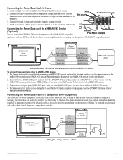
For Garmin devices, the ground (black) wires serve as NMEA 0183 ground and must be attached together or on the fuse block of your NMEA 0183 device. Connect the blue (NMEA 0183 port 1 out) wire from the GPSMAP 700 power/data cable to the NMEA 0183 in (or Rx/A +) wire from the NMEA 0183 device, and the...
Installation Instructions - Page 6
... to the instructions provided with the transducer. 2. Route the Garmin marine network cable to the chartplotter, and connect it to the chartplotter to provide GPS information. Route the GA 30 cable to the chartplotter, and connect it to the power/data cable.
GPSMAP 700 Series Installation Instructions Connecting the Chartplotter to a Transducer
If you are unfamiliar with the...
Installation Instructions - Page 7
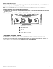
... Series Connectors
➊ NMEA 2000 connector ➋ Radar port ➌ Power/data connector ➍ External GPS antenna connector
Updating the Chartplotter Software
The GPSMAP 700 series chartplotter may damage the pins. 2. Note: You must install the locking rings before connecting the power/data cable or a Garmin radar cable to the chartplotter (page 4). After the cable is seated...
Installation Instructions - Page 8
...; 142 × 80 mm)
Weight
2.48 lb. (1.125 kg)
Display
W × H: 6 × 3 /19 32 in. (152 × 91 mm)
Case
Fully Gasketed, high-impact plastic and aluminum alloy, waterproof to 55°C)
Compass Safe 32 in. (813 mm) Distance
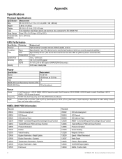
GPS Performance
Specification Parameter
Receiver
Acquisition Time
Warm Cold
Reacquisition
Update Rate
Accuracy...
Installation Instructions - Page 9
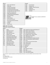
...Marine Electronics Association (NMEA) format and sentences from: NMEA Seven Riggs Avenue Severna Park, MD 21146 USA www.nmea.org
GPSMAP 700 Series Installation Instructions
Recommended Minimum Specific GNSS Data RTE - Routes VTG - Course Over Ground and Ground... Data AIS SAR Aircraft position report Radio Frequency/Mode/Power AIS Safety Related Broadcast Message DSC Call Information Wind...
Quick Reference Guide - Page 2

.... Navigating to a Marine Service
Navigating to www.garmin.com for minimum safe water depth and minimum safe obstacle height.
6.
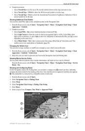
Garmin®, the Gamin logo, GPSMAP®, BlueChart®,...for the Navigation chart or the Fishing chart. Turning On the Chartplotter
Press and release the Power key.
From the Home screen, select Charts. 2. Select Navigation Chart or Fishing Chart.. 3....
Owner's Manual - Page 3

... Navigation Chart.
This manual includes information for product warnings and other important information. GPSMAP 700 Series Owner's Manual
i Manual Conventions
In this manual, when you are instructed...arrows (>) in the product box for the following products:
• GPSMAP® 720/720s • GPSMAP 740/740s • GPSMAP 750/750s
Tips and Shortcuts
• Select Home from any screen ...
Owner's Manual - Page 4

...the Chartplotter 1 Initial Chartplotter Settings 2 GPS Satellite Signal Acquisition 2 Adjusting the ...Mariner's Eye 3D 17 Fish Eye 3D 18 Fishing Chart 19 Showing Satellite Imagery on the
Navigation Chart 19... Garmin Autopilot 32
Where To 33 Marine ...GPS Satellite Locations 85 Using WAAS/EGNOS 85 System Information 85 NMEA 0183 and NMEA 2000 86 Registering Your Device 89 Contacting Garmin...
Owner's Manual - Page 5
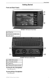
... Back Panels
Getting Started
Getting Started
➊ ➋
➌
GPSMAP 700 Series Front View ➊ Power key ➋ Automatic backlight sensor ➌ SD card slot
➊
➌
GPSMAP 700 Series Back View ➊ NMEA 2000 connector ➋ Power/data connector ➌ Radar Port ➍ External GPS antenna connector
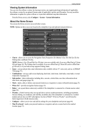
Turning On the Chartplotter
Press and release .
Owner's Manual - Page 7
... shows radar (only available if the chartplotter is connected to a Garmin marine radar) (page 54).
• Weather-(North ...connected devices.
• Charts-allows you use a BlueChart g2 Vision SD card or a BlueChart g2 SD card, or if your built-in map supports Fishing charts.
• Sonar-sets up and provides sonar information (only available with an "S" series unit, such as a GPSMAP 720s...
Owner's Manual - Page 9
... the Radar Overlay. From the Home screen, select Charts. 2. GPSMAP 700 Series Owner's Manual
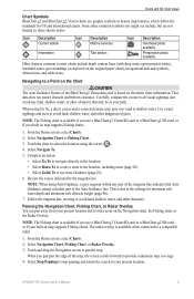
5 This is due to avoid land,... 6. Icon Description Current station
Information
Icon Description Marine services
Tide station
Icon Description
Overhead photo available
Perspective... the BlueChart g2 Vision data card is available when connected to avoid land, shallow water, and other dangerous ...
Owner's Manual - Page 15
...the sector in which a navigational light is connected to set the size of the boat. ...if the chartplotter is visible.
Showing Marine Service Points Service points indicate locations where marine maintenance and repair services may be obtained... rose (Compass, True Wind, or Apparent Wind).
➋
➊
GPSMAP 700 Series Owner's Manual
11 From the Home screen, select Charts > Navigation...
Owner's Manual - Page 16
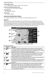
...connected to be tracked. A red X indicates that the AIS transmission from the vessel is
pointing indicates the direction in range.
The information reported for each vessel includes the Maritime Mobile Service Identity (MMSI), the location, the GPS speed, the GPS... the triangle is
lost , a message banner appears.
12
GPSMAP 700 Series Owner's Manual If the AIS transmission from the ...
Owner's Manual - Page 52
... overlay. Device Configuration
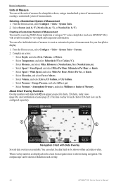
Units of Measure You can set the units of measure the chartplotter shows, using an "S" series chartplotter (such as a GPSMAP 720s) with a built-in each overlay.
48
GPSMAP 700 Series Owner's Manual Select Statute (mh, ft, ºF), Metric (kh, m, ºC), or Nautical (kt, ft, ºF). You can select the data...
Owner's Manual - Page 54
...Fishing Chart, Perspective 3D, or Mariner's Eye 3D. 3. From the Home screen, select Configure > System > GPS. 2. From the Home screen,...a BlueChart g2 SD card, or if your chartplotter must be connected to show and configure information about Your Boat
Calibrating a Water Speed..., contact Garmin Product Support.
50
GPSMAP 700 Series Owner's Manual If the wheel turns freely, check the cable...
Owner's Manual - Page 75

...Zoom.
2. Sonar
Sonar
When connected to a transducer, the ... depth range of detected objects as fishfinders: • GPSMAP 720s • GPSMAP 740s • GPSMAP 750s
Sonar Views
The chartplotter shows sonar data using three...voltage
➌ Suspended target
➍ Bottom
➎ Range
➏ GPS speed and GPS heading
➐ Transducer frequency
Setting the Zoom Level on sonar data ...
Owner's Manual - Page 95
...64 sonar 76 Garmin Product Support 89 ...33 GPS accuracy alarm 52 performance 84 signals 2 GPS ...power i range 15
L labeling engines and tanks 87 land-based POIs 11 lane width 16 language 2, 45 large-object interference 64 light sectors 11
M magnetic heading 8, 43, 67 magnetic variation 47 man overboard
creating from a navigation screen 27
creating from main menu 3 deleting 28 from VHF radio 80 Mariner...
Similar Questions

How Do I Go Into Simulation Mode On A Garmin Marine Gps Modle741xs
how do I use simulation mode on a garmin 741xs marine ver
how do I use simulation mode on a garmin 741xs marine ver
(Posted by Curthupp 6 years ago)
Garmin 720s Chartplotter
hi how do i enter long and lat on my chartplotter. thanks
hi how do i enter long and lat on my chartplotter. thanks
(Posted by franknuccio 9 years ago)

How To Reboot Inoperable Gpsmap 720?
My marine gpsmap 720 is inoperable. He is not getting beyond initial booting. I may have inserted a ...
My marine gpsmap 720 is inoperable. He is not getting beyond initial booting. I may have inserted a ...
(Posted by rdubbeldam 9 years ago)


541s Marine Gps. Depth Not Reading Out.
Depth has been working since installed. Now blank. Is there an on off control for this that may have...
Depth has been working since installed. Now blank. Is there an on off control for this that may have...
(Posted by therad50 11 years ago)