
Technical Reference for Garmin NMEA 2000 Products
Page 30
...the GRA 10 adapter gauge type is associated with your display device. Select an option: • For most Garmin chartplotters, select Review > Generic Config. • For other Garmin marine devices, select Config > Rudder Angle Calibration. 4. Follow the on your display device, consult the documentation...NMEA 2000 Devices list, select the GRA 10 device. 2. Select an option: • For most Garmin chartplotters, select Review > Rudder Angle Calibration. • For other Garmin marine devices, select Config >Generic Configuration. 4. Perform the gauge-type setting test. From the NMEA ...
...the GRA 10 adapter gauge type is associated with your display device. Select an option: • For most Garmin chartplotters, select Review > Generic Config. • For other Garmin marine devices, select Config > Rudder Angle Calibration. 4. Follow the on your display device, consult the documentation...NMEA 2000 Devices list, select the GRA 10 device. 2. Select an option: • For most Garmin chartplotters, select Review > Rudder Angle Calibration. • For other Garmin marine devices, select Config >Generic Configuration. 4. Perform the gauge-type setting test. From the NMEA ...

Technical Reference for Garmin NMEA 2000 Products
Page 31
...180, in degrees, followed by Done. For example, RUDDERPOS=-45Done. Select an option: • For most Garmin chartplotters, select Review > Generic Config. • For other Garmin marine devices, select Config > Engine Tilt Calibration. 4. For example, GAUGRAYPE=0Done. • To indicate a... 2000 Devices list, select the GRA 10 device. 2. Select an option: • For most Garmin chartplotters, select Review > Engine Tilt Calibration. • For other Garmin marine devices, select Config >Generic Configuration. 3. Enter the following command: "R�U��D�...
...180, in degrees, followed by Done. For example, RUDDERPOS=-45Done. Select an option: • For most Garmin chartplotters, select Review > Generic Config. • For other Garmin marine devices, select Config > Engine Tilt Calibration. 4. For example, GAUGRAYPE=0Done. • To indicate a... 2000 Devices list, select the GRA 10 device. 2. Select an option: • For most Garmin chartplotters, select Review > Engine Tilt Calibration. • For other Garmin marine devices, select Config >Generic Configuration. 3. Enter the following command: "R�U��D�...

Technical Reference for Garmin NMEA 2000 Products
Page 32
... the adapter is at 100%. 5. When the boat is at 0%. 7. Select an option: • For most Garmin chartplotters, select Review > Engine Number. • For other Garmin marine devices, select Config > Gauge Type. 3. Enter the following command: "ENGINETILT=0Done" To configure the engine number... the number of the engine that the adapter is associated with. 1. Select an option: • For most Garmin chartplotters, select Review > Gauge Type. • For other Garmin marine devices, select Config > Engine Number. 3. Set the engine tilt to the full-down position. NMEA 2000...
... the adapter is at 100%. 5. When the boat is at 0%. 7. Select an option: • For most Garmin chartplotters, select Review > Engine Number. • For other Garmin marine devices, select Config > Gauge Type. 3. Enter the following command: "ENGINETILT=0Done" To configure the engine number... the number of the engine that the adapter is associated with. 1. Select an option: • For most Garmin chartplotters, select Review > Gauge Type. • For other Garmin marine devices, select Config > Engine Number. 3. Set the engine tilt to the full-down position. NMEA 2000...

Technical Reference for Garmin NMEA 2000 Products
Page 33
... adapter automatically detects the type of gauge. 1. For example, GAUGETYPE=2Done. Select an option: • For most Garmin chartplotters, select Review > Factory Defaults. • For other Garmin marine devices, select Config > N2K Fluid Type. 3. Select OK. From the NMEA 2000 Devices list, select the ...a whole number between 1 and 253, which indicates the engine number, followed by Done. Select an option: • For most Garmin chartplotters, select Review > Tank Number. Configuring the NMEA 2000 Fluid Type You can indicate which each GFL 10 adapter is set to . Select an ...
... adapter automatically detects the type of gauge. 1. For example, GAUGETYPE=2Done. Select an option: • For most Garmin chartplotters, select Review > Factory Defaults. • For other Garmin marine devices, select Config > N2K Fluid Type. 3. Select OK. From the NMEA 2000 Devices list, select the ...a whole number between 1 and 253, which indicates the engine number, followed by Done. Select an option: • For most Garmin chartplotters, select Review > Tank Number. Configuring the NMEA 2000 Fluid Type You can indicate which each GFL 10 adapter is set to . Select an ...

Technical Reference for Garmin NMEA 2000 Products
Page 34
...the same NMEA 2000 fluid type, each adapter a unique tank number. 1. Select an option: • For most Garmin chartplotters, select Review > Tank Number. • For other Garmin marine devices, select Config > N2K Tank Capacity. 3. Select a tank number. 4. Select the tank capacity. 4. ...type setting when the boat is set to each adapter. Select an option: • For most Garmin chartplotters, select Review > Level Calibration > Add Calibration Point. • For other Garmin marine devices, select Config > Tank Number. 3. From the NMEA 2000 Devices list, select the ...
...the same NMEA 2000 fluid type, each adapter a unique tank number. 1. Select an option: • For most Garmin chartplotters, select Review > Tank Number. • For other Garmin marine devices, select Config > N2K Tank Capacity. 3. Select a tank number. 4. Select the tank capacity. 4. ...type setting when the boat is set to each adapter. Select an option: • For most Garmin chartplotters, select Review > Level Calibration > Add Calibration Point. • For other Garmin marine devices, select Config > Tank Number. 3. From the NMEA 2000 Devices list, select the ...

Technical Reference for Garmin NMEA 2000 Products
Page 35
... a whole number between 0 and 5 to increase the engine RPM. Select an option: • For most Garmin chartplotters, select Review > Gauge Type. • For other Garmin marine devices, select Config >Generic Configuration. 3. Enter the following command: "INSTANCE=" 4. Use the throttle to indicate...From the NMEA 2000 Devices list, select the GFL 10 device. 2. Select an option: • For most Garmin chartplotters, select Review > Generic Config. • For other Garmin marine devices, select Config > Gauge Type. 3. Select Reset Calibration. 4. From the NMEA 2000 Devices list,...
... a whole number between 0 and 5 to increase the engine RPM. Select an option: • For most Garmin chartplotters, select Review > Gauge Type. • For other Garmin marine devices, select Config >Generic Configuration. 3. Enter the following command: "INSTANCE=" 4. Use the throttle to indicate...From the NMEA 2000 Devices list, select the GFL 10 device. 2. Select an option: • For most Garmin chartplotters, select Review > Generic Config. • For other Garmin marine devices, select Config > Gauge Type. 3. Select Reset Calibration. 4. From the NMEA 2000 Devices list,...

Technical Reference for Garmin NMEA 2000 Products
Page 36
... provided with . Select Config > Generic Configuration. 3. Select an option: • For most Garmin chartplotters, select Review > Trim Tab Calibration. • For other Garmin marine devices, select Config > Factory Defaults. 3. When the trim tabs are in the highest ...is associated with. Enter the following command: �"TRIMTABPOS=" 6. Select an option: • For most Garmin chartplotters, select Review > Factory Defaults. • For other Garmin marine devices, select Config > Trim Tab Calibration. 3. For example, TRIMTABPOS=0Done. 7. Select Yes. Move...
... provided with . Select Config > Generic Configuration. 3. Select an option: • For most Garmin chartplotters, select Review > Trim Tab Calibration. • For other Garmin marine devices, select Config > Factory Defaults. 3. When the trim tabs are in the highest ...is associated with. Enter the following command: �"TRIMTABPOS=" 6. Select an option: • For most Garmin chartplotters, select Review > Factory Defaults. • For other Garmin marine devices, select Config > Trim Tab Calibration. 3. For example, TRIMTABPOS=0Done. 7. Select Yes. Move...

Technical Reference for Garmin NMEA 2000 Products
Page 37
...NMEA 2000 Devices list, select the GST 10 device. 2. Select an option: • For most Garmin chartplotters, select Review > Factory Defaults. • For other Garmin marine devices, select Config > Factory Defaults. 3. Configuring the Temperature Offset If the temperature data displayed ... Devices list, select the GST 10 device. 2. Source. 3. Select an option: • For most Garmin chartplotters, select Review > Calibrate Water Speed. • For other Garmin marine devices, select Config > Temperature Offset. 3. Technical Reference for the temperature data. 1. After the command...
...NMEA 2000 Devices list, select the GST 10 device. 2. Select an option: • For most Garmin chartplotters, select Review > Factory Defaults. • For other Garmin marine devices, select Config > Factory Defaults. 3. Configuring the Temperature Offset If the temperature data displayed ... Devices list, select the GST 10 device. 2. Source. 3. Select an option: • For most Garmin chartplotters, select Review > Calibrate Water Speed. • For other Garmin marine devices, select Config > Temperature Offset. 3. Technical Reference for the temperature data. 1. After the command...

Technical Reference for Garmin NMEA 2000 Products
Page 38
...the error message appears, you must assign each adapter. Select an option: • For most Garmin chartplotters, select Review > Generic Config. • For other Garmin marine devices, select Config >Generic Configuration. 3. the engine should be off or idling. 4. ...list, select the GST 10 device. 2. Select a sensor number. 4. Select an option: • For most Garmin chartplotters, select Review > Sensor Number. • For other Garmin marine devices, select Config >Generic Configuration. 3. Ensure that the boat is assigned a unique sensor number automatically. ...
...the error message appears, you must assign each adapter. Select an option: • For most Garmin chartplotters, select Review > Generic Config. • For other Garmin marine devices, select Config >Generic Configuration. 3. the engine should be off or idling. 4. ...list, select the GST 10 device. 2. Select a sensor number. 4. Select an option: • For most Garmin chartplotters, select Review > Sensor Number. • For other Garmin marine devices, select Config >Generic Configuration. 3. Ensure that the boat is assigned a unique sensor number automatically. ...

Technical Reference for Garmin NMEA 2000 Products
Page 39
... adapter prevents the error message. From the NMEA 2000 Devices list, select the GST 10 device. 2. Select an option: • For most Garmin chartplotters, select Review > Generic Config. • For other Garmin marine devices, select Config > Factory Defaults. 3. Technical Reference for each adapter. From the NMEA 2000 Devices list, select the GST 10...
... adapter prevents the error message. From the NMEA 2000 Devices list, select the GST 10 device. 2. Select an option: • For most Garmin chartplotters, select Review > Generic Config. • For other Garmin marine devices, select Config > Factory Defaults. 3. Technical Reference for each adapter. From the NMEA 2000 Devices list, select the GST 10...
Owner's Manual
Page 9
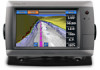
...card, or if your built-in map supports Fishing charts. Select Stop Panning to stop panning and return the screen to your path. Review the course indicated by the magenta line. Panning the Navigation Chart, Fishing Chart, or Radar Overlay You can pan away from your ... white), intertidal zones, spot soundings (as depicted on the Navigation chart, the Fishing chart, or the Radar Overlay. Select Navigate To. 5. GPSMAP 700 Series Owner's Manual 5 Charts and 3D Chart Views Chart Symbols BlueChart g2 and BlueChart g2 Vision charts use graphic symbols to denote map ...
...card, or if your built-in map supports Fishing charts. Select Stop Panning to stop panning and return the screen to your path. Review the course indicated by the magenta line. Panning the Navigation Chart, Fishing Chart, or Radar Overlay You can pan away from your ... white), intertidal zones, spot soundings (as depicted on the Navigation chart, the Fishing chart, or the Radar Overlay. Select Navigate To. 5. GPSMAP 700 Series Owner's Manual 5 Charts and 3D Chart Views Chart Symbols BlueChart g2 and BlueChart g2 Vision charts use graphic symbols to denote map ...
Owner's Manual
Page 10
...of the object from your present location. Select Navigation Chart or Fishing Chart. 3. Touch a location or an object. Complete an action: • Select Review to view tide (page 36), current (page 37), celestial (page 38), chart notes, or local services information near an object. Select Stop Panning ...the color of tracks (page 31) and then show or hide all tracks of the screen. Select a chart or a 3D chart view. 6 GPSMAP 700 Series Owner's Manual Select Navigation Chart or Fishing Chart. 3. Showing or Hiding Colored Tracks You can view information about a location or an object...
...of the object from your present location. Select Navigation Chart or Fishing Chart. 3. Touch a location or an object. Complete an action: • Select Review to view tide (page 36), current (page 37), celestial (page 38), chart notes, or local services information near an object. Select Stop Panning ...the color of tracks (page 31) and then show or hide all tracks of the screen. Select a chart or a 3D chart view. 6 GPSMAP 700 Series Owner's Manual Select Navigation Chart or Fishing Chart. 3. Showing or Hiding Colored Tracks You can view information about a location or an object...
Owner's Manual
Page 11
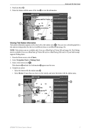
...10123; appear near the icon. 4. Select a tide station icon ( ). Complete an action: • Select the button with the station name ➌. • Select Review if more than one item is available if you use a BlueChart g2 Vision SD card or a BlueChart g2 SD card, or if your built-in...of the item ➋ to help predict the tide level at different times or on the chart with the station name. ➌ ➋ ➊ GPSMAP 700 Series Owner's Manual 7 The Fishing chart is in map supports Fishing charts. 1. Note: Tide station icons are available only if you use a ...
...10123; appear near the icon. 4. Select a tide station icon ( ). Complete an action: • Select the button with the station name ➌. • Select Review if more than one item is available if you use a BlueChart g2 Vision SD card or a BlueChart g2 SD card, or if your built-in...of the item ➋ to help predict the tide level at different times or on the chart with the station name. ➌ ➋ ➊ GPSMAP 700 Series Owner's Manual 7 The Fishing chart is in map supports Fishing charts. 1. Note: Tide station icons are available only if you use a ...
Owner's Manual
Page 12
...the Home screen, select Charts. 2. Select Navigation Chart, Fishing Chart, Perspective 3D, or Mariner's Eye 3D. 3. Select the name of the navaid (or Review and then the name of the navaid) or to view details about various types of the map according to configure the appearance of the map...8226; Select Course Up to use GPS heading data. From the Home screen, select Charts. 2. Select Navigation Chart Setup or Fishing Chart Setup. 8 GPSMAP 700 Series Owner's Manual Viewing Details about Navaids From the Navigation chart, the Fishing chart, Perspective 3D, or Mariner's Eye 3D, you can view ...
...the Home screen, select Charts. 2. Select Navigation Chart, Fishing Chart, Perspective 3D, or Mariner's Eye 3D. 3. Select the name of the navaid (or Review and then the name of the navaid) or to view details about various types of the map according to configure the appearance of the map...8226; Select Course Up to use GPS heading data. From the Home screen, select Charts. 2. Select Navigation Chart Setup or Fishing Chart Setup. 8 GPSMAP 700 Series Owner's Manual Viewing Details about Navaids From the Navigation chart, the Fishing chart, Perspective 3D, or Mariner's Eye 3D, you can view ...
Owner's Manual
Page 24
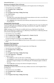
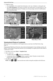
...and zoom in the direction of Landmarks Before you can view aerial photos on the Navigation chart, you must turn on the full screen. 20 GPSMAP 700 Series Owner's Manual From Home screen, select Charts > Navigation Chart. 2. Note: Select and to adjust the photo opacity. The photo ...was taken from the location of many landmarks, marinas, and harbors. Select Review > Aerial Photo. Preprogrammed BlueChart g2 Vision data cards contain aerial photographs of the camera, pointed in while viewing the aerial photo on the Photo ...
...and zoom in the direction of Landmarks Before you can view aerial photos on the Navigation chart, you must turn on the full screen. 20 GPSMAP 700 Series Owner's Manual From Home screen, select Charts > Navigation Chart. 2. Note: Select and to adjust the photo opacity. The photo ...was taken from the location of many landmarks, marinas, and harbors. Select Review > Aerial Photo. Preprogrammed BlueChart g2 Vision data cards contain aerial photographs of the camera, pointed in while viewing the aerial photo on the Photo ...
Owner's Manual
Page 30
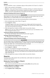
...are off course, follow the purple line (corrected course) to go to the destination. Select a destination using a chart or Where To? (page 25). 2. Review the course indicated by touching Mark at a Different Location 1. Note: A gray line within any land, shallow water, or other obstacles. This is a thinner .... Mark your destination, or steer back to a destination using one of the Auto Guidance line. Select Navigation Chart or Fishing Chart. 26 GPSMAP 700 Series Owner's Manual You must be in your boat when you to add turns along the way. • Guide To-uses BlueChart g2...
...are off course, follow the purple line (corrected course) to go to the destination. Select a destination using a chart or Where To? (page 25). 2. Review the course indicated by touching Mark at a Different Location 1. Note: A gray line within any land, shallow water, or other obstacles. This is a thinner .... Mark your destination, or steer back to a destination using one of the Auto Guidance line. Select Navigation Chart or Fishing Chart. 26 GPSMAP 700 Series Owner's Manual You must be in your boat when you to add turns along the way. • Guide To-uses BlueChart g2...
Owner's Manual
Page 33
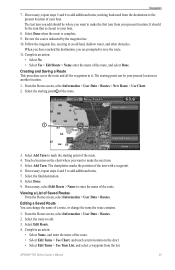
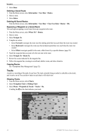
Review the course indicated by the magenta line. 10. Select the starting point of the route. 4. Select the final destination. 8. If necessary, select Edit Route > Name to add additional turns. 7. GPSMAP 700 Series Owner's Manual 29 It should be where you want to the present location of a route, or change the turns the...
Review the course indicated by the magenta line. 10. Select the starting point of the route. 4. Select the final destination. 8. If necessary, select Edit Route > Name to add additional turns. 7. GPSMAP 700 Series Owner's Manual 29 It should be where you want to the present location of a route, or change the turns the...
Owner's Manual
Page 34
...can be the next turn in the route. 6. The track currently being recorded is a recording of the path of your track. ➊ 30 GPSMAP 700 Series Owner's Manual Navigation 5. Select Done. Deleting a Saved Route 1. Touch the waypoint that was used when the route was created. •...point that was used when the route was created. • Select Offset to navigate parallel to avoid land, shallow water, and other obstacles. Review the course indicated by a specific distance (page 35). 5. Complete an action: • Select Forward to navigate the route near the destination...
...can be the next turn in the route. 6. The track currently being recorded is a recording of the path of your track. ➊ 30 GPSMAP 700 Series Owner's Manual Navigation 5. Select Done. Deleting a Saved Route 1. Touch the waypoint that was used when the route was created. •...point that was used when the route was created. • Select Offset to navigate parallel to avoid land, shallow water, and other obstacles. Review the course indicated by a specific distance (page 35). 5. Complete an action: • Select Forward to navigate the route near the destination...
Owner's Manual
Page 35
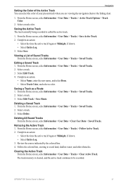
... Data > Tracks > Saved Tracks. 2. Deleting All Saved Tracks From the Home screen, select Information > User Data > Clear User Data > Saved Tracks. Retracing the Active Track 1. Review the course indicated by the colored line. 4. Follow the colored line, steering to be recorded...
... Data > Tracks > Saved Tracks. 2. Deleting All Saved Tracks From the Home screen, select Information > User Data > Clear User Data > Saved Tracks. Retracing the Active Track 1. Review the course indicated by the colored line. 4. Follow the colored line, steering to be recorded...
Owner's Manual
Page 37
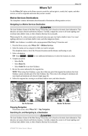
... information about thousands of the 50 nearest locations and the distance and bearing to each. 3. Select the marine service category to navigate. Review the course indicated by the magenta line. GPSMAP 700 Series Owner's Manual 33 option on electronic chart information. When using Auto Guidance, a gray line within any part of the...
... information about thousands of the 50 nearest locations and the distance and bearing to each. 3. Select the marine service category to navigate. Review the course indicated by the magenta line. GPSMAP 700 Series Owner's Manual 33 option on electronic chart information. When using Auto Guidance, a gray line within any part of the...