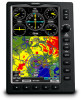
Owners Manual
Page 6
... displayed minimum safe altitudes (MSAs) are based on the Panel are only advisory in the aircraft. GPS altitude should not be used for appropriate minimum clearance altitudes. Databases used in the GPSMAP 695/696 must NOT be used as an aid for VFR navigation. WARNING: Do not use outdated database information. Basemap data is not certified for use this unit for terrain avoidance and does not relieve the pilot from the altitude displayed by GPSMAP 695/696 GPS receiver...
... displayed minimum safe altitudes (MSAs) are based on the Panel are only advisory in the aircraft. GPS altitude should not be used for appropriate minimum clearance altitudes. Databases used in the GPSMAP 695/696 must NOT be used as an aid for VFR navigation. WARNING: Do not use outdated database information. Basemap data is not certified for use this unit for terrain avoidance and does not relieve the pilot from the altitude displayed by GPSMAP 695/696 GPS receiver...
Owners Manual
Page 7
... used for long-range planning purposes only. During flight operations, carefully compare indications from the GPSMAP 695/696 to changes which could affect the accuracy and performance of unsafe operation, carefully review and understand all conceivable system failures is approved only for weather avoidance, not penetration. WARNING: The United States government operates the Global Positioning System and is provided as a precision electronic NAVigation AID (NAVAID). WARNING...
... used for long-range planning purposes only. During flight operations, carefully compare indications from the GPSMAP 695/696 to changes which could affect the accuracy and performance of unsafe operation, carefully review and understand all conceivable system failures is approved only for weather avoidance, not penetration. WARNING: The United States government operates the Global Positioning System and is provided as a precision electronic NAVigation AID (NAVAID). WARNING...

Owners Manual
Page 8
... would like additional information, please refer to penetrate a thunderstorm. NOTE: The data contained in this guide are subject to the following two conditions: (1) this device may cause undesired operation. If you have any thunderstorm identified as safe for anti-reflective coatings. Garmin GPSMAP 695/696 Owner's Manual 190-00919-00 Rev. Warnings, Cautions & Notes WARNING: The illustrations in the terrain and obstacle databases comes from...
... would like additional information, please refer to penetrate a thunderstorm. NOTE: The data contained in this guide are subject to the following two conditions: (1) this device may cause undesired operation. If you have any thunderstorm identified as safe for anti-reflective coatings. Garmin GPSMAP 695/696 Owner's Manual 190-00919-00 Rev. Warnings, Cautions & Notes WARNING: The illustrations in the terrain and obstacle databases comes from...

Owners Manual
Page 12
... Airspace...67 Airspace Alert Messages...68 Smart Airspace...68 2.7 Direct-to Navigation 69 Section 3 Flight Planning 73 3.1 Introduction...73 Data Fields...73 3.2 Flight Plan Creation 74 Adding Waypoints to an Existing Flight Plan 77 3.3 Flight Plan Storage 78 3.4 Flight Plan Activation 80 Editing Speed and Fuel Flow 81 Copying Flight Plans...83 Deleting Flight Plans...84 Inverting a Flight Plan...86 3.5 Approaches...87 Selecting an Approach...88 Activating Vectors-to-Final 90 3.6 Trip Planning...92 Section 4 Hazard Avoidance 93 4.1 XM Weather (GPSMAP 696 93 Activating Services...
... Airspace...67 Airspace Alert Messages...68 Smart Airspace...68 2.7 Direct-to Navigation 69 Section 3 Flight Planning 73 3.1 Introduction...73 Data Fields...73 3.2 Flight Plan Creation 74 Adding Waypoints to an Existing Flight Plan 77 3.3 Flight Plan Storage 78 3.4 Flight Plan Activation 80 Editing Speed and Fuel Flow 81 Copying Flight Plans...83 Deleting Flight Plans...84 Inverting a Flight Plan...86 3.5 Approaches...87 Selecting an Approach...88 Activating Vectors-to-Final 90 3.6 Trip Planning...92 Section 4 Hazard Avoidance 93 4.1 XM Weather (GPSMAP 696 93 Activating Services...

Owners Manual
Page 13
...Data Field Options...136 Abnormal Operation...139 Resetting the Unit...139 Loss of GPS Position...139 Hazard Display with Loss of GPS Position 140 SD Card Use and Databases 141 SD Card Use...141 GPSMAP 695/696 Databases 142 Installation & Interfacing Information 147 Connecting the Power/Data Cable 147 Connecting to a Garmin VHF Comm Radio 148 Connecting to a Computer 149 Information about USB Drivers 149 Using xImage for Customized Waypoint Symbols 150 Connecting the GXM 40 Antenna (GPSMAP 696 150 Connecting to a GTX 330 Mode S Transponder 151 Interfacing...151 Using an external GPS...
...Data Field Options...136 Abnormal Operation...139 Resetting the Unit...139 Loss of GPS Position...139 Hazard Display with Loss of GPS Position 140 SD Card Use and Databases 141 SD Card Use...141 GPSMAP 695/696 Databases 142 Installation & Interfacing Information 147 Connecting the Power/Data Cable 147 Connecting to a Garmin VHF Comm Radio 148 Connecting to a Computer 149 Information about USB Drivers 149 Using xImage for Customized Waypoint Symbols 150 Connecting the GXM 40 Antenna (GPSMAP 696 150 Connecting to a GTX 330 Mode S Transponder 151 Interfacing...151 Using an external GPS...

Owners Manual
Page 17
... hold the POWER Button. Charging the unit's battery pack: 1) Align the notches on the aircraft's battery. D Garmin GPSMAP 695/696 Owner's Manual 3 Appendices Index The unit begins charging as soon as external power is charging. If the battery is present and needs to be used while it does not interfere with aircraft operation. Instead of completely turning off, the unit now goes into Charge Mode. 190-00919-00 Rev. The unit can be charged, the external power source charges the battery while the unit...
... hold the POWER Button. Charging the unit's battery pack: 1) Align the notches on the aircraft's battery. D Garmin GPSMAP 695/696 Owner's Manual 3 Appendices Index The unit begins charging as soon as external power is charging. If the battery is present and needs to be used while it does not interfere with aircraft operation. Instead of completely turning off, the unit now goes into Charge Mode. 190-00919-00 Rev. The unit can be charged, the external power source charges the battery while the unit...

Owners Manual
Page 18
... pilot is shipped from the aircraft. To ensure proper initialization, the GPSMAP 695/696 is prompted to turn the unit on , the receiver must collect satellite data and establish its present location. Pressing the ENT Key acknowledges this information has been reviewed for several days. Turning the Unit On/Off Press and hold the POWER Button to continue. Additional Features Hazard Avoidance Flight Planning Appendices Index Database Initialization 4 Garmin GPSMAP 695/696 Owner's Manual 190...
... pilot is shipped from the aircraft. To ensure proper initialization, the GPSMAP 695/696 is prompted to turn the unit on , the receiver must collect satellite data and establish its present location. Pressing the ENT Key acknowledges this information has been reviewed for several days. Turning the Unit On/Off Press and hold the POWER Button to continue. Additional Features Hazard Avoidance Flight Planning Appendices Index Database Initialization 4 Garmin GPSMAP 695/696 Owner's Manual 190...

Owners Manual
Page 37
..., the CLR Key, the EXIT Softkey or the MENU Key to remove the menu. 190-00919-00 Rev. and press the ENT Key. 3) Turn or move the FMS Joystick to highlight 'System Setup...' Flight Planning Hazard Avoidance Additional Features Appendices Sound Setup Page Units Changing display unit settings: 1) Press the MENU Key twice to display the Main Menu. 2) Turn or move the FMS Joystick to highlight 'Sound...
..., the CLR Key, the EXIT Softkey or the MENU Key to remove the menu. 190-00919-00 Rev. and press the ENT Key. 3) Turn or move the FMS Joystick to highlight 'System Setup...' Flight Planning Hazard Avoidance Additional Features Appendices Sound Setup Page Units Changing display unit settings: 1) Press the MENU Key twice to display the Main Menu. 2) Turn or move the FMS Joystick to highlight 'Sound...
Owners Manual
Page 46
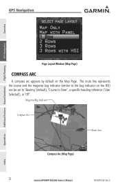
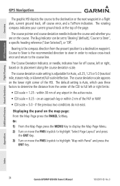
Magenta Bug Indicator Compass Arc Route Line Compass Arc (Map Page) 32 Garmin GPSMAP 695/696 Owner's Manual 190-00919-00 Rev. D Appendices Index GPS Navigation Overview GPS Navigation Additional Features Hazard Avoidance Flight Planning Page Layout Window (Map Page) Compass Arc A compass arc appears by default on the HSI) can be set to 'Bearing' (default), 'Course to the bug indicator on the Map Page. The route line represents the course and the magenta bug indicator (similar to Steer', a specific heading reference ('User Selected'), or 'Off'.
Magenta Bug Indicator Compass Arc Route Line Compass Arc (Map Page) 32 Garmin GPSMAP 695/696 Owner's Manual 190-00919-00 Rev. D Appendices Index GPS Navigation Overview GPS Navigation Additional Features Hazard Avoidance Flight Planning Page Layout Window (Map Page) Compass Arc A compass arc appears by default on the HSI) can be set to 'Bearing' (default), 'Course to the bug indicator on the Map Page. The route line represents the course and the magenta bug indicator (similar to Steer', a specific heading reference ('User Selected'), or 'Off'.
Owners Manual
Page 48
... Index 34 Garmin GPSMAP 695/696 Owner's Manual 190-00919-00 Rev. The Bug Indicator can be set to 'Bearing' (default), 'Course to highlight 'Map with Panel' and press the ENT Key. Course to Steer is Auto, which uses three factors to determine the distance from the present position to a destination waypoint. D The rotating compass indicates your current ground track at the top...
... Index 34 Garmin GPSMAP 695/696 Owner's Manual 190-00919-00 Rev. The Bug Indicator can be set to 'Bearing' (default), 'Course to highlight 'Map with Panel' and press the ENT Key. Course to Steer is Auto, which uses three factors to determine the distance from the present position to a destination waypoint. D The rotating compass indicates your current ground track at the top...

Owners Manual
Page 55
... of the map display to the desired course. D Garmin GPSMAP 695/696 Owner's Manual 41 Appendices Index Changing the Navigation Map orientation: 1) With the Map Page displayed, press the MENU Key. 2) Turn or move the FMS Joystick to highlight 'Set Up Map' and press the ENT Key. 3) Turn the FMS Joystick to highlight the 'North Up On GRND' field. Overview GPS Navigation Map Orientation Maps are relative to where the aircraft is on...
... of the map display to the desired course. D Garmin GPSMAP 695/696 Owner's Manual 41 Appendices Index Changing the Navigation Map orientation: 1) With the Map Page displayed, press the MENU Key. 2) Turn or move the FMS Joystick to highlight 'Set Up Map' and press the ENT Key. 3) Turn the FMS Joystick to highlight the 'North Up On GRND' field. Overview GPS Navigation Map Orientation Maps are relative to where the aircraft is on...

Owners Manual
Page 135
...; Airport Diagrams • Departure Procedures (DP) • Takeoff Minimums • Approaches • Alternate Minimums Displaying FliteCharts: 1) With the Waypoint (WPT) Page displayed, press the CHART Softkey. 2) Press the FMS Joystick to activate the cursor. 3) Turn the FMS Joystick to access a drop-down menu of National Aeronautical Charting Office (NACO) terminal procedures charts. Additional Features Overview GPS Navigation SafeTaxi Cycle Number and Revision SafeTaxi database is...
...; Airport Diagrams • Departure Procedures (DP) • Takeoff Minimums • Approaches • Alternate Minimums Displaying FliteCharts: 1) With the Waypoint (WPT) Page displayed, press the CHART Softkey. 2) Press the FMS Joystick to activate the cursor. 3) Turn the FMS Joystick to access a drop-down menu of National Aeronautical Charting Office (NACO) terminal procedures charts. Additional Features Overview GPS Navigation SafeTaxi Cycle Number and Revision SafeTaxi database is...

Owners Manual
Page 147
... trip. • Lost Satellite Reception-the unit is unable to Ground-the external GPS antenna has an electrical connection problem. D Garmin GPSMAP 695/696 Owner's Manual 133 Appendices Index All MapSource maps are not accessible. • Check XM Antenna-internal problem with the unit. Contact Garmin Product Support. • Database Error-internal problem with your dealer or Garmin Product Support to be recharged. • Can't Unlock Maps-no additional proximity waypoints can be saved. • Proximity Radius...
... trip. • Lost Satellite Reception-the unit is unable to Ground-the external GPS antenna has an electrical connection problem. D Garmin GPSMAP 695/696 Owner's Manual 133 Appendices Index All MapSource maps are not accessible. • Check XM Antenna-internal problem with the unit. Contact Garmin Product Support. • Database Error-internal problem with your dealer or Garmin Product Support to be recharged. • Can't Unlock Maps-no additional proximity waypoints can be saved. • Proximity Radius...

Owners Manual
Page 158
.../country, location (latitude/longitude), frequency, service volume (high, low, terminal), and type (such as VOR-DME, TACAN, and VORTAC). 144 Garmin GPSMAP 695/696 Owner's Manual 190-00919-00 Rev. Updates to the Jeppesen database are initialized and displayed on the splash screen during power-up. The Safe Taxi database contains detailed airport diagrams for the United States only. This database is provided from government agencies. Appendix C Overview GPS Navigation Additional...
.../country, location (latitude/longitude), frequency, service volume (high, low, terminal), and type (such as VOR-DME, TACAN, and VORTAC). 144 Garmin GPSMAP 695/696 Owner's Manual 190-00919-00 Rev. Updates to the Jeppesen database are initialized and displayed on the splash screen during power-up. The Safe Taxi database contains detailed airport diagrams for the United States only. This database is provided from government agencies. Appendix C Overview GPS Navigation Additional...

Owners Manual
Page 159
...; FSS-Flight Service Stations. * Symbology used on a sectional chart. An optional FlightBook software package is consistent with current Jeppesen database points will need to assist with your flight record keeping. If there is a obsolete Jeppesen aviation point in a saved route, the route is locked and unusable. A new route with those used for NDBs, VORs, and airports is available to be created. D Garmin GPSMAP 695/696 Owner's Manual 145 Flight Planning Hazard...
...; FSS-Flight Service Stations. * Symbology used on a sectional chart. An optional FlightBook software package is consistent with current Jeppesen database points will need to assist with your flight record keeping. If there is a obsolete Jeppesen aviation point in a saved route, the route is locked and unusable. A new route with those used for NDBs, VORs, and airports is available to be created. D Garmin GPSMAP 695/696 Owner's Manual 145 Flight Planning Hazard...
Owners Manual
Page 163
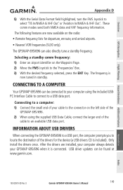
.... D Garmin GPSMAP 695/696 Owner's Manual 149 Overview GPS Navigation Flight Planning Hazard Avoidance Additional Features Appendix D 5) With the Serial Data Format field highlighted, turn the FMS Joystick to your computer using the supplied USB Data Cable, connect the larger end of the drivers for departure, enroute, and arrival airports. • Nearest VOR frequencies (SL30 only). Appendices Index 190-00919-00 Rev. These comm modes send both NMEA data and VHF frequency information. Information about USB Drivers When connecting the GPSMAP 695...
.... D Garmin GPSMAP 695/696 Owner's Manual 149 Overview GPS Navigation Flight Planning Hazard Avoidance Additional Features Appendix D 5) With the Serial Data Format field highlighted, turn the FMS Joystick to your computer using the supplied USB Data Cable, connect the larger end of the drivers for departure, enroute, and arrival airports. • Nearest VOR frequencies (SL30 only). Appendices Index 190-00919-00 Rev. These comm modes send both NMEA data and VHF frequency information. Information about USB Drivers When connecting the GPSMAP 695...
Owners Manual
Page 165
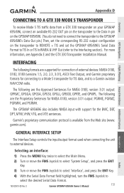
... RS-232 output configuration on the transponder to REMOTE + TIS and set the GPSMAP 695/696's Serial Data Format to TIS In or TIS In/NMEA & VHF Out (refer to the Interfacing section). General Interface Setup The Interface Setup controls the input/output format used when connecting the unit to select the desired Serial Data Format. 190-00919-00 Rev. D Garmin GPSMAP 695/696 Owner's Manual 151 Appendices Index Appendix D Overview GPS Navigation Flight Planning Hazard Avoidance Additional Features Connecting to a GTX 330 Mode S Transponder To receive Mode S TIS traffic data from...
... RS-232 output configuration on the transponder to REMOTE + TIS and set the GPSMAP 695/696's Serial Data Format to TIS In or TIS In/NMEA & VHF Out (refer to the Interfacing section). General Interface Setup The Interface Setup controls the input/output format used when connecting the unit to select the desired Serial Data Format. 190-00919-00 Rev. D Garmin GPSMAP 695/696 Owner's Manual 151 Appendices Index Appendix D Overview GPS Navigation Flight Planning Hazard Avoidance Additional Features Connecting to a GTX 330 Mode S Transponder To receive Mode S TIS traffic data from...

Owners Manual
Page 181
... save up to select cruising speed, maximum speed, fuel flow, and map symbol. Accessing the aircraft profile: 1) Press the MENU Key twice to open the Main Menu. 2) Turn or move the FMS Joystick to define the range for airspeed on the directional gyro or compass into the 'Heading' field, and press the ENT Key. D Garmin GPSMAP 695/696 Owner's Manual 167 Calculating winds aloft: 1) Calculate or enter...
... save up to select cruising speed, maximum speed, fuel flow, and map symbol. Accessing the aircraft profile: 1) Press the MENU Key twice to open the Main Menu. 2) Turn or move the FMS Joystick to define the range for airspeed on the directional gyro or compass into the 'Heading' field, and press the ENT Key. D Garmin GPSMAP 695/696 Owner's Manual 167 Calculating winds aloft: 1) Calculate or enter...
Owners Manual
Page 202
... OTHERWISE. Weather Data Warranty THE WEATHER DATA SOFTWARE PRODUCT IS PROVIDED "AS IS." SUCH REMEDY SHALL BE YOUR SOLE AND EXCLUSIVE REMEDY FOR ANY BREACH OF WARRANTY. Distributor warranties are not accepted for shipping instructions and an RMA tracking number. Appendices Index 188 Garmin GPSMAP 695/696 Owner's Manual 190-00919-00 Rev. Securely pack the unit and a copy of the original sales receipt, which...
... OTHERWISE. Weather Data Warranty THE WEATHER DATA SOFTWARE PRODUCT IS PROVIDED "AS IS." SUCH REMEDY SHALL BE YOUR SOLE AND EXCLUSIVE REMEDY FOR ANY BREACH OF WARRANTY. Distributor warranties are not accepted for shipping instructions and an RMA tracking number. Appendices Index 188 Garmin GPSMAP 695/696 Owner's Manual 190-00919-00 Rev. Securely pack the unit and a copy of the original sales receipt, which...

Owners Manual
Page 204
... this device under Part 15 regulations. Appendices Index 190 Garmin GPSMAP 695/696 Owner's Manual 190-00919-00 Rev. Operation is subject to part 15 of the following two conditions: (1) this device must accept any user-serviceable parts. These limits are designed to radio communications if not installed and used in accordance with the limits for help. D Overview GPS Navigation Additional Features Hazard Avoidance Flight Planning Appendix J XM Satellite Radio Service Agreement XM Satellite Radio...
... this device under Part 15 regulations. Appendices Index 190 Garmin GPSMAP 695/696 Owner's Manual 190-00919-00 Rev. Operation is subject to part 15 of the following two conditions: (1) this device must accept any user-serviceable parts. These limits are designed to radio communications if not installed and used in accordance with the limits for help. D Overview GPS Navigation Additional Features Hazard Avoidance Flight Planning Appendix J XM Satellite Radio Service Agreement XM Satellite Radio...


