Owners Manual
Page 3
Table of Contents Introduction 1 Device Overviews 1 GPSMAP Device Overview (No Camera 1 GPSMAP Device Overview (Camera 1 Battery Information 1 Maximizing Battery Life 1 Turning On Battery Save Mode 1 Long-Term Storage...Sending and Receiving Data Wirelessly 6 Setting a Proximity Alarm 6 Selecting a Profile 6 Area Calculation 6 Calculating the Size of an Area 6 Satellite Page 6 GPS Satellite Settings 6 Garmin Adventures 7 Sending Files to BaseCamp 7 Creating an Adventure 7 Starting an Adventure 7 VIRB® Remote 7 Waypoint Averaging 7 Bluetooth Connected Features 7 Pairing ...
Table of Contents Introduction 1 Device Overviews 1 GPSMAP Device Overview (No Camera 1 GPSMAP Device Overview (Camera 1 Battery Information 1 Maximizing Battery Life 1 Turning On Battery Save Mode 1 Long-Term Storage...Sending and Receiving Data Wirelessly 6 Setting a Proximity Alarm 6 Selecting a Profile 6 Area Calculation 6 Calculating the Size of an Area 6 Satellite Page 6 GPS Satellite Settings 6 Garmin Adventures 7 Sending Files to BaseCamp 7 Creating an Adventure 7 Starting an Adventure 7 VIRB® Remote 7 Waypoint Averaging 7 Bluetooth Connected Features 7 Pairing ...
Owners Manual
Page 5
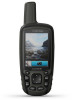
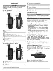
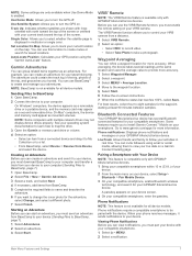
...on the screen, and you do several months, remove the batteries. Device Overviews GPSMAP Device Overview (No Camera) GPS/GNSS antenna Keys Power key Mini-USB port (under weather cap) MCX connector for GPS antenna (under weather cap)1 microSD® card slot (under batteries) Battery compartment... Mounting spine Battery cover D-ring GPSMAP Device Overview (Camera) Mini-USB port (under weather cap) Camera lens microSD card...
...on the screen, and you do several months, remove the batteries. Device Overviews GPSMAP Device Overview (No Camera) GPS/GNSS antenna Keys Power key Mini-USB port (under weather cap) MCX connector for GPS antenna (under weather cap)1 microSD® card slot (under batteries) Battery compartment... Mounting spine Battery cover D-ring GPSMAP Device Overview (Camera) Mini-USB port (under weather cap) Camera lens microSD card...
Owners Manual
Page 7
...Setup. Shaded Relief: Shows detail relief on the trip computer page. When points toward your destination. The device has a 3-axis electronic compass (GPSMAP 64s/sc/st/sx/csx devices only). For accurate information, reset the trip information before beginning a trip. Track Up shows a topdown view with... the appropriate zoom level for a period of time. Showing more slowly. To enable the course pointer, from an electronic compass to a GPS compass when you are traveling directly toward the top of the electronic compass, you are navigating on water or where there are moving long...
...Setup. Shaded Relief: Shows detail relief on the trip computer page. When points toward your destination. The device has a 3-axis electronic compass (GPSMAP 64s/sc/st/sx/csx devices only). For accurate information, reset the trip information before beginning a trip. Track Up shows a topdown view with... the appropriate zoom level for a period of time. Showing more slowly. To enable the course pointer, from an electronic compass to a GPS compass when you are traveling directly toward the top of the electronic compass, you are navigating on water or where there are moving long...
Owners Manual
Page 10
.... Logging the Attempt After you have attempted to find a chirp in a geocache. When you enter an area with GPSMAP 64s/sc/st/sx/csx devices. GPS Satellite Settings Select Satellite > MENU. 6 Main Menu Features and Settings For more information about the cache itself, select Add...a Computer You can send and receive data when paired with another device. Sending and Receiving Data Wirelessly NOTE: This feature is a small Garmin accessory that include a camera. Viewing the Location of the area you want to calculate. 3 Select Calculate when finished. Selecting a Profile ...
.... Logging the Attempt After you have attempted to find a chirp in a geocache. When you enter an area with GPSMAP 64s/sc/st/sx/csx devices. GPS Satellite Settings Select Satellite > MENU. 6 Main Menu Features and Settings For more information about the cache itself, select Add...a Computer You can send and receive data when paired with another device. Sending and Receiving Data Wirelessly NOTE: This feature is a small Garmin accessory that include a camera. Viewing the Location of the area you want to calculate. 3 Select Calculate when finished. Selecting a Profile ...
Owners Manual
Page 11
... -screen instructions. 7 When the confidence status bar reaches 100%, select Save. Go to www.garmin.com/apps for your computer (Sending Files to turn the GPS off. Pairing a Smartphone with GPSMAP 64s/sc/st/sx/csx devices. 1 Bring your compatible smartphone within 10 m (33 ft.) of the... screen or oriented with your device. Use Demo Mode: Allows you to BaseCamp, page 7). 1 Open BaseCamp. 2 Select File > New > Garmin Adventure. 3 Select a...
... -screen instructions. 7 When the confidence status bar reaches 100%, select Save. Go to www.garmin.com/apps for your computer (Sending Files to turn the GPS off. Pairing a Smartphone with GPSMAP 64s/sc/st/sx/csx devices. 1 Bring your compatible smartphone within 10 m (33 ft.) of the... screen or oriented with your device. Use Demo Mode: Allows you to BaseCamp, page 7). 1 Open BaseCamp. 2 Select File > New > Garmin Adventure. 3 Select a...
Owners Manual
Page 12
...of distance traveled for the current lap. For example, if for the current lap. Location (selected): The current position using GPS. Odometer: A running tally of your GPS position. Stopwatch: Allows you have strayed from your current location to the next waypoint on the route. Average: The average ... be navigating for this data to a NMEA® 0183 or NMEA 2000® device capable of day when you are moving based on GPS. Accuracy Of GPS: The margin of error for this data to the change the data fields. 2 Select MENU. 3 Select Change Data Fields. 4 Select...
...of distance traveled for the current lap. For example, if for the current lap. Location (selected): The current position using GPS. Odometer: A running tally of your GPS position. Stopwatch: Allows you have strayed from your current location to the next waypoint on the route. Average: The average ... be navigating for this data to a NMEA® 0183 or NMEA 2000® device capable of day when you are moving based on GPS. Accuracy Of GPS: The margin of error for this data to the change the data fields. 2 Select MENU. 3 Select Change Data Fields. 4 Select...
Owners Manual
Page 13
... system together offers increased performance in challenging environments and faster position acquisition than using GPS only. Serial Interface Settings Select Setup > System > Interface. Garmin Serial: Sets the device to a predetermined altitude. NMEA In/Out: Sets the device to use a Garmin proprietary format to use the device USB port with a computer. RTCM: Allows the...
... system together offers increased performance in challenging environments and faster position acquisition than using GPS only. Serial Interface Settings Select Setup > System > Interface. Garmin Serial: Sets the device to a predetermined altitude. NMEA In/Out: Sets the device to use a Garmin proprietary format to use the device USB port with a computer. RTCM: Allows the...
Owners Manual
Page 14
... default coordinate system is using a map or chart that specifies a different position format. Marine Chart Mode: Sets the type of marine navigation aids on your GPS position. Nautical displays various map features in which the map is low. 1 Select . 2 Use the slider to delete an item from the list. Photo Resolution...
... default coordinate system is using a map or chart that specifies a different position format. Marine Chart Mode: Sets the type of marine navigation aids on your GPS position. Nautical displays various map features in which the map is low. 1 Select . 2 Use the slider to delete an item from the list. Photo Resolution...
Owners Manual
Page 18
... 3 data, transferring 12 data fields 8 deleting, all user data 12 device, registration 11 downloading, geocaches 6 E elevation 4 F files, transferring 6, 12 flashlight 6 G Garmin Connect 7 Garmin Express 11 updating software 11 geocaches 6, 12 downloading 6 GLONASS 9 GPS 6, 9 satellite page 6 settings 9 H HomePort 12 hunting and fishing times 8 K keys 1, 2 L locations editing 4 14 saving 4 M main menu 2 customizing 10 maps 5 measuring...
... 3 data, transferring 12 data fields 8 deleting, all user data 12 device, registration 11 downloading, geocaches 6 E elevation 4 F files, transferring 6, 12 flashlight 6 G Garmin Connect 7 Garmin Express 11 updating software 11 geocaches 6, 12 downloading 6 GLONASS 9 GPS 6, 9 satellite page 6 settings 9 H HomePort 12 hunting and fishing times 8 K keys 1, 2 L locations editing 4 14 saving 4 M main menu 2 customizing 10 maps 5 measuring...

Important Safety and Product Information
Page 2
...apply to: (i) cosmetic damage, such as scratches, nicks and dents; (ii) consumable parts, such as the Global Positioning Service (GPS). Garmin makes no warranty as in the sun in its original warranty, then the new warranty is longer. SOME STATES (AND COUNTRIES AND ... The windshield mount may cause undesired operation of nature or external causes; (iv) damage caused by service performed by one year from Garmin warranty coverage. International Purchases: A separate warranty may impair reception of your windshield clean to help resources available on the vehicle dashboard ....
...apply to: (i) cosmetic damage, such as scratches, nicks and dents; (ii) consumable parts, such as the Global Positioning Service (GPS). Garmin makes no warranty as in the sun in its original warranty, then the new warranty is longer. SOME STATES (AND COUNTRIES AND ... The windshield mount may cause undesired operation of nature or external causes; (iv) damage caused by service performed by one year from Garmin warranty coverage. International Purchases: A separate warranty may impair reception of your windshield clean to help resources available on the vehicle dashboard ....


