Technical Reference for Garmin NMEA 2000 Products
Page 3
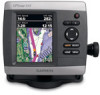
...information for Garmin chartplotters and marine instruments as well as configuration and PGN information for the following products: ◦ GPSMAP® 4000/5000/6000/7000 Series chartplotters ◦ GPSMAP 700 Series chartplotters ◦ GPSMAP 4x1/5x1/5x6 Series chartplotters ◦ GMI™ 10 ◦ GPS 17x &#...basic NMEA 2000 component identification, basic NMEA 2000 network-building instructions, and a list of NMEA 2000specific data used with Garmin NMEA 2000-certified displays and sensors. • The first section, NMEA 2000 Fundamentals, provides descriptions of the NMEA 2000...
...information for Garmin chartplotters and marine instruments as well as configuration and PGN information for the following products: ◦ GPSMAP® 4000/5000/6000/7000 Series chartplotters ◦ GPSMAP 700 Series chartplotters ◦ GPSMAP 4x1/5x1/5x6 Series chartplotters ◦ GMI™ 10 ◦ GPS 17x &#...basic NMEA 2000 component identification, basic NMEA 2000 network-building instructions, and a list of NMEA 2000specific data used with Garmin NMEA 2000-certified displays and sensors. • The first section, NMEA 2000 Fundamentals, provides descriptions of the NMEA 2000...
Technical Reference for Garmin NMEA 2000 Products
Page 4
...)...19 GWS 10 (Garmin Wind Sensor)...20 GHP 10 (Marine Autopilot System)...20 GXM 51...21 VHF 200...21 VHF 300...21 AIS 300...22 AIS 600...22 NMEA 2000-Certified Sensor Configuration Information...23 GPS 17x (GPS Antenna)...23 GFS 10 (Garmin Fuel Sensor)...24 GRA 10 (Garmin Rudder Angle Adapter)...26... GET 10 (Garmin Engine Tilt Adapter...
...)...19 GWS 10 (Garmin Wind Sensor)...20 GHP 10 (Marine Autopilot System)...20 GXM 51...21 VHF 200...21 VHF 300...21 AIS 300...22 AIS 600...22 NMEA 2000-Certified Sensor Configuration Information...23 GPS 17x (GPS Antenna)...23 GFS 10 (Garmin Fuel Sensor)...24 GRA 10 (Garmin Rudder Angle Adapter)...26... GET 10 (Garmin Engine Tilt Adapter...
Technical Reference for Garmin NMEA 2000 Products
Page 22
..., Engine Receive 059392 059904 060928 126208 127489 127497 127505 127505 Fluid Level (when calibrated using a Garmin chartplotter or marine instrument) GRA 10 (Garmin Rudder Angle Adapter) Transmit Receive 059392 ISO Acknowledgment 059392 060928 ISO Address Claim 059904 126208 NMEA -...Information NMEA 2000-Certified Sensor PGN Information The following tables list the non-proprietary PGN information for Garmin NMEA 2000 Products GPS 17x (GPS Antenna) Transmit Receive 059392 060928 126208 126464 126992 126996 129025 129026 129029 129539 129540 ISO Acknowledgment ISO...
..., Engine Receive 059392 059904 060928 126208 127489 127497 127505 127505 Fluid Level (when calibrated using a Garmin chartplotter or marine instrument) GRA 10 (Garmin Rudder Angle Adapter) Transmit Receive 059392 ISO Acknowledgment 059392 060928 ISO Address Claim 059904 126208 NMEA -...Information NMEA 2000-Certified Sensor PGN Information The following tables list the non-proprietary PGN information for Garmin NMEA 2000 Products GPS 17x (GPS Antenna) Transmit Receive 059392 060928 126208 126464 126992 126996 129025 129026 129029 129539 129540 ISO Acknowledgment ISO...
Technical Reference for Garmin NMEA 2000 Products
Page 28
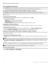
...Calibration > Reset Calibration. 24 Technical Reference for fuel-level information. Using Fuel-Flow Information With a Garmin Chartplotter or Marine Instrument Caution: The Garmin chartplotter or marine instrument must specify the amount of fuel currently available in still water, on the fuel-flow rate...Garmin Fuel Sensor) Caution: The GFS 10 is a sensor that corresponds to the current fuel level in addition to the GFS 10, to calculate fuel economy. While viewing the fuel page or fuel instrument screen on your NMEA 2000 device, select Menu > Fuel Economy Source. 2. Select either GPS...
...Calibration > Reset Calibration. 24 Technical Reference for fuel-level information. Using Fuel-Flow Information With a Garmin Chartplotter or Marine Instrument Caution: The Garmin chartplotter or marine instrument must specify the amount of fuel currently available in still water, on the fuel-flow rate...Garmin Fuel Sensor) Caution: The GFS 10 is a sensor that corresponds to the current fuel level in addition to the GFS 10, to calculate fuel economy. While viewing the fuel page or fuel instrument screen on your NMEA 2000 device, select Menu > Fuel Economy Source. 2. Select either GPS...
Owner's Manual
Page 4
...Garmin iv Getting Started 1 Unit Overview 1 Turning the Unit On or Off 2 Initializing Unit Settings 3 Adjusting the Backlight 4 Using the Keypad 5 Acquiring GPS... Satellite Signals 5 Using Simulator Mode 5 Viewing System Information 6 Restoring the Original Factory Settings 6 Inserting and Removing SD Cards 6 Understanding the Home Screen 7 Using Charts 8 Using the Navigation Chart 8 Changing the Navigation Chart Settings 12 Using the Split Navigation Chart 15 Using Perspective 3D 15 ii Using Mariner... Vision 34 Navigating with a Garmin Autopilot 35 Viewing Information 36 ...
...Garmin iv Getting Started 1 Unit Overview 1 Turning the Unit On or Off 2 Initializing Unit Settings 3 Adjusting the Backlight 4 Using the Keypad 5 Acquiring GPS... Satellite Signals 5 Using Simulator Mode 5 Viewing System Information 6 Restoring the Original Factory Settings 6 Inserting and Removing SD Cards 6 Understanding the Home Screen 7 Using Charts 8 Using the Navigation Chart 8 Changing the Navigation Chart Settings 12 Using the Split Navigation Chart 15 Using Perspective 3D 15 ii Using Mariner... Vision 34 Navigating with a Garmin Autopilot 35 Viewing Information 36 ...
Owner's Manual
Page 32
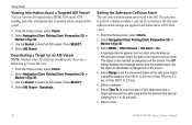
... object is used with AIS. From the Home screen, select Charts. 2. Select a time. 26 GPSMAP 400/500 Series Owner's Manual Select AIS Vessel. Select Time To to sound an alarm if AIS determines...use a BlueChart g2 Vision SD card. 1. Select Navigation Chart, Fishing Chart, Perspective 3D, or Mariner's Eye 3D. 3. The Off setting disables the message banner and the audible alarm, but the ...Viewing Information about a Targeted AIS Vessel You can view the AIS signal status, MMSI, GPS speed, GPS heading, and other information that a target will intersect the safe zone within the defined ...
... object is used with AIS. From the Home screen, select Charts. 2. Select a time. 26 GPSMAP 400/500 Series Owner's Manual Select AIS Vessel. Select Time To to sound an alarm if AIS determines...use a BlueChart g2 Vision SD card. 1. Select Navigation Chart, Fishing Chart, Perspective 3D, or Mariner's Eye 3D. 3. The Off setting disables the message banner and the audible alarm, but the ...Viewing Information about a Targeted AIS Vessel You can view the AIS signal status, MMSI, GPS speed, GPS heading, and other information that a target will intersect the safe zone within the defined ...

Owner's Manual
Page 41
... environments, you to get the most out of the land and water on BlueChart g2 Vision-compatible Garmin GPS units and when using HomePort. The BlueChart g2 Vision Mariner's Eye 3D is installed on a large metal object before handling the card to prevent damage to ...high-resolution satellite images for a realistic view of your destination (page 49). GPSMAP 400/500 Series Owner's Manual 35 Navigating with NMEA 2000 compatible chartplotters (GPSMAP 441/441s, GPSMAP 536/536s, GPSMAP 541/541s, and GPSMAP 546/546s). BlueChart g2 Vision data cards are prompted to engage the autopilot. ...
... environments, you to get the most out of the land and water on BlueChart g2 Vision-compatible Garmin GPS units and when using HomePort. The BlueChart g2 Vision Mariner's Eye 3D is installed on a large metal object before handling the card to prevent damage to ...high-resolution satellite images for a realistic view of your destination (page 49). GPSMAP 400/500 Series Owner's Manual 35 Navigating with NMEA 2000 compatible chartplotters (GPSMAP 441/441s, GPSMAP 536/536s, GPSMAP 541/541s, and GPSMAP 546/546s). BlueChart g2 Vision data cards are prompted to engage the autopilot. ...

Owner's Manual
Page 91
...53 battery 53 clock 53 collision 26 deep water 53 fish 54 fuel 54 GPS accuracy 53 navigation 53 off course 53 shallow water 53 sonar 53 water temp... eye 3D 18 settings 18 fishing chart 19 AIS 27 MARPA 27 fishing information 73 GPSMAP 400/500 Series Owner's Manual 85 Ref. Time 49 barometric pressure trend 49 Beeper/...Chart Borders 14 chart data 10 charts detail 13 fish eye 3D 18 fishing 19 mariner's eye 3D 16 navigation 8 settings 12 cleaning the unit 82 Clear User Data...rose 12 contact information, Garmin iv coordinates, grid creating waypoints using 30 course up data 46 backlight, adjusting 4 Baro...
...53 battery 53 clock 53 collision 26 deep water 53 fish 54 fuel 54 GPS accuracy 53 navigation 53 off course 53 shallow water 53 sonar 53 water temp... eye 3D 18 settings 18 fishing chart 19 AIS 27 MARPA 27 fishing information 73 GPSMAP 400/500 Series Owner's Manual 85 Ref. Time 49 barometric pressure trend 49 Beeper/...Chart Borders 14 chart data 10 charts detail 13 fish eye 3D 18 fishing 19 mariner's eye 3D 16 navigation 8 settings 12 cleaning the unit 82 Clear User Data...rose 12 contact information, Garmin iv coordinates, grid creating waypoints using 30 course up data 46 backlight, adjusting 4 Baro...
Owner's Manual
Page 92
...synchronizing 40 viewing 40 full screen, sonar 57 Full Screen Map 9 fuse 78 G gain 61 Garmin Data Transfer 51 go to 28 GPS 5, 48, 78 GPS heading 42 Grid (North) 49 grid coordinates creating waypoints using 30 ground wind 41 guide to...72 M magnetic heading 42 man overboard 30, 65 Manual Zoom 61 map datum 49 MapSource data 44 Mariner's Eye 3D AIS 27 MARPA 27 mariner's eye 3D colors 17 mark current location 30 MARK key 5 MARPA threats 27 measuring distance 31 MENU...Power/Backlight key 5 power source 78 product registration iv Proj. Heading 25 Q quick links i GPSMAP 400/500 Series Owner's Manual
...synchronizing 40 viewing 40 full screen, sonar 57 Full Screen Map 9 fuse 78 G gain 61 Garmin Data Transfer 51 go to 28 GPS 5, 48, 78 GPS heading 42 Grid (North) 49 grid coordinates creating waypoints using 30 ground wind 41 guide to...72 M magnetic heading 42 man overboard 30, 65 Manual Zoom 61 map datum 49 MapSource data 44 Mariner's Eye 3D AIS 27 MARPA 27 mariner's eye 3D colors 17 mark current location 30 MARK key 5 MARPA threats 27 measuring distance 31 MENU...Power/Backlight key 5 power source 78 product registration iv Proj. Heading 25 Q quick links i GPSMAP 400/500 Series Owner's Manual
Owner's Manual
Page 4
...Garmin iv Getting Started 1 Unit Overview 1 Turning the Unit On or Off 3 Initializing Unit Settings 3 Adjusting the Backlight 4 Using the Keypad 5 Acquiring GPS... Satellite Signals 5 Using Simulator Mode 6 Viewing System Information 6 Restoring the Original Factory Settings 6 Inserting and Removing SD Cards 6 Understanding the Home Screen 7 Using Charts 8 Using the Navigation Chart 8 Changing the Navigation Chart Settings 12 Using the Split Navigation Chart 15 Using Perspective 3D 15 ii Using Mariner... Vision 33 Navigating with a Garmin Autopilot 33 Viewing Information 34 ...
...Garmin iv Getting Started 1 Unit Overview 1 Turning the Unit On or Off 3 Initializing Unit Settings 3 Adjusting the Backlight 4 Using the Keypad 5 Acquiring GPS... Satellite Signals 5 Using Simulator Mode 6 Viewing System Information 6 Restoring the Original Factory Settings 6 Inserting and Removing SD Cards 6 Understanding the Home Screen 7 Using Charts 8 Using the Navigation Chart 8 Changing the Navigation Chart Settings 12 Using the Split Navigation Chart 15 Using Perspective 3D 15 ii Using Mariner... Vision 33 Navigating with a Garmin Autopilot 33 Viewing Information 34 ...
Owner's Manual
Page 31
... 3D, or Mariner's Eye 3D. 3. Select Navigation Chart, Fishing Chart, Perspective 3D, or Mariner's Eye 3D. 3. From the Home screen, select Charts. 2. Using Charts Viewing Information about a Targeted AIS Vessel You can view the AIS signal status, MMSI, GPS speed, GPS heading, and other...the Rocker and SELECT button to select the AIS vessel. 4. Select Navigation Chart, Fishing Chart, Perspective 3D, or Mariner's Eye 3D. 3. Select AIS Vessel > Deactivate. GPSMAP 400/500 Series Owner's Manual 25 Select AIS Vessel > Activate Target. From the Home screen, select Charts. 2....
... 3D, or Mariner's Eye 3D. 3. Select Navigation Chart, Fishing Chart, Perspective 3D, or Mariner's Eye 3D. 3. From the Home screen, select Charts. 2. Using Charts Viewing Information about a Targeted AIS Vessel You can view the AIS signal status, MMSI, GPS speed, GPS heading, and other...the Rocker and SELECT button to select the AIS vessel. 4. Select Navigation Chart, Fishing Chart, Perspective 3D, or Mariner's Eye 3D. 3. Select AIS Vessel > Deactivate. GPSMAP 400/500 Series Owner's Manual 25 Select AIS Vessel > Activate Target. From the Home screen, select Charts. 2....
Owner's Manual
Page 39
...Vision data from above and behind the boat for a three-dimensional navigation aid (page 16). GPSMAP 400/500 Series Owner's Manual 33 This chart works well for offshore deep-sea fishing. &#...provides a view of marinas and other points of interest (POIs) along the shore. The BlueChart g2 Vision Mariner's Eye 3D is more detailed than the preloaded data. • Fish Eye 3D-provides an underwater 3D view...visually represents the sea floor according to the information on BlueChart g2 Vision-compatible Garmin GPS units. You can only use the SD card on the chart. • Fishing Charts-provides a view...
...Vision data from above and behind the boat for a three-dimensional navigation aid (page 16). GPSMAP 400/500 Series Owner's Manual 33 This chart works well for offshore deep-sea fishing. &#...provides a view of marinas and other points of interest (POIs) along the shore. The BlueChart g2 Vision Mariner's Eye 3D is more detailed than the preloaded data. • Fish Eye 3D-provides an underwater 3D view...visually represents the sea floor according to the information on BlueChart g2 Vision-compatible Garmin GPS units. You can only use the SD card on the chart. • Fishing Charts-provides a view...
Owner's Manual
Page 83
...49 arrival 45 battery 46 clock 46 collision 26, 49 deep water 46 fish 46 fuel 47 GPS accuracy 46 navigation 45 safe-zone 49 shallow water 46 sonar 46 water temp 46 weather 47...Speed 48 Chart/Sonar screen using 21 chart data 10 charts detail 14 fish eye 3D 18 fishing 19 mariner's eye 3D 16 navigation 8 settings 12 cleaning the unit 74 Clear User Data 37 collision alarm 26,... 49 colors, hazard 17 Color Scheme 53 Communications 44 Compass 34 compass rose 12 contact information, Garmin iv GPSMAP 400/500 Series Owner's Manual course up 13 current stations 36 customizing chart settings 12 D dashboard...
...49 arrival 45 battery 46 clock 46 collision 26, 49 deep water 46 fish 46 fuel 47 GPS accuracy 46 navigation 45 safe-zone 49 shallow water 46 sonar 46 water temp 46 weather 47...Speed 48 Chart/Sonar screen using 21 chart data 10 charts detail 14 fish eye 3D 18 fishing 19 mariner's eye 3D 16 navigation 8 settings 12 cleaning the unit 74 Clear User Data 37 collision alarm 26,... 49 colors, hazard 17 Color Scheme 53 Communications 44 Compass 34 compass rose 12 contact information, Garmin iv GPSMAP 400/500 Series Owner's Manual course up 13 current stations 36 customizing chart settings 12 D dashboard...


