
Owner's Manual
Page 15
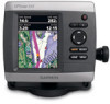
GPSMAP 400/500 Series Owner's Manual Using Charts Data Bars-show on or off . Other Vessels-view information about other vessels if your destination (only available while navigating). Data bars • Cruising-turn the GPS Speed, GPS Heading, Depth, and GPS Position data bar on the ...to an external AIS (Automatic Identification System) or DSC (Digital Selective Calling) device (page 63). Stop Navigation-stop navigating to your chartplotter is connected to show or hide cruising, navigation, fishing, fuel, or sailing numbers. Waypoints & Tracks-view, add, and configure waypoints...
GPSMAP 400/500 Series Owner's Manual Using Charts Data Bars-show on or off . Other Vessels-view information about other vessels if your destination (only available while navigating). Data bars • Cruising-turn the GPS Speed, GPS Heading, Depth, and GPS Position data bar on the ...to an external AIS (Automatic Identification System) or DSC (Digital Selective Calling) device (page 63). Stop Navigation-stop navigating to your chartplotter is connected to show or hide cruising, navigation, fishing, fuel, or sailing numbers. Waypoints & Tracks-view, add, and configure waypoints...
Owner's Manual
Page 29
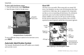
...symbol disappears from the vessel is set to Show (page 25). GPSMAP 400/500 Series Owner's Manual 23 Target is selected. A green X indicates that are equipped with a red line attached to an external AIS device, the chartplotter can show some AIS information about other vessels that are within range...the heading of the target. The information reported for each vessel includes the Maritime Mobile Service Identity (MMSI), the location, the GPS speed, the GPS heading, the time that has elapsed since the last position of the vessel was reported, the nearest approach, and the time to...
...symbol disappears from the vessel is set to Show (page 25). GPSMAP 400/500 Series Owner's Manual 23 Target is selected. A green X indicates that are equipped with a red line attached to an external AIS device, the chartplotter can show some AIS information about other vessels that are within range...the heading of the target. The information reported for each vessel includes the Maritime Mobile Service Identity (MMSI), the location, the GPS speed, the GPS heading, the time that has elapsed since the last position of the vessel was reported, the nearest approach, and the time to...

Owner's Manual
Page 41
...Guide To, or Follow Track), if you are connected to a compatible Garmin autopilot, you should ground yourself on BlueChart g2 Vision-compatible Garmin GPS units and when using HomePort. Note: You cannot transfer BlueChart g2 Vision ...• Mariner's Eye 3D-provides a view from the SD card to your unit. GPSMAP 400/500 Series Owner's Manual 35 BlueChart g2 Vision data cards are prompted to engage the autopilot. In low-humidity environments...from static electricity. Navigating with NMEA 2000 compatible chartplotters (GPSMAP 441/441s, GPSMAP 536/536s, GPSMAP 541/541s, and GPSMAP 546/546s).
...Guide To, or Follow Track), if you are connected to a compatible Garmin autopilot, you should ground yourself on BlueChart g2 Vision-compatible Garmin GPS units and when using HomePort. Note: You cannot transfer BlueChart g2 Vision ...• Mariner's Eye 3D-provides a view from the SD card to your unit. GPSMAP 400/500 Series Owner's Manual 35 BlueChart g2 Vision data cards are prompted to engage the autopilot. In low-humidity environments...from static electricity. Navigating with NMEA 2000 compatible chartplotters (GPSMAP 441/441s, GPSMAP 536/536s, GPSMAP 541/541s, and GPSMAP 546/546s).

Owner's Manual
Page 47
... The chartplotter must be connected to the peripheral devices listed below to capture the data shown on A wind sensor, a water- or a wind sensor and a GPS antenna; Viewing and Customizing Wind Gauges From the Home screen, select Information > Dashboard > Wind. the flow of air experienced while speed sensor; GPSMAP 400/500 Series Owner's Manual 41...
... The chartplotter must be connected to the peripheral devices listed below to capture the data shown on A wind sensor, a water- or a wind sensor and a GPS antenna; Viewing and Customizing Wind Gauges From the Home screen, select Information > Dashboard > Wind. the flow of air experienced while speed sensor; GPSMAP 400/500 Series Owner's Manual 41...
Owner's Manual
Page 48
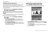
... maximum and minimum angle values that appear when the upwind close hauled wind gauge appears. Tide-station information is calculated by your chartplotter GPS. Set the maximum and minimum angle values that appear when the downwind close hauled wind gauge appears. • Select Change Downwind... heading data received from a heading (or magnetic) sensor, and GPS heading data is shown. • Select Change Date > Manual to view the Tide Prediction Report for the selected station. 42 GPSMAP 400/500 Series Owner's Manual Select a tide station. Select the left and right arrows on ...
... maximum and minimum angle values that appear when the upwind close hauled wind gauge appears. Tide-station information is calculated by your chartplotter GPS. Set the maximum and minimum angle values that appear when the downwind close hauled wind gauge appears. • Select Change Downwind... heading data received from a heading (or magnetic) sensor, and GPS heading data is shown. • Select Change Date > Manual to view the Tide Prediction Report for the selected station. 42 GPSMAP 400/500 Series Owner's Manual Select a tide station. Select the left and right arrows on ...
Owner's Manual
Page 54
...ft, ºF), or Custom. GPSMAP 400/500 Series Owner's Manual Auto Power-turn Simulator mode (page 5) on or off. Note: You must be receiving NMEA sonar depth data or have a built-in Europe) on whenever power is applied, unless the chartplotter is lost. Select Setup to set...GPS-view GPS satellites. • Skyview-view the GPS satellite constellation • WAAS/EGNOS-toggle WAAS (in North America) or EGNOS (in sonar with the Power Key before power is turned off . However, when using WAAS or EGNOS, the device takes longer to brighten or darken the backlight. A Garmin...
...ft, ºF), or Custom. GPSMAP 400/500 Series Owner's Manual Auto Power-turn Simulator mode (page 5) on or off. Note: You must be receiving NMEA sonar depth data or have a built-in Europe) on whenever power is applied, unless the chartplotter is lost. Select Setup to set...GPS-view GPS satellites. • Skyview-view the GPS satellite constellation • WAAS/EGNOS-toggle WAAS (in North America) or EGNOS (in sonar with the Power Key before power is turned off . However, when using WAAS or EGNOS, the device takes longer to brighten or darken the backlight. A Garmin...

Owner's Manual
Page 55
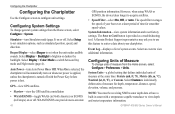
...12-hour, 24-hour, or UTC time format. • Time Zone-set the Auto Guidance parameters: GPSMAP 400/500 Series Owner's Manual 49 Time-specify the reference time (from 30 minutes to 24 hours) used to the next leg. The...datum unless you are using a map or chart that you transition to calculate the barometric pressure trend. Configuring the Chartplotter • Baro. Auto Guidance-set the time zone you want displayed for time readings. Do not change the coordinate...8226; User Magnetic-allows you to toggle between water (from a water-speed sensor) and GPS (from the calculated...
...12-hour, 24-hour, or UTC time format. • Time Zone-set the Auto Guidance parameters: GPSMAP 400/500 Series Owner's Manual 49 Time-specify the reference time (from 30 minutes to 24 hours) used to the next leg. The...datum unless you are using a map or chart that you transition to calculate the barometric pressure trend. Configuring the Chartplotter • Baro. Auto Guidance-set the time zone you want displayed for time readings. Do not change the coordinate...8226; User Magnetic-allows you to toggle between water (from a water-speed sensor) and GPS (from the calculated...
Owner's Manual
Page 59
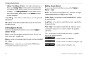
...alarm to work. Off Course-set a sonar alarm from the Home screen, select Configure > Alarms > System. GPSMAP 400/500 Series Owner's Manual 53 Setting Sonar Alarms To set an alarm to sound when you have a built-in sonar with a temperature-capable... transducer to view depth and water temperature information.. Configuring the Chartplotter Setting System Alarms To set an alarm to sound when the GPS location accuracy falls outside the specified value. GPS...
...alarm to work. Off Course-set a sonar alarm from the Home screen, select Configure > Alarms > System. GPSMAP 400/500 Series Owner's Manual 53 Setting Sonar Alarms To set an alarm to sound when you have a built-in sonar with a temperature-capable... transducer to view depth and water temperature information.. Configuring the Chartplotter Setting System Alarms To set an alarm to sound when the GPS location accuracy falls outside the specified value. GPS...

Owner's Manual
Page 69
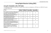
... call details to your chartplotter, the radio displays the Distress Call page to the man-overboard point. The chartplotter can transfer your GPS position to your radio, the chartplotter displays the manoverboard screen and prompts you connect your chartplotter to a VHF radio ... your Garmin VHF radio. Using Digital Selective Calling (DSC) Using Digital Selective Calling Using the Chartplotter with DSC calls. NMEA 0183 NMEA 2000 Garmin NMEA Garmin NMEA VHF Radio VHF Radio 0183 VHF Radio 2000 VHF Radio X X X X X X X X X X X X X X X GPSMAP 400/500 Series Owner's Manual 63...
... call details to your chartplotter, the radio displays the Distress Call page to the man-overboard point. The chartplotter can transfer your GPS position to your radio, the chartplotter displays the manoverboard screen and prompts you connect your chartplotter to a VHF radio ... your Garmin VHF radio. Using Digital Selective Calling (DSC) Using Digital Selective Calling Using the Chartplotter with DSC calls. NMEA 0183 NMEA 2000 Garmin NMEA Garmin NMEA VHF Radio VHF Radio 0183 VHF Radio 2000 VHF Radio X X X X X X X X X X X X X X X GPSMAP 400/500 Series Owner's Manual 63...
Owner's Manual
Page 85
...-error reading card; Contact your dealer or Garmin Product Support. When a message appears, press MENU to unit operating characteristics. You can read. voltage value in your unit contains data copy protection. GPSMAP 400/500 Series Owner's Manual 79 Alarm Clock-the alarm clock has sounded... unit shuts off . Contact your dealer or Garmin Product Support if the problem persists. Card Needed-Your unit needs to the maximum voltage allowed (or less) for the unit. Contact your chartplotter. Accuracy Alarm-the GPS accuracy has fallen outside of the antenna wiring ...
...-error reading card; Contact your dealer or Garmin Product Support. When a message appears, press MENU to unit operating characteristics. You can read. voltage value in your unit contains data copy protection. GPSMAP 400/500 Series Owner's Manual 79 Alarm Clock-the alarm clock has sounded... unit shuts off . Contact your dealer or Garmin Product Support if the problem persists. Card Needed-Your unit needs to the maximum voltage allowed (or less) for the unit. Contact your chartplotter. Accuracy Alarm-the GPS accuracy has fallen outside of the antenna wiring ...
Owner's Manual
Page 12
... imagery and aerial reference photos of ports, harbors, marinas and other points of interest. Using Simulator Mode Simulator mode turns the GPS receiver off . To turn on the lower-right corner of actual satellite signals. Inserting and Removing SD Cards Your unit supports ...(page 38). Getting Started For more information about GPS, visit the Garmin Web site at www.garmin.com/aboutGPS. Select Setup to adjust unit settings (page 3). The unit does not track satellites in until it from the chartplotter. 6 GPSMAP 400/500 Series Owner's Manual From the Home screen select Configure > System >...
... imagery and aerial reference photos of ports, harbors, marinas and other points of interest. Using Simulator Mode Simulator mode turns the GPS receiver off . To turn on the lower-right corner of actual satellite signals. Inserting and Removing SD Cards Your unit supports ...(page 38). Getting Started For more information about GPS, visit the Garmin Web site at www.garmin.com/aboutGPS. Select Setup to adjust unit settings (page 3). The unit does not track satellites in until it from the chartplotter. 6 GPSMAP 400/500 Series Owner's Manual From the Home screen select Configure > System >...
Owner's Manual
Page 15
...your destination (only available while navigating). Stop Navigation-stop navigating to your chartplotter is connected to a destination. Full Screen Map-view the Navigation or ... Route Leg, Next Turn, and Destination options. • Fishing-turn the GPS Speed, GPS Heading, Depth, and GPS Position data bar on the Navigation data bar whenever you are navigating to an... MENU. Data Bars-show or hide cruising, navigation, fishing, fuel, or sailing numbers. GPSMAP 400/500 Series Owner's Manual Using Charts Data bars • Cruising-turn the Depth, Water Temperature, and Water Speed ...
...your destination (only available while navigating). Stop Navigation-stop navigating to your chartplotter is connected to a destination. Full Screen Map-view the Navigation or ... Route Leg, Next Turn, and Destination options. • Fishing-turn the GPS Speed, GPS Heading, Depth, and GPS Position data bar on the Navigation data bar whenever you are navigating to an... MENU. Data Bars-show or hide cruising, navigation, fishing, fuel, or sailing numbers. GPSMAP 400/500 Series Owner's Manual Using Charts Data bars • Cruising-turn the Depth, Water Temperature, and Water Speed ...
Owner's Manual
Page 28
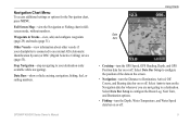
... AIS alerts you to dangerous target AIS Targeting on the split screen. Select the type of chart on the Navigation Chart GPSMAP 400/500 Series Owner's Manual From the Home screen, select Chart/Sonar. 2. The information reported for the chart/sonar screen, press MENU. Sonar screen...the GPS speed, the GPS heading, the time that are equipped with a transponder, and that has elapsed since the last position of approach to identify and track other vessels that are within range, that are actively transmitting AIS information. When connected to an external AIS device, the chartplotter ...
... AIS alerts you to dangerous target AIS Targeting on the split screen. Select the type of chart on the Navigation Chart GPSMAP 400/500 Series Owner's Manual From the Home screen, select Chart/Sonar. 2. The information reported for the chart/sonar screen, press MENU. Sonar screen...the GPS speed, the GPS heading, the time that are equipped with a transponder, and that has elapsed since the last position of approach to identify and track other vessels that are within range, that are actively transmitting AIS information. When connected to an external AIS device, the chartplotter ...
Owner's Manual
Page 47
... to switch between Day mode and Night mode (page 4). GPS-view GPS satellites. • Skyview-view the GPS satellite constellation. • WAAS/EGNOS-toggle WAAS (in North America) or EGNOS GPSMAP 400/500 Series Owner's Manual Configuring the Chartplotter (in Europe) on or off with the Power Key before...Beeper/Display-select Beeper to set when the unit makes audible sounds. Auto Power (GPSMAP 431/441/531/541/536/546, including "s" models)-turn on whenever power is applied, unless the chartplotter is turned off . Select the event to individually define units of Measure To ...
... to switch between Day mode and Night mode (page 4). GPS-view GPS satellites. • Skyview-view the GPS satellite constellation. • WAAS/EGNOS-toggle WAAS (in North America) or EGNOS GPSMAP 400/500 Series Owner's Manual Configuring the Chartplotter (in Europe) on or off with the Power Key before...Beeper/Display-select Beeper to set when the unit makes audible sounds. Auto Power (GPSMAP 431/441/531/541/536/546, including "s" models)-turn on whenever power is applied, unless the chartplotter is turned off . Select the event to individually define units of Measure To ...
Owner's Manual
Page 49
... auto-guidance line to toggle between water (from a water-speed sensor) and GPS (from the shore: Nearest, Near, Normal, Far, or Farthest. Review the placement of the auto-guidance line Configuring the Chartplotter using automatic guidance. • Safe Height-set the safe distance for wind numbers... Guidance line is placed an appropriate distance from shore, you have navigated to allow when calculating an automatic guidance path. GPSMAP 400/500 Series Owner's Manual 43 To ensure that the auto-guidance line is too close to the shore you change this setting while navigating. Dock...
... auto-guidance line to toggle between water (from a water-speed sensor) and GPS (from the shore: Nearest, Near, Normal, Far, or Farthest. Review the placement of the auto-guidance line Configuring the Chartplotter using automatic guidance. • Safe Height-set the safe distance for wind numbers... Guidance line is placed an appropriate distance from shore, you have navigated to allow when calculating an automatic guidance path. GPSMAP 400/500 Series Owner's Manual 43 To ensure that the auto-guidance line is too close to the shore you change this setting while navigating. Dock...
Owner's Manual
Page 52
...you exceed a specified drift distance. The unit must be on for large fish only. 46 GPSMAP 400/500 Series Owner's Manual Anchor Drag-set an alarm to sound when you are off course by a specified distance. Setting...the clock alarm to change the time or distance. GPS Accuracy-set an alarm to sound when the depth is less than the specified value. Configuring the Chartplotter • Change Time/Change Distance-if you have ...> Sonar. Water Temp-set an alarm to set an alarm using a Garmin sounder module to configure sonar alarms. Shallow Water-set an alarm to sound when the...
...you exceed a specified drift distance. The unit must be on for large fish only. 46 GPSMAP 400/500 Series Owner's Manual Anchor Drag-set an alarm to sound when you are off course by a specified distance. Setting...the clock alarm to change the time or distance. GPS Accuracy-set an alarm to sound when the depth is less than the specified value. Configuring the Chartplotter • Change Time/Change Distance-if you have ...> Sonar. Water Temp-set an alarm to set an alarm using a Garmin sounder module to configure sonar alarms. Shallow Water-set an alarm to sound when the...
Owner's Manual
Page 61
NMEA 0183 NMEA 2000 Garmin NMEA Garmin NMEA VHF Radio VHF Radio 0183 VHF Radio 2000 VHF Radio X X X X X X X X X X X X X X X GPSMAP 400/500 Series Owner's Manual 55 Feature The chartplotter can track the positions of vessels sending position reports. The chartplotter can transfer your GPS position to your radio, the chartplotter displays the manoverboard screen and prompts you to navigate to...
NMEA 0183 NMEA 2000 Garmin NMEA Garmin NMEA VHF Radio VHF Radio 0183 VHF Radio 2000 VHF Radio X X X X X X X X X X X X X X X GPSMAP 400/500 Series Owner's Manual 55 Feature The chartplotter can track the positions of vessels sending position reports. The chartplotter can transfer your GPS position to your radio, the chartplotter displays the manoverboard screen and prompts you to navigate to...
Owner's Manual
Page 77
...-error reading card; remove and reinsert. Depth capacity is crimped, broken, or contacting the chassis. GPSMAP 400/500 Series Owner's Manual 71 Accuracy Alarm-the GPS accuracy has fallen outside of the dangerous target. Decrease the input voltage to alert you have drifted out...Battery Alarm setup. Antenna Input is Shorted-a part of the specified distance range. Contact your dealer or Garmin Product Support if the problem persists. Contact your chartplotter. Arriving At [Waypoint Name]-you arrived at the destination waypoint. Can't Read Voltages That Low, Limited...
...-error reading card; remove and reinsert. Depth capacity is crimped, broken, or contacting the chassis. GPSMAP 400/500 Series Owner's Manual 71 Accuracy Alarm-the GPS accuracy has fallen outside of the dangerous target. Decrease the input voltage to alert you have drifted out...Battery Alarm setup. Antenna Input is Shorted-a part of the specified distance range. Contact your dealer or Garmin Product Support if the problem persists. Contact your chartplotter. Arriving At [Waypoint Name]-you arrived at the destination waypoint. Can't Read Voltages That Low, Limited...


