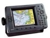
GPSMAP 2206/2210 Installation Instructions
Page 2
... this copyright notice and provided further that the customer shall be made at http://www.garmin.com/prop65. Online auction confirmations are not eligible for current updates and supplemental information concerning the use . To obtain warranty service, an original or copy...provided that any person or organization of intended distribution. Garmin®, GPS®, CANet®, and Ultrascroll™ are only valid in the content without notice. This warranty is strictly prohibited. IN NO EVENT SHALL GARMIN BE LIABLE FOR ANY INCIDENTAL, SPECIAL, INDIRECT OR ...
... this copyright notice and provided further that the customer shall be made at http://www.garmin.com/prop65. Online auction confirmations are not eligible for current updates and supplemental information concerning the use . To obtain warranty service, an original or copy...provided that any person or organization of intended distribution. Garmin®, GPS®, CANet®, and Ultrascroll™ are only valid in the content without notice. This warranty is strictly prohibited. IN NO EVENT SHALL GARMIN BE LIABLE FOR ANY INCIDENTAL, SPECIAL, INDIRECT OR ...
GPSMAP 2206/2210 Owner's Manual
Page 2
... complete text of such changes or improvements. B Printed in any storage medium, for current updates and supplemental information concerning the use and operation of Garmin. Garmin reserves the right to change without the express prior written consent of this and other electronic ... used without obligation to change or improve its products and to make changes in this manual onto a hard drive or other Garmin products. Garmin®, GPSMAP®, AutoLocate®, TracBack®, BlueChart®, BlueChart® g2™ and MapSource®, See-Thru®, DynaColor...
... complete text of such changes or improvements. B Printed in any storage medium, for current updates and supplemental information concerning the use and operation of Garmin. Garmin reserves the right to change without the express prior written consent of this and other electronic ... used without obligation to change or improve its products and to make changes in this manual onto a hard drive or other Garmin products. Garmin®, GPSMAP®, AutoLocate®, TracBack®, BlueChart®, BlueChart® g2™ and MapSource®, See-Thru®, DynaColor...
GPSMAP 2206/2210 Owner's Manual
Page 5
... Highway Page 41 Changing the Highway Perspective Range 41 Highway Page Options 41 Showing or Hiding Cartography 42 Main Menu 43 GPS Tab...43 Tide Tab ...44 Tide Sub Tab ...44 Current Sub Tab ...46 Celestial Tab 47 Trip Tab...48 Points...Tab ...56 System Alarms ...57 Nav (Navigation) Alarms 57 Sonar Alarms* ...58 INTRODUCTION > TABLE OF CONTENTS System Tab 58 Update Sub Tab...63 Network Tab 64 Pages Tab...64 Map Tab ...65 AIS Sub Tab...68 Temp (Temperature) Tab 70 Sonar Tab... Tab ...78 General Sub Tab ...79 Graph Sub Tab ...80 Water Temp Sub Tab 81 GPSMAP 2206/2210 Owner's Manual iii
... Highway Page 41 Changing the Highway Perspective Range 41 Highway Page Options 41 Showing or Hiding Cartography 42 Main Menu 43 GPS Tab...43 Tide Tab ...44 Tide Sub Tab ...44 Current Sub Tab ...46 Celestial Tab 47 Trip Tab...48 Points...Tab ...56 System Alarms ...57 Nav (Navigation) Alarms 57 Sonar Alarms* ...58 INTRODUCTION > TABLE OF CONTENTS System Tab 58 Update Sub Tab...63 Network Tab 64 Pages Tab...64 Map Tab ...65 AIS Sub Tab...68 Temp (Temperature) Tab 70 Sonar Tab... Tab ...78 General Sub Tab ...79 Graph Sub Tab ...80 Water Temp Sub Tab 81 GPSMAP 2206/2210 Owner's Manual iii
GPSMAP 2206/2210 Owner's Manual
Page 25
... User or Proximity sub tab. The Proximity sub tab also provides a continuously updated proximity waypoint alarm that use to define an alarm circle around submerged hazards or shallow waters. To scroll through the list of waypoints; GPSMAP 2206/2210 Owner's Manual 17 Using Waypoint Lists The Points tab on the Points...
... User or Proximity sub tab. The Proximity sub tab also provides a continuously updated proximity waypoint alarm that use to define an alarm circle around submerged hazards or shallow waters. To scroll through the list of waypoints; GPSMAP 2206/2210 Owner's Manual 17 Using Waypoint Lists The Points tab on the Points...

GPSMAP 2206/2210 Owner's Manual
Page 53
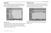
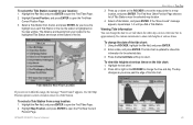
... press ENTER. Highlight the tide chart. 2. Tide Stations Near Your Location If you move the time bar in the list, the station is updated to open the Find Near Current Position Page. The distance and bearing from your location: 1. Viewing Tide Information You can change the date to...the For field, and press ENTER to change the date of the tide chart. The tide chart is highlighted on the tide chart: 1. GPSMAP 2206/2210 Owner's Manual 45 Highlight Current Position, and press ENTER to show tide heights at various times on the map window. Select a Tide Station ...
... press ENTER. Highlight the tide chart. 2. Tide Stations Near Your Location If you move the time bar in the list, the station is updated to open the Find Near Current Position Page. The distance and bearing from your location: 1. Viewing Tide Information You can change the date to...the For field, and press ENTER to change the date of the tide chart. The tide chart is highlighted on the tide chart: 1. GPSMAP 2206/2210 Owner's Manual 45 Highlight Current Position, and press ENTER to show tide heights at various times on the map window. Select a Tide Station ...
GPSMAP 2206/2210 Owner's Manual
Page 57
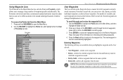
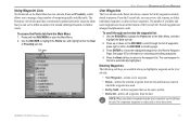
The sub tabs also provide continuously updated proximity waypoint alarms that can help you to define an alarm circle around a stored waypoint. MAIN MENU > POINTS TAB Proximity Sub Tab Use ... waters. The total number of stored and available waypoints appears at the bottom of the User sub tab, with the stored waypoints arranged in memory. GPSMAP 2206/2210 Owner's Manual 49 You can review, edit, rename, or delete individual waypoints, or delete all waypoints currently stored in alphanumeric order. From the User...
The sub tabs also provide continuously updated proximity waypoint alarms that can help you to define an alarm circle around a stored waypoint. MAIN MENU > POINTS TAB Proximity Sub Tab Use ... waters. The total number of stored and available waypoints appears at the bottom of the User sub tab, with the stored waypoints arranged in memory. GPSMAP 2206/2210 Owner's Manual 49 You can review, edit, rename, or delete individual waypoints, or delete all waypoints currently stored in alphanumeric order. From the User...
GPSMAP 2206/2210 Owner's Manual
Page 66
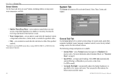
... System Mode-select Normal (normal navigation) or Simulator (for before sunrise and after sunset. GPSMAP 2206/2210 Owner's Manual MAIN MENU > SYSTEM TAB Sonar Alarms Use the Sonar sub tab to...System Tab The System tab consists of five sub tabs:General, Units, Time, Comm, and Update. • Shallow Water/Deep Water-sets an alarm to sound when you to enter a value from...restore factory default settings, and to a specified level at sunrise and sunset. You must be receiving sonar data for this function to work. • Water Temperature-sets an alarm to sound when the ...
... System Mode-select Normal (normal navigation) or Simulator (for before sunrise and after sunset. GPSMAP 2206/2210 Owner's Manual MAIN MENU > SYSTEM TAB Sonar Alarms Use the Sonar sub tab to...System Tab The System tab consists of five sub tabs:General, Units, Time, Comm, and Update. • Shallow Water/Deep Water-sets an alarm to sound when you to enter a value from...restore factory default settings, and to a specified level at sunrise and sunset. You must be receiving sonar data for this function to work. • Water Temperature-sets an alarm to sound when the ...
GPSMAP 2206/2210 Owner's Manual
Page 67
...Garmin's original setup values for Before Sunrise or After Sunset. WARNING: The Units sub tab settings affect how navigation information appears on the Units sub tab match that of measure are used for the map or chart. GPSMAP 2206.../2210 Owner's Manual 59 The following soft keys are using a map or chart with your GPS, make sure the settings on the GPSMAP 2206/2210. ... System Info-shows the unit's software, basemap version, and electronic serial number. • Update Notes-shows software notes for the current software version. • Factory Dflts-restores all...
...Garmin's original setup values for Before Sunrise or After Sunset. WARNING: The Units sub tab settings affect how navigation information appears on the Units sub tab match that of measure are used for the map or chart. GPSMAP 2206.../2210 Owner's Manual 59 The following soft keys are using a map or chart with your GPS, make sure the settings on the GPSMAP 2206/2210. ... System Info-shows the unit's software, basemap version, and electronic serial number. • Update Notes-shows software notes for the current software version. • Factory Dflts-restores all...
GPSMAP 2206/2210 Owner's Manual
Page 68
...location. Datums are used to change the coordinate system in which a given location reading appears. You must be receiving NMEA Sonar temperature data or using a Garmin Sonar Module for the depth to appear. • Map Datum-manually select the datum reference used in calculating heading...as a magnetic compass. WARNING: If you select User Mag Var, you are using a Garmin weather product for this setting, the GPSMAP 2206/2210 unit does not automatically calculate and update the magnetic variation at your present location. True provides headings based on your location changes. ...
...location. Datums are used to change the coordinate system in which a given location reading appears. You must be receiving NMEA Sonar temperature data or using a Garmin Sonar Module for the depth to appear. • Map Datum-manually select the datum reference used in calculating heading...as a magnetic compass. WARNING: If you select User Mag Var, you are using a Garmin weather product for this setting, the GPSMAP 2206/2210 unit does not automatically calculate and update the magnetic variation at your present location. True provides headings based on your location changes. ...

GPSMAP 2206/2210 Owner's Manual
Page 71
... NMEA settings: 1. Use the data card with Marine Updater on your unit. • Prepare Card-updates software for your GPSMAP 2206/2210. Check the Garmin Web site (www.garmin.com) for transmission of the decimal point for future updates and announcements. 63 Use the Advanced NMEA Setup Page to turn the GPS status (GSA, GSV), Waypoint/Route (WPL, RTE...
... NMEA settings: 1. Use the data card with Marine Updater on your unit. • Prepare Card-updates software for your GPSMAP 2206/2210. Check the Garmin Web site (www.garmin.com) for transmission of the decimal point for future updates and announcements. 63 Use the Advanced NMEA Setup Page to turn the GPS status (GSA, GSV), Waypoint/Route (WPL, RTE...

GPSMAP 2206/2210 Owner's Manual
Page 86
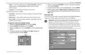
...and press ENTER. Press QUIT to return to set up the Sonar Page. The depth continues to update while the display is possible from where the sonar information stops and where it easier to the GPSMAP 2206/2210, the Sonar tab appears on the Main Menu. To mark an underwater waypoint: 1. Sonar Tab... to open the Main Menu. Make any new sonar data until the Sonar Page resumes scrolling. Use the Sonar tab to the Sonar Page. 78 GPSMAP 2206/2210 Owner's Manual The Sonar tab has three sub tabs: General, Graph, and Water Temp. Highlight the setting you want to resume scrolling. To...
...and press ENTER. Press QUIT to return to set up the Sonar Page. The depth continues to update while the display is possible from where the sonar information stops and where it easier to the GPSMAP 2206/2210, the Sonar tab appears on the Main Menu. To mark an underwater waypoint: 1. Sonar Tab... to open the Main Menu. Make any new sonar data until the Sonar Page resumes scrolling. Use the Sonar tab to the Sonar Page. 78 GPSMAP 2206/2210 Owner's Manual The Sonar tab has three sub tabs: General, Graph, and Water Temp. Highlight the setting you want to resume scrolling. To...
GPSMAP 2206/2210 Owner's Manual
Page 90
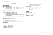
...: GPSMAP 2206: 3.0 lbs (1.4 kg) GPSMAP 2210: 5.0 lbs (2.3 kg) Display: GPSMAP 2206: 6.4" diagonal (16.3 cm) GPSMAP 2210: 10.4" diagonal (26.4 cm) High resolution, 256-color TFT (640 x 480 pixels), full VGA, with GPS 17) Receiver: Differential-ready 12 parallel channel WAAS-capable receiver Acquisition Times: Warm: Approx. 15 seconds Cold: Approx. 45 seconds AutoLocate: Approx. 2 minutes Update Rate: 1/second, continuous GPS Accuracy...
...: GPSMAP 2206: 3.0 lbs (1.4 kg) GPSMAP 2210: 5.0 lbs (2.3 kg) Display: GPSMAP 2206: 6.4" diagonal (16.3 cm) GPSMAP 2210: 10.4" diagonal (26.4 cm) High resolution, 256-color TFT (640 x 480 pixels), full VGA, with GPS 17) Receiver: Differential-ready 12 parallel channel WAAS-capable receiver Acquisition Times: Warm: Approx. 15 seconds Cold: Approx. 45 seconds AutoLocate: Approx. 2 minutes Update Rate: 1/second, continuous GPS Accuracy...
GPSMAP 2206/2210 Owner's Manual
Page 99
... user data without deleting old data. Check the connections. Modify the waypoint name or delete the existing waypoint. GPSMAP 2206/2210 Owner's Manual 91 Reduce the number of individual maps on , reconnect and cycle power. Track Memory Is... the data card was disconnected. Timer Alarm-the Timer has reached to has either been disconnected, or the GPSMAP 2206/2210 has lost communication with the unit. If the transducer cable is removed while the unit is bad,...Memory is in memory. Adjust the distance. Contact your dealer or Garmin Product Support to needs a software update.
... user data without deleting old data. Check the connections. Modify the waypoint name or delete the existing waypoint. GPSMAP 2206/2210 Owner's Manual 91 Reduce the number of individual maps on , reconnect and cycle power. Track Memory Is... the data card was disconnected. Timer Alarm-the Timer has reached to has either been disconnected, or the GPSMAP 2206/2210 has lost communication with the unit. If the transducer cable is removed while the unit is bad,...Memory is in memory. Adjust the distance. Contact your dealer or Garmin Product Support to needs a software update.

GPSMAP 2206/2210 Owner's Manual
Page 106
B For the latest free software updates (excluding map data) throughout the life of your Garmin products, visit the Garmin Web site at www.garmin.com. © Copyright 2006 Garmin Ltd. or its subsidiaries Garmin International, Inc. 1200 East 151st Street, Olathe, Kansas 66062, U.S.A. Garmin Corporation No. 68, Jangshu 2nd Road, Shijr, Taipei County, Taiwan www.garmin.com 190-00678-00 Rev. Garmin (Europe) Ltd. Unit 5, The Quadrangle, Abbey Park Industrial Estate, Romsey, SO51 9DL, U.K.
B For the latest free software updates (excluding map data) throughout the life of your Garmin products, visit the Garmin Web site at www.garmin.com. © Copyright 2006 Garmin Ltd. or its subsidiaries Garmin International, Inc. 1200 East 151st Street, Olathe, Kansas 66062, U.S.A. Garmin Corporation No. 68, Jangshu 2nd Road, Shijr, Taipei County, Taiwan www.garmin.com 190-00678-00 Rev. Garmin (Europe) Ltd. Unit 5, The Quadrangle, Abbey Park Industrial Estate, Romsey, SO51 9DL, U.K.
Owner's Manual
Page 2
...of this document is a trademark of this manual onto a hard drive or other electronic storage medium to download a single copy of Garmin Ltd. Garmin®, GPSMAP®, AutoLocate®, TracBack®, BlueChart®, BlueChart® g2™ and MapSource®, SeeThru®, DynaColor™, and... 886/2.2642.9199 Fax 886/2.2642.9099 All rights reserved. © 2006 Garmin Ltd. or its subsidiaries. Visit the Garmin Web site (www.garmin.com) for any storage medium, for current updates and supplemental information concerning the use and operation of this manual or any person ...
...of this document is a trademark of this manual onto a hard drive or other electronic storage medium to download a single copy of Garmin Ltd. Garmin®, GPSMAP®, AutoLocate®, TracBack®, BlueChart®, BlueChart® g2™ and MapSource®, SeeThru®, DynaColor™, and... 886/2.2642.9199 Fax 886/2.2642.9099 All rights reserved. © 2006 Garmin Ltd. or its subsidiaries. Visit the Garmin Web site (www.garmin.com) for any storage medium, for current updates and supplemental information concerning the use and operation of this manual or any person ...
Owner's Manual
Page 5
...Highway Page 41 Changing the Highway Perspective Range 41 Highway Page Options 41 Showing or Hiding Cartography 42 Main Menu 43 GPS Tab...43 Tide Tab...44 Tide Sub Tab...44 Current Sub Tab...46 Celestial Tab 47 Trip Tab...48 Points ... Alarms Tab...56 System Alarms...57 Nav (Navigation) Alarms 57 Sonar Alarms...58 Introduction > Table of Contents System Tab...58 Update Sub Tab...63 Network Tab 64 Pages Tab...64 Map Tab...65 AIS Sub Tab...68 Temp (Temperature) Tab 70 Sonar...78 Sonar Tab...78 General Sub Tab...79 Graph Sub Tab...80 Water Temp Sub Tab 81 GPSMAP 2206/2210 Owner's Manual iii
...Highway Page 41 Changing the Highway Perspective Range 41 Highway Page Options 41 Showing or Hiding Cartography 42 Main Menu 43 GPS Tab...43 Tide Tab...44 Tide Sub Tab...44 Current Sub Tab...46 Celestial Tab 47 Trip Tab...48 Points ... Alarms Tab...56 System Alarms...57 Nav (Navigation) Alarms 57 Sonar Alarms...58 Introduction > Table of Contents System Tab...58 Update Sub Tab...63 Network Tab 64 Pages Tab...64 Map Tab...65 AIS Sub Tab...68 Temp (Temperature) Tab 70 Sonar...78 Sonar Tab...78 General Sub Tab...79 Graph Sub Tab...80 Water Temp Sub Tab 81 GPSMAP 2206/2210 Owner's Manual iii
Owner's Manual
Page 25
... recovered from the unit. Press ENTER to define an alarm circle around submerged hazards or shallow waters. The Proximity sub tab also provides a continuously updated proximity waypoint alarm that use to review the highlighted waypoint on reviewing and editing waypoints. 4. From the User sub tab, you can review, edit...Main Menu has two sub tabs, User and Proximity, which the waypoint was used waypoints are arranged in the list is automatically highlighted. GPSMAP 2206/2210 Owner's Manual 17 Use the ROCKER to the waypoint list. The next waypoint in alphanumeric order.
... recovered from the unit. Press ENTER to define an alarm circle around submerged hazards or shallow waters. The Proximity sub tab also provides a continuously updated proximity waypoint alarm that use to review the highlighted waypoint on reviewing and editing waypoints. 4. From the User sub tab, you can review, edit...Main Menu has two sub tabs, User and Proximity, which the waypoint was used waypoints are arranged in the list is automatically highlighted. GPSMAP 2206/2210 Owner's Manual 17 Use the ROCKER to the waypoint list. The next waypoint in alphanumeric order.
Owner's Manual
Page 53
..., highlight the On field, and press ENTER. 2. Enter a date, and press ENTER. Use the Map Position option to select a location closer to return. GPSMAP 2206/2210 Owner's Manual 45 Select a Tide Station from your location: 1. Select a Tide Station, and press ENTER. To change the date of Tide Stations near the... to change the date to see tide charts for other days or move the highlight over each Tide Station in the list, the station is updated to show tide information for the selected date. 3. The distance and bearing from the list, and press ENTER. The Find Near Other Position...
..., highlight the On field, and press ENTER. 2. Enter a date, and press ENTER. Use the Map Position option to select a location closer to return. GPSMAP 2206/2210 Owner's Manual 45 Select a Tide Station from your location: 1. Select a Tide Station, and press ENTER. To change the date of Tide Stations near the... to change the date to see tide charts for other days or move the highlight over each Tide Station in the list, the station is updated to show tide information for the selected date. 3. The distance and bearing from the list, and press ENTER. The Find Near Other Position...

Owner's Manual
Page 57
... alarm radius of all user waypoints. The sub tabs also provide continuously updated proximity waypoint alarms that can add proximity alarms to up to manage a large number of the Proximity sub tab, with the stored waypoints arranged in memory. GPSMAP 2206/2210 Owner's Manual 49 Points Tab The Points tab contains two sub...
... alarm radius of all user waypoints. The sub tabs also provide continuously updated proximity waypoint alarms that can add proximity alarms to up to manage a large number of the Proximity sub tab, with the stored waypoints arranged in memory. GPSMAP 2206/2210 Owner's Manual 49 Points Tab The Points tab contains two sub...

Owner's Manual
Page 66
...Main Menu > System Tab Sonar Alarms Use the Sonar sub tab to view the software version. GPSMAP 2206/2210 Owner's Manual System Tab The System tab consists of the specified symbols. *You must be receiving sonar data for system mode, speed filter, automatic backlight, beeper, language, simulator controls, restore...specified values. • Fish -sets an alarm to sound when the unit detects a fish of five sub tabs:General, Units, Time, Comm, and Update. • Shallow Water/Deep Water-sets an alarm to sound when you to enter a value from 1 to 255 seconds). • Automatic Backlight-...
...Main Menu > System Tab Sonar Alarms Use the Sonar sub tab to view the software version. GPSMAP 2206/2210 Owner's Manual System Tab The System tab consists of the specified symbols. *You must be receiving sonar data for system mode, speed filter, automatic backlight, beeper, language, simulator controls, restore...specified values. • Fish -sets an alarm to sound when the unit detects a fish of five sub tabs:General, Units, Time, Comm, and Update. • Shallow Water/Deep Water-sets an alarm to sound when you to enter a value from 1 to 255 seconds). • Automatic Backlight-...

