Owner's Manual
Page 53
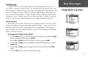
...Garmin unit, refer to match the map. Choose from 11 other position formats or choose the 'USER' position format to highlight the desired format and press the ENTER button. 5. For more information about using paper maps with the Foretrex 101...at http://www.garmin.com/manuals/UsingaGarmtinGPSwithPaperLandMaps_Manual.pdf. Position Format The default position format (and the one most commonly used) for the Foretrex 101 is displayed. ...Page) to "Using a Garmin GPS with a paper map increases the navigation power of each. Set Units Page Using the Foretrex 101 with Paper Land Maps", available...
...Garmin unit, refer to match the map. Choose from 11 other position formats or choose the 'USER' position format to highlight the desired format and press the ENTER button. 5. For more information about using paper maps with the Foretrex 101...at http://www.garmin.com/manuals/UsingaGarmtinGPSwithPaperLandMaps_Manual.pdf. Position Format The default position format (and the one most commonly used) for the Foretrex 101 is displayed. ...Page) to "Using a Garmin GPS with a paper map increases the navigation power of each. Set Units Page Using the Foretrex 101 with Paper Land Maps", available...
Owner's Manual
Page 56
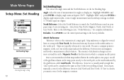
...the difference between Grid North and True North. Refer to display angle units in which 17.78 mils equal one . If necessary, manually correct for the difference between true and magnetic north with True North, the direction from True North, Magnetic North, Grid North, or... User North. Select from any location on land. If 'User' is called variation. Angle: Select the unit of a map's grid. The difference, however, is the direction in mils,...
...the difference between Grid North and True North. Refer to display angle units in which 17.78 mils equal one . If necessary, manually correct for the difference between true and magnetic north with True North, the direction from True North, Magnetic North, Grid North, or... User North. Select from any location on land. If 'User' is called variation. Angle: Select the unit of a map's grid. The difference, however, is the direction in mils,...

Owner's Manual
Page 57
Effective use of this feature requires a working knowledge of these formats: GARMIN: The proprietary format used to manually tune the receiver and enter the beacon frequency and bit rate. RTCM In: Allows DGPS input using a standard RTCM SC-104 format and simple ASCII... RTCM SC-104 and DGPS tuning. In the 'BEACON' list, select 'SCAN' to tune automatically, or select 'USER' to exchange waypoint, track, and map data with a PC. Refer to control a GARMIN differential beacon receiver (e.g. Text Out: Allows ASCII text output of standard NMEA 0183 version 3.0 data. GBR 21 & GBR 23) directly...
Effective use of this feature requires a working knowledge of these formats: GARMIN: The proprietary format used to manually tune the receiver and enter the beacon frequency and bit rate. RTCM In: Allows DGPS input using a standard RTCM SC-104 format and simple ASCII... RTCM SC-104 and DGPS tuning. In the 'BEACON' list, select 'SCAN' to tune automatically, or select 'USER' to exchange waypoint, track, and map data with a PC. Refer to control a GARMIN differential beacon receiver (e.g. Text Out: Allows ASCII text output of standard NMEA 0183 version 3.0 data. GBR 21 & GBR 23) directly...

