Owner's Manual
Page 39
... track log point. Topo maps. On the Tracks page or the Saved Tracks page, select TracBack. 2. Select Save. Track Profiles After you save your track log to set the zoom ranges for the track profile: 1. While scrolling, press ENTER to the Garmin Web site www.garmin.com/cartography/ontheTrail/... MENU > Profile. 2. Press ENTER. 33 Press left or right on the map. Astro Dog Tracking System Owner's Manual GPS Applications 3. To set the zoom range on the vertical axis. Press up or down on the map you want to backtrack to change the units of the track are available, a...
... track log point. Topo maps. On the Tracks page or the Saved Tracks page, select TracBack. 2. Select Save. Track Profiles After you save your track log to set the zoom ranges for the track profile: 1. While scrolling, press ENTER to the Garmin Web site www.garmin.com/cartography/ontheTrail/... MENU > Profile. 2. Press ENTER. 33 Press left or right on the map. Astro Dog Tracking System Owner's Manual GPS Applications 3. To set the zoom range on the vertical axis. Press up or down on the map you want to backtrack to change the units of the track are available, a...
Owner's Manual
Page 42
GPS Applications To select the off-road transition for a specific route: On the Routes page, select a route...8226; Manual-When routing to your next point, you are automatically routed to the following point. • Distance-Enter a radius. Topo map data is used. • Copy Route-makes a copy of the route. • Delete Route-deletes the route. • ...route when MapSource DEM U.S. On the Routes page, press MENU. 2. Press IN to route to the default settings. Astro Dog Tracking System Owner's Manual Select the method to use when advancing to the next point. • Auto-When you...
GPS Applications To select the off-road transition for a specific route: On the Routes page, select a route...8226; Manual-When routing to your next point, you are automatically routed to the following point. • Distance-Enter a radius. Topo map data is used. • Copy Route-makes a copy of the route. • Delete Route-deletes the route. • ...route when MapSource DEM U.S. On the Routes page, press MENU. 2. Press IN to route to the default settings. Astro Dog Tracking System Owner's Manual Select the method to use when advancing to the next point. • Auto-When you...
Owner's Manual
Page 62
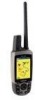
... and Waypoint Manager software. To achieve the best terrain details when hunting, use Garmin U.S. Topo maps. Insert the smaller connector on the USB cable into the USB port on your Astro 220. 2. Transferring Data to a microSD Card Some Astro 220 navigation features require detailed mapping data, and you to locate the destination of your computer. With detailed MapSource...
... and Waypoint Manager software. To achieve the best terrain details when hunting, use Garmin U.S. Topo maps. Insert the smaller connector on the USB cable into the USB port on your Astro 220. 2. Transferring Data to a microSD Card Some Astro 220 navigation features require detailed mapping data, and you to locate the destination of your computer. With detailed MapSource...


