User Guide
Page 1
... the two-prong end of the unit in the literature accompanying the appliance. CAUTION: These servicing instructions are qualified to rain or moisture. 1 To reduce the risk of electric to service manual for a long time, disconnect the plug from the outlet. To reduce the risk of important operating and maintenance (servicing) instructions in the USB port. Refer to persons. WARNING: TO...
... the two-prong end of the unit in the literature accompanying the appliance. CAUTION: These servicing instructions are qualified to rain or moisture. 1 To reduce the risk of electric to service manual for a long time, disconnect the plug from the outlet. To reduce the risk of important operating and maintenance (servicing) instructions in the USB port. Refer to persons. WARNING: TO...
User Guide
Page 6
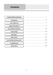
Contents Important Safety Instructions Accessories View of Main Unit System Connections Power Supply Preparation General Setup MP3 Player Photo Viewer Use of the Mount Accessories Troubleshooting Specifications 1 5 7 8 10 12 16 18 20 21 23 6
Contents Important Safety Instructions Accessories View of Main Unit System Connections Power Supply Preparation General Setup MP3 Player Photo Viewer Use of the Mount Accessories Troubleshooting Specifications 1 5 7 8 10 12 16 18 20 21 23 6
User Manual
Page 2
... menu 20 2.4.3 Daytime and night color profiles 20 2.4.4 Color scheme in tunnels 21 2.4.5 Route calculation and recalculation 21 2.4.6 Itinerary ...22 2.4.7 Track Logs ...23 2.4.8 Route demonstration 23 2.4.9 POI (Points of Interest 23 2.4.10 Speed limit warning 24 3 Navigating with Nextar Navigation System 25 3.1 Selecting the destination of a route 25 3.1.1 Selecting the Cursor as the destination 25 3.1.2 Entering an address or part of an address 26 3.1.2.1 Entering an address 26 3.1.2.2 Entering an address if house numbering...
... menu 20 2.4.3 Daytime and night color profiles 20 2.4.4 Color scheme in tunnels 21 2.4.5 Route calculation and recalculation 21 2.4.6 Itinerary ...22 2.4.7 Track Logs ...23 2.4.8 Route demonstration 23 2.4.9 POI (Points of Interest 23 2.4.10 Speed limit warning 24 3 Navigating with Nextar Navigation System 25 3.1 Selecting the destination of a route 25 3.1.1 Selecting the Cursor as the destination 25 3.1.2 Entering an address or part of an address 26 3.1.2.1 Entering an address 26 3.1.2.2 Entering an address if house numbering...
User Manual
Page 3
... 3.1.7 Selecting the destination by entering its coordinates 36 3.2 Creating a multi-point route (inserting a via point 36 3.3 Creating a multi-point route (appending a new destination 37 3.4 Editing the route 37 3.5 Viewing the entire route on the map (Fit-to-Screen 38 3.6 Watching the simulation of the route 38 3.7 Enabling Safety Mode 39 3.8 Pausing the active route 39 3.9 Deleting the next via point from the route 39 3.10 Deleting the active route 40 3.11 Using Track Logs 40 3.12 Saving a route 41 3.13 Loading a saved route 41 4 MSN Direct 43 4.1 Starting MSN Direct 43...
... 3.1.7 Selecting the destination by entering its coordinates 36 3.2 Creating a multi-point route (inserting a via point 36 3.3 Creating a multi-point route (appending a new destination 37 3.4 Editing the route 37 3.5 Viewing the entire route on the map (Fit-to-Screen 38 3.6 Watching the simulation of the route 38 3.7 Enabling Safety Mode 39 3.8 Pausing the active route 39 3.9 Deleting the next via point from the route 39 3.10 Deleting the active route 40 3.11 Using Track Logs 40 3.12 Saving a route 41 3.13 Loading a saved route 41 4 MSN Direct 43 4.1 Starting MSN Direct 43...
User Manual
Page 5
... in GPS receiver. Plan the route before you start your journey. Never place Nextar Q4-MD where it obstructs the driver's view, where it is in the deployment zone of 10 km/h (6 mph) or higher. Unless only passengers operate Nextar Navigation System, we recommend that Nextar Navigation System recommended, Nextar Navigation System changes the instructions accordingly. 1 Warnings and Safety information Nextar Navigation System is a navigation system that helps you find your way to turn...
... in GPS receiver. Plan the route before you start your journey. Never place Nextar Q4-MD where it obstructs the driver's view, where it is in the deployment zone of 10 km/h (6 mph) or higher. Unless only passengers operate Nextar Navigation System, we recommend that Nextar Navigation System recommended, Nextar Navigation System changes the instructions accordingly. 1 Warnings and Safety information Nextar Navigation System is a navigation system that helps you find your way to turn...
User Manual
Page 7
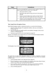
Select the written language of two intersecting streets (page 26). • Enter an address with ZIP code (page 32). After this, the Navigation menu appears and you can change it in Settings (page 76). 2. You can change it in Settings (page 76). 3. Later you need gestures to select a destination, and start navigating. The Navigation menu in Simple mode: The Navigation menu in Advanced mode: The typical way of using Nextar Navigation System is started the first time, you can...
Select the written language of two intersecting streets (page 26). • Enter an address with ZIP code (page 32). After this, the Navigation menu appears and you can change it in Settings (page 76). 2. You can change it in Settings (page 76). 3. Later you need gestures to select a destination, and start navigating. The Navigation menu in Simple mode: The Navigation menu in Advanced mode: The typical way of using Nextar Navigation System is started the first time, you can...
User Manual
Page 8
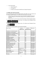
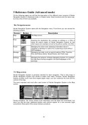
... of Nextar Navigation System. To switch from Simple mode to the most important navigation functions and the basic settings only. The features and settings available in Explanation Advanced mode Navigating to a selected map point Yes Yes Navigating to a street address Navigating to an incomplete address Navigating to an intersection Navigating to recent destinations (History) Navigating to Favorites Navigating to a POI Navigating to coordinates Creating a multi-point route Saving a map point as a Favorite destination Saving a map point as follows: Type of available features.
... of Nextar Navigation System. To switch from Simple mode to the most important navigation functions and the basic settings only. The features and settings available in Explanation Advanced mode Navigating to a selected map point Yes Yes Navigating to a street address Navigating to an incomplete address Navigating to an intersection Navigating to recent destinations (History) Navigating to Favorites Navigating to a POI Navigating to coordinates Creating a multi-point route Saving a map point as a Favorite destination Saving a map point as follows: Type of available features.
User Manual
Page 17
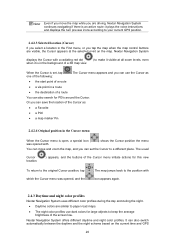
... the road in front of you. • While driving without an active route in Nextar Navigation System: Smart Zoom will zoom in Advanced mode only) Saves the Cursor as a Favorite location Marks the map with the name, address and coordinate information of the Cursor, and the list of the following options: • Use the Find menu to let you drive at high speed. 18 If the next turn...
... the road in front of you. • While driving without an active route in Nextar Navigation System: Smart Zoom will zoom in Advanced mode only) Saves the Cursor as a Favorite location Marks the map with the name, address and coordinate information of the Cursor, and the list of the following options: • Use the Find menu to let you drive at high speed. 18 If the next turn...
User Manual
Page 19
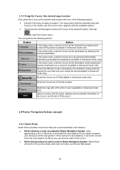
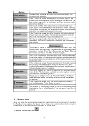
... Cursor menu initiate actions for this new To return to your current GPS position. 2.4.2.3 Selected location (Cursor) If you select a location in the Find menu, or you are visible, the Cursor appears at all zoom levels, even when it visible at the selected point on the current time and GPS 20 The usual Cursor ( location. ) appears, and the buttons of a route You can use dark colors for POIs around...
... Cursor menu initiate actions for this new To return to your current GPS position. 2.4.2.3 Selected location (Cursor) If you select a location in the Find menu, or you are visible, the Cursor appears at all zoom levels, even when it visible at the selected point on the current time and GPS 20 The usual Cursor ( location. ) appears, and the buttons of a route You can use dark colors for POIs around...
User Manual
Page 22
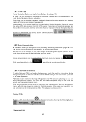
... native GPS data received from a simulation at high speed or at the desired location, then tap the following the driving instructions (page 38). To turn on the map, exported to take that someone might find useful or interesting. The icons are also semi-transparent: they cannot be started from the Route menu by tapping the (high speed simulation) or the (simulation at normal speed) button. 2.4.9 POI (Points of Interest) A point of interest (POI...
... native GPS data received from a simulation at high speed or at the desired location, then tap the following the driving instructions (page 38). To turn on the map, exported to take that someone might find useful or interesting. The icons are also semi-transparent: they cannot be started from the Route menu by tapping the (high speed simulation) or the (simulation at normal speed) button. 2.4.9 POI (Points of Interest) A point of interest (POI...
User Manual
Page 42
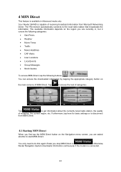
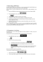
... information. 4 MSN Direct This feature is available in . Your Nextar Q4-MD is connected. 43 Otherwise, Nextar Navigation System downloads information continuously if the modem is capable of MSN Direct. You can access the downloaded information by tapping the appropriate category button on the main screens of receiving broadcast information from MSN Direct. 4.1 Starting MSN Direct When you first tap the MSN Direct button on the region you stop MSN Direct in Advanced mode only. The available information...
... information. 4 MSN Direct This feature is available in . Your Nextar Q4-MD is connected. 43 Otherwise, Nextar Navigation System downloads information continuously if the modem is capable of MSN Direct. You can access the downloaded information by tapping the appropriate category button on the main screens of receiving broadcast information from MSN Direct. 4.1 Starting MSN Direct When you first tap the MSN Direct button on the region you stop MSN Direct in Advanced mode only. The available information...
User Manual
Page 43
... MSN Direct system broadcasts your code, Nextar Navigation System starts downloading information from the Navigation menu. 1. Tap the following buttons: , . 2. If you are looking for, tap . • To set up the price range you can fine-tune the price rating: • To change the type of gas stations will be done on the screen. 5. Insert your MSN Direct modem between your Nextar Q4-MD. 2. From the Navigation menu, select . 3. You need a subscription...
... MSN Direct system broadcasts your code, Nextar Navigation System starts downloading information from the Navigation menu. 1. Tap the following buttons: , . 2. If you are looking for, tap . • To set up the price range you can fine-tune the price rating: • To change the type of gas stations will be done on the screen. 5. Insert your MSN Direct modem between your Nextar Q4-MD. 2. From the Navigation menu, select . 3. You need a subscription...
User Manual
Page 50
... paper road maps. Managing the behavior of Nextar Navigation System, for example the map layout during navigation, the used screen of Nextar Navigation System is why maps in Advanced mode. Most parts of the screen behave as saved locations (POIs, Favorites, Pins, and History items), Saved Routes, and Track Logs. Managing user data, such as buttons. 51 During navigation, the screen shows route information and trip data (left screenshot), but only a few seconds (right screenshot). Managing the active route (obtaining information about it, changing or deleting...
... paper road maps. Managing the behavior of Nextar Navigation System, for example the map layout during navigation, the used screen of Nextar Navigation System is why maps in Advanced mode. Most parts of the screen behave as saved locations (POIs, Favorites, Pins, and History items), Saved Routes, and Track Logs. Managing user data, such as buttons. 51 During navigation, the screen shows route information and trip data (left screenshot), but only a few seconds (right screenshot). Managing the active route (obtaining information about it, changing or deleting...
User Manual
Page 59
... start point from the route. The Cursor is near the destination, this button replaces the previous one , and deletes the selected via point. Select the POI group and give a name for the POI, then select a suitable icon, enter a phone number, and additional information if you decide where the new via points, this button replaces the previous one , and deletes the current destination from another on the map (the Cursor is the current GPS position), the Position menu replaces the Cursor menu. Map locations...
... start point from the route. The Cursor is near the destination, this button replaces the previous one , and deletes the selected via point. Select the POI group and give a name for the POI, then select a suitable icon, enter a phone number, and additional information if you decide where the new via points, this button replaces the previous one , and deletes the current destination from another on the map (the Cursor is the current GPS position), the Position menu replaces the Cursor menu. Map locations...
User Manual
Page 66
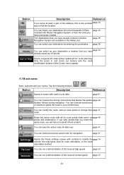
... 35 You can select as your destination a location that you need the same route, you have to modify the page 74 vehicle, the road types used for later use. Opens a special 2D map screen optimized for navigation. Only the Zoom in the History list. You can run a demonstration of the route at normal speed. Button Description Reference If you know at least a part of the address, this is the...
... 35 You can select as your destination a location that you need the same route, you have to modify the page 74 vehicle, the road types used for later use. Opens a special 2D map screen optimized for navigation. Only the Zoom in the History list. You can run a demonstration of the route at normal speed. Button Description Reference If you know at least a part of the address, this is the...
User Manual
Page 75
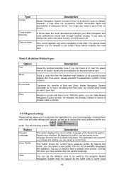
... lanes Description Nextar Navigation System includes ferries in a planned route by the program. You should check whether you are allowed to be used by default. you are asked to choose the voice guidance profile you have selected the new spoken language. Nextar Navigation System may not support all the listed units in some cases the route calculated according to your local language, measurement units, time and date settings and formats, as...
... lanes Description Nextar Navigation System includes ferries in a planned route by the program. You should check whether you are allowed to be used by default. you are asked to choose the voice guidance profile you have selected the new spoken language. Nextar Navigation System may not support all the listed units in some cases the route calculated according to your local language, measurement units, time and date settings and formats, as...
User Manual
Page 76
.... The current time of the GPS receiver and the device clock are available. The position shown on Road This feature allows car drivers to always correct GPS position errors by matching the vehicle position to check whether any correction is needed. 5.5.5 Navigation settings You can also help you select a measurement unit not supported by the GPS receiver. This allows you deviate from it. Tap the following buttons: , , . Off-route Recalculation This switch tells Nextar Navigation System whether...
.... The current time of the GPS receiver and the device clock are available. The position shown on Road This feature allows car drivers to always correct GPS position errors by matching the vehicle position to check whether any correction is needed. 5.5.5 Navigation settings You can also help you select a measurement unit not supported by the GPS receiver. This allows you deviate from it. Tap the following buttons: , , . Off-route Recalculation This switch tells Nextar Navigation System whether...
User Manual
Page 80
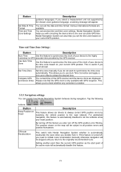
... active at least four signals to give you elevation data: only 2D reception is possible. 6 Glossary 2D/3D GPS reception The GPS receiver uses satellite signals to calculate its top always faces North. In 3D mode, you can block the signals, your real position and the one route can calculate your destination or you delete it is usually the most important intersection; In GPS-supported navigation, digital maps...
... active at least four signals to give you elevation data: only 2D reception is possible. 6 Glossary 2D/3D GPS reception The GPS receiver uses satellite signals to calculate its top always faces North. In 3D mode, you can block the signals, your real position and the one route can calculate your destination or you delete it is usually the most important intersection; In GPS-supported navigation, digital maps...
User Manual
Page 82
... with specific reference to the Act No. 4 of 1959 on the Civil Code (CC) and to Act No 76 of 1999 on Copyrights (CA). 3.2 This agreement is (are , on a computer, install in a vehicle or utilize in any medium thereof shall be deemed as part of the Software Product. 4.4 Error corrections, additions, updates used by the User as part of the Software Product. 5 Owner...
... with specific reference to the Act No. 4 of 1959 on the Civil Code (CC) and to Act No 76 of 1999 on Copyrights (CA). 3.2 This agreement is (are , on a computer, install in a vehicle or utilize in any medium thereof shall be deemed as part of the Software Product. 4.4 Error corrections, additions, updates used by the User as part of the Software Product. 5 Owner...
User Manual
Page 83
... to install the Software Product on one hardware device (desktop, handheld, portable computer, navigation device) at a time, and to run and use one security copy of the Software Product. software or hardware). 8.5 The Licensor shall hereby also draw the attention of the User with respect to make one copy thereof. 6.2 The User is entitled to make a copy thereof); 7.1.2 to lease, rent, lend, distribute, transfer it...
... to install the Software Product on one hardware device (desktop, handheld, portable computer, navigation device) at a time, and to run and use one security copy of the Software Product. software or hardware). 8.5 The Licensor shall hereby also draw the attention of the User with respect to make one copy thereof. 6.2 The User is entitled to make a copy thereof); 7.1.2 to lease, rent, lend, distribute, transfer it...


