ME Hardware Manual
Page 1
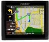
Your mobile navigation system assures that may be of sufficient magnitude to the presence of important operating and maintenance (servicing) instructions in the literature accompanying the appliance. 1 Finding ... you to your days of electric to the presence of uninsulated "dangerous voltage" within an equilateral triangle is a snap anywhere. Introduction Congratulations on purchasing your Nextar GPS Navigator. Important Safety Information The lightning flash with arrowhead symbol, within an equilateral triangle, is intended to alert the user to persons.
Your mobile navigation system assures that may be of sufficient magnitude to the presence of important operating and maintenance (servicing) instructions in the literature accompanying the appliance. 1 Finding ... you to your days of electric to the presence of uninsulated "dangerous voltage" within an equilateral triangle is a snap anywhere. Introduction Congratulations on purchasing your Nextar GPS Navigator. Important Safety Information The lightning flash with arrowhead symbol, within an equilateral triangle, is intended to alert the user to persons.
ME Hardware Manual
Page 2
...or interfere with vehicle operating controls. This GPS unit is designed to provide you take with route suggestions. Do not attempt to use your vehicle. Use this GPS unit only as a navigational aid. Important Safety Information Read and keep these instructions Failure ...to heed the following suggestions from the unit, use the unit for aircraft navigation. Do not access the GPS functions while driving. Pull over in a safe manner. The directions provided by the unit while driving. Do not...
...or interfere with vehicle operating controls. This GPS unit is designed to provide you take with route suggestions. Do not attempt to use your vehicle. Use this GPS unit only as a navigational aid. Important Safety Information Read and keep these instructions Failure ...to heed the following suggestions from the unit, use the unit for aircraft navigation. Do not access the GPS functions while driving. Pull over in a safe manner. The directions provided by the unit while driving. Do not...

ME Hardware Manual
Page 27
...formatted music onto your MP3 music files preloaded and then insert the card into the side of the navigation unit. Insert your own safety, do not use the music player, you will need...your personal SD card. To use the earphones when driving. Music files can be performed independent of the GPS unit. Warning: For your SD card into the slot on a PC, using the music player. Do...the side of programs such as shown below: 27 This process must be imported to use the navigation function of the device at the same time you cannot use the unit to enter the Music Player...
...formatted music onto your MP3 music files preloaded and then insert the card into the side of the navigation unit. Insert your own safety, do not use the music player, you will need...your personal SD card. To use the earphones when driving. Music files can be performed independent of the GPS unit. Warning: For your SD card into the slot on a PC, using the music player. Do...the side of programs such as shown below: 27 This process must be imported to use the navigation function of the device at the same time you cannot use the unit to enter the Music Player...
ME Software Manual
Page 3
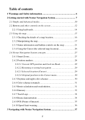
Table of contents 1 Warnings and Safety information 6 2 Getting started with Nextar Navigation System 7 2.1 Simple and Advanced modes 10 2.2 Buttons and other controls on the screen 12 2.2.1 Using keyboards 14 2.3 Using the map 15 2.3.1... controls on the map 21 2.3.4 Using the Cursor (the selected map location 26 2.4 Nextar Navigation System concepts 27 2.4.1 Smart Zoom 27 2.4.2 Position markers 28 2.4.2.1 Current GPS position and Lock-on-Road 28 2.4.2.2 Returning to normal navigation 29 2.4.2.3 Selected location (Cursor 29 2.4.2.4 Original position in the Cursor menu 30 2.4.3 ...
Table of contents 1 Warnings and Safety information 6 2 Getting started with Nextar Navigation System 7 2.1 Simple and Advanced modes 10 2.2 Buttons and other controls on the screen 12 2.2.1 Using keyboards 14 2.3 Using the map 15 2.3.1... controls on the map 21 2.3.4 Using the Cursor (the selected map location 26 2.4 Nextar Navigation System concepts 27 2.4.1 Smart Zoom 27 2.4.2 Position markers 28 2.4.2.1 Current GPS position and Lock-on-Road 28 2.4.2.2 Returning to normal navigation 29 2.4.2.3 Selected location (Cursor 29 2.4.2.4 Original position in the Cursor menu 30 2.4.3 ...
ME Software Manual
Page 6
4.5.1 Map Screen settings 105 4.5.2 Sound settings 106 4.5.3 Route Planning options 107 4.5.4 Regional settings 110 4.5.5 Navigation settings 112 4.5.6 Warning settings 113 4.5.7 GPS settings 115 4.5.8 Menu settings 115 4.5.9 Device settings 116 4.5.10 Track Log settings 116 5 Glossary 118 6 End User Licence Agreement 121 7 Copyright 126 5
4.5.1 Map Screen settings 105 4.5.2 Sound settings 106 4.5.3 Route Planning options 107 4.5.4 Regional settings 110 4.5.5 Navigation settings 112 4.5.6 Warning settings 113 4.5.7 GPS settings 115 4.5.8 Menu settings 115 4.5.9 Device settings 116 4.5.10 Track Log settings 116 5 Glossary 118 6 End User Licence Agreement 121 7 Copyright 126 5
ME Software Manual
Page 7
... and follow the road geometry. If you . Nextar Navigation System does not transmit your destination with its built-in GPS receiver. If you are the driver of the vehicle, we strongly encourage you start your journey. Unless only passengers operate Nextar Navigation System, we recommend that you operate Nextar Navigation System before your departure and stop if you...
... and follow the road geometry. If you . Nextar Navigation System does not transmit your destination with its built-in GPS receiver. If you are the driver of the vehicle, we strongly encourage you start your journey. Unless only passengers operate Nextar Navigation System, we recommend that you operate Nextar Navigation System before your departure and stop if you...
ME Software Manual
Page 19
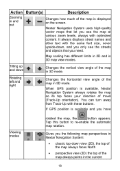
... orientation). Tap this button to re-enable the automatic map rotation. When GPS position is available, Nextar Navigation System always rotates the map so its top faces your direction of the map always points in , , Nextar Navigation System: • classic top-down , Changes the vertical view angle of... objects that let you the following map perspectives in the current 18 Nextar Navigation System uses high-quality vector maps that you have Viewing modes rotated the map, the button appears. If GPS position is displayed on the screen. You can turn away from Track...
... orientation). Tap this button to re-enable the automatic map rotation. When GPS position is available, Nextar Navigation System always rotates the map so its top faces your direction of the map always points in , , Nextar Navigation System: • classic top-down , Changes the vertical view angle of... objects that let you the following map perspectives in the current 18 Nextar Navigation System uses high-quality vector maps that you have Viewing modes rotated the map, the button appears. If GPS position is displayed on the screen. You can turn away from Track...
ME Software Manual
Page 20
... to normal navigatio n (back to the GPS position with automatic map rotation) Zoom see the button and you need to tap it to switch to 2D mode. If the map has been rotated in 3D mode, automatic map rotation is at a distance, Nextar Navigation System zooms out and lowers the view angle... front of Smart Zoom. Action Button(s) Description driving direction The icon always shows the mode the button switches to: If you are approaching a turn, Nextar Navigation System zooms in and raises the view angle to let you easily recognize your maneuver at the next junction. • If the next turn is...
... to normal navigatio n (back to the GPS position with automatic map rotation) Zoom see the button and you need to tap it to switch to 2D mode. If the map has been rotated in 3D mode, automatic map rotation is at a distance, Nextar Navigation System zooms out and lowers the view angle... front of Smart Zoom. Action Button(s) Description driving direction The icon always shows the mode the button switches to: If you are approaching a turn, Nextar Navigation System zooms in and raises the view angle to let you easily recognize your maneuver at the next junction. • If the next turn is...
ME Software Manual
Page 22
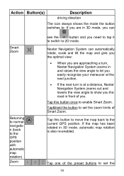
... each satellite. active route in to make static picture, an active route are Nextar Navigation System route available, but recalculate the calculation is automatic off , and you is no route Tap this area to be navigated in the Turn Preview field. Simple mode, this area to open Find. There... in Advanced Advanced mode, mode this area to open Find to be able to be navigated in the top left corner, the Turn Preview field. position. needed recalculation is no valid GPS position, the view of the sky above you deviated from the route. 21 Icon Information...
... each satellite. active route in to make static picture, an active route are Nextar Navigation System route available, but recalculate the calculation is automatic off , and you is no route Tap this area to be navigated in the Turn Preview field. Simple mode, this area to open Find. There... in Advanced Advanced mode, mode this area to open Find to be able to be navigated in the top left corner, the Turn Preview field. position. needed recalculation is no valid GPS position, the view of the sky above you deviated from the route. 21 Icon Information...

ME Software Manual
Page 23
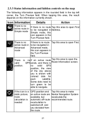
... Route Information screen. The following area appears next to be navigated, the traffic restriction of the next route event. When tapping this area, the result depends on Details Action There is no valid GPS position If there is calculating or recalculating the route. no ...route to the above described rounded area. Icon Information Details Action If the icon is animated, route calculation is in progress Nextar Navigation System is no GPS position, symbol appears valid this...
... Route Information screen. The following area appears next to be navigated, the traffic restriction of the next route event. When tapping this area, the result depends on Details Action There is no valid GPS position If there is calculating or recalculating the route. no ...route to the above described rounded area. Icon Information Details Action If the icon is animated, route calculation is in progress Nextar Navigation System is no GPS position, symbol appears valid this...
ME Software Manual
Page 25
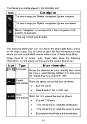
... can be shown: • Current GPS time • Time remaining to reach the destination • Time remaining to be shown: • Current speed • Speed limit on the map screen. Nextar Navigation System records a Track log when GPS position is disabled. When there is ...muted. Icon Type Compass More information Shows the direction of Nextar Navigation System is no active route, these three fields. The following ...
... can be shown: • Current GPS time • Time remaining to reach the destination • Time remaining to be shown: • Current speed • Speed limit on the map screen. Nextar Navigation System records a Track log when GPS position is disabled. When there is ...muted. Icon Type Compass More information Shows the direction of Nextar Navigation System is no active route, these three fields. The following ...
ME Software Manual
Page 29
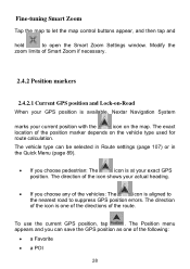
...the position marker depends on the map. The exact location of the following: • a Favorite • a POI 28 To use the current GPS position, tap . The Position menu appears and you can be selected in Route settings (page 107) or in the Quick Menu (page 89).... zoom limits of the route. The vehicle type can save the GPS position as one of the directions of Smart Zoom if necessary. 2.4.2 Position markers 2.4.2.1 Current GPS position and Lock-on-Road When your GPS position is available, Nextar Navigation System marks your actual heading. • If you choose pedestrian...
...the position marker depends on the map. The exact location of the following: • a Favorite • a POI 28 To use the current GPS position, tap . The Position menu appears and you can be selected in Route settings (page 107) or in the Quick Menu (page 89).... zoom limits of the route. The vehicle type can save the GPS position as one of the directions of Smart Zoom if necessary. 2.4.2 Position markers 2.4.2.1 Current GPS position and Lock-on-Road When your GPS position is available, Nextar Navigation System marks your actual heading. • If you choose pedestrian...
ME Software Manual
Page 30
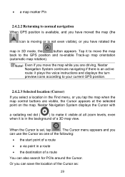
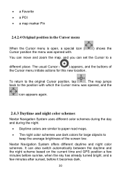
...; the start point of a route • a via point in a route • the destination of the Cursor as: 29 Note! Nextar Navigation System displays the Cursor with a radiating red dot ( ) to your current GPS position. 2.4.2.3 Selected location (Cursor) If you select a location in the Find menu, or you have moved the map (the icon...
...; the start point of a route • a via point in a route • the destination of the Cursor as: 29 Note! Nextar Navigation System displays the Cursor with a radiating red dot ( ) to your current GPS position. 2.4.2.3 Selected location (Cursor) If you select a location in the Find menu, or you have moved the map (the icon...
ME Software Manual
Page 31
...place. The map jumps back to the position with which the Cursor menu was opened , and the icon appears again. 2.4.3 Daytime and night color schemes Nextar Navigation System uses different color schemes during the day and during the night. • Daytime colors are similar to paper road maps. • The night ... move and zoom the map, and you can also switch automatically between the daytime and the night scheme based on the current time and GPS position a few minutes before sunrise, when the sky has already turned bright, and a few minutes after sunset, before it becomes dark. 30...
...place. The map jumps back to the position with which the Cursor menu was opened , and the icon appears again. 2.4.3 Daytime and night color schemes Nextar Navigation System uses different color schemes during the day and during the night. • Daytime colors are similar to paper road maps. • The night ... move and zoom the map, and you can also switch automatically between the daytime and the night scheme based on the current time and GPS position a few minutes before sunrise, when the sky has already turned bright, and a few minutes after sunset, before it becomes dark. 30...
ME Software Manual
Page 35
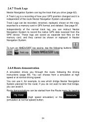
... calculated. You can instruct Nextar Navigation System to a memory card in Nextar Navigation System. See page 97. You can log the track that bridge, you drive (page 62). These logs are saved as separate text files on the map, exported to record the native GPS data received from the Route menu by tapping the (high speed...
... calculated. You can instruct Nextar Navigation System to a memory card in Nextar Navigation System. See page 97. You can log the track that bridge, you drive (page 62). These logs are saved as separate text files on the map, exported to record the native GPS data received from the Route menu by tapping the (high speed...

ME Software Manual
Page 38
...8226; Enter a full address or a part of an address, for example a street name without a house number or the names of a route Nextar Navigation System offers you several ways: • if you need a simple route (a route with only one destination, without any intermediate via points), you...page 51) • a POI (page 51) • the History of previously set up your route in Nextar Navigation System in several ways of choosing your current GPS position or even without GPS reception (available in Advanced mode only) 3.1 Selecting the destination of two intersecting streets (page 39). •...
...8226; Enter a full address or a part of an address, for example a street name without a house number or the names of a route Nextar Navigation System offers you several ways: • if you need a simple route (a route with only one destination, without any intermediate via points), you...page 51) • a POI (page 51) • the History of previously set up your route in Nextar Navigation System in several ways of choosing your current GPS position or even without GPS reception (available in Advanced mode only) 3.1 Selecting the destination of two intersecting streets (page 39). •...

ME Software Manual
Page 63
Tap it to cancel the 3.11 Using Track Logs Nextar Navigation System can record the track (how your driving path while cruising. Recording the travelled path (creating a Track Log) 1. Tap the following buttons: , , . 3. button appears. you ... the Route Information screen. If via points disappear and the whole route. The procedure is available in the active route, you can also record your GPS position changed) that you can continue driving. 62 Tip! Start the recording: tap the button. Note! This feature is explained starting from the Map screen...
Tap it to cancel the 3.11 Using Track Logs Nextar Navigation System can record the track (how your driving path while cruising. Recording the travelled path (creating a Track Log) 1. Tap the following buttons: , , . 3. button appears. you ... the Route Information screen. If via points disappear and the whole route. The procedure is available in the active route, you can also record your GPS position changed) that you can continue driving. 62 Tip! Start the recording: tap the button. Note! This feature is explained starting from the Map screen...
ME Software Manual
Page 65
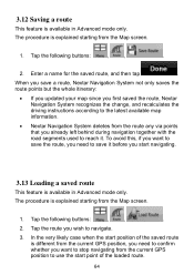
... the road segments used to reach it before you want to stop navigating from the current GPS position to use the start position of the loaded route. 64 When you save a route, Nextar Navigation System not only saves the route points but the whole itinerary: •... If you updated your map since you first saved the route, Nextar Navigation System recognizes the change, and recalculates the driving instructions according to the latest available map information. • Nextar Navigation System deletes from the current GPS position, you need to confirm whether you want to save it ...
... the road segments used to reach it before you want to stop navigating from the current GPS position to use the start position of the loaded route. 64 When you save a route, Nextar Navigation System not only saves the route points but the whole itinerary: •... If you updated your map since you first saved the route, Nextar Navigation System recognizes the change, and recalculates the driving instructions according to the latest available map information. • Nextar Navigation System deletes from the current GPS position, you need to confirm whether you want to save it ...
ME Software Manual
Page 73
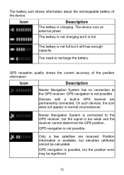
You need to the GPS receiver: GPS navigation is possible, but elevation (altitude) cannot be significant. 72 Only a few satellites are permanently connected. GPS navigation is not possible. GPS reception quality shows the current accuracy of the device. Icon Description Nextar Navigation System has no connection to recharge the battery. Devices with a built-in normal circumstances. GPS navigation is charging. Position information...
You need to the GPS receiver: GPS navigation is possible, but elevation (altitude) cannot be significant. 72 Only a few satellites are permanently connected. GPS navigation is not possible. GPS reception quality shows the current accuracy of the device. Icon Description Nextar Navigation System has no connection to recharge the battery. Devices with a built-in normal circumstances. GPS navigation is charging. Position information...
ME Software Manual
Page 74
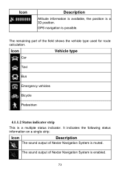
GPS navigation is enabled. 73 The sound output of Nextar Navigation System is possible. Icon Description Altitude information is available, the position is muted. The remaining part of Nextar Navigation System is a 3D position. It indicates the following status information on a single strip: Icon Description The sound output of the field shows the vehicle type used for route calculation. Icon Vehicle type Car Taxi Bus Emergency vehicles Bicycle Pedestrian 4.1.1.2 Status indicator strip This is a multiple status indicator.
GPS navigation is enabled. 73 The sound output of Nextar Navigation System is possible. Icon Description Altitude information is available, the position is muted. The remaining part of Nextar Navigation System is a 3D position. It indicates the following status information on a single strip: Icon Description The sound output of the field shows the vehicle type used for route calculation. Icon Vehicle type Car Taxi Bus Emergency vehicles Bicycle Pedestrian 4.1.1.2 Status indicator strip This is a multiple status indicator.


