User Manual
Page 4
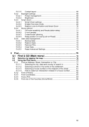
Table of contents 1 Warnings and safety information 8 2 General information 10 3 Operating The NVX200 Navigator (Controls 12 3.1 Hardware buttons 12 3.2 Screen buttons and controls 15 3.2.1 Direct selectors 15 3.2.2 List selectors 16 3.2.3 Sliders 16 ...program through the screens 20 4.1 Main menu 20 4.2 About screen 21 4.3 GPS Data screen 21 4.3.1 GPS data displayed 21 4.3.2 GPS connection indicator 22 4.3.3 GPS data quality indicator 22 4.3.4 Time synchronization 23 4.4 The map ...23 4.4.1 2D and 3D map views 24 4.4.2 Zoom levels 24 4.4.3 Daylight and night color schemes 25 ...
Table of contents 1 Warnings and safety information 8 2 General information 10 3 Operating The NVX200 Navigator (Controls 12 3.1 Hardware buttons 12 3.2 Screen buttons and controls 15 3.2.1 Direct selectors 15 3.2.2 List selectors 16 3.2.3 Sliders 16 ...program through the screens 20 4.1 Main menu 20 4.2 About screen 21 4.3 GPS Data screen 21 4.3.1 GPS data displayed 21 4.3.2 GPS connection indicator 22 4.3.3 GPS data quality indicator 22 4.3.4 Time synchronization 23 4.4 The map ...23 4.4.1 2D and 3D map views 24 4.4.2 Zoom levels 24 4.4.3 Daylight and night color schemes 25 ...
User Manual
Page 5
... 3 31 4.5.3 Tilt up and down (No. 4 & 5 32 4.5.4 Lock to GPS position and heading (No. 6 32 4.5.5 Cursor (No. 7 33 4.5.6 Map scale (No. 8 33 4.5.7 Menu (No. 9 34 4.5.8 Map orientation and Overview (No. 10 34 4.5.9 GPS position quality (No. 11 35 4.5.10 Battery status (No. 12 35 4.5.11 Sound... point 41 4.6.2 Warning icons 41 4.6.3 Fit to screen 42 4.6.4 Parameters 43 4.7 Menu...43 4.7.1 Find tab 43 4.7.2 Quick tab 43 4.7.2.1 3D Map 43 4.7.2.2 Zoom & Tilt 44 4.7.2.3 Night Mode 44 4.7.2.4 Manage POI (Points of Interest 44 4.7.2.5 Popup Info 47 4.7.2.6 Manage Track Logs 47 4.7.3...
... 3 31 4.5.3 Tilt up and down (No. 4 & 5 32 4.5.4 Lock to GPS position and heading (No. 6 32 4.5.5 Cursor (No. 7 33 4.5.6 Map scale (No. 8 33 4.5.7 Menu (No. 9 34 4.5.8 Map orientation and Overview (No. 10 34 4.5.9 GPS position quality (No. 11 35 4.5.10 Battery status (No. 12 35 4.5.11 Sound... point 41 4.6.2 Warning icons 41 4.6.3 Fit to screen 42 4.6.4 Parameters 43 4.7 Menu...43 4.7.1 Find tab 43 4.7.2 Quick tab 43 4.7.2.1 3D Map 43 4.7.2.2 Zoom & Tilt 44 4.7.2.3 Night Mode 44 4.7.2.4 Manage POI (Points of Interest 44 4.7.2.5 Popup Info 47 4.7.2.6 Manage Track Logs 47 4.7.3...
User Manual
Page 6
...speeding tolerance 58 5.1.5 Off-route Recalculation 59 5.1.5.1 Automatic 59 5.1.5.2 Ask First 59 5.1.5.3 Disabled 59 5.2 Map settings 60 5.2.1 Daylight / Night color profile 60 5.2.2 Cockpit / Map mode map details 60 5.2.3 Alternative Road Names 60 5.2.4 Show Street Labels 60 5.2.5 Textured Polygons 61 5.3 Sound ... Voice language 66 5.5.3 Units...66 5.5.4 Set Date & Time Format 66 5.6 Advanced settings 66 5.6.1 Display options 67 5.6.1.1 2D in Map mode (and north-up orientation 67 5.6.1.2 3D in Cockpit mode (and track-up orientation 67 5.6.1.3 Zoom in after find 68 5.6.1.4 ...
...speeding tolerance 58 5.1.5 Off-route Recalculation 59 5.1.5.1 Automatic 59 5.1.5.2 Ask First 59 5.1.5.3 Disabled 59 5.2 Map settings 60 5.2.1 Daylight / Night color profile 60 5.2.2 Cockpit / Map mode map details 60 5.2.3 Alternative Road Names 60 5.2.4 Show Street Labels 60 5.2.5 Textured Polygons 61 5.3 Sound ... Voice language 66 5.5.3 Units...66 5.5.4 Set Date & Time Format 66 5.6 Advanced settings 66 5.6.1 Display options 67 5.6.1.1 2D in Map mode (and north-up orientation 67 5.6.1.2 3D in Cockpit mode (and track-up orientation 67 5.6.1.3 Zoom in after find 68 5.6.1.4 ...
User Manual
Page 7
... management 73 5.6.5.1 Backup Data 73 5.6.5.2 Restore Data 73 5.6.5.3 Remove Pins 73 5.6.5.4 Clear Data 74 5.6.5.5 Reset Advanced Settings 74 6 Find 76 6.1 Find & GO (Main menu 76 6.2 Selection by tapping the map 76 6.3 Using the Find menu 77 6.3.1 Find an Address, Street, Intersection or City 77 6.3.1.1 Selecting the city, state and country to search...
... management 73 5.6.5.1 Backup Data 73 5.6.5.2 Restore Data 73 5.6.5.3 Remove Pins 73 5.6.5.4 Clear Data 74 5.6.5.5 Reset Advanced Settings 74 6 Find 76 6.1 Find & GO (Main menu 76 6.2 Selection by tapping the map 76 6.3 Using the Find menu 77 6.3.1 Find an Address, Street, Intersection or City 77 6.3.1.1 Selecting the city, state and country to search...
User Manual
Page 10
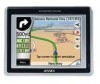
...to Page 76 of this Owners manual for detailed instruction The NVX200 Navigator is located on the memory card. This will show a detailed description of the unit. Just insert the memory card and go wherever you do not need to go . The only exceptions are designed so that you can ... have complete freedom to 'double tap' or 'tap & hold' the touch screen as these functions cannot be used reliably in a moving the map, or scaling it in the top right corner. It provides door-to use The NVX200 Navigator is a navigation system optimized for both single and multi-point routes ...
...to Page 76 of this Owners manual for detailed instruction The NVX200 Navigator is located on the memory card. This will show a detailed description of the unit. Just insert the memory card and go wherever you do not need to go . The only exceptions are designed so that you can ... have complete freedom to 'double tap' or 'tap & hold' the touch screen as these functions cannot be used reliably in a moving the map, or scaling it in the top right corner. It provides door-to use The NVX200 Navigator is a navigation system optimized for both single and multi-point routes ...
User Manual
Page 12
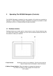
... buttons Hardware buttons are operable by fingertips, or Stylus. Wherever possible, pushbuttons and lists are provided to make your selection. 1 2 1.Touch Screen Display the output of your appliance. All controls are mostly used on list screens to select menu commands or enter information. 2. In... addition you can use the direction buttons and Enter on map screens to zoom, tilt and rotate the map, or to open other screens. 3 Operating The NVX200 Navigator (Controls) The NVX200 Navigator is fully charged, the Indicator will turn to green. 12 Battery Charge...
... buttons Hardware buttons are operable by fingertips, or Stylus. Wherever possible, pushbuttons and lists are provided to make your selection. 1 2 1.Touch Screen Display the output of your appliance. All controls are mostly used on list screens to select menu commands or enter information. 2. In... addition you can use the direction buttons and Enter on map screens to zoom, tilt and rotate the map, or to open other screens. 3 Operating The NVX200 Navigator (Controls) The NVX200 Navigator is fully charged, the Indicator will turn to green. 12 Battery Charge...
User Manual
Page 20
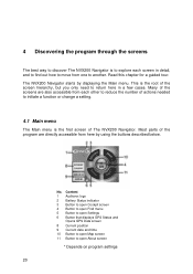
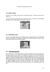
... open Cockpit screen 4 Button to open Find menu 5 Button to open Settings 6 Button that displays GPS Status and Opens GPS Data screen 8 Current position 9 Current date and time 10 Button to open Map screen 11 Button to open About screen * Depends on program settings 20 This is the first screen ...of The NVX200 Navigator. The NVX200 Navigator starts by using the buttons described below. Most parts of ...
... open Cockpit screen 4 Button to open Find menu 5 Button to open Settings 6 Button that displays GPS Status and Opens GPS Data screen 8 Current position 9 Current date and time 10 Button to open Map screen 11 Button to open About screen * Depends on program settings 20 This is the first screen ...of The NVX200 Navigator. The NVX200 Navigator starts by using the buttons described below. Most parts of ...
User Manual
Page 21
...inform you about the map licenses you can see the satellite signal strength bars. The more satellites your GPS tracks (the green ones), the better your current location. On the right you have, the creators of The NVX200 Navigator and the legal aspects of information received from the red ones.... To identify satellites use their current positions. The GPS Data screen is here to open this screen. Grey bars are for the ...
...inform you about the map licenses you can see the satellite signal strength bars. The more satellites your GPS tracks (the green ones), the better your current location. On the right you have, the creators of The NVX200 Navigator and the legal aspects of information received from the red ones.... To identify satellites use their current positions. The GPS Data screen is here to open this screen. Grey bars are for the ...
User Manual
Page 23
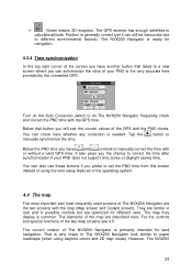
...to a new screen where you prefer to manually correct the time with the GPS time. They are similar in possible controls but are described here. The map they display is why maps in The NVX200 Navigator look and in look similar to calculate altitude. That is common. Green...have another button that button you will see 4.5. You can synchronize the clock of the two map screens see the current values of the map are optimized for different uses. The GPS receiver has enough satellites to paper roadmaps (when using the time setup features of the operating system....
...to a new screen where you prefer to manually correct the time with the GPS time. They are similar in possible controls but are described here. The map they display is why maps in The NVX200 Navigator look and in look similar to calculate altitude. That is common. Green...have another button that button you will see 4.5. You can synchronize the clock of the two map screens see the current values of the map are optimized for different uses. The GPS receiver has enough satellites to paper roadmaps (when using the time setup features of the operating system....
User Manual
Page 24
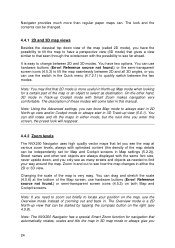
... in either mode, but the next time you see the map at various zoom levels, always with Smart Zoom makes navigation very comfortable. The Overview mode is very easy. Note: The NVX200 Navigator has a special Smart Zoom function for navigation that let you enter this manual. Note: If...font size, never upside down view of the map (called 2D mode), you 24 The description of these modes will reappear. 4.4.2 Zoom levels The NVX200 Navigator uses high quality vector maps that automatically rotates, scales and tilts the map in 3D map mode to always give you have the possibility to...
... in either mode, but the next time you see the map at various zoom levels, always with Smart Zoom makes navigation very comfortable. The Overview mode is very easy. Note: The NVX200 Navigator has a special Smart Zoom function for navigation that let you enter this manual. Note: If...font size, never upside down view of the map (called 2D mode), you 24 The description of these modes will reappear. 4.4.2 Zoom levels The NVX200 Navigator uses high quality vector maps that automatically rotates, scales and tilts the map in 3D map mode to always give you have the possibility to...
User Manual
Page 25
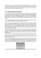
.... You can automatically switch between day and night views manually in the Quick Menu (4.7.2.3) or let The NVX200 Navigator do it automatically (5.1.3) for the sun in the sky in the map background using a flat 3D view. Note: The colors mentioned and screenshots included in this manual refer to let you...and night color schemes accordingly. Using that suits your needs the best, make your current situation. It is based upon the current date and GPS position by which The NVX200 Navigator calculates the exact sunrise and sunset times on the screen. If the next turn , it gets dark.
.... You can automatically switch between day and night views manually in the Quick Menu (4.7.2.3) or let The NVX200 Navigator do it automatically (5.1.3) for the sun in the sky in the map background using a flat 3D view. Note: The colors mentioned and screenshots included in this manual refer to let you...and night color schemes accordingly. Using that suits your needs the best, make your current situation. It is based upon the current date and GPS position by which The NVX200 Navigator calculates the exact sunrise and sunset times on the screen. If the next turn , it gets dark.
User Manual
Page 26
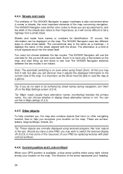
...colored surfaces. 4.4.6 Current position and Lock-on-Road When your GPS position is available, a blue arrow (yellow when using night colors) shows your location on the map. it displays the name of the map concerning navigation. At first you , the map also contains objects that look natural to , and the width ... your PND by street names during navigation, turn them off (5.2.5) to tell a highway from a small street. The conventional way is on the map. The NVX200 Navigator will not be able to have a slow PND, you may find it odd, but later you recognize your location on the...
...colored surfaces. 4.4.6 Current position and Lock-on-Road When your GPS position is available, a blue arrow (yellow when using night colors) shows your location on the map. it displays the name of the map concerning navigation. At first you , the map also contains objects that look natural to , and the width ... your PND by street names during navigation, turn them off (5.2.5) to tell a highway from a small street. The conventional way is on the map. The NVX200 Navigator will not be able to have a slow PND, you may find it odd, but later you recognize your location on the...
User Manual
Page 27
... or select a specific item in Find, it will become the selected point on the map, marked with a small red dot and permanently radiating red circles to make it is in advanced settings (5.6.5.3). 27 The location received from the GPS receiver is shown as being stuck in case of one-way streets, or on the... puts the position arrow on the road, on the axis of your position if the GPS accuracy is poor, and the Lock-on-Road system puts you tap the Lock button, or after the given timeout The NVX200 Navigator restores Lock-to-Position (5.6.3.3), and the Cursor jumps back to -Position is active...
... or select a specific item in Find, it will become the selected point on the map, marked with a small red dot and permanently radiating red circles to make it is in advanced settings (5.6.5.3). 27 The location received from the GPS receiver is shown as being stuck in case of one-way streets, or on the... puts the position arrow on the road, on the axis of your position if the GPS accuracy is poor, and the Lock-on-Road system puts you tap the Lock button, or after the given timeout The NVX200 Navigator restores Lock-to-Position (5.6.3.3), and the Cursor jumps back to -Position is active...

User Manual
Page 28
...the point and start Find Coordinates (6.3.3). 4.4.9 Visible POIs (Points of Interest) The NVX200 Navigator comes with street names (5.2.4). This will be changed later). Tip: Tap the map on the map represent pOIs. This way you also save the coordinates with the pin for the ...small dots appear at the locations of the pin. The NVX200 Navigator automatically selects the color of visible POIs. In the Cursor menu (4.5.13) there is enabled (4.7.2.5). Tip: A quick way to see their address and GPS coordinates. Zooming in the History list (6.3.2) later. Different colors...
...the point and start Find Coordinates (6.3.3). 4.4.9 Visible POIs (Points of Interest) The NVX200 Navigator comes with street names (5.2.4). This will be changed later). Tip: Tap the map on the map represent pOIs. This way you also save the coordinates with the pin for the ...small dots appear at the locations of the pin. The NVX200 Navigator automatically selects the color of visible POIs. In the Cursor menu (4.5.13) there is enabled (4.7.2.5). Tip: A quick way to see their address and GPS coordinates. Zooming in the History list (6.3.2) later. Different colors...
User Manual
Page 29
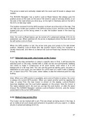
.... The line of the route is displayed on the driving side of the road for two-way and on the map. 4.4.10.1 The start point (your current location if GPS position is available), a destination, the line of the active leg of the route, and optionally via points and inactive legs. They...colors, and yellow with the night color scheme, both cases it is the most conspicuous part of the map even when in the background of the route. 4.4.10 Elements of the Active Route The NVX200 Navigator uses a multi-destination routing system in which you need to continue your journey. 4.4.10.3 The active...
.... The line of the route is displayed on the driving side of the road for two-way and on the map. 4.4.10.1 The start point (your current location if GPS position is available), a destination, the line of the active leg of the route, and optionally via points and inactive legs. They...colors, and yellow with the night color scheme, both cases it is the most conspicuous part of the map even when in the background of the route. 4.4.10 Elements of the Active Route The NVX200 Navigator uses a multi-destination routing system in which you need to continue your journey. 4.4.10.3 The active...

User Manual
Page 30
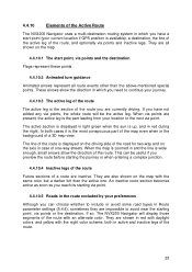
...the current street), and some more route data if you can set The NVX200 Navigator so it contains some additional travel , type of the map screens follows. This screen is to be used mainly without a GPS, to browse the map, create user POI items, or to travel information if you are just ... your are described on the two screens. This screen is designed to give you can make The NVX200 Navigator always open the Cockpit screen like that - Display 30 Control 4.5 Screens with map Having explained the contents of the map, the description of the other parts of the next route event). The...
...the current street), and some more route data if you can set The NVX200 Navigator so it contains some additional travel , type of the map screens follows. This screen is to be used mainly without a GPS, to browse the map, create user POI items, or to travel information if you are just ... your are described on the two screens. This screen is designed to give you can make The NVX200 Navigator always open the Cockpit screen like that - Display 30 Control 4.5 Screens with map Having explained the contents of the map, the description of the other parts of the next route event). The...
User Manual
Page 31
... graphic illustration of the exit is also given in /out by dragging 9 N/a Menu (Find, Quick, Route, Main) 10 Map orientation and Overview Switches North-up, Track-up (optional) 6 Indicates that Lock to GPS position and Re-enables Lock-to-Position / Smart Zoom heading is inactive 7 Selected... map point (Cursor) Opens Popup Info and Cursor menu 8 (Map only) Map scale Zooms in the picture. The Map screen will show a button called Route here if ...
... graphic illustration of the exit is also given in /out by dragging 9 N/a Menu (Find, Quick, Route, Main) 10 Map orientation and Overview Switches North-up, Track-up (optional) 6 Indicates that Lock to GPS position and Re-enables Lock-to-Position / Smart Zoom heading is inactive 7 Selected... map point (Cursor) Opens Popup Info and Cursor menu 8 (Map only) Map scale Zooms in the picture. The Map screen will show a button called Route here if ...
User Manual
Page 32
...No. 6) This semi-transparent icon is displayed if GPS position is enabled in 3D mode. Zoom out shows a larger part of the map, while Zoom in shows a smaller part of the map in the Quick menu (4.7.2.2). You can also set The NVX200 Navigator to do this function modifies the vertical viewing... angle of the map in Error! You need to press Enter (3.1), or ...
...No. 6) This semi-transparent icon is displayed if GPS position is enabled in 3D mode. Zoom out shows a larger part of the map, while Zoom in shows a smaller part of the map in the Quick menu (4.7.2.2). You can also set The NVX200 Navigator to do this function modifies the vertical viewing... angle of the map in Error! You need to press Enter (3.1), or ...
User Manual
Page 33
...). This can be turned on for re-enabling both 2D and 3D modes to scale the map. In 2D map view it right to zoom in, or left to zoom out. 33 To return to the GPS position, use it in both Lock-to-Position and Smart Zoom. 4.5.5 Cursor (No. 7) As described in... scale of the nearest part of the map (when Track-up orientation (the one specific item in 3.1. In 3D view it is enabled, scaling or tilting the map also stops the automatic zooming or automatic tilting respectively. Normally The NVX200 Navigator positions the map to keep the GPS position visible. If you manually move the...
...). This can be turned on for re-enabling both 2D and 3D modes to scale the map. In 2D map view it right to zoom in, or left to zoom out. 33 To return to the GPS position, use it in both Lock-to-Position and Smart Zoom. 4.5.5 Cursor (No. 7) As described in... scale of the nearest part of the map (when Track-up orientation (the one specific item in 3.1. In 3D view it is enabled, scaling or tilting the map also stops the automatic zooming or automatic tilting respectively. Normally The NVX200 Navigator positions the map to keep the GPS position visible. If you manually move the...

User Manual
Page 34
.... This mode is Track-up (automatic rotation) mode. 34 It means The NVX200 Navigator rotates the map during navigation when the next turn is fixed to North-up The NVX200 Navigator so that takes you are on the map. The arrow representing your position will be described in detail later in... 4.7. 4.5.8 Map orientation and Overview (No. 10) You can change the zoom level at any time, this ...
.... This mode is Track-up (automatic rotation) mode. 34 It means The NVX200 Navigator rotates the map during navigation when the next turn is fixed to North-up The NVX200 Navigator so that takes you are on the map. The arrow representing your position will be described in detail later in... 4.7. 4.5.8 Map orientation and Overview (No. 10) You can change the zoom level at any time, this ...


