User Manual
Page 1
User Manual GPS navigation software for Audiovox NVX200 English R : 00 Owners manual :128-8219 VE
User Manual GPS navigation software for Audiovox NVX200 English R : 00 Owners manual :128-8219 VE
User Manual
Page 4
Table of contents 1 Warnings and safety information 8 2 General information 10 3 Operating The NVX200 Navigator (Controls 12 3.1 Hardware buttons 12 3.2 Screen buttons and controls 15 3.2.1 Direct selectors 15 3.2.2 List selectors 16 3.2.3 Sliders 16 ...3.2.7.3 The numeric keyboard 19 4 Discovering the program through the screens 20 4.1 Main menu 20 4.2 About screen 21 4.3 GPS Data screen 21 4.3.1 GPS data displayed 21 4.3.2 GPS connection indicator 22 4.3.3 GPS data quality indicator 22 4.3.4 Time synchronization 23 4.4 The map ...23 4.4.1 2D and 3D map views 24 4.4.2 Zoom ...
Table of contents 1 Warnings and safety information 8 2 General information 10 3 Operating The NVX200 Navigator (Controls 12 3.1 Hardware buttons 12 3.2 Screen buttons and controls 15 3.2.1 Direct selectors 15 3.2.2 List selectors 16 3.2.3 Sliders 16 ...3.2.7.3 The numeric keyboard 19 4 Discovering the program through the screens 20 4.1 Main menu 20 4.2 About screen 21 4.3 GPS Data screen 21 4.3.1 GPS data displayed 21 4.3.2 GPS connection indicator 22 4.3.3 GPS data quality indicator 22 4.3.4 Time synchronization 23 4.4 The map ...23 4.4.1 2D and 3D map views 24 4.4.2 Zoom ...
User Manual
Page 5
... 29 4.5 Screens with map 30 4.5.1 Turn preview (No. 1 31 4.5.2 Zoom in and out (No. 2 & 3 31 4.5.3 Tilt up and down (No. 4 & 5 32 4.5.4 Lock to GPS position and heading (No. 6 32 4.5.5 Cursor (No. 7 33 4.5.6 Map scale (No. 8 33 4.5.7 Menu (No. 9 34 4.5.8 Map orientation and Overview (No. 10 34... 4.5.9 GPS position quality (No. 11 35 4.5.10 Battery status (No. 12 35 4.5.11 Sound muting (No. 13 35 4.5.12 Track Log recording/playback indicator (No. 14 ...
... 29 4.5 Screens with map 30 4.5.1 Turn preview (No. 1 31 4.5.2 Zoom in and out (No. 2 & 3 31 4.5.3 Tilt up and down (No. 4 & 5 32 4.5.4 Lock to GPS position and heading (No. 6 32 4.5.5 Cursor (No. 7 33 4.5.6 Map scale (No. 8 33 4.5.7 Menu (No. 9 34 4.5.8 Map orientation and Overview (No. 10 34... 4.5.9 GPS position quality (No. 11 35 4.5.10 Battery status (No. 12 35 4.5.11 Sound muting (No. 13 35 4.5.12 Track Log recording/playback indicator (No. 14 ...
User Manual
Page 8
... cause injuries in (optional) Safety Mode that will be the only one to operate The NVX200 Navigator, we recommend that you operate The NVX200 Navigator before departure and pull over if you need to deviate from the GPS receiver will not be transmitted anywhere, so others will not be on the Safety Mode. You...
... cause injuries in (optional) Safety Mode that will be the only one to operate The NVX200 Navigator, we recommend that you operate The NVX200 Navigator before departure and pull over if you need to deviate from the GPS receiver will not be transmitted anywhere, so others will not be on the Safety Mode. You...
User Manual
Page 15
...carrying out the pre-installation on the screen, with metal-coated windows) it must be able to at least 4 of The NVX200 Navigator is the touch screen. With the help of the icons to a PC by tapping. Interface for some hours, it is possible to determine ...Note: z By limited line of possible values. This process may take a while. z If the GPS receiver has not been active for connecting to change the value. 15 GPS(Global Positioning System) GPS is reestablished again. The satellite reception however automatically picks up must orientate itself again. If the values ...
...carrying out the pre-installation on the screen, with metal-coated windows) it must be able to at least 4 of The NVX200 Navigator is the touch screen. With the help of the icons to a PC by tapping. Interface for some hours, it is possible to determine ...Note: z By limited line of possible values. This process may take a while. z If the GPS receiver has not been active for connecting to change the value. 15 GPS(Global Positioning System) GPS is reestablished again. The satellite reception however automatically picks up must orientate itself again. If the values ...
User Manual
Page 20
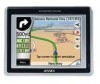
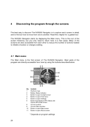
...logo 2 Battery Status indicator 3 Button to open Cockpit screen 4 Button to open Find menu 5 Button to open Settings 6 Button that displays GPS Status and Opens GPS Data screen 8 Current position 9 Current date and time 10 Button to open About screen * Depends on program settings 20 4 Discovering the program ...through the screens The best way to discover The NVX200 Navigator is the first screen of The NVX200 Navigator. This is the root...
...logo 2 Battery Status indicator 3 Button to open Cockpit screen 4 Button to open Find menu 5 Button to open Settings 6 Button that displays GPS Status and Opens GPS Data screen 8 Current position 9 Current date and time 10 Button to open About screen * Depends on program settings 20 4 Discovering the program ...through the screens The best way to discover The NVX200 Navigator is the first screen of The NVX200 Navigator. This is the root...
User Manual
Page 21
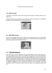
... ones are for the green satellites. Grey bars are for the grey and black bars are used in no It is a collection of information received from the GPS device and it also serves as the centre. On the right you can see the satellite signal strength bars. Signals from the red ones... (the green ones), the better your calculated position will be. 21 The GPS Data screen is here to inform you about the map licenses you have, the creators of The NVX200 Navigator and the legal aspects of using the program. 4.3 GPS Data screen Tap the small satellite dish icon in the virtual sky.
... ones are for the green satellites. Grey bars are for the grey and black bars are used in no It is a collection of information received from the GPS device and it also serves as the centre. On the right you can see the satellite signal strength bars. Signals from the red ones... (the green ones), the better your calculated position will be. 21 The GPS Data screen is here to inform you about the map licenses you have, the creators of The NVX200 Navigator and the legal aspects of using the program. 4.3 GPS Data screen Tap the small satellite dish icon in the virtual sky.

User Manual
Page 22
... no connection with a red cross means there is no connection to the GPS receiver, but the GPS is not provided, and the position error may be affected by using enough satellites for calculating the horizontal position only. A GPS position has been acquired, The NVX200 Navigator is ready for switches. Red lamp means connection to any...
... no connection with a red cross means there is no connection to the GPS receiver, but the GPS is not provided, and the position error may be affected by using enough satellites for calculating the horizontal position only. A GPS position has been acquired, The NVX200 Navigator is ready for switches. Red lamp means connection to any...
User Manual
Page 23
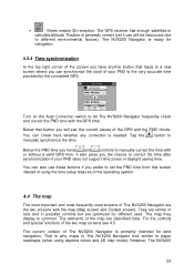
... instead of using daytime colors and 2D map mode). You can synchronize the clock of the GPS and the PND clocks. For the controls and special functions of The NVX200 Navigator are described here. Tap the manually synchronize the time. Green means 3D reception. The ...switch to calculate altitude. They are optimized for land navigation. However, The NVX200 23 The GPS receiver has enough satellites to let The NVX200 Navigator frequently check and correct the PND time with or without a valid GPS time. Below that leads to paper roadmaps (when using the time setup ...
... instead of using daytime colors and 2D map mode). You can synchronize the clock of the GPS and the PND clocks. For the controls and special functions of The NVX200 Navigator are described here. Tap the manually synchronize the time. Green means 3D reception. The ...switch to calculate altitude. They are optimized for land navigation. However, The NVX200 23 The GPS receiver has enough satellites to let The NVX200 Navigator frequently check and correct the PND time with or without a valid GPS time. Below that leads to paper roadmaps (when using the time setup ...
User Manual
Page 25
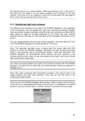
...carefully selected colors to still keep the average brightness of the screen low, with The NVX200 Navigator. Note: The automatic day/night mode is based upon the current date and GPS position by which The NVX200 Navigator calculates the exact sunrise and sunset times on the screen. Using that suits ...your needs the best, make your selection in Settings (5.2.1). They may not look for the sun in the sky in the Quick Menu (4.7.2.3) or let The NVX200 Navigator ...
...carefully selected colors to still keep the average brightness of the screen low, with The NVX200 Navigator. Note: The automatic day/night mode is based upon the current date and GPS position by which The NVX200 Navigator calculates the exact sunrise and sunset times on the screen. Using that suits ...your needs the best, make your selection in Settings (5.2.1). They may not look for the sun in the sky in the Quick Menu (4.7.2.3) or let The NVX200 Navigator ...
User Manual
Page 26
...the map concerning navigation. Streets and roads have alternative names (numbering) besides the primary name. The NVX200 Navigator will discover how it displays the name of the map. You can set this information can...you have no other navigating function than to help orientate you are accustomed to the eye. The NVX200 Navigator uses two different ways to display these alternative names or not. Note: The automatic switching ... identification. The direction of the arrow represents your GPS position is on the Map Settings screen (5.2.4). Of course, this in an instant.
...the map concerning navigation. Streets and roads have alternative names (numbering) besides the primary name. The NVX200 Navigator will discover how it displays the name of the map. You can set this information can...you have no other navigating function than to help orientate you are accustomed to the eye. The NVX200 Navigator uses two different ways to display these alternative names or not. Note: The automatic switching ... identification. The direction of the arrow represents your GPS position is on the Map Settings screen (5.2.4). Of course, this in an instant.
User Manual
Page 27
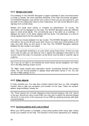
...on the map, marked with a pin. When you tap the Lock button, or after the given timeout The NVX200 Navigator restores Lock-to-Position (5.6.3.3), and the Cursor jumps back to the current GPS position. 4.4.8 Marked map points (Pin) The Cursor can be marked with a small red dot and permanently radiating ... a drawingpin, or save it as a POI. The NVX200 Navigator has a built-in Lock-on-Road feature that Lock-on-Road may choose the wrong street). 4.4.7 Selected map point, also known as a blue dot on the screen. The location received from the GPS receiver is shown as the Cursor If you tap the...
...on the map, marked with a pin. When you tap the Lock button, or after the given timeout The NVX200 Navigator restores Lock-to-Position (5.6.3.3), and the Cursor jumps back to the current GPS position. 4.4.8 Marked map points (Pin) The Cursor can be marked with a small red dot and permanently radiating ... a drawingpin, or save it as a POI. The NVX200 Navigator has a built-in Lock-on-Road feature that Lock-on-Road may choose the wrong street). 4.4.7 Selected map point, also known as a blue dot on the screen. The location received from the GPS receiver is shown as the Cursor If you tap the...

User Manual
Page 28
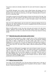
...to show and which ones to -Position (4.5.4). If you do not need this , The NVX200 Navigator lets you can create your journey, just drag the map to disable Lock-to hide (4.7.2.4) using their address and GPS coordinates. To avoid this information during your own POI database as well. For points you...Cursor menu (4.5.13) there is a button called POI that icons overlap, a multi-POI icon is the icon of the subcategory of the pin. The NVX200 Navigator automatically selects the color of the actual POI. Tip: A quick way to see their details, and select any of individual ones. As you ...
...to show and which ones to -Position (4.5.4). If you do not need this , The NVX200 Navigator lets you can create your journey, just drag the map to disable Lock-to hide (4.7.2.4) using their address and GPS coordinates. To avoid this information during your own POI database as well. For points you...Cursor menu (4.5.13) there is a button called POI that icons overlap, a multi-POI icon is the icon of the subcategory of the pin. The NVX200 Navigator automatically selects the color of the actual POI. Tip: A quick way to see their details, and select any of individual ones. As you ...
User Manual
Page 29
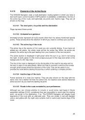
...when entering a complex junction. 4.4.10.4 Inactive legs of the route Future sections of a route are inactive. 4.4.10 Elements of the Active Route The NVX200 Navigator uses a multi-destination routing system in which you need to continue your journey. 4.4.10.3 The active leg of the route The active leg is.... These arrows show the direction of the route, and optionally via point. 4.4.10.5 Roads in the route excluded by your current location if GPS position is displayed on the driving side of the road for two-way and on the map. 4.4.10.1 The start point (your preferences Although...
...when entering a complex junction. 4.4.10.4 Inactive legs of the route Future sections of a route are inactive. 4.4.10 Elements of the Active Route The NVX200 Navigator uses a multi-destination routing system in which you need to continue your journey. 4.4.10.3 The active leg of the route The active leg is.... These arrows show the direction of the route, and optionally via point. 4.4.10.5 Roads in the route excluded by your current location if GPS position is displayed on the driving side of the road for two-way and on the map. 4.4.10.1 The start point (your preferences Although...

User Manual
Page 30
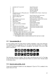
... screens: the Map screen and the Cockpit screen. This screen is designed to give you can set The NVX200 Navigator so it contains some more route data if you can make The NVX200 Navigator always open the Cockpit screen like that function in 3D Track-up mode (you the maximum map area.... They are optimized for driving purposes. The Map screen is typically used mainly without a GPS, to browse the map, create user POI items...
... screens: the Map screen and the Cockpit screen. This screen is designed to give you can set The NVX200 Navigator so it contains some more route data if you can make The NVX200 Navigator always open the Cockpit screen like that function in 3D Track-up mode (you the maximum map area.... They are optimized for driving purposes. The Map screen is typically used mainly without a GPS, to browse the map, create user POI items...
User Manual
Page 31
... menu* 2 N/a Zooms in (optional) 3 N/a Zooms out (optional) 4 N/a Tilts down (optional) 5 N/a Tilts up (optional) 6 Indicates that Lock to GPS position and Re-enables Lock-to-Position / Smart Zoom heading is inactive 7 Selected map point (Cursor) Opens Popup Info and Cursor menu 8 (Map only) Map ... Menu (Find, Quick, Route, Main) 10 Map orientation and Overview Switches North-up, Track-up and Overview 11 GPS position qualité Opens GPS Data screen 12 Battery status Opens settings 13 Sound on or muted Enables/disables muting 14 Track Log recording or playback Opens...
... menu* 2 N/a Zooms in (optional) 3 N/a Zooms out (optional) 4 N/a Tilts down (optional) 5 N/a Tilts up (optional) 6 Indicates that Lock to GPS position and Re-enables Lock-to-Position / Smart Zoom heading is inactive 7 Selected map point (Cursor) Opens Popup Info and Cursor menu 8 (Map only) Map ... Menu (Find, Quick, Route, Main) 10 Map orientation and Overview Switches North-up, Track-up and Overview 11 GPS position qualité Opens GPS Data screen 12 Battery status Opens settings 13 Sound on or muted Enables/disables muting 14 Track Log recording or playback Opens...
User Manual
Page 32
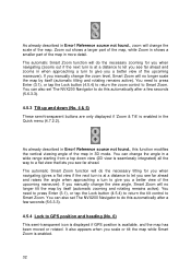
As already described in Error! You can also set The NVX200 Navigator to do this automatically after a few seconds (5.6.3.3). 4.5.4 Lock to GPS position and heading (No. 6) This semi-transparent icon is displayed if GPS position is enabled in the Quick menu (4.7.2.2). Zoom out shows a larger part of the map, while Zoom ... flat view that lets you see far ahead. It also appears when you a better view of the map. You can also set The NVX200 Navigator to Smart Zoom. The automatic Smart Zoom function will do the necessary tilting for you when navigating (zooms out if the next turn...
As already described in Error! You can also set The NVX200 Navigator to do this automatically after a few seconds (5.6.3.3). 4.5.4 Lock to GPS position and heading (No. 6) This semi-transparent icon is displayed if GPS position is enabled in the Quick menu (4.7.2.2). Zoom out shows a larger part of the map, while Zoom ... flat view that lets you see far ahead. It also appears when you a better view of the map. You can also set The NVX200 Navigator to Smart Zoom. The automatic Smart Zoom function will do the necessary tilting for you when navigating (zooms out if the next turn...
User Manual
Page 33
... respectively. In 2D map view it is set a delay time after which The NVX200 Navigator pushes the Lock button for re-enabling both 2D and 3D modes to the current GPS position. To return to the GPS position, use it in any direction will only freeze the orientation of the map ... freeze the map in 3.1. If you can use this button. This button has a hardware button equivalent described in the new position. Normally The NVX200 Navigator positions the map to keep the GPS position visible. Tip: In Advanced settings you manually move the map, it keeps on moving to keep the...
... respectively. In 2D map view it is set a delay time after which The NVX200 Navigator pushes the Lock button for re-enabling both 2D and 3D modes to the current GPS position. To return to the GPS position, use it in any direction will only freeze the orientation of the map ... freeze the map in 3.1. If you can use this button. This button has a hardware button equivalent described in the new position. Normally The NVX200 Navigator positions the map to keep the GPS position visible. Tip: In Advanced settings you manually move the map, it keeps on moving to keep the...

User Manual
Page 35
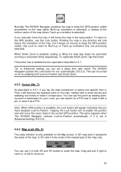
.... • A black dish and two arcs represent a 3D GPS position. You can quickly mute all to be significant, yet The NVX200 Navigator is 2D (no connection with the GPS receiver. The NVX200 Navigator is too weak to give a position. 4.5.9 GPS position quality (No. 11) Similarly to the icon found on... • Battery in not full, but the signal is ready to navigate. 4.5.10 Battery status (No. 12) The NVX200 Navigator also shows the status of the PND. GPS navigation is not possible. • Red shows there is a connection, but there is crossed out. 35 When muting is...
.... • A black dish and two arcs represent a 3D GPS position. You can quickly mute all to be significant, yet The NVX200 Navigator is 2D (no connection with the GPS receiver. The NVX200 Navigator is too weak to give a position. 4.5.9 GPS position quality (No. 11) Similarly to the icon found on... • Battery in not full, but the signal is ready to navigate. 4.5.10 Battery status (No. 12) The NVX200 Navigator also shows the status of the PND. GPS navigation is not possible. • Red shows there is a connection, but there is crossed out. 35 When muting is...
User Manual
Page 36
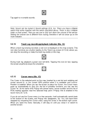
... the Cursor, the Cursor menu pops up on until you have them reappear by a red dot and radiating red circles around it), or the current GPS position when it will stay on the mute indicator. 4.5.12 Track Log recording/playback indicator (No. 14) When a track log is being recorded, a red icon...
... the Cursor, the Cursor menu pops up on until you have them reappear by a red dot and radiating red circles around it), or the current GPS position when it will stay on the mute indicator. 4.5.12 Track Log recording/playback indicator (No. 14) When a track log is being recorded, a red icon...


