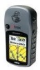
Owner's Manual
Page 10
... Function 2 Battery Installation 3 Backlighting and Contrast 3 The Main Pages Main Page Basics 4 Satellite The Main Page 5 Options 6-7 Navigating Navigating with eTrex Legend 8 Map The Main Page 9-10 Options 11-15 Using the Pan Map Option 12 Stop Navigation 13 Hide/Show Navigation Status 13 Hide/Show Data... 44 Display Page 45 Heading Page 45 Interface Page 46 System Page 47 Accessories 48-51 Sun and Moon 48 Calendar Page 49 Hunt and Fish Page 50 Area Calculator Page 51 Calculator Page 51 Appendices Appendix A: Specifications 52 Appendix B: Accessories 53 Appendix ...
... Function 2 Battery Installation 3 Backlighting and Contrast 3 The Main Pages Main Page Basics 4 Satellite The Main Page 5 Options 6-7 Navigating Navigating with eTrex Legend 8 Map The Main Page 9-10 Options 11-15 Using the Pan Map Option 12 Stop Navigation 13 Hide/Show Navigation Status 13 Hide/Show Data... 44 Display Page 45 Heading Page 45 Interface Page 46 System Page 47 Accessories 48-51 Sun and Moon 48 Calendar Page 49 Hunt and Fish Page 50 Area Calculator Page 51 Calculator Page 51 Appendices Appendix A: Specifications 52 Appendix B: Accessories 53 Appendix ...

Owner's Manual
Page 33
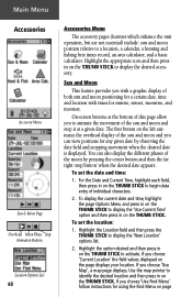
...adjustment, interface setups, heading selection and system software information. Accessories Page - When the unit is active the light bulb to additional eTrex Legend feature pages. Allows tailoring of items such as part of a Route; The battery icon displays the approximate amount of each main...of Interest, Addresses, and Intersections. (Some require MapSource data.) Route Page - Provides access to access Sun and Moon data, a Calendar, Hunting and Fishing data, a Calculator, and an Area Calculator. Allows you to locate, and Goto, or use . Allows you to create and ...
...adjustment, interface setups, heading selection and system software information. Accessories Page - When the unit is active the light bulb to additional eTrex Legend feature pages. Allows tailoring of items such as part of a Route; The battery icon displays the approximate amount of each main...of Interest, Addresses, and Intersections. (Some require MapSource data.) Route Page - Provides access to access Sun and Moon data, a Calendar, Hunting and Fishing data, a Calculator, and an Area Calculator. Allows you to locate, and Goto, or use . Allows you to create and ...

Owner's Manual
Page 38
The Waypoint Information Page displays the waypoint name or number, a map symbol, the location in the eTrex Legend can be found by selecting the "Waypoint' option from this location, view sun and moon, and best fishing and hunting time information for this waypoint. To find a waypoint: 1. With the Information Page displayed, you...
The Waypoint Information Page displays the waypoint name or number, a map symbol, the location in the eTrex Legend can be found by selecting the "Waypoint' option from this location, view sun and moon, and best fishing and hunting time information for this waypoint. To find a waypoint: 1. With the Information Page displayed, you...
Owner's Manual
Page 58
Highlight the Location field and then press the THUMB STICK to a location, a calendar, a hunting and fishing best times record, an area calculator, and a basic calculator. If you choose 'Use Find Menu' follow instructions for using the Find Menu ...
Highlight the Location field and then press the THUMB STICK to a location, a calendar, a hunting and fishing best times record, an area calculator, and a basic calculator. If you choose 'Use Find Menu' follow instructions for using the Find Menu ...
Owner's Manual
Page 59
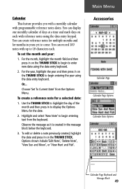
... Use the THUMB STICK to display the Options Menu for the date. 2. Options shown include 'Edit Note', 'Delete Note', 'View Sun and Moon', or 'View Hunt and Fish'. Calendar This feature provides you with a monthly calendar with reference notes using the data entry keypad. To create a reference note for months in...
... Use the THUMB STICK to display the Options Menu for the date. 2. Options shown include 'Edit Note', 'Delete Note', 'View Sun and Moon', or 'View Hunt and Fish'. Calendar This feature provides you with a monthly calendar with reference notes using the data entry keypad. To create a reference note for months in...

Owner's Manual
Page 60
... This feature provides you with state and local game laws which may vary from location to begin data entry of best times for hunting and fishing for hunting and fishing. Highlight the Location field and then press in on the THUMB STICK to activate. Highlight the option desired and...
... This feature provides you with state and local game laws which may vary from location to begin data entry of best times for hunting and fishing for hunting and fishing. Highlight the Location field and then press in on the THUMB STICK to activate. Highlight the option desired and...

Owner's Manual
Page 71
... use Setup Map options 15 use the Measure Distance option 15 use Track Log Setup options 42 view the next waypoint in the route 39 Hunt and Fish 50 I Installing Batteries 3 Lanyard 2 Interface Page 46 Internal Antenna 2 L Land Cover 15 Land or Water 14 Language 47 LCD Display 2 Leg Course 40...
... use Setup Map options 15 use the Measure Distance option 15 use Track Log Setup options 42 view the next waypoint in the route 39 Hunt and Fish 50 I Installing Batteries 3 Lanyard 2 Interface Page 46 Internal Antenna 2 L Land Cover 15 Land or Water 14 Language 47 LCD Display 2 Leg Course 40...
Owner's Manual
Page 74
Index Map 48 Route 35 Track Log 41, 42 V Velocity Made Good 14, 18, 21, 55 Vertical Speed 14, 18, 21, 44, 55 View Hunt and Fish 49 Sun and Moon 49 View Waypoints on Route 35, 37, 39 W WAAS (Wide Area Augmentation System) Warnings iii, iv Warranty vi, vii Water Immersion v Waypoints 24-27 WGS84 (World Geodetic Survey 1984)..... 44 Wide Area Augmentation System (WAAS) ....... 1, 47 Wiring Diagram 58 www.GARMIN.com vii www.nima.mil 44 Z ZOOM IN 9, 10 ZOOM IN button 2 ZOOM OUT 9, 10 ZOOM OUT button 2 64
Index Map 48 Route 35 Track Log 41, 42 V Velocity Made Good 14, 18, 21, 55 Vertical Speed 14, 18, 21, 44, 55 View Hunt and Fish 49 Sun and Moon 49 View Waypoints on Route 35, 37, 39 W WAAS (Wide Area Augmentation System) Warnings iii, iv Warranty vi, vii Water Immersion v Waypoints 24-27 WGS84 (World Geodetic Survey 1984)..... 44 Wide Area Augmentation System (WAAS) ....... 1, 47 Wiring Diagram 58 www.GARMIN.com vii www.nima.mil 44 Z ZOOM IN 9, 10 ZOOM IN button 2 ZOOM OUT 9, 10 ZOOM OUT button 2 64

