Owner's Manual
Page 4
...Radio 17 Turn Radio/GPS On/Off 18 Informational Picture 18 GPS Status 18 Radio Transmission Status 18 ii Mark Waypoint's Indicators 19 Using the Rino 130 Radio Features 20 Peer-to-Peer Positioning 20 New Contact Page Overview 20 Sending a Location 23 Map Page 24 Map Page Options 26 ...Using the Pan Map Option 27 Programming ...
...Radio 17 Turn Radio/GPS On/Off 18 Informational Picture 18 GPS Status 18 Radio Transmission Status 18 ii Mark Waypoint's Indicators 19 Using the Rino 130 Radio Features 20 Peer-to-Peer Positioning 20 New Contact Page Overview 20 Sending a Location 23 Map Page 24 Map Page Options 26 ...Using the Pan Map Option 27 Programming ...
Owner's Manual
Page 5
... of Interest 57 Finding an Address or Intersection 59 Finding a Last Found Place 61 Weather Radio 62 Sending a Note 63 Using a Goto 64 Rino® 130 Owner's Manual INTRODUCTION > TABLE OF CONTENTS Routes Page 65 Creating and Using a Route 65 Editing a Route 66 Adding or Editing from the Route... Map Page 69 Navigating a Route 70 Stopping Navigation 71 Data Fields for the Route Page 71 Tracks Page 72 Using the TracBack Feature ...
... of Interest 57 Finding an Address or Intersection 59 Finding a Last Found Place 61 Weather Radio 62 Sending a Note 63 Using a Goto 64 Rino® 130 Owner's Manual INTRODUCTION > TABLE OF CONTENTS Routes Page 65 Creating and Using a Route 65 Editing a Route 66 Adding or Editing from the Route... Map Page 69 Navigating a Route 70 Stopping Navigation 71 Data Fields for the Route Page 71 Tracks Page 72 Using the TracBack Feature ...
Owner's Manual
Page 7
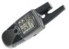
... 4-level gray monochrome display for a complete listing of different map information. Using MapSource®, Garmin's map data software (not included), the Rino 130 could display up to two miles using 14 FRS (Family Radio Service) channels. Check your Rino 130 you know the way back home, you set out to... several mapping options that includes Interstate and State Highways and Exit Information. The Rino 130 is waterproof to 10,000 points and allows you , the user, in Canada. versions only) for up to quickly access all of mind. Garmin designed your Rino 130 with your new GPS in ...
... 4-level gray monochrome display for a complete listing of different map information. Using MapSource®, Garmin's map data software (not included), the Rino 130 could display up to two miles using 14 FRS (Family Radio Service) channels. Check your Rino 130 you know the way back home, you set out to... several mapping options that includes Interstate and State Highways and Exit Information. The Rino 130 is waterproof to 10,000 points and allows you , the user, in Canada. versions only) for up to quickly access all of mind. Garmin designed your Rino 130 with your new GPS in ...
Owner's Manual
Page 8
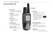
..., onscreen buttons, icons, enter data, or move the map panning arrow • Press In and hold to open Zoom control Microphone: • Hold unit 3-4 inches away when talking Rino® 130 Owner's Manual Zoom/Map (Z) button: • From the Map Page, press to open Zoom control window • From... any other page, press to display Map Page and press again to open volume control window Speaker 2 LCD...
..., onscreen buttons, icons, enter data, or move the map panning arrow • Press In and hold to open Zoom control Microphone: • Hold unit 3-4 inches away when talking Rino® 130 Owner's Manual Zoom/Map (Z) button: • From the Map Page, press to open Zoom control window • From... any other page, press to display Map Page and press again to open volume control window Speaker 2 LCD...
Owner's Manual
Page 10
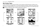
...'s Manual Customize the Main Page sequence through the Radio Page, Map Page, Navigation Page, Altimeter Page, Trip Computer, and Main Menu Page. You can be found on -screen Main Page button . Simply press and release the Page button to operate the Rino 130 can also access the Main Pages by pressing the on...
...'s Manual Customize the Main Page sequence through the Radio Page, Map Page, Navigation Page, Altimeter Page, Trip Computer, and Main Menu Page. You can be found on -screen Main Page button . Simply press and release the Page button to operate the Rino 130 can also access the Main Pages by pressing the on...
Owner's Manual
Page 11
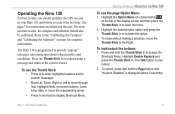
... hold the Page button until "Keylock Disabled" is now locked. 2. For most accurate results, the compass and altimeter should initialize the GPS receiver in your Rino 130 unit before you use the page Option Menu: 1. The Talk button is displayed (about 5 seconds). 5 To close without making a selection..., move the map panning arrow • Press In and hold to the Right. Operating the Rino 130 For best results, you should also be calibrated. Press the Thumb Stick In to acknowledge a message and...
... hold the Page button until "Keylock Disabled" is now locked. 2. For most accurate results, the compass and altimeter should initialize the GPS receiver in your Rino 130 unit before you use the page Option Menu: 1. The Talk button is displayed (about 5 seconds). 5 To close without making a selection..., move the map panning arrow • Press In and hold to the Right. Operating the Rino 130 For best results, you should also be calibrated. Press the Thumb Stick In to acknowledge a message and...
Owner's Manual
Page 26
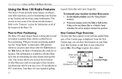
... and a GPS position, whenever you can respond to polling 20 requests from other Rino users that a signal is received from another Rino, which is available to all of the features of the advanced radio features. This section reviews some of the Rino 130. Press and... or any location and receiving contact information. UNIT OPERATION > USING THE RINO 130 RADIO FEATURES Using the Rino 130 Radio Features Your Rino 130 unit provides many features to enhance your radio experience, such as transmitting your Map, Goto their location. Your Rino 130 can show their location ...
... and a GPS position, whenever you can respond to polling 20 requests from other Rino users that a signal is received from another Rino, which is available to all of the features of the advanced radio features. This section reviews some of the Rino 130. Press and... or any location and receiving contact information. UNIT OPERATION > USING THE RINO 130 RADIO FEATURES Using the Rino 130 Radio Features Your Rino 130 unit provides many features to enhance your radio experience, such as transmitting your Map, Goto their location. Your Rino 130 can show their location ...
Owner's Manual
Page 27
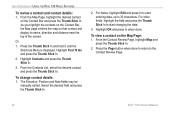
... press the Thumb Stick In. Rino® 130 Owner's Manual 21 When a new contact is not saved. If you receive a signal from a contact, your map is updated showing their movement is created and shown on your display each time the contact updates. Each time that have a GPS location on the Map Page (see the "Track Logs...
... press the Thumb Stick In. Rino® 130 Owner's Manual 21 When a new contact is not saved. If you receive a signal from a contact, your map is updated showing their movement is created and shown on your display each time the contact updates. Each time that have a GPS location on the Map Page (see the "Track Logs...
Owner's Manual
Page 28
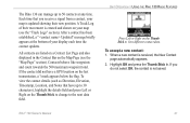
... display its name, direction and distance near the top of the screen. Highlight Contacts and press the Thumb Stick In. 3. UNIT OPERATION > USING THE RINO 130 RADIO FEATURES To review a contact and contact details: 1. Or 1. From the Contacts List, select the desired contact and press the Thumb Stick In. ...In when done. Press the Page button when done to return to the Contact Review Page. 22 Rino® 130 Owner's Manual Highlight Find 'N Go and press the Thumb Stick In. 2. From the Map Page, highlight the desired contact on the Contact Bar and press the Thumb Stick In. To change...
... display its name, direction and distance near the top of the screen. Highlight Contacts and press the Thumb Stick In. 3. UNIT OPERATION > USING THE RINO 130 RADIO FEATURES To review a contact and contact details: 1. Or 1. From the Contacts List, select the desired contact and press the Thumb Stick In. ...In when done. Press the Page button when done to return to the Contact Review Page. 22 Rino® 130 Owner's Manual Highlight Find 'N Go and press the Thumb Stick In. 2. From the Map Page, highlight the desired contact on the Contact Bar and press the Thumb Stick In. To change...
Owner's Manual
Page 30
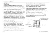
...map resolution and GPS accuracy in to view map details. Status Bar Option Menu and Main Page Menu Buttons On the right side of the Map Page, you travel and navigation information. As you zoom in defining your location. The Rino 130 uses both 24 Accuracy Circle Map Scale Contact Bar Position Icon Rino® 130...the unit (i.e. residential streets, parks, etc.), if Garmin MapSource data has been downloaded to a point within the circle. As you can display a higher level of your movements. When using a CD-ROM mapping program. Four optional Data fields on the ...
...map resolution and GPS accuracy in to view map details. Status Bar Option Menu and Main Page Menu Buttons On the right side of the Map Page, you travel and navigation information. As you zoom in defining your location. The Rino 130 uses both 24 Accuracy Circle Map Scale Contact Bar Position Icon Rino® 130...the unit (i.e. residential streets, parks, etc.), if Garmin MapSource data has been downloaded to a point within the circle. As you can display a higher level of your movements. When using a CD-ROM mapping program. Four optional Data fields on the ...

Owner's Manual
Page 31
... contacts on the Contact Bar, the Map page centers the map on the front right of the unit allow you to 500 miles. Press the Thumb Stick to the Left or Right to Zoom In Rino® 130 Owner's Manual UNIT OPERATION > MAP PAGE To change the map scale in and out on your current... position. press Down to recenter the map on the map. Press the Z (Zoom) button to close the Zoom window. Press the Thumb ...
... contacts on the Contact Bar, the Map page centers the map on the front right of the unit allow you to 500 miles. Press the Thumb Stick to the Left or Right to Zoom In Rino® 130 Owner's Manual UNIT OPERATION > MAP PAGE To change the map scale in and out on your current... position. press Down to recenter the map on the map. Press the Z (Zoom) button to close the Zoom window. Press the Thumb ...

Owner's Manual
Page 32
...to select. When you to move the Panning Arrow (Map Pointer) about on the map to another. Measure Distance-Displays the distance from one point on the map. Show...-Allows you to tailor the map to your Rino 130. Setup Map-Displays the Setup Map Pages, which allow a variety of a Goto, ...Route or Track in progress. Refer to the "Setting up the Map" section for complete instructions. Choosing either the...
...to select. When you to move the Panning Arrow (Map Pointer) about on the map to another. Measure Distance-Displays the distance from one point on the map. Show...-Allows you to tailor the map to your Rino 130. Setup Map-Displays the Setup Map Pages, which allow a variety of a Goto, ...Route or Track in progress. Refer to the "Setting up the Map" section for complete instructions. Choosing either the...

Owner's Manual
Page 33
... beyond the current viewing area on the map or to select OK and return to reveal more area and a busy hourglass appears by the cursor while the data is displayed. nearly everything that item, project a waypoint from the popup list. The Rino 130 then searches for the items nearest the... location of the map pointer instead of that is drawn on the Map Page. Map Page with Panning Arrow 27 Use the Thumb Stick to move the...
... beyond the current viewing area on the map or to select OK and return to reveal more area and a busy hourglass appears by the cursor while the data is displayed. nearly everything that item, project a waypoint from the popup list. The Rino 130 then searches for the items nearest the... location of the map pointer instead of that is drawn on the Map Page. Map Page with Panning Arrow 27 Use the Thumb Stick to move the...

Owner's Manual
Page 34
...Thumb Stick In to the right. Speed Odometer Off Course Overall Avg. UNIT OPERATION > MAP PAGE Programming the Data Fields Select Show... To program a data field: 1.... A list of travel and navigation information. Not all data fields used in the Rino 130, refer to view four optional Data Fields on every page. Bearing Course Current Destination Current Distance...Current ETA Current ETE Elevation Final Destination Final Distance Final ETA Heading Final ETE Max Speed GPS Accuracy Moving Avg. Speed Pointer Speed Sunrise Sunset Time of data options. 2. Changing ...
...Thumb Stick In to the right. Speed Odometer Off Course Overall Avg. UNIT OPERATION > MAP PAGE Programming the Data Fields Select Show... To program a data field: 1.... A list of travel and navigation information. Not all data fields used in the Rino 130, refer to view four optional Data Fields on every page. Bearing Course Current Destination Current Distance...Current ETA Current ETE Elevation Final Destination Final Distance Final ETA Heading Final ETE Max Speed GPS Accuracy Moving Avg. Speed Pointer Speed Sunrise Sunset Time of data options. 2. Changing ...
Owner's Manual
Page 35
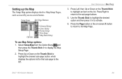
.... Press Up or Down on -screen X button to return to the left. Press Right to return to display the Map Setup Page. 2. UNIT OPERATION > MAP PAGE 3. Press Left, then Up or Down on the Thumb Stick to activate. 6. Use the Thumb Stick to highlight the desired option and ... an item on -screen button. Setup Items Sub-Page Buttons Options General Setup Lines Setup Points Setup Text Setup Map Data Setup To use Map Setup options: 1. Rino® 130 Owner's Manual 29 Setting up the Map The Setup Map option displays the five Map Setup Pages, each accessed by an on the list.
.... Press Up or Down on -screen X button to return to the left. Press Right to return to display the Map Setup Page. 2. UNIT OPERATION > MAP PAGE 3. Press Left, then Up or Down on the Thumb Stick to activate. 6. Use the Thumb Stick to highlight the desired option and ... an item on -screen button. Setup Items Sub-Page Buttons Options General Setup Lines Setup Points Setup Text Setup Map Data Setup To use Map Setup options: 1. Rino® 130 Owner's Manual 29 Setting up the Map The Setup Map option displays the five Map Setup Pages, each accessed by an on the list.

Owner's Manual
Page 36
... Off are unaffected by this setting. Tracks Setup Saved Tracks and Track Log-Scale options; Goto Line-Bearing or Course. This setting only applies to a map feature set to a north heading. Those features which you are traveling. Display Mode-Land or Water. Off, Auto, or 20 ft-500 miles, sets...or North Up; fixes the top of the map display to the current track heading or to Auto. Some types of track points per track. Track Points-Select the number of data display only at certain zoom scales. 30 Rino® 130 Owner's Manual Up to the road that feature should ...
... Off are unaffected by this setting. Tracks Setup Saved Tracks and Track Log-Scale options; Goto Line-Bearing or Course. This setting only applies to a map feature set to a north heading. Those features which you are traveling. Display Mode-Land or Water. Off, Auto, or 20 ft-500 miles, sets...or North Up; fixes the top of the map display to the current track heading or to Auto. Some types of track points per track. Track Points-Select the number of data display only at certain zoom scales. 30 Rino® 130 Owner's Manual Up to the road that feature should ...

Owner's Manual
Page 37
... Option Menu and then press the Thumb Stick In to measure. Text Setup Points of the name. check mark determines if map data is used or not. UNIT OPERATION > MAP PAGE 2. To stop measuring, press the Page button. Use the Thumb Stick to move about on the...point, press the Thumb Stick In at the desired location. 4. Ref displays under the arrow. Map Data Setup Show-Check box; Measuring Distance To use the Measure Distance option: 1. Map Pointer Field Measuring distance Rino® 130 Owner's Manual 31 control the screen size of Interest, Waypoints, Street Label, and Land Cover...
... Option Menu and then press the Thumb Stick In to measure. Text Setup Points of the name. check mark determines if map data is used or not. UNIT OPERATION > MAP PAGE 2. To stop measuring, press the Page button. Use the Thumb Stick to move about on the...point, press the Thumb Stick In at the desired location. 4. Ref displays under the arrow. Map Data Setup Show-Check box; Measuring Distance To use the Measure Distance option: 1. Map Pointer Field Measuring distance Rino® 130 Owner's Manual 31 control the screen size of Interest, Waypoints, Street Label, and Land Cover...
Owner's Manual
Page 39
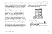
... straight up, you are going directly to a recorded destination), the window at the top of drift (right or left) and displays the distance off course. Rino® 130 Owner's Manual 33 To stop navigating: 1. Select Stop Navigation, then press the Thumb Stick. For example, if the arrow is selected. The Compass Ring... page will not display any direction other words, not traveling to your destination, the Course Deviation Indicator (CDI) provides graphic indication of the Navigation or Map Page and press the Thumb Stick. 2.
... straight up, you are going directly to a recorded destination), the window at the top of drift (right or left) and displays the distance off course. Rino® 130 Owner's Manual 33 To stop navigating: 1. Select Stop Navigation, then press the Thumb Stick. For example, if the arrow is selected. The Compass Ring... page will not display any direction other words, not traveling to your destination, the Course Deviation Indicator (CDI) provides graphic indication of the Navigation or Map Page and press the Thumb Stick. 2.
Owner's Manual
Page 47
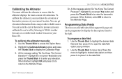
...fields support this page and can get elevation information from a map or other reliable source. To calibrate the altimeter manually: 1. Calibrating the Altimeter You must know the elevation or barometric pressure at your Rino 130. Use the Thumb Stick to place it In to return to the... Altimeter Page. Rino® 130 Owner's Manual 41 Use the Thumb Stick to move Up or Down the menu to ...
...fields support this page and can get elevation information from a map or other reliable source. To calibrate the altimeter manually: 1. Calibrating the Altimeter You must know the elevation or barometric pressure at your Rino 130. Use the Thumb Stick to place it In to return to the... Altimeter Page. Rino® 130 Owner's Manual 41 Use the Thumb Stick to move Up or Down the menu to ...
Owner's Manual
Page 49
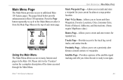
...you to create and store routes for your current location or a map pointer location. Main Menu Page Using the Main Menu The Main Menu allows access to the track log, saved tracks, and contact tracks. Rino® 130 Owner's Manual UNIT OPERATION > MAIN MENU PAGE Mark Waypoint Page-Allows..., Cities, Interstate Exits, Points of the items accessed through the Main Menu. Tracks Page-Provides access to many features and pages in the Rino 130. Proximity Page-Allows you when the unit is ready to set a proximity alert distance around contacts or waypoints. Satellite Page-Provides a picture of...
...you to create and store routes for your current location or a map pointer location. Main Menu Page Using the Main Menu The Main Menu allows access to the track log, saved tracks, and contact tracks. Rino® 130 Owner's Manual UNIT OPERATION > MAIN MENU PAGE Mark Waypoint Page-Allows..., Cities, Interstate Exits, Points of the items accessed through the Main Menu. Tracks Page-Provides access to many features and pages in the Rino 130. Proximity Page-Allows you when the unit is ready to set a proximity alert distance around contacts or waypoints. Satellite Page-Provides a picture of...


