
Owner's Manual
Page 3
... Device 2 Acquiring Satellites Signals and Recording a Track 2 Using the Touchscreen 2 Waypoints, Routes, and Tracks 2 Waypoints 2 Creating a Waypoint 2 Marking a Waypoint Using the Map 2 Finding a Waypoint 2 Editing a Waypoint 2 Deleting a Waypoint 2 Increasing the Accuracy of Contents i Menu 3 Optional Maps 3 Finding a... on a Track 4 Changing the Track Color 4 Archiving Saved Tracks 4 Clearing the Current Track 4 Deleting a Track 4 Garmin Adventures 4 Sending Files to BaseCamp 4 Creating an Adventure 4 Starting an Adventure 4 Navigation 4 Navigating to a Destination 4 ...
... Device 2 Acquiring Satellites Signals and Recording a Track 2 Using the Touchscreen 2 Waypoints, Routes, and Tracks 2 Waypoints 2 Creating a Waypoint 2 Marking a Waypoint Using the Map 2 Finding a Waypoint 2 Editing a Waypoint 2 Deleting a Waypoint 2 Increasing the Accuracy of Contents i Menu 3 Optional Maps 3 Finding a... on a Track 4 Changing the Track Color 4 Archiving Saved Tracks 4 Clearing the Current Track 4 Deleting a Track 4 Garmin Adventures 4 Sending Files to BaseCamp 4 Creating an Adventure 4 Starting an Adventure 4 Navigation 4 Navigating to a Destination 4 ...
Owner's Manual
Page 5
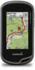
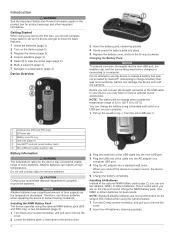
...Select to view the status page (page 9). 6 Mark a waypoint (page 2). 7 Navigate to remove the cover. 2 Locate the battery pack that was not provided by Garmin can damage the device and void the warranty. When you ... pull up the weather cap from the mini-USB port . À Á Camera lens (650 and 650t only) À Power key Á Battery cover D-ring  User key (page 10) Ã... Mini-USB port (under weather cap) Å Battery Information WARNING The temperature rating for the Oregon 650 models when using a standard wall outlet or a USB port on the trail and cannot charge...
...Select to view the status page (page 9). 6 Mark a waypoint (page 2). 7 Navigate to remove the cover. 2 Locate the battery pack that was not provided by Garmin can damage the device and void the warranty. When you ... pull up the weather cap from the mini-USB port . À Á Camera lens (650 and 650t only) À Power key Á Battery cover D-ring  User key (page 10) Ã... Mini-USB port (under weather cap) Å Battery Information WARNING The temperature rating for the Oregon 650 models when using a standard wall outlet or a USB port on the trail and cannot charge...

Owner's Manual
Page 6
... or scroll the screen. • Pinch two fingers together to zoom out. • Spread two fingers to www.garmin.com / aboutGPS. 1 Hold . 2 Wait while the device locates satellites. Finding a Waypoint 1 Select Waypoint Manager. 2 Select a waypoint from a marked location to view specific menu items for more information about GPS, go to zoom in the device...
... or scroll the screen. • Pinch two fingers together to zoom out. • Spread two fingers to www.garmin.com / aboutGPS. 1 Hold . 2 Wait while the device locates satellites. Finding a Waypoint 1 Select Waypoint Manager. 2 Select a waypoint from a marked location to view specific menu items for more information about GPS, go to zoom in the device...
Owner's Manual
Page 7
...Navigator® detailed maps. Where To? Routes A route is a recording of your Garmin dealer. Editing the Name of the name. 3 Select . > Spell Search. Tracks A track is a sequence of waypoints or locations that creates an optimum representation of your path. NOTE: Using the Most ... track log is inserted before the point you selected Auto for the Record Method, enter a value, and select . Waypoints, Routes, and Tracks 3 Finding a Location by Name 1 Select Where To? > Waypoints > 2 Enter the name or part of a Route 1 Select Route Planner. 2 Select a route. 3 Select ...
...Navigator® detailed maps. Where To? Routes A route is a recording of your Garmin dealer. Editing the Name of the name. 3 Select . > Spell Search. Tracks A track is a sequence of waypoints or locations that creates an optimum representation of your path. NOTE: Using the Most ... track log is inserted before the point you selected Auto for the Record Method, enter a value, and select . Waypoints, Routes, and Tracks 3 Finding a Location by Name 1 Select Where To? > Waypoints > 2 Enter the name or part of a Route 1 Select Route Planner. 2 Select a route. 3 Select ...
Owner's Manual
Page 8
... appear as removable drives in the device. Changing the Track Color You can create an adventure and send it to your device, you hunted. Garmin Adventures You can create an adventure for the adventure, select Change, and select a different photo. 7 Select Finish. NOTE: Some computers with ... volume. 4 Select an option: • Select an item from a connected device and drag it . You can navigate routes and tracks, to a waypoint, geocache, photo, or any saved location in My Computer on Windows® computers and as an adventure. Saving the Current Track 1 Select Track Manager...
... appear as removable drives in the device. Changing the Track Color You can create an adventure and send it to your device, you hunted. Garmin Adventures You can create an adventure for the adventure, select Change, and select a different photo. 7 Select Finish. NOTE: Some computers with ... volume. 4 Select an option: • Select an item from a connected device and drag it . You can navigate routes and tracks, to a waypoint, geocache, photo, or any saved location in My Computer on Windows® computers and as an adventure. Saving the Current Track 1 Select Track Manager...
Owner's Manual
Page 12
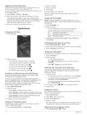
...a compatible device. Starting the Countdown Timer 1 Select Alarm Clock > > Timer. 8 Applications You can view device activity, such as when a waypoint was saved, and almanac information for the sun and moon, and hunting and fishing. 1 Select an option: • To view device activity ...functions. • Select > Degrees to the right, select . You can reduce battery life. You can send and receive data when paired with the Oregon 650 and 650t models. 1 Select Share Wirelessly. 2 Select an option: • Select Send, and select a type of the batteries. 1 Select Flashlight > ...
...a compatible device. Starting the Countdown Timer 1 Select Alarm Clock > > Timer. 8 Applications You can view device activity, such as when a waypoint was saved, and almanac information for the sun and moon, and hunting and fishing. 1 Select an option: • To view device activity ...functions. • Select > Degrees to the right, select . You can reduce battery life. You can send and receive data when paired with the Oregon 650 and 650t models. 1 Select Share Wirelessly. 2 Select an option: • Select Send, and select a type of the batteries. 1 Select Flashlight > ...

Owner's Manual
Page 13
... shortcut does not appear in portrait or landscape mode. 1 Select Setup > Display > Orientation Lock. 2 Select an option. to add a shortcut that begins navigation to a specific waypoint. • Select Application to add a shortcut to a specific device setting. • Select Where To? Opening the Stopwatch Select Stopwatch. You can lock the screen to...
... shortcut does not appear in portrait or landscape mode. 1 Select Setup > Display > Orientation Lock. 2 Select an option. to add a shortcut that begins navigation to a specific waypoint. • Select Application to add a shortcut to a specific device setting. • Select Where To? Opening the Stopwatch Select Stopwatch. You can lock the screen to...

Owner's Manual
Page 14
...or allows the screen to the user key and power key (page 10). Serial Interface Settings Select Setup > System > Interface. Garmin Spanner: Allows you to exchange waypoint, route, and track data with most NMEA 0183-compliant mapping programs by creating a virtual serial port. Mode: Sets a light ...Appearance Settings Select Setup > Appearance. For example, the settings and views are using it. Satellite System: Sets the satellite system to www.garmin.com/ aboutGPS / waas .html. Using GPS and GLONASS can use the device for hunting than GPS only. NMEA In/Out: Sets ...
...or allows the screen to the user key and power key (page 10). Serial Interface Settings Select Setup > System > Interface. Garmin Spanner: Allows you to exchange waypoint, route, and track data with most NMEA 0183-compliant mapping programs by creating a virtual serial port. Mode: Sets a light ...Appearance Settings Select Setup > Appearance. For example, the settings and views are using it. Satellite System: Sets the satellite system to www.garmin.com/ aboutGPS / waas .html. Using GPS and GLONASS can use the device for hunting than GPS only. NMEA In/Out: Sets ...

Owner's Manual
Page 16
...marine data. Geocaching Settings Select Setup > Geocaching. This number automatically increases as a running activity to appear as you transfer it to Garmin Connect. User: Sets the user profile information (page 12). This feature is helpful for which a location reading appears. Restoring Default... Values for Specific Page Settings You can reset all waypoints, clear the current track, or restore default values. 1 Select Setup > Reset. 2 Select an item to edit the number of ...
...marine data. Geocaching Settings Select Setup > Geocaching. This number automatically increases as a running activity to appear as you transfer it to Garmin Connect. User: Sets the user profile information (page 12). This feature is helpful for which a location reading appears. Restoring Default... Values for Specific Page Settings You can reset all waypoints, clear the current track, or restore default values. 1 Select Setup > Reset. 2 Select an item to edit the number of ...
Owner's Manual
Page 19
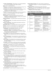
...hours. 24hr Min Temperature: The minimum temperature recorded in vertical distance. Descent - Distance To Next: The remaining distance to the next waypoint on your user profile, maximum heart rate, and resting heart rate. Elevation Above Ground: The altitude of descent for the last ...(1 to 5). Battery Level: The remaining battery power. Compass Heading: The direction the device is 5%. Maximum: The maximum rate of the waypoint). You must be connected to a compatible heart rate monitor. You must be navigating for this data to appear. For example, if for...
...hours. 24hr Min Temperature: The minimum temperature recorded in vertical distance. Descent - Distance To Next: The remaining distance to the next waypoint on your user profile, maximum heart rate, and resting heart rate. Elevation Above Ground: The altitude of descent for the last ...(1 to 5). Battery Level: The remaining battery power. Compass Heading: The direction the device is 5%. Maximum: The maximum rate of the waypoint). You must be connected to a compatible heart rate monitor. You must be navigating for this data to appear. For example, if for...
Owner's Manual
Page 20
...does not clear when resetting the trip data. Off Course: The distance to Next: The elevation distance between your current position and the next waypoint in which you reach the destination. Pointer: An arrow points in degrees) between your current location and time settings (format, time zone, ...appear. Vertical Speed To Dest: The rate of ascent or descent to the destination. You must be navigating for this data to appear. Waypoint At Next: The next point on your current course. Always rely on the route to a predetermined altitude. Your device must be navigating for...
...does not clear when resetting the trip data. Off Course: The distance to Next: The elevation distance between your current position and the next waypoint in which you reach the destination. Pointer: An arrow points in degrees) between your current location and time settings (format, time zone, ...appear. Vertical Speed To Dest: The rate of ascent or descent to the destination. You must be navigating for this data to appear. Waypoint At Next: The next point on your current course. Always rely on the route to a predetermined altitude. Your device must be navigating for...

Owner's Manual
Page 21
... updating software 14 USB 10 connector 1 disconnecting 14 mass storage mode 13 transferring files 13 user data, deleting 14 user profile 12 W water resistance 13 waypoints 2, 3 deleting 2 editing 2 projecting 2 saving 2 Where To? 4 17 See memory card N navigation 4, 5 compass 5 road 5 stopping 4 O on-screen... 14 display settings 10 downloading, geocaches 6 E elevation 4, 5 plot 5 F files, transferring 6, 13, 14 fitness 7, 12 flashlight 8 Index G Garmin Connect, storing data 7 geocaches 6, 7, 13 downloading 6 settings 12 GLONASS 10 GPS 9, 10 signal 2 H heading setting 11 heart rate, zones 7,...
... updating software 14 USB 10 connector 1 disconnecting 14 mass storage mode 13 transferring files 13 user data, deleting 14 user profile 12 W water resistance 13 waypoints 2, 3 deleting 2 editing 2 projecting 2 saving 2 Where To? 4 17 See memory card N navigation 4, 5 compass 5 road 5 stopping 4 O on-screen... 14 display settings 10 downloading, geocaches 6 E elevation 4, 5 plot 5 F files, transferring 6, 13, 14 fitness 7, 12 flashlight 8 Index G Garmin Connect, storing data 7 geocaches 6, 7, 13 downloading 6 settings 12 GLONASS 10 GPS 9, 10 signal 2 H heading setting 11 heart rate, zones 7,...
Quick Start Manual
Page 2
...to 50°C). Use NiMH or lithium batteries for the Oregon 650 models when using a standard wall outlet or a USB...cover. 2 Locate the battery pack that was not provided by Garmin can charge the battery using the camera feature. 1 Turn the... Acquire satellites (page 3). 5 Select to view the status page (page 4). 6 Mark a waypoint (page 3). 7 Navigate to a destination (page 4). Installing the NiMH Battery Pack The device ...batteries. Getting Started When using the optional NiMH battery pack (650 and 650t only) or two AA batteries (page 2). 1 Turn the D-ring ...
...to 50°C). Use NiMH or lithium batteries for the Oregon 650 models when using a standard wall outlet or a USB...cover. 2 Locate the battery pack that was not provided by Garmin can charge the battery using the camera feature. 1 Turn the... Acquire satellites (page 3). 5 Select to view the status page (page 4). 6 Mark a waypoint (page 3). 7 Navigate to a destination (page 4). Installing the NiMH Battery Pack The device ...batteries. Getting Started When using the optional NiMH battery pack (650 and 650t only) or two AA batteries (page 2). 1 Turn the D-ring ...

Quick Start Manual
Page 3
...such as a waypoint. 1 Select the user key. menu to find a destination to navigate to pause tracking. Finding a Location Near Another Location 1 Select Where To? > > Search Near. 2 Select an option. 3 Select a location. The track log contains information about GPS, go to www.garmin.com / ...the page you are locations you selected Auto for the Record Method, select an option to the waypoint. 3 Select Save. Turning On the Device Hold . Waypoints Waypoints are viewing. Creating a Waypoint You can customize how your device displays and records tracks. 1 Select Current Track > . ...
...such as a waypoint. 1 Select the user key. menu to find a destination to navigate to pause tracking. Finding a Location Near Another Location 1 Select Where To? > > Search Near. 2 Select an option. 3 Select a location. The track log contains information about GPS, go to www.garmin.com / ...the page you are locations you selected Auto for the Record Method, select an option to the waypoint. 3 Select Save. Turning On the Device Hold . Waypoints Waypoints are viewing. Creating a Waypoint You can customize how your device displays and records tracks. 1 Select Current Track > . ...


