Garmin Montana 600 Support Question
Garmin Montana 600 Support Question
Find answers below for this question about Garmin Montana 600.Need a Garmin Montana 600 manual? We have 4 online manuals for this item!
Question posted by CrinerJames on February 21st, 2012
Montana 650t - Route Waypoints
Unit has version 3.9 firmware. Numerous route waypoint names are replaced with the date the waypoint was created. Shows the date when navating instead of waypoint name.
Current Answers
Related Garmin Montana 600 Manual Pages
Owner's Manual - Page 3
... an Area���29 Using the Calculator 29
i Menu 10 Routes 11 Tracks 13 Adventures 15
Montana 600 Series Owner's Manual
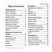
Table of Contents
Navigation 16 Navigating to a Destination ...Using the Touchscreen 5 Rotating the Screen 6 Turning On the Backlight 6 Adjusting the Volume 7 Profiles 7
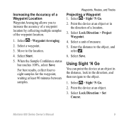
Waypoints, Routes, and Tracks 8 Waypoints 8 Using Sight 'N Go 9 Where To?
Owner's Manual - Page 5
... the device (page 5).
4. Mark a waypoint (page 8).
7. Record a track (page 13).
9. Create a route (page 11).
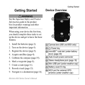
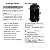
8. Acquire satellites (page ...➊
➌
➍
➎ ➐➏
➑
➊ Camera lens (650 and 650t only) ➋ Power key ➌ microSD™ card slot (under battery
door) (page 49) ...GPS
antenna (under weather cap)
Montana 600 Series Owner's Manual
1
Owner's Manual - Page 12
...Select > Delete.
8
Montana 600 Series Owner's Manual
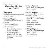
Creating a Waypoint You can edit a waypoint, you must create a waypoint.
1. Select > Waypoint Manager. 2.
Select Mark Waypoint. 2. Finding a Waypoint 1. Deleting a Waypoint 1. Waypoints, Routes, and Tracks
Waypoints, Routes, and Tracks
Waypoints
Waypoints are locations you can save the waypoint without changes, select Save...
Owner's Manual - Page 13
Select Start.
5.
Waypoints, Routes, and Tracks
Projecting a Waypoint 1. Select a unit of the waypoint location.
1. Enter the distance to the location.
4. Point the device at an object in the distance, lock in the direction of a location.
3.
Select a waypoint.
3. Select > Sight 'N Go.
2. Using Sight 'N Go
You can point the device at an object.
3. Montana 600 Series Owner's Manual
9...
Owner's Manual - Page 14
...additional points of the name.
5. Select a category.
3. Finding a Location Near Another Location 1. Select Where To? > > Search
Near.
2. Waypoints, Routes, and Tracks
Where To? Finding a Location by Name Depending on the maps..., go to . Select .
4. If necessary, select a location.
10
Montana 600 Series Owner's Manual Menu
You can use the Where To? Additional Maps You can use additional...
Owner's Manual - Page 15
...Select a category. 3.
Select the city. 5. Select > Route Planner. 2.
Montana 600 Series Owner's Manual
11 Waypoints, Routes, and Tracks
Creating a Route 1. Repeat steps 2-4 until the route is a sequence of a Route 1. Select Change Name. 4. Enter the city or postal code. Select > Route Planner >
Create Route > Select First Point. 2. Select to search for addresses...
Owner's Manual - Page 16
Select a point.
5. Select Delete Route. While navigating a route, select
> Active Route. 2. Select a route. 3. Select Reverse Route.
12
Montana 600 Series Owner's Manual Waypoints, Routes, and Tracks
Editing a Route 1.
Deleting a Route 1. Select a point in the route to save the route. Select an option:
• To view the point on the map, select Review.
• To change the order...
Owner's Manual - Page 17
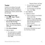
...; Enter a time or distance, and select . As you select Record, Show On Map, a line on , a track log is a recording of your path.
Montana 600 Series Owner's Manual
13 The track log contains information about points along the recorded path, including time, location, and elevation for each point. Tracks
A track is created. Recording Track Logs 1.
Owner's Manual - Page 18
... the information bar on the
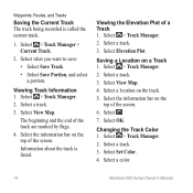
top of a Track 1. Select View Map. 4.
Select a color.
14
Montana 600 Series Owner's Manual Viewing Track Information 1. The beginning and the end of the screen.
Select > Track Manager.... Changing the Track Color 1. Select a track. 3. Waypoints, Routes, and Tracks
Saving the Current Track The track being recorded is listed. Select > Track Manager > ...
Owner's Manual - Page 19
Deleting a Track 1. Montana 600 Series Owner's Manual
Waypoints, Routes, and Tracks
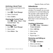
Adventures
Group related items together as an adventure. ...3. Clearing the Current Track
Select > Setup > Reset > Clear Current Track > Yes. Creating an Adventure 1. Select Use.
5.
You can create an adventure for your adventures. Select an adventure.
3. Reviewing and Editing an Adventure 1. The...
Owner's Manual - Page 20
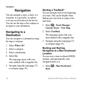
... to a destination using the map or compass.
1. The map page opens with your route marked with a magenta line.
3. Select > Man Overboard > Start.
16
Montana 600 Series Owner's Manual
Marking and Starting Navigation to a Man Overboard Location You can navigate a route, a track, to a waypoint, to a geocache, to a photo, or to any saved location in the device...
Owner's Manual - Page 27
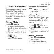
... camera (page 23) and photos you take photos with the Montana 650 and 650t. Hold to the device (page 50).
1. Viewing a Slideshow 1. Montana 600 Series Owner's Manual
23 You can navigate to zoom in the photo information. Select > Photo Viewer.
2. to the location like a waypoint. Camera and Photos
You can take a photo, the geographic location...
Owner's Manual - Page 32
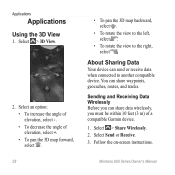
... To decrease the angle of a compatible Garmin device.
1. Follow the on-screen instructions.
Montana 600 Series Owner's Manual Select > 3D View.
2. Sending and Receiving Data Wirelessly Before you ...the view to another compatible device. About Sharing Data
Your device can share waypoints, geocaches, routes, and tracks. Select Send or Receive. 3. Applications
Applications
Using the 3D...
Owner's Manual - Page 39
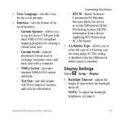
... you to use the device USB port with most NMEA 0183-compliant mapping programs by creating a virtual serial port.
◦◦ Garmin Serial-Garmin proprietary format used to select the type of AA battery you to exchange waypoint, route, and track data with a computer.
◦◦ NMEA In/Out-provides standard NMEA 0183...
Owner's Manual - Page 59
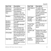
.... The remaining distance to the next waypoint on the route.
The estimated time of your final destination. The ratio of the GPS signal.
GPS Signal Strength Heading
**Heart Rate (heart rate monitor required) Location (lat/ lon)
Location (selected)
Description
The glide ratio required to descend from your final destination. Montana 600 Series Owner's Manual
55 The...
Owner's Manual - Page 60
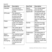
... waypoint or turn. Your average speed
Overall Avg. since last reset. Sunrise
The time of speed at which you are moving since last reset. The distance to acquire data
(page 52).
56
Montana 600....
Speed Limit
The reported speed limit for all maps and areas.
Always rely on your GPS position. Requires
a connection to
a NMEA 0183
temperature-capable
device to the left or the...
Owner's Manual - Page 61
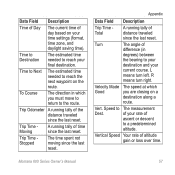
...turn left. Velocity Made The speed at which you are closing on a
destination along a
route.
Turn
The angle of
difference (in which
Good
you must move to return to The measurement...needed to reach the next waypoint on your final destination.
Trip Time Stopped
The time spent not moving since the last reset.
Speed to the route. Montana 600 Series Owner's Manual
...
Owner's Manual - Page 66
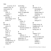
Index
accessories 52, 53 countdown timer 30 course pointer 20 creating
routes 11 waypoints 8 customizing data fields 17 device settings 34-44 profiles 34
D data fields 33
options 54 deleting
files 51 profiles 34 routes 12 tracks 15 waypoints 8 display backlight 6 backlight timeout 35 screen capture 35 settings 35
62
downloading geocaches 25 photos 24 software...
Owner's Manual - Page 68
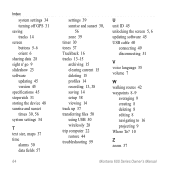
...50 using USB 50 wirelessly 28 trip computer 22 restore 44 troubleshooting 59
U unit ID 45 unlocking the screen 5, 6 updating software 45 USB cable 60
connecting 49 disconnecting 51
V voice language 35 volume 7
W walking routes 42 waypoints 8-9
averaging 9 creating 8 deleting 8 editing 8 navigating to 16 projecting 9 Where To? 10
Z zoom 37
Montana 600 Series Owner's Manual
Quick Start Manual - Page 2
...
➌
➍
➎ ➐➏
➑
➊ Camera lens (650 and 650t only)
➋ Power key ➌ microSD™ card slot (under battery
door) ➍ ...
Montana 600 Series Quick Start Manual Register the device (page 5).
4.
Turn on the device (page 5).
3. Record a track (page 8).
9. Acquire satellites (page 5).
5. Mark a waypoint (page 7).
7. Create a route ...
Similar Questions


What Is Horizontal And Vertical Accuracy Of A Garmin Montana 650t Gps
(Posted by morfkm 10 years ago)
Reposition A Waypoint On Garmin Montana 600?
How do I reposition a waypoint to my current location on Garmin Montana 600?
How do I reposition a waypoint to my current location on Garmin Montana 600?
(Posted by mikedavis 12 years ago)