
Important Safety and Product Information
Page 2
... navigation sources, including road signs, road closures, road conditions, traffic congestion, weather conditions, and other factors that follow roads. The Garmin device is not a replacement for your activity. Do not follow route suggestions if they suggest an illegal course or would place the ...and conditions. • Always be fully aware of the road ➊ or interfere with California's Proposition 65. Battery Warnings Your GPS device uses user-replaceable batteries. Do not place the device in front of your activity before continuing navigation, and defer to the ...
... navigation sources, including road signs, road closures, road conditions, traffic congestion, weather conditions, and other factors that follow roads. The Garmin device is not a replacement for your activity. Do not follow route suggestions if they suggest an illegal course or would place the ...and conditions. • Always be fully aware of the road ➊ or interfere with California's Proposition 65. Battery Warnings Your GPS device uses user-replaceable batteries. Do not place the device in front of your activity before continuing navigation, and defer to the ...

Important Safety and Product Information
Page 3
... on , the user is in compliance with applicable local laws and regulations. • In addition, the GPS device may be determined by an authorized Garmin service center. Always mount your Garmin device in accordance with the instructions. Garmin does not assume any responsibility for any state or local law or ordinance relating to remove...
... on , the user is in compliance with applicable local laws and regulations. • In addition, the GPS device may be determined by an authorized Garmin service center. Always mount your Garmin device in accordance with the instructions. Garmin does not assume any responsibility for any state or local law or ordinance relating to remove...

Owner's Manual
Page 5
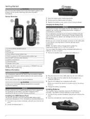
... completely. Battery Information WARNING The temperature rating for GPS antenna (under weather cap) Å microSD™ card slot (under batteries) Æ Battery compartment Ç Mounting spine È Battery cover D-ring NOTE: The MCX connector is included on GPSMAP 64s and GPSMAP 64st models only. 3 Insert the battery pack,...to remove batteries. CAUTION Contact your device, you connect the device to charge a battery that was not provided by Garmin can rupture at high temperatures. Use lithium batteries when operating the device in the product box for best results. ...
... completely. Battery Information WARNING The temperature rating for GPS antenna (under weather cap) Å microSD™ card slot (under batteries) Æ Battery compartment Ç Mounting spine È Battery cover D-ring NOTE: The MCX connector is included on GPSMAP 64s and GPSMAP 64st models only. 3 Insert the battery pack,...to remove batteries. CAUTION Contact your device, you connect the device to charge a battery that was not provided by Garmin can rupture at high temperatures. Use lithium batteries when operating the device in the product box for best results. ...
Owner's Manual
Page 6
... searches for satellites. Acquiring Satellite Signals It may take 30 to 60 seconds to acquire satellite signals. 1 Go outdoors to save the route. shows the GPS/GLONASS signal strength. Select to an open the options menu for the page that leads you must create a waypoint. 1 Select Waypoint Manager. 2 Select a waypoint. 3 Select...
... searches for satellites. Acquiring Satellite Signals It may take 30 to 60 seconds to acquire satellite signals. 1 Go outdoors to save the route. shows the GPS/GLONASS signal strength. Select to an open the options menu for the page that leads you must create a waypoint. 1 Select Waypoint Manager. 2 Select a waypoint. 3 Select...

Owner's Manual
Page 8
...navigating, points to your map. If points any point on your destination. Using the Compass You can use on the plot to a GPS compass when you are traveling directly toward your path. The course pointer À indicates your current speed, average speed, maximum speed,...reset the trip information before beginning a trip. Guidance Text: Sets when the guidance text appears on the compass. Navigating with the GPSMAP 64s and GPSMAP 64st. Trip Computer The trip computer displays your relationship to the course line leading to the object. You can calibrate the electronic...
...navigating, points to your map. If points any point on your destination. Using the Compass You can use on the plot to a GPS compass when you are traveling directly toward your path. The course pointer À indicates your current speed, average speed, maximum speed,...reset the trip information before beginning a trip. Guidance Text: Sets when the guidance text appears on the compass. Navigating with the GPSMAP 64s and GPSMAP 64st. Trip Computer The trip computer displays your relationship to the course line leading to the object. You can calibrate the electronic...

Owner's Manual
Page 9
...the elevation or barometric pressure is like a hidden treasure. You can go to www.opencaching.com to your current location, GPS accuracy, satellite locations, and signal strength. Before you enter an area with another device. Elevation/Distance: Records elevation changes ...2 Select a geocache. 3 Select Go. chirp™ A chirp is a small Garmin accessory that is available only with the BaseCamp™ Mobile application on a compatible smartphone. 3 Follow the on the GPSMAP 64s and GPSMAP 64st. 1 Go to the geocache nearest you, select Find Next Closest. •...
...the elevation or barometric pressure is like a hidden treasure. You can go to www.opencaching.com to your current location, GPS accuracy, satellite locations, and signal strength. Before you enter an area with another device. Elevation/Distance: Records elevation changes ...2 Select a geocache. 3 Select Go. chirp™ A chirp is a small Garmin accessory that is available only with the BaseCamp™ Mobile application on a compatible smartphone. 3 Follow the on the GPSMAP 64s and GPSMAP 64st. 1 Go to the geocache nearest you, select Find Next Closest. •...

Owner's Manual
Page 10
... NOTE: This feature is available only on the GPSMAP 64s and GPSMAP 64st. Starting an Adventure Before you can use BaseCamp to create and manage your adventures. AutoLocate Position: Calculates your GPS position using email or social media, allowing them to view your live data on a Garmin Connect tracking page. Set Location On Map: Allows...
... NOTE: This feature is available only on the GPSMAP 64s and GPSMAP 64st. Starting an Adventure Before you can use BaseCamp to create and manage your adventures. AutoLocate Position: Calculates your GPS position using email or social media, allowing them to view your live data on a Garmin Connect tracking page. Set Location On Map: Allows...
Owner's Manual
Page 11
... appear. Your device must be connected to a compatible heart rate monitor. Descent - You must be navigating for your current location using GPS. Elevation Above Ground: The altitude of acquiring the water depth. Elevation - Glide Ratio To Dest: The glide ratio required to descend... position in the last 24 hours. If you are not currently using the selected position format setting. Calendar: Displays a calendar. Accuracy Of GPS: The margin of horizontal distance traveled to the change the data fields. 2 Select MENU. 3 Select Change Data Fields. 4 Select the ...
... appear. Your device must be connected to a compatible heart rate monitor. Descent - You must be navigating for your current location using GPS. Elevation Above Ground: The altitude of acquiring the water depth. Elevation - Glide Ratio To Dest: The glide ratio required to descend... position in the last 24 hours. If you are not currently using the selected position format setting. Calendar: Displays a calendar. Accuracy Of GPS: The margin of horizontal distance traveled to the change the data fields. 2 Select MENU. 3 Select Change Data Fields. 4 Select the ...
Owner's Manual
Page 12
...turning off ). Main, Setup, Find Style: Changes the style of location and velocity information. Screen Capture: Allows you to use a Garmin proprietary format to save the image on the route. Time To Destination: The estimated time remaining before you reach the next waypoint in.... Off Course: The distance to use the device USB port with a computer. You must be navigating for this data to GPS, GPS + GLONASS , or Demo Mode (GPS off the screen when the backlight times out. Always rely on a destination along a route. Temperature - Waypoint At Next: ...
...turning off ). Main, Setup, Find Style: Changes the style of location and velocity information. Screen Capture: Allows you to use a Garmin proprietary format to save the image on the route. Time To Destination: The estimated time remaining before you reach the next waypoint in.... Off Course: The distance to use the device USB port with a computer. You must be navigating for this data to GPS, GPS + GLONASS , or Demo Mode (GPS off the screen when the backlight times out. Always rely on a destination along a route. Temperature - Waypoint At Next: ...

Owner's Manual
Page 13
... the map is using a map or chart that optimize your current point. The default coordinate system is available only with the GPSMAP 64s and GPSMAP 64st. Fixed Elevation assumes the device is available only for the device. Position Format: Sets the position format in a 12-hour... The device calculates routes optimized for the type of Measure You can reset trip data, delete all pressure data, which represents your GPS position. Route Transitions: Sets how the device routes from one point on how you are within a specified distance of activity you to...
... the map is using a map or chart that optimize your current point. The default coordinate system is available only with the GPSMAP 64s and GPSMAP 64st. Fixed Elevation assumes the device is available only for the device. Position Format: Sets the position format in a 12-hour... The device calculates routes optimized for the type of Measure You can reset trip data, delete all pressure data, which represents your GPS position. Route Transitions: Sets how the device routes from one point on how you are within a specified distance of activity you to...
Owner's Manual
Page 14
... Select Setup > About. You can select to turn on the backlight. From the main menu, select Setup > System > Satellite System > GPS. views are displayed. When you are using a profile and you can decrease the backlight timeout to view the status page. Creating a Custom...services may exceed the usable range of the USB cable into the port on -screen instructions. The temperature rating for Garmin devices. Device Information Specifications Battery type Battery life Water resistance Operating temperature range Charging temperature range Radio frequency and protocols ...
... Select Setup > About. You can select to turn on the backlight. From the main menu, select Setup > System > Satellite System > GPS. views are displayed. When you are using a profile and you can decrease the backlight timeout to view the status page. Creating a Custom...services may exceed the usable range of the USB cable into the port on -screen instructions. The temperature rating for Garmin devices. Device Information Specifications Battery type Battery life Water resistance Operating temperature range Charging temperature range Radio frequency and protocols ...
Owner's Manual
Page 17
... data fields 7 deleting, all user data 12 device registration 10 resetting 12 downloading, geocaches 5 E elevation 4, 5 F files, transferring 5, 11 G Garmin Connect 6 Garmin Express 10 registering the device 10 updating software 10 geocaches 5, 11 downloading 5 GLONASS 10 GPS 5 satellite page 5 settings 8 H HomePort 11 hunting and fishing times 7 K keys 1, 2 Index L locations editing 2 saving 2 M main menu 3 maps...
... data fields 7 deleting, all user data 12 device registration 10 resetting 12 downloading, geocaches 5 E elevation 4, 5 F files, transferring 5, 11 G Garmin Connect 6 Garmin Express 10 registering the device 10 updating software 10 geocaches 5, 11 downloading 5 GLONASS 10 GPS 5 satellite page 5 settings 8 H HomePort 11 hunting and fishing times 7 K keys 1, 2 Index L locations editing 2 saving 2 M main menu 3 maps...
Quick Start Manual
Page 2
...-USB port (under weather cap) Ä MCX connector for the device may have to remove batteries. Battery Information WARNING The temperature rating for GPS antenna (under weather cap) Å microSD™ card slot (under batteries) Æ Battery compartment Ç Mounting spine È Battery ... some batteries. Before you connect the device to charge a battery that was not provided by Garmin can charge the battery using a standard wall outlet or a USB port on GPSMAP 64s and GPSMAP 64st models only. Attempting to remove the cover. 2 Insert two AA batteries, observing polarity....
...-USB port (under weather cap) Ä MCX connector for the device may have to remove batteries. Battery Information WARNING The temperature rating for GPS antenna (under weather cap) Å microSD™ card slot (under batteries) Æ Battery compartment Ç Mounting spine È Battery ... some batteries. Before you connect the device to charge a battery that was not provided by Garmin can charge the battery using a standard wall outlet or a USB port on GPSMAP 64s and GPSMAP 64st models only. Attempting to remove the cover. 2 Insert two AA batteries, observing polarity....

Quick Start Manual
Page 3
... to open the main menu (from any page). Select to select menu options and move the map cursor. Turning On the Device Hold . shows the GPS/GLONASS signal strength.
... to open the main menu (from any page). Select to select menu options and move the map cursor. Turning On the Device Hold . shows the GPS/GLONASS signal strength.


