Quick Start Guide
Page 1
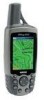
... key to the Find Menu. 1. This page contains a "Bearing Pointer" and a "Compass Ring." A Printed in Taiwan ® GPSMAP 60 map navigator quick start guide GPS Antenna Power Key LCD Display In/Out (Zoom) Keys Page Key Rocker Key Find Key Mark Key Quit Key Enter Key Menu Key... 2. Press the FIND key to display the Mark Waypoint Page. A Bearing line displays on the map, and the Position Arrow moves as destinations. 1. Compass Page Map Page Trip Computer © Copyright 2004 Garmin Ltd. Begin to move the Panning Arrow to display the list of Interest (restaurant, museum, etc...
... key to the Find Menu. 1. This page contains a "Bearing Pointer" and a "Compass Ring." A Printed in Taiwan ® GPSMAP 60 map navigator quick start guide GPS Antenna Power Key LCD Display In/Out (Zoom) Keys Page Key Rocker Key Find Key Mark Key Quit Key Enter Key Menu Key... 2. Press the FIND key to display the Mark Waypoint Page. A Bearing line displays on the map, and the Position Arrow moves as destinations. 1. Compass Page Map Page Trip Computer © Copyright 2004 Garmin Ltd. Begin to move the Panning Arrow to display the list of Interest (restaurant, museum, etc...
Quick Start Guide
Page 2
... make it must initialize (determine its own or press the ENTER key. Press the MENU key to view the GPSmap 60 display. Status Bar 3D GPS indicator Received Satellite icon Position Bug indicates your direction of movement Satellite Signal Strength Bars Satellite Page Options • Turn...an approximate elevation as well as a waypoint. Viewing the Main Pages Information you may be used (see page 43 of the unit. Displays a map and your direction of each overhead satellite. IN IN/OUT Zoom Keys - Press and release to adjust backlighting. Locking 1. USE BY: 2009 3....
... make it must initialize (determine its own or press the ENTER key. Press the MENU key to view the GPSmap 60 display. Status Bar 3D GPS indicator Received Satellite icon Position Bug indicates your direction of movement Satellite Signal Strength Bars Satellite Page Options • Turn...an approximate elevation as well as a waypoint. Viewing the Main Pages Information you may be used (see page 43 of the unit. Displays a map and your direction of each overhead satellite. IN IN/OUT Zoom Keys - Press and release to adjust backlighting. Locking 1. USE BY: 2009 3....

Owner's Manual
Page 1
GPSMAP® 60CS with sensors and maps owner's manual
GPSMAP® 60CS with sensors and maps owner's manual
Owner's Manual
Page 3
... Garmin GPSmap 60CS color map handheld navigation system. Friday, 8 am - 5 pm Central Time; contains the Garmin software license agreement, FCC and safety information, the Table of Contents and an overview of the following sections: Introduction - or by subject. NOTE: If you have any difficulty while using the unit control buttons, initializing the receiver, etc. GPS...
... Garmin GPSmap 60CS color map handheld navigation system. Friday, 8 am - 5 pm Central Time; contains the Garmin software license agreement, FCC and safety information, the Table of Contents and an overview of the following sections: Introduction - or by subject. NOTE: If you have any difficulty while using the unit control buttons, initializing the receiver, etc. GPS...
Owner's Manual
Page 7
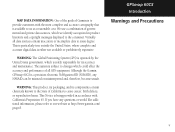
MAP DATA INFORMATION: One of the goals of all data sources contain inaccurate or incomplete data to some degree. WARNING: The Global Positioning System (GPS) is operated by the United States government, which is either not available or prohibitively expensive. GPSmap 60CS Introduction Warnings and ... of governmental and private data sources, which could affect the accuracy and performance of Garmin is to provide customers with California's Proposition 65. Although the Garmin GPSmap 60CS is being provided in product literature and copyright messages displayed to us at http://www...
MAP DATA INFORMATION: One of the goals of all data sources contain inaccurate or incomplete data to some degree. WARNING: The Global Positioning System (GPS) is operated by the United States government, which is either not available or prohibitively expensive. GPSmap 60CS Introduction Warnings and ... of governmental and private data sources, which could affect the accuracy and performance of Garmin is to provide customers with California's Proposition 65. Although the Garmin GPSmap 60CS is being provided in product literature and copyright messages displayed to us at http://www...
Owner's Manual
Page 9
...Started 1-7 Battery Installation and Start Up 1 Key Functions 2 Unit Features 3 Initialization 4 The Satellite Page 4 Navigating with the GPSmap 60CS 5 The Main Page Sequence 6 The Main Page Features 7 Section 3: GPS Navigation 8-68 The Map Page 8 The Compass Page 14 The Altimeter Page 20 The Trip Computer Page 26 Using Waypoints 27 Using Find... 54 The Setup Menu 55 System Setup 55 Display Setup 56 Interface Setup 56 Tones Setup 58 Page Sequence Setup 58 Map Setup 59 Routing Setup 62 Geocache Setup 63 Marine Setup 63 Time Setup 64 Units Setup 64 Heading Setup 65 vii
...Started 1-7 Battery Installation and Start Up 1 Key Functions 2 Unit Features 3 Initialization 4 The Satellite Page 4 Navigating with the GPSmap 60CS 5 The Main Page Sequence 6 The Main Page Features 7 Section 3: GPS Navigation 8-68 The Map Page 8 The Compass Page 14 The Altimeter Page 20 The Trip Computer Page 26 Using Waypoints 27 Using Find... 54 The Setup Menu 55 System Setup 55 Display Setup 56 Interface Setup 56 Tones Setup 58 Page Sequence Setup 58 Map Setup 59 Routing Setup 62 Geocache Setup 63 Marine Setup 63 Time Setup 64 Units Setup 64 Heading Setup 65 vii
Owner's Manual
Page 10
...Chart 89 ..... Wiring Diagram 93..... GPS Enhanced Games 74 Non-Enhanced Game 77 Section 5: Appendix 78-96 Accessories 78 Specifcations 80 Data Field Definitions 82 .... Connecting the GPSmap 60CS to a Computer 87 Downloading MapSource Map Data 88 ..... Proximity Waypoints 68 Index... 94 Limited Warranty 97 Section 4: GPS Features 69-77 Calendar 69 Alarm Clock 70 Calculator 70 Stopwatch 71...
...Chart 89 ..... Wiring Diagram 93..... GPS Enhanced Games 74 Non-Enhanced Game 77 Section 5: Appendix 78-96 Accessories 78 Specifcations 80 Data Field Definitions 82 .... Connecting the GPSmap 60CS to a Computer 87 Downloading MapSource Map Data 88 ..... Proximity Waypoints 68 Index... 94 Limited Warranty 97 Section 4: GPS Features 69-77 Calendar 69 Alarm Clock 70 Calculator 70 Stopwatch 71...
Owner's Manual
Page 12
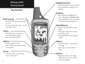
... unit On/Off. • Press and Release to view the Main Menu. QUIT Key • Press and release to cancel data entry or exit a page. 2 GPSmap 60CS IN FIND MARK QUIT OUT PAGE MENU ENTR POWER/BACKLIGHT Key • Press and Hold to turn Compass On/Off. MENU Key • Press and... twice to adjust backlighting. ROCKER Key • Move Up/Down or Right/Left to scroll up or down a list. GPSmap 60CS Getting Started Key Functions IN/OUT Zoom Keys • From the Map Page, press to zoom in or out. • From any other page, press to move through the main pages. •...
... unit On/Off. • Press and Release to view the Main Menu. QUIT Key • Press and release to cancel data entry or exit a page. 2 GPSmap 60CS IN FIND MARK QUIT OUT PAGE MENU ENTR POWER/BACKLIGHT Key • Press and Hold to turn Compass On/Off. MENU Key • Press and... twice to adjust backlighting. ROCKER Key • Move Up/Down or Right/Left to scroll up or down a list. GPSmap 60CS Getting Started Key Functions IN/OUT Zoom Keys • From the Map Page, press to zoom in or out. • From any other page, press to move through the main pages. •...
Owner's Manual
Page 14
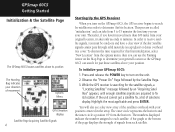
...Satellite Page The GPSmap 60CS locates satellites above your GPSmap 60CS: 1. Thereafter, if you haven't moved more than 600 miles from your unit. In order to minutes. To initialize your position. The numbers displayed indicate the number assigned to turn on the Map Page to determine... centered in order to determine your general location so the GPSmap 60CS can use your original location, it takes only seconds to receive satellite signals, you use the Panning Arrow on the GPSmap 60CS, the GPS receiver begins to search for the satellite signals, a "Locating Satellites...
...Satellite Page The GPSmap 60CS locates satellites above your GPSmap 60CS: 1. Thereafter, if you haven't moved more than 600 miles from your unit. In order to minutes. To initialize your position. The numbers displayed indicate the number assigned to turn on the Map Page to determine... centered in order to determine your general location so the GPSmap 60CS can use your original location, it takes only seconds to receive satellite signals, you use the Panning Arrow on the GPSmap 60CS, the GPS receiver begins to search for the satellite signals, a "Locating Satellites...
Owner's Manual
Page 15
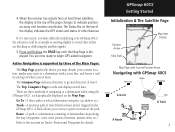
... to retrace a path or return on Tracks, Routes and Waypoints for any reason, you 've been. GPSmap 60CS Getting Started Initialization & The Satellite Page Position Arrow Map Scale Map Item Details Map Page with Current Position Arrow Navigating with a route line, and leaves a trail (track log) of navigating...A direct path to avoid objects that has been stored (logged) in the GPSmap 60CS. When the receiver has signals from at least three satellites, the display at the top of the display indicates the GPS status and status of other features. You are blocking or deflecting ...
... to retrace a path or return on Tracks, Routes and Waypoints for any reason, you 've been. GPSmap 60CS Getting Started Initialization & The Satellite Page Position Arrow Map Scale Map Item Details Map Page with Current Position Arrow Navigating with a route line, and leaves a trail (track log) of navigating...A direct path to avoid objects that has been stored (logged) in the GPSmap 60CS. When the receiver has signals from at least three satellites, the display at the top of the display indicates the GPS status and status of other features. You are blocking or deflecting ...

Owner's Manual
Page 16
With a Page displayed, press the MENU key to cycle through the pages. 2. GPSmap 60CS Getting Started The Main Page Sequence Whenever you turn on the GPSmap 60CS, the Power On Page is followed by the Satellite Page, which is also displayed. To view each Main Page: 1. Press and release the... PAGE key, repeatedly, to display the list of the Main Pages in sequence. Power On Page Satellite Page Trip Computer Page Map Page ...
With a Page displayed, press the MENU key to cycle through the pages. 2. GPSmap 60CS Getting Started The Main Page Sequence Whenever you turn on the GPSmap 60CS, the Power On Page is followed by the Satellite Page, which is also displayed. To view each Main Page: 1. Press and release the... PAGE key, repeatedly, to display the list of the Main Pages in sequence. Power On Page Satellite Page Trip Computer Page Map Page ...

Owner's Manual
Page 18
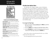
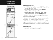
..., parks, etc.) because Garmin MapSource® detailed mapping data has been downloaded from a CD-ROM program. It allows you activate the Track Log feature, your current location. GPSmap 60CS GPS Navigation The Map Page "North Up" Mode with Map oriented with North at the top The Map Scale The Map Page Position Arrow The Map Page (full map) "Track Up" Mode...
..., parks, etc.) because Garmin MapSource® detailed mapping data has been downloaded from a CD-ROM program. It allows you activate the Track Log feature, your current location. GPSmap 60CS GPS Navigation The Map Page "North Up" Mode with Map oriented with North at the top The Map Scale The Map Page Position Arrow The Map Page (full map) "Track Up" Mode...

Owner's Manual
Page 19
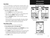
... scale. a list of measurement that can be moved about the page to highlight and identify map items or to scroll the map to view areas not shown on the list. GPSmap 60CS GPS Navigation The Map Page Zoom In Zoom Out Map Features Map Scales Accuracy Circle Panning Arrow Guidance Text 9 Press and hold to provide a variety of...
... scale. a list of measurement that can be moved about the page to highlight and identify map items or to scroll the map to view areas not shown on the list. GPSmap 60CS GPS Navigation The Map Page Zoom In Zoom Out Map Features Map Scales Accuracy Circle Panning Arrow Guidance Text 9 Press and hold to provide a variety of...
Owner's Manual
Page 20
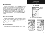
... option in detail. Allows two to four fields to display. Guidance Text - Returns the map display to the factory set map display defaults. 10 The Map Page Options Menu The Map Page can stop navigation to further control of how the option is zoomed out. Some of these ...Recalculates a route and is disabled when there is no active navigation Data Fields - You can be changed to display the Map Page Options Menu. 3. GPSmap 60CS GPS Navigation The Map Page The Map Page Options Menu A Quick Look at the top of the page showing Speed, Heading, Elevation and Time. Stops navigation and...
... option in detail. Allows two to four fields to display. Guidance Text - Returns the map display to the factory set map display defaults. 10 The Map Page Options Menu The Map Page can stop navigation to further control of how the option is zoomed out. Some of these ...Recalculates a route and is disabled when there is no active navigation Data Fields - You can be changed to display the Map Page Options Menu. 3. GPSmap 60CS GPS Navigation The Map Page The Map Page Options Menu A Quick Look at the top of the page showing Speed, Heading, Elevation and Time. Stops navigation and...
Owner's Manual
Page 21
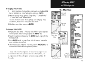
... display of data received from a list of types of Data Field Options 11 To display Data Fields: 1. With Map Page Options Menu displayed, use the ROCKER key to move to leave the Map Page as is (full page map), or add two, three or four navigation data fields. 3. GPSmap 60CS GPS Navigation The Map Page Data Field...
... display of data received from a list of types of Data Field Options 11 To display Data Fields: 1. With Map Page Options Menu displayed, use the ROCKER key to move to leave the Map Page as is (full page map), or add two, three or four navigation data fields. 3. GPSmap 60CS GPS Navigation The Map Page Data Field...
Owner's Manual
Page 22
... If you select "Always Show" a guidance message is displayed until you are not navigating, the message field displays GPS Status information, To Setup the Map: 1. If you select "Always Show" and you useful information when using one of the navigation methods described on page..." or "Show When Navigating" and press ENTER to display the Map Page Options Menu. 2. Highlight the Guidance Text Option and press ENTER to the Map Setup section on page 5. GPSmap 60CS GPS Navigation The Map Page Guidance Text Options Menu GPS Status Message when not navigating To display Guidance Text: 1.
... If you select "Always Show" a guidance message is displayed until you are not navigating, the message field displays GPS Status information, To Setup the Map: 1. If you select "Always Show" and you useful information when using one of the navigation methods described on page..." or "Show When Navigating" and press ENTER to display the Map Page Options Menu. 2. Highlight the Guidance Text Option and press ENTER to the Map Setup section on page 5. GPSmap 60CS GPS Navigation The Map Page Guidance Text Options Menu GPS Status Message when not navigating To display Guidance Text: 1.
Owner's Manual
Page 23
... want to measure from your current location. Turning Declutter On/Off This Map Page option allows you to return the map settings to activate. GPSmap 60CS GPS Navigation The Map Page "Measured Distance" The "Measure Distance" Option Enabled Map Declutter "Off" Map Declutter "On" 13 Access the Map Page Options Menu, select "Measure Distance" and press ENTER to cancel...
... want to measure from your current location. Turning Declutter On/Off This Map Page option allows you to return the map settings to activate. GPSmap 60CS GPS Navigation The Map Page "Measured Distance" The "Measure Distance" Option Enabled Map Declutter "Off" Map Declutter "On" 13 Access the Map Page Options Menu, select "Measure Distance" and press ENTER to cancel...
Owner's Manual
Page 24
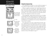
...map or chart in relation to North. When you are stationary. The rotating graphic compass indicates the direction you stop (after a pre-set speed, it again operates like a magnetic compass when you move off course. It uses traditional navigation displays to provide navigation information. You can choose from the GPS receiver... to maintain your heading. Bearing Pointer The Bearing Pointer always indicates the direction to your destination. It uses a graphic compass display and a bearing or course pointer along with your GPSmap 60CS for guidance...
...map or chart in relation to North. When you are stationary. The rotating graphic compass indicates the direction you stop (after a pre-set speed, it again operates like a magnetic compass when you move off course. It uses traditional navigation displays to provide navigation information. You can choose from the GPS receiver... to maintain your heading. Bearing Pointer The Bearing Pointer always indicates the direction to your destination. It uses a graphic compass display and a bearing or course pointer along with your GPSmap 60CS for guidance...
Owner's Manual
Page 27
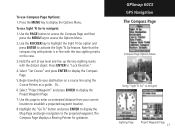
...case. 3. Select "Set Course" and press ENTER to establish a projected waypoint location. 8. Press ENTER to navigate Sighting Page Project Waypoint Page 17 GPSmap 60CS GPS Navigation The Compass Page Compass Page Options Menu Using "Sight 'N Go" to "Lock Direction." 4. Hold the unit at eye level and line ... the compass ring with pointer is in-line with the distant object. Highlight the "Go To" button and press ENTER to display the Map Page and begin navigation to your current location to display the Compass Page. 5. Press the MENU key to display the Project Waypoint Page....
...case. 3. Select "Set Course" and press ENTER to establish a projected waypoint location. 8. Press ENTER to navigate Sighting Page Project Waypoint Page 17 GPSmap 60CS GPS Navigation The Compass Page Compass Page Options Menu Using "Sight 'N Go" to "Lock Direction." 4. Hold the unit at eye level and line ... the compass ring with pointer is in-line with the distant object. Highlight the "Go To" button and press ENTER to display the Map Page and begin navigation to your current location to display the Compass Page. 5. Press the MENU key to display the Project Waypoint Page....
Owner's Manual
Page 33
Press QUIT to display the Plot Page. 3. GPSmap 60CS GPS Navigation The Altimeter Page Red Crosshairs View Point for an Altitude Plot View Point for a Pressure Plot Elevation over Distance Plot Point shown on the Map Page. select either the "View Pressure Plot" or "View Elevation Plot" option and press ENTER to ... changes to display the date, time, and altitude or pressure for the point at a location along the profile. View Points on Map You can scroll through a recorded elevation or pressure profile to view data for any point along the profile, the display...
Press QUIT to display the Plot Page. 3. GPSmap 60CS GPS Navigation The Altimeter Page Red Crosshairs View Point for an Altitude Plot View Point for a Pressure Plot Elevation over Distance Plot Point shown on the Map Page. select either the "View Pressure Plot" or "View Elevation Plot" option and press ENTER to ... changes to display the date, time, and altitude or pressure for the point at a location along the profile. View Points on Map You can scroll through a recorded elevation or pressure profile to view data for any point along the profile, the display...


