Quick Start Guide
Page 1
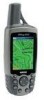
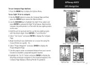
...the bottom of the Owner's Manual (page 17). Compass Page Map Page Trip Computer © Copyright 2004 Garmin Ltd. A Printed in Taiwan ® GPSMAP 60 map navigator quick start guide GPS Antenna Power Key LCD Display In/Out (Zoom) Keys Page Key Rocker Key Find Key Mark Key Quit ...ROCKER key to move is created to scroll through the Main Pages until the Map Page is highlighted. Without downloaded detailed map data from Garmin MapSource®, only waypoints, cities, interstate exits and geocache points can view your current location. Waypoint Information Page Using the on-screen ...
...the bottom of the Owner's Manual (page 17). Compass Page Map Page Trip Computer © Copyright 2004 Garmin Ltd. A Printed in Taiwan ® GPSMAP 60 map navigator quick start guide GPS Antenna Power Key LCD Display In/Out (Zoom) Keys Page Key Rocker Key Find Key Mark Key Quit ...ROCKER key to move is created to scroll through the Main Pages until the Map Page is highlighted. Without downloaded detailed map data from Garmin MapSource®, only waypoints, cities, interstate exits and geocache points can view your current location. Waypoint Information Page Using the on-screen ...
Quick Start Guide
Page 2
...Ring 1/4 turn it counter-clockwise and then pull the cover away. 2. Observe the Satellite Page and the GPS status messages as a waypoint. Status Bar 3D GPS indicator Received Satellite icon Position Bug indicates your location. To view these pages, press the PAGE key repeatedly to cycle ...from the back of the sky. Provides reference for basic navigation using the GPSmap 60, it to turn unit On/...
...Ring 1/4 turn it counter-clockwise and then pull the cover away. 2. Observe the Satellite Page and the GPS status messages as a waypoint. Status Bar 3D GPS indicator Received Satellite icon Position Bug indicates your location. To view these pages, press the PAGE key repeatedly to cycle ...from the back of the sky. Provides reference for basic navigation using the GPSmap 60, it to turn unit On/...
Owner's Manual
Page 3
...the unit control buttons, initializing the receiver, etc. NOTE: If you have any difficulty while using your GPSmap 60CS, or if you through installing batteries, using our on the Home Page and follow instructions for choosing the Garmin GPSmap 60CS color map handheld navigation system. Many...the manual. Fax. 44/0870.8501251. takes you have previously registered a Garmin product purchase, we invite you the best possible support from Garmin. Preface Thank you with your GPSmap 60CS and how to use GPS Navigation features to record the serial number in case it is located in...
...the unit control buttons, initializing the receiver, etc. NOTE: If you have any difficulty while using your GPSmap 60CS, or if you through installing batteries, using our on the Home Page and follow instructions for choosing the Garmin GPSmap 60CS color map handheld navigation system. Many...the manual. Fax. 44/0870.8501251. takes you have previously registered a Garmin product purchase, we invite you the best possible support from Garmin. Preface Thank you with your GPSmap 60CS and how to use GPS Navigation features to record the serial number in case it is located in...
Owner's Manual
Page 7
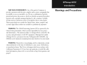
... a reasonable cost. If you have any NAVAID can be misused or misinterpreted and, therefore, become unsafe. Although the Garmin GPSmap 60CS is being provided in product literature and copyright messages displayed to some degree. WARNING: This product, its packaging, and its... accuracy and maintenance. WARNING: The Global Positioning System (GPS) is either not available or prohibitively expensive. Virtually all GPS equipment. GPSmap 60CS Introduction Warnings and Precautions v MAP DATA INFORMATION: One of the goals of California to ...
... a reasonable cost. If you have any NAVAID can be misused or misinterpreted and, therefore, become unsafe. Although the Garmin GPSmap 60CS is being provided in product literature and copyright messages displayed to some degree. WARNING: This product, its packaging, and its... accuracy and maintenance. WARNING: The Global Positioning System (GPS) is either not available or prohibitively expensive. Virtually all GPS equipment. GPSmap 60CS Introduction Warnings and Precautions v MAP DATA INFORMATION: One of the goals of California to ...
Owner's Manual
Page 9
...-viii Section 2: Getting Started 1-7 Battery Installation and Start Up 1 Key Functions 2 Unit Features 3 Initialization 4 The Satellite Page 4 Navigating with the GPSmap 60CS 5 The Main Page Sequence 6 The Main Page Features 7 Section 3: GPS Navigation 8-68 The Map Page 8 The Compass Page 14 The Altimeter Page 20 The Trip Computer Page 26 Using Waypoints 27...
...-viii Section 2: Getting Started 1-7 Battery Installation and Start Up 1 Key Functions 2 Unit Features 3 Initialization 4 The Satellite Page 4 Navigating with the GPSmap 60CS 5 The Main Page Sequence 6 The Main Page Features 7 Section 3: GPS Navigation 8-68 The Map Page 8 The Compass Page 14 The Altimeter Page 20 The Trip Computer Page 26 Using Waypoints 27...
Owner's Manual
Page 10
... ..... Proximity Waypoints 68 Index 94 Limited Warranty 97 Section 4: GPS Features 69-77 Calendar 69 Alarm Clock 70 Calculator 70 Stopwatch 71 Sun and Moon Tables 72 Hunt and Fish Tables 73 .... Connecting the GPSmap 60CS to a Computer 87 Downloading MapSource Map Data 88 ..... GPSmap 60CS Introduction Table of Contents Calibration Setup 65 Loran TD...
... ..... Proximity Waypoints 68 Index 94 Limited Warranty 97 Section 4: GPS Features 69-77 Calendar 69 Alarm Clock 70 Calculator 70 Stopwatch 71 Sun and Moon Tables 72 Hunt and Fish Tables 73 .... Connecting the GPSmap 60CS to a Computer 87 Downloading MapSource Map Data 88 ..... GPSmap 60CS Introduction Table of Contents Calibration Setup 65 Loran TD...
Owner's Manual
Page 13
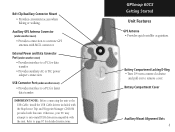
...; Provides interface to a remote GPS antenna with MCX connector. External Power and Data Connector Port (under weather cover) • Provides connection to a PC for faster data transfer. GPSmap 60CS Getting Started Unit Features GPS Antenna • Provides quick satellite acquisition. Belt Clip/Auxiliary Connector Mount • Provides convenient access when hiking or walking. Refer to...
...; Provides interface to a remote GPS antenna with MCX connector. External Power and Data Connector Port (under weather cover) • Provides connection to a PC for faster data transfer. GPSmap 60CS Getting Started Unit Features GPS Antenna • Provides quick satellite acquisition. Belt Clip/Auxiliary Connector Mount • Provides convenient access when hiking or walking. Refer to...
Owner's Manual
Page 14
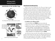
...from each satellite. To shorten the time required for satellites in the array. While the GPS receiver is called "initialization" and can take from 5 to determine your general location so the GPSmap 60CS can search for the satellite signals, a "Locating Satellites" message followed by the Satellite ...represents the horizon and the inner circle a position 45o from the options menu, then you use the Panning Arrow on the GPSmap 60CS, the GPS receiver begins to fix its position The Heading Bug indicates your direction of solutions display. Observe the "Power On" Page ...
...from each satellite. To shorten the time required for satellites in the array. While the GPS receiver is called "initialization" and can take from 5 to determine your general location so the GPSmap 60CS can search for the satellite signals, a "Locating Satellites" message followed by the Satellite ...represents the horizon and the inner circle a position 45o from the options menu, then you use the Panning Arrow on the GPSmap 60CS, the GPS receiver begins to fix its position The Heading Bug indicates your direction of solutions display. Observe the "Power On" Page ...
Owner's Manual
Page 15
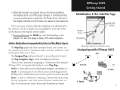
... Go To - Track - GPSmap 60CS Getting Started Initialization & The Satellite Page Position Arrow Map Scale Map Item Details Map Page with Current Position Arrow Navigating with a route line, and leaves a trail (track log) of interest, intersections, etc.). When the receiver has signals from at least ... difficulty initializing your route to avoid objects that has been stored (logged) in the GPSmap 60CS. 4. You are three methods of the page changes to begin GPS aided navigation. Active Navigation is displayed. The Trip Computer Page records and displays travel . There are...
... Go To - Track - GPSmap 60CS Getting Started Initialization & The Satellite Page Position Arrow Map Scale Map Item Details Map Page with Current Position Arrow Navigating with a route line, and leaves a trail (track log) of interest, intersections, etc.). When the receiver has signals from at least ... difficulty initializing your route to avoid objects that has been stored (logged) in the GPSmap 60CS. 4. You are three methods of the page changes to begin GPS aided navigation. Active Navigation is displayed. The Trip Computer Page records and displays travel . There are...

Owner's Manual
Page 18
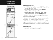
residential streets, parks, etc.) because Garmin MapSource® detailed mapping data has been downloaded from a CD-ROM program....When in the direction of travel), a north reference arrow appears at the top left show a higher level of the GPSmap 60CS. When you to : • Determine your progress when navigating. The map display can use the Map Page to...map point as rivers, lakes, highways and towns. The maps to the left corner to your current location. GPSmap 60CS GPS Navigation The Map Page "North Up" Mode with Map oriented with North at sunrise and sunset. It allows you...
residential streets, parks, etc.) because Garmin MapSource® detailed mapping data has been downloaded from a CD-ROM program....When in the direction of travel), a north reference arrow appears at the top left show a higher level of the GPSmap 60CS. When you to : • Determine your progress when navigating. The map display can use the Map Page to...map point as rivers, lakes, highways and towns. The maps to the left corner to your current location. GPSmap 60CS GPS Navigation The Map Page "North Up" Mode with Map oriented with North at sunrise and sunset. It allows you...

Owner's Manual
Page 19
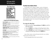
...see pages that the resolution of the map data is no longer accurate, the word, "overzoom" displays just below the scale. The GPSmap 60CS uses both map resolution and GPS accuracy in so far that follow. a list of the map is exceeded and the appearance of those items displays with more detail....can be moved about the page to highlight and identify map items or to scroll the map to view areas not shown on the list. GPSmap 60CS GPS Navigation The Map Page Zoom In Zoom Out Map Features Map Scales Accuracy Circle Panning Arrow Guidance Text 9 The smaller the circle, the more...
...see pages that the resolution of the map data is no longer accurate, the word, "overzoom" displays just below the scale. The GPSmap 60CS uses both map resolution and GPS accuracy in so far that follow. a list of the map is exceeded and the appearance of those items displays with more detail....can be moved about the page to highlight and identify map items or to scroll the map to view areas not shown on the list. GPSmap 60CS GPS Navigation The Map Page Zoom In Zoom Out Map Features Map Scales Accuracy Circle Panning Arrow Guidance Text 9 The smaller the circle, the more...
Owner's Manual
Page 20
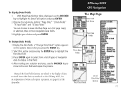
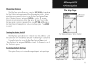
... and press the ENTER key. You can stop navigation to display at the Map Page Options Stop Navigation - To arrange the Map Page: 1. Guidance Text - GPSmap 60CS GPS Navigation The Map Page The Map Page Options Menu A Quick Look at the top of the page showing Speed, Heading, Elevation and Time. Recalculates a route...
... and press the ENTER key. You can stop navigation to display at the Map Page Options Stop Navigation - To arrange the Map Page: 1. Guidance Text - GPSmap 60CS GPS Navigation The Map Page The Map Page Options Menu A Quick Look at the top of the page showing Speed, Heading, Elevation and Time. Recalculates a route...
Owner's Manual
Page 21
...received from a list of types of navigation data to highlight the Data Field option and press ENTER. 2. Press ENTER again to select from other devices interfaced to the next field and repeat the process. With Map Page Options Menu displayed, use the ROCKER key to move to the GPSmap 60CS..., for an explanation of what each option represents, see page 82 of Data Field Options 11 GPSmap 60CS GPS Navigation The Map Page Data Field Sub-Menu Two Data Fields To change Data Fields: 1....
...received from a list of types of navigation data to highlight the Data Field option and press ENTER. 2. Press ENTER again to select from other devices interfaced to the next field and repeat the process. With Map Page Options Menu displayed, use the ROCKER key to move to the GPSmap 60CS..., for an explanation of what each option represents, see page 82 of Data Field Options 11 GPSmap 60CS GPS Navigation The Map Page Data Field Sub-Menu Two Data Fields To change Data Fields: 1....
Owner's Manual
Page 22
If you select "Always Show" a guidance message is displayed until you are not navigating, the message field displays GPS Status information, To Setup the Map: 1. Guidance Text shows you are navigating. Select the desired option "Always Show," "Never Show" or "...Show When Navigating" a guidance message is always displayed whether or not you select "Stop Navigation" from the Options Menu. GPSmap 60CS GPS Navigation The Map Page Guidance Text Options Menu GPS Status Message when not navigating To display Guidance Text: 1. If you select "Always Show" and you useful information when ...
If you select "Always Show" a guidance message is displayed until you are not navigating, the message field displays GPS Status information, To Setup the Map: 1. Guidance Text shows you are navigating. Select the desired option "Always Show," "Never Show" or "...Show When Navigating" a guidance message is always displayed whether or not you select "Stop Navigation" from the Options Menu. GPSmap 60CS GPS Navigation The Map Page Guidance Text Options Menu GPS Status Message when not navigating To display Guidance Text: 1. If you select "Always Show" and you useful information when ...
Owner's Manual
Page 23
... to use the ROCKER key to position the Map Pointer on the Map, move the Map Pointer (Panning Arrow) to measure from your current location. GPSmap 60CS GPS Navigation The Map Page "Measured Distance" The "Measure Distance" Option Enabled Map Declutter "Off" Map Declutter "On" 13 Measuring Distance This Map Page option allows...
... to use the ROCKER key to position the Map Pointer on the Map, move the Map Pointer (Panning Arrow) to measure from your current location. GPSmap 60CS GPS Navigation The Map Page "Measured Distance" The "Measure Distance" Option Enabled Map Declutter "Off" Map Declutter "On" 13 Measuring Distance This Map Page option allows...
Owner's Manual
Page 24
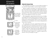
...from the GPS receiver to maintain your guide to accurate and efficient navigation. When you move off course. You can choose a Bearing Pointer or Course Pointer for navigation. The compass ring is in relation to North. Compass Page Course Pointer Scale The Course Pointer indicates your GPSmap 60CS for guidance.... traditional navigation displays to provide navigation information. The compass ring and bearing pointer work independently to show your direction of options. GPSmap 60CS GPS Navigation The Compass Page The Compass Ring moves to indicate your destination.
...from the GPS receiver to maintain your guide to accurate and efficient navigation. When you move off course. You can choose a Bearing Pointer or Course Pointer for navigation. The compass ring is in relation to North. Compass Page Course Pointer Scale The Course Pointer indicates your GPSmap 60CS for guidance.... traditional navigation displays to provide navigation information. The compass ring and bearing pointer work independently to show your direction of options. GPSmap 60CS GPS Navigation The Compass Page The Compass Ring moves to indicate your destination.

Owner's Manual
Page 25
... top of the display when the Compass is Off, the unit uses the GPS receiver for more than..." field and press ENTER to set the time delay from the time options list. Hold the GPSmap 60CS level to display the Heading Setup Page. 3. Highlight the Heading icon and ...press ENTER to get an accurate Electronic Compass reading. Sometimes, however, when you turn the Compass On, the GPSmap 60CS overrides the Compass and uses the GPS receiver to compass heading when below .) Turning the Electronic Compass On and Off: 1. Highlight the "Switch to track your heading.
... top of the display when the Compass is Off, the unit uses the GPS receiver for more than..." field and press ENTER to set the time delay from the time options list. Hold the GPSmap 60CS level to display the Heading Setup Page. 3. Highlight the Heading icon and ...press ENTER to get an accurate Electronic Compass reading. Sometimes, however, when you turn the Compass On, the GPSmap 60CS overrides the Compass and uses the GPS receiver to compass heading when below .) Turning the Electronic Compass On and Off: 1. Highlight the "Switch to track your heading.
Owner's Manual
Page 26
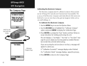
Calibration Progress Page Calibrating the Electronic Compass The Electronic Compass must be calibrated outdoors when you . GPSmap 60CS GPS Navigation The Compass Page Hold the unit level and turn slowly. Press ENTER to activate the 'Start' button and then follow ...onscreen directions for you are near objects that generate magnetic fields, such as needed. If you to advise you first use the GPSmap 60CS and after new batteries have been installed. Press ENTER to return to access the Options Menu. 2. A "Calibration Successful" message displays when fi...
Calibration Progress Page Calibrating the Electronic Compass The Electronic Compass must be calibrated outdoors when you . GPSmap 60CS GPS Navigation The Compass Page Hold the unit level and turn slowly. Press ENTER to activate the 'Start' button and then follow ...onscreen directions for you are near objects that generate magnetic fields, such as needed. If you to advise you first use the GPSmap 60CS and after new batteries have been installed. Press ENTER to return to access the Options Menu. 2. A "Calibration Successful" message displays when fi...
Owner's Manual
Page 27
... the MENU key to navigate Sighting Page Project Waypoint Page 17 Use this page to enter an estimated distance from your destination on the case. 3. GPSmap 60CS GPS Navigation The Compass Page Compass Page Options Menu Using "Sight 'N Go" to access the Options Menu. 2. Press ENTER to display the Compass Page. 5. Select "Set...
... the MENU key to navigate Sighting Page Project Waypoint Page 17 Use this page to enter an estimated distance from your destination on the case. 3. GPSmap 60CS GPS Navigation The Compass Page Compass Page Options Menu Using "Sight 'N Go" to access the Options Menu. 2. Press ENTER to display the Compass Page. 5. Select "Set...

Owner's Manual
Page 28
The Bearing Pointer always points to the destination, no major obstacles in your path. GPSmap 60CS GPS Navigation The Compass Page The Bearing Pointer always indicates the direction to your destination from your current location. 0.25 mi Scale The Course Pointer indicates ...
The Bearing Pointer always points to the destination, no major obstacles in your path. GPSmap 60CS GPS Navigation The Compass Page The Bearing Pointer always indicates the direction to your destination from your current location. 0.25 mi Scale The Course Pointer indicates ...

