Quick Start Guide
Page 2
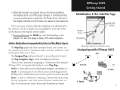
... in position over your direction of movement Satellite Signal Strength Bars Satellite Page Options • Turn GPS Off • Orient display to determine an approximate elevation as well as the GPSmap 60 begins to search for only those satellites above your current location as shown). • Use... key. Turn On the GPSmap 60 by the Main Pages. Observe the Satellite Page and the GPS status messages as they appear at any time to change the contrast level for the backlight and set the contrast percentage. Status Bar 3D GPS indicator Received Satellite icon Position Bug indicates...
... in position over your direction of movement Satellite Signal Strength Bars Satellite Page Options • Turn GPS Off • Orient display to determine an approximate elevation as well as the GPSmap 60 begins to search for only those satellites above your current location as shown). • Use... key. Turn On the GPSmap 60 by the Main Pages. Observe the Satellite Page and the GPS status messages as they appear at any time to change the contrast level for the backlight and set the contrast percentage. Status Bar 3D GPS indicator Received Satellite icon Position Bug indicates...
Owner's Manual
Page 3
... you through installing batteries, using the unit control buttons, initializing the receiver, etc. Many services provided by e-mail at www.garmin.com/contactUs/techSupport.jsp In Europe, contact Garmin (Europe) Ltd. Getting Started - provides you with your GPSmap 60CS and how to use GPS Navigation features to record the serial number in the battery compartment. Recording...
... you through installing batteries, using the unit control buttons, initializing the receiver, etc. Many services provided by e-mail at www.garmin.com/contactUs/techSupport.jsp In Europe, contact Garmin (Europe) Ltd. Getting Started - provides you with your GPSmap 60CS and how to use GPS Navigation features to record the serial number in the battery compartment. Recording...
Owner's Manual
Page 14
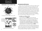
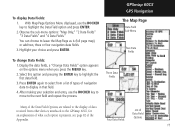
..., select "New Location" from each satellite. The numbers displayed indicate the number assigned to receive satellite signals, you must be outdoors and have a clear view of signals from the options menu, then you turn on the GPSmap 60CS, the GPS receiver begins to search for the satellite signals, a "Locating Satellites" message followed by the Satellite...
..., select "New Location" from each satellite. The numbers displayed indicate the number assigned to receive satellite signals, you must be outdoors and have a clear view of signals from the options menu, then you turn on the GPSmap 60CS, the GPS receiver begins to search for the satellite signals, a "Locating Satellites" message followed by the Satellite...
Owner's Manual
Page 15
... position accuracy and location coordinates. When the receiver has signals from at least three satellites, the display at the top of the display indicates the GPS status and status of navigating to avoid objects that has been stored (logged) in the GPSmap 60CS. The Compass Page indicates direction to go... and direction of the page changes to begin GPS aided navigation. You are blocking or defl...
... position accuracy and location coordinates. When the receiver has signals from at least three satellites, the display at the top of the display indicates the GPS status and status of navigating to avoid objects that has been stored (logged) in the GPSmap 60CS. The Compass Page indicates direction to go... and direction of the page changes to begin GPS aided navigation. You are blocking or defl...
Owner's Manual
Page 21
Press ENTER again to select from a list of types of data received from other devices interfaced to the next field and repeat the process. GPSmap 60CS GPS Navigation The Map Page Data Field Sub-Menu Two Data Fields To change Data Fields: 1. With Map Page Options Menu displayed, use ...the ROCKER key to move to the GPSmap 60CS, for an explanation of what each option represents, see...
Press ENTER again to select from a list of types of data received from other devices interfaced to the next field and repeat the process. GPSmap 60CS GPS Navigation The Map Page Data Field Sub-Menu Two Data Fields To change Data Fields: 1. With Map Page Options Menu displayed, use ...the ROCKER key to move to the GPSmap 60CS, for an explanation of what each option represents, see...
Owner's Manual
Page 24
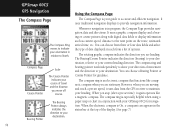
You can choose from three or four data fields and select the type of data displayed in each from the GPS receiver to maintain your GPSmap 60CS for guidance. However, when you are moving and reach a pre-set time), it uses data from a list of the display. (See...Course Pointer indicates the direction (bearing) to your destination, relative to your orientation in the status bar at the top of options. GPSmap 60CS GPS Navigation The Compass Page The Compass Ring moves to indicate your current heading direction. Compass Page Course Pointer Scale The Course Pointer indicates...
You can choose from three or four data fields and select the type of data displayed in each from the GPS receiver to maintain your GPSmap 60CS for guidance. However, when you are moving and reach a pre-set time), it uses data from a list of the display. (See...Course Pointer indicates the direction (bearing) to your destination, relative to your orientation in the status bar at the top of options. GPSmap 60CS GPS Navigation The Compass Page The Compass Ring moves to indicate your current heading direction. Compass Page Course Pointer Scale The Course Pointer indicates...

Owner's Manual
Page 25
...press ENTER to get an accurate Electronic Compass reading. Highlight the Heading icon and press ENTER to turn the Electronic Compass On or Off. GPSmap 60CS GPS Navigation The Compass Page Electronic Compass "On" and "Off" messages Speed Setting Time Delay Options Heading Setup Page with Compass Switch Options ...Auto On/Off: 1. When the Compass is On. A "Hold Level" reminder displays if you turn the Compass On, the GPSmap 60CS overrides the Compass and uses the GPS receiver to track your heading. The criteria for more than..." field and press ENTER to set the time delay from the ...
...press ENTER to get an accurate Electronic Compass reading. Highlight the Heading icon and press ENTER to turn the Electronic Compass On or Off. GPSmap 60CS GPS Navigation The Compass Page Electronic Compass "On" and "Off" messages Speed Setting Time Delay Options Heading Setup Page with Compass Switch Options ...Auto On/Off: 1. When the Compass is On. A "Hold Level" reminder displays if you turn the Compass On, the GPSmap 60CS overrides the Compass and uses the GPS receiver to track your heading. The criteria for more than..." field and press ENTER to set the time delay from the ...

Owner's Manual
Page 66
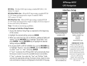
... can significantly save on battery power. The proprietary format used to exchange waypoint, route, track log and MapSource data with a Garmin differential beacon receiver. It provides for a feature field highlighted, press ENTER to select. Text Out - Interface Setup The Interface Setup Page...viewing. Allows ASCII text output of standard NMEA 0183 version 3.01 data. GARMIN DGPS - Use the ROCKER key to select the feature field and setup options menus. 2. GPSmap 60CS GPS Navigation Display Setup Color Scheme Options Backlight Timeout Options Display Setup Page Interface ...
... can significantly save on battery power. The proprietary format used to exchange waypoint, route, track log and MapSource data with a Garmin differential beacon receiver. It provides for a feature field highlighted, press ENTER to select. Text Out - Interface Setup The Interface Setup Page...viewing. Allows ASCII text output of standard NMEA 0183 version 3.01 data. GARMIN DGPS - Use the ROCKER key to select the feature field and setup options menus. 2. GPSmap 60CS GPS Navigation Display Setup Color Scheme Options Backlight Timeout Options Display Setup Page Interface ...
Owner's Manual
Page 67
...and press ENTER. If "Scan" is selected, the GPSmap 60CS will automatically direct the beacon receiver to scan for : NMEA In/NMEA Out Text Out RTCM In RTCM In/Text Out IMPORTANT NOTE: When the USB cable is connected, Garmin format will appear. When the USB is connected to beacon... selected, then select the "Freq" and "Bit Rate" fields and enter the appropriate settings. RTCM In - GPSmap 60CS GPS Navigation Interface Setup Data Format Page for GARMIN DGPS Data Format Page for RTCM In/NMEA Out Data Format Page for available beacon transmitters. Use the ROCKER key to ...
...and press ENTER. If "Scan" is selected, the GPSmap 60CS will automatically direct the beacon receiver to scan for : NMEA In/NMEA Out Text Out RTCM In RTCM In/Text Out IMPORTANT NOTE: When the USB cable is connected, Garmin format will appear. When the USB is connected to beacon... selected, then select the "Freq" and "Bit Rate" fields and enter the appropriate settings. RTCM In - GPSmap 60CS GPS Navigation Interface Setup Data Format Page for GARMIN DGPS Data Format Page for RTCM In/NMEA Out Data Format Page for available beacon transmitters. Use the ROCKER key to ...
Owner's Manual
Page 77
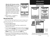
... 3 again. When finished, a "Completed" or "Failed" message displays. Use the ROCKER key to determine the elevation: the GPS receiver estimates the current elevation when determining its location. Use the keypad at the beginning of the screen to insert a message such as explained ...from a known source, but is sufficient for most navigation applications. 2. press and hold the PAGE key. 4. GPSmap 60CS GPS Navigation Altimeter Setup Calibration Complete Press ENTER Calibration Failed Press ENTER and retry Welcome Page Setup Text and Number Keypad Placing your unit...
... 3 again. When finished, a "Completed" or "Failed" message displays. Use the ROCKER key to determine the elevation: the GPS receiver estimates the current elevation when determining its location. Use the keypad at the beginning of the screen to insert a message such as explained ...from a known source, but is sufficient for most navigation applications. 2. press and hold the PAGE key. 4. GPSmap 60CS GPS Navigation Altimeter Setup Calibration Complete Press ENTER Calibration Failed Press ENTER and retry Welcome Page Setup Text and Number Keypad Placing your unit...
Owner's Manual
Page 90
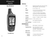
GPSmap 60CS Appendix Specifications S GPSmap 60CS 80 PHYSICAL Case: Rugged, fully gasketed, water resistant, IEC-529, IPX7 (Submersible 1 meter @ 30 minutes) Size: 6.1"H x 2.4"W x 1.3"D Weight: 5.4 ounces (153 ... Altimeter: Accuracy; +/- 10 feet1, resolution; 1 foot Keypad: Operating Range: Nine multifunction backlit keys 5 to 158oF (-15 to 70oC)2 PERFORMANCE Receiver: Acquisition Time: Update Rate: GPS Accuracy Position: Velocity: WAAS enabled, 12 parallel channel Warm: Approximately 15 seconds Cold: Approximately 45 seconds AutoLocate™: Approximately 2 minutes Once per ...
GPSmap 60CS Appendix Specifications S GPSmap 60CS 80 PHYSICAL Case: Rugged, fully gasketed, water resistant, IEC-529, IPX7 (Submersible 1 meter @ 30 minutes) Size: 6.1"H x 2.4"W x 1.3"D Weight: 5.4 ounces (153 ... Altimeter: Accuracy; +/- 10 feet1, resolution; 1 foot Keypad: Operating Range: Nine multifunction backlit keys 5 to 158oF (-15 to 70oC)2 PERFORMANCE Receiver: Acquisition Time: Update Rate: GPS Accuracy Position: Velocity: WAAS enabled, 12 parallel channel Warm: Approximately 15 seconds Cold: Approximately 45 seconds AutoLocate™: Approximately 2 minutes Once per ...
Owner's Manual
Page 91
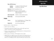
Some batteries can rupture at high temperatures. 3. Use Lithium batteries when operating the GPS map 60CS in North America. (DGPS using Beacon Receiver input.) 5. Extensive use )5 Specifications subject to proper user calibration. 2. Waas (DGPS) Accuracy Position: ...64257;nite: no memory battery required Map Storage: Internal; The temperature rating of the GPSmap 60CS may exceed the usable range of their capacity as the temperature decreases. GPSmap 60CS Appendix Specifications 81 Subject to change without notice. 1. DoD imposed Selective Availability...
Some batteries can rupture at high temperatures. 3. Use Lithium batteries when operating the GPS map 60CS in North America. (DGPS using Beacon Receiver input.) 5. Extensive use )5 Specifications subject to proper user calibration. 2. Waas (DGPS) Accuracy Position: ...64257;nite: no memory battery required Map Storage: Internal; The temperature rating of the GPSmap 60CS may exceed the usable range of their capacity as the temperature decreases. GPSmap 60CS Appendix Specifications 81 Subject to change without notice. 1. DoD imposed Selective Availability...
Owner's Manual
Page 102
... is still in the form of a beacon receiver compatible with an accuracy of 7 meters (21-22 ft.) both horizontally and vertically 95% of GPS by your unit to improve the overall integrity of... Defense under their Selective Availability (SA) program. Using DGPS requires interfacing of your Garmin GPS. The U.S. funded project to additional equipment in the developmental stage with a goal of...the accuracy of the time. GPSmap 60CS Appendix WAAS and DGPS 92 What is available for use without fee. The Wide Area Augmentation System (WAAS) is Differential GPS (DGPS)? Refer to compensating ...
... is still in the form of a beacon receiver compatible with an accuracy of 7 meters (21-22 ft.) both horizontally and vertically 95% of GPS by your unit to improve the overall integrity of... Defense under their Selective Availability (SA) program. Using DGPS requires interfacing of your Garmin GPS. The U.S. funded project to additional equipment in the developmental stage with a goal of...the accuracy of the time. GPSmap 60CS Appendix WAAS and DGPS 92 What is available for use without fee. The Wide Area Augmentation System (WAAS) is Differential GPS (DGPS)? Refer to compensating ...
Owner's Manual
Page 103
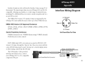
... Sentences: GPGGA, GPGLL, GPGSA, GPGSV, GPRMB, GPRMC, GPRTE, GPVTG, GPWPL, GPBOD Garmin Proprietary Sentences: PGRME (estimated error), PGRMM (datum string), PGRMZ (altitude), PSLIB (beacon receiver control) DGPS (Differential GPS) corrections are accepted in RTCM SC-104 version 2.0 format through the "Data In" line. GPSmap 60CS Appendix Interface Wiring Diagram (-) Ground () () Data In () () Data Out (+) Power...
... Sentences: GPGGA, GPGLL, GPGSA, GPGSV, GPRMB, GPRMC, GPRTE, GPVTG, GPWPL, GPBOD Garmin Proprietary Sentences: PGRME (estimated error), PGRMM (datum string), PGRMZ (altitude), PSLIB (beacon receiver control) DGPS (Differential GPS) corrections are accepted in RTCM SC-104 version 2.0 format through the "Data In" line. GPSmap 60CS Appendix Interface Wiring Diagram (-) Ground () () Data In () () Data Out (+) Power...

