Owner's Manual
Page 19
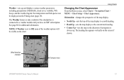
Wind direction indicator Compass rose GPSMAP 400/500 Series Owner's Manual 13 The Weather feature is only available if the chartplotter is connected to the current track heading. • Course Up-... options will be displayed on the Fishing chart (page 19). Note: If Weather is always up and displays various weather parameters, including precipitation (NEXRAD), cloud cover, visibility, WX buoys, and the weather legend. Using Charts Changing the Chart Appearance From the Home screen, select Charts > Navigation Chart > MENU > Chart Setup > Chart...
Wind direction indicator Compass rose GPSMAP 400/500 Series Owner's Manual 13 The Weather feature is only available if the chartplotter is connected to the current track heading. • Course Up-... options will be displayed on the Fishing chart (page 19). Note: If Weather is always up and displays various weather parameters, including precipitation (NEXRAD), cloud cover, visibility, WX buoys, and the weather legend. Using Charts Changing the Chart Appearance From the Home screen, select Charts > Navigation Chart > MENU > Chart Setup > Chart...
Owner's Manual
Page 20
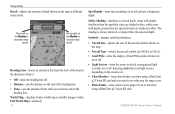
... of travel. • Off-turns the heading line off when using a BlueChart g2 Vision SD card and you want to see what area the maps cover. • Photo Points-turns camera icons (page 21) on or off . • Distance-sets the distance to the end of the heading line. • ... of the heading line. Areas with depths shallower than the specified value are shaded in blue, while areas with depths greater than , the selected depth. GPSMAP 400/500 Series Owner's Manual Symbols-changes symbol preferences. • Navaid Size-adjusts the size of the navaid symbols shown on the map. • ...
... of travel. • Off-turns the heading line off when using a BlueChart g2 Vision SD card and you want to see what area the maps cover. • Photo Points-turns camera icons (page 21) on or off . • Distance-sets the distance to the end of the heading line. • ... of the heading line. Areas with depths shallower than the specified value are shaded in blue, while areas with depths greater than , the selected depth. GPSMAP 400/500 Series Owner's Manual Symbols-changes symbol preferences. • Navaid Size-adjusts the size of the navaid symbols shown on the map. • ...
Owner's Manual
Page 24
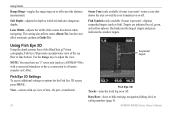
... or lake bottom. This setting also affects routes (Route To), but does not affect automatic guidance (Guide To). Use the Range keys to a Garmin sounder via CANet. View-selects a fish eye view of fore, aft, port, or starboard. 18 Suspended targets Fish Eye 3D Tracks-turns the...or off. Targets are indicated by your transducer on or off to provide distance measurement. GPSMAP 400/500 Series Owner's Manual Fish Symbols (only available if sonar is present)-turns a cone that shows the area covered by red, green, and yellow spheres. Note: You must have a connection to ...
... or lake bottom. This setting also affects routes (Route To), but does not affect automatic guidance (Guide To). Use the Range keys to a Garmin sounder via CANet. View-selects a fish eye view of fore, aft, port, or starboard. 18 Suspended targets Fish Eye 3D Tracks-turns the...or off. Targets are indicated by your transducer on or off to provide distance measurement. GPSMAP 400/500 Series Owner's Manual Fish Symbols (only available if sonar is present)-turns a cone that shows the area covered by red, green, and yellow spheres. Note: You must have a connection to ...
Owner's Manual
Page 25
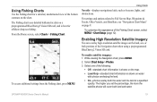
...for offshore deep-sea fishing. Select Chart Setup > Photos. 3. Using Charts Navaids-displays navigational aids, such as beacons, lights, and obstructions. To enable satellite imagery: 1. GPSMAP 400/500 Series Owner's Manual 19 Enabling High Resolution Satellite Imagery You can overlay high-resolution satellite images on the map. • Land Only-standard... information is shown on the land, sea, or both land and water. The higher you set the percentage, the more the satellite photos will cover both portions of the Fishing Chart screen, select MENU > Chart Setup (page 12).
...for offshore deep-sea fishing. Select Chart Setup > Photos. 3. Using Charts Navaids-displays navigational aids, such as beacons, lights, and obstructions. To enable satellite imagery: 1. GPSMAP 400/500 Series Owner's Manual 19 Enabling High Resolution Satellite Imagery You can overlay high-resolution satellite images on the map. • Land Only-standard... information is shown on the land, sea, or both land and water. The higher you set the percentage, the more the satellite photos will cover both portions of the Fishing Chart screen, select MENU > Chart Setup (page 12).

Owner's Manual
Page 66
...not provide live weather data. You might experience a delay before it on or off. 60 GPSMAP 400/500 Series Owner's Manual Select weather parameters (NEXRAD, cloud cover, visibility, WX buoys, and the weather legend) to receive new data before weather data or a new feature appears on a Navigation chart, a Fishing ...WX Weather and Audio Using XM WX Weather and Audio In order to use XM weather and audio, you do not have a Garmin XM WX receiver, such as the National Weather Service and the Hydrometerological Prediction Center. (See the XM WX Satellite Weather Web site at five minute...
...not provide live weather data. You might experience a delay before it on or off. 60 GPSMAP 400/500 Series Owner's Manual Select weather parameters (NEXRAD, cloud cover, visibility, WX buoys, and the weather legend) to receive new data before weather data or a new feature appears on a Navigation chart, a Fishing ...WX Weather and Audio Using XM WX Weather and Audio In order to use XM weather and audio, you do not have a Garmin XM WX receiver, such as the National Weather Service and the Hydrometerological Prediction Center. (See the XM WX Satellite Weather Web site at five minute...
Owner's Manual
Page 68
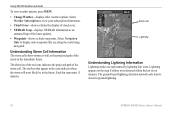
... on the map if strikes were detected within the last seven minutes. Select Navigation Only to view your subscription information. • Cloud Cover-shows or hides the display of cloud cover. • NEXRAD Loop-displays NEXRAD information as the projected path of the storm cell. Using XM WX Weather and Audio To... weather options. The red bars that are represented by lightning bolt icons. The ground-based lightning detection network only detects cloud-to-ground lightning. 62 GPSMAP 400/500 Series Owner's Manual Each bar represents 15 minutes.
... on the map if strikes were detected within the last seven minutes. Select Navigation Only to view your subscription information. • Cloud Cover-shows or hides the display of cloud cover. • NEXRAD Loop-displays NEXRAD information as the projected path of the storm cell. Using XM WX Weather and Audio To... weather options. The red bars that are represented by lightning bolt icons. The ground-based lightning detection network only detects cloud-to-ground lightning. 62 GPSMAP 400/500 Series Owner's Manual Each bar represents 15 minutes.
