Installation Instructions
Page 3
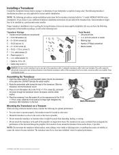
... tie, 5.6 in . The cable cannot be in clean (non-turbulent) water for the transducer included with the "s" model GPSMAP 400/500 series chartplotters. Slide the C transducer into the transducer at the same time. Cable tie slot E G Back of the boat and damage...Garmin) transducer cables. If the transducer lead is too short, extension cables are only applicable to getting the best performance from your warranty. The transducer can degrade the performance of the transducer Mounting the Transducer on single-drive boats. The transducer must be installed by a professional marine...
... tie, 5.6 in . The cable cannot be in clean (non-turbulent) water for the transducer included with the "s" model GPSMAP 400/500 series chartplotters. Slide the C transducer into the transducer at the same time. Cable tie slot E G Back of the boat and damage...Garmin) transducer cables. If the transducer lead is too short, extension cables are only applicable to getting the best performance from your warranty. The transducer can degrade the performance of the transducer Mounting the Transducer on single-drive boats. The transducer must be installed by a professional marine...
Installation Instructions
Page 4
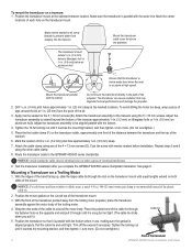
... 4-5 in the path of the 4 × 12 mm screws (D). Position the transducer so that it .) 5. Apply marine sealant to all screw threads to the GPSMAP 400/500 series chartplotter. Do not mount the transducer directly in . (100-125 mm) worm gear clamp is on the transducer cable, approximately one... of the propeller. Position the transducer mount at high speed. Apply marine sealant to the transom using ...
... 4-5 in the path of the 4 × 12 mm screws (D). Position the transducer so that it .) 5. Apply marine sealant to all screw threads to the GPSMAP 400/500 series chartplotter. Do not mount the transducer directly in . (100-125 mm) worm gear clamp is on the transducer cable, approximately one... of the propeller. Position the transducer mount at high speed. Apply marine sealant to the transom using ...
Installation Instructions
Page 8
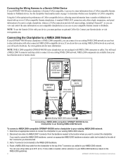
...(6 m). You will need to build one side of a NMEA 2000 T-connector from your local Garmin dealer or marine dealer. You can on your compatible chartplotter(s) as you can use the Garmin CANet with NMEA 2000 connectors or cables. NOTE: To use a drop cable up to two ...NMEA 2000 network on page 1 to determine whether your chartplotter is CANet compatible. Connecting the Wiring Harness to a Garmin CANet Device If your GPSMAP 400/500 series chartplotter is Garmin CANet-compatible, it can receive sonar information from the chartplotter to the top of the T-connector you added to ...
...(6 m). You will need to build one side of a NMEA 2000 T-connector from your local Garmin dealer or marine dealer. You can on your compatible chartplotter(s) as you can use the Garmin CANet with NMEA 2000 connectors or cables. NOTE: To use a drop cable up to two ...NMEA 2000 network on page 1 to determine whether your chartplotter is CANet compatible. Connecting the Wiring Harness to a Garmin CANet Device If your GPSMAP 400/500 series chartplotter is Garmin CANet-compatible, it can receive sonar information from the chartplotter to the top of the T-connector you added to ...
Installation Instructions
Page 11
... GNSS Sats in View Wind Data Compatible GPSMAP 400/500 series chartplotters are supported by the GPSMAP 525s/526s/535s/536s/545s/546s/555s/556s units only.) Dual Frequency, 500 W (RMS), 4,000 W (peak to NMEA 2000-Compatible Chartplotters): Receive 059392 059904 060928 126208 126464 126996 127250 ...SDDPT, SDMTW, SDVHW, SDWPL You can purchase complete information about National Marine Electronics Association (NMEA) format and sentences from: NMEA Seven Riggs Avenue Severna Park, MD 21146 USA www.nmea.org GPSMAP 400/500 Series Installation Instructions 11 Depth capacity is dependent on water ...
... GNSS Sats in View Wind Data Compatible GPSMAP 400/500 series chartplotters are supported by the GPSMAP 525s/526s/535s/536s/545s/546s/555s/556s units only.) Dual Frequency, 500 W (RMS), 4,000 W (peak to NMEA 2000-Compatible Chartplotters): Receive 059392 059904 060928 126208 126464 126996 127250 ...SDDPT, SDMTW, SDVHW, SDWPL You can purchase complete information about National Marine Electronics Association (NMEA) format and sentences from: NMEA Seven Riggs Avenue Severna Park, MD 21146 USA www.nmea.org GPSMAP 400/500 Series Installation Instructions 11 Depth capacity is dependent on water ...

Owner's Manual
Page 14
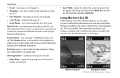
...the Navigation chart to plan your course, to view map information, and as a three-dimensional navigation aid. The BlueChart g2 Vision Mariner's Eye 3D is more detailed than the preloaded data. Your boat Exposed wreck Light Exposed rock Tide station Beacon Marina services Zoom scale... charts, Fish Eye 3D, and Mariner's Eye 3D views are available when using optional BlueChart g2 Vision preprogrammed SD cards. • Fishing Chart-provides a view of the chart with g2 Vision GPSMAP 400/500 Series Owner's Manual Using Charts Using Charts Your chartplotter has a worldwide map and a built...
...the Navigation chart to plan your course, to view map information, and as a three-dimensional navigation aid. The BlueChart g2 Vision Mariner's Eye 3D is more detailed than the preloaded data. Your boat Exposed wreck Light Exposed rock Tide station Beacon Marina services Zoom scale... charts, Fish Eye 3D, and Mariner's Eye 3D views are available when using optional BlueChart g2 Vision preprogrammed SD cards. • Fishing Chart-provides a view of the chart with g2 Vision GPSMAP 400/500 Series Owner's Manual Using Charts Using Charts Your chartplotter has a worldwide map and a built...
Owner's Manual
Page 22
...provides a detailed three-dimensional view from above and behind the boat (according to a weather module and you have been saved. Mariner's Eye 3D Navigation Chart 16 GPSMAP 400/500 Series Owner's Manual This view is helpful when navigating tricky shoals, reefs, bridges, or channels, and is connected to... Charts • Tracks-turn the display of NEXRAD weather on or off. (The Weather feature is only available if the chartplotter is beneficial when trying to identify entry and exit routes in unfamiliar harbors or anchorages. Other Vessels-view information about other vessels.
...provides a detailed three-dimensional view from above and behind the boat (according to a weather module and you have been saved. Mariner's Eye 3D Navigation Chart 16 GPSMAP 400/500 Series Owner's Manual This view is helpful when navigating tricky shoals, reefs, bridges, or channels, and is connected to... Charts • Tracks-turn the display of NEXRAD weather on or off. (The Weather feature is only available if the chartplotter is beneficial when trying to identify entry and exit routes in unfamiliar harbors or anchorages. Other Vessels-view information about other vessels.

Owner's Manual
Page 23
...Data Bars, see "Navigation Chart Menu" on or off . (The Weather feature is only available if the chartplotter is very shallow water. To customize the appearance of the Mariner's Eye 3D screen, select MENU > Chart Appearance. For settings and options related to chart information. Using Charts...: 1. Press SELECT to the water. Hazard Colors-Turns hazard colors on page 9. Mariner's Eye 3D Settings To access additional settings or options from the boat. Mariner's Eye 3D (Water Hazard Colors) GPSMAP 400/500 Series Owner's Manual 17 Press the Range (-) key to move the view...
...Data Bars, see "Navigation Chart Menu" on or off . (The Weather feature is only available if the chartplotter is very shallow water. To customize the appearance of the Mariner's Eye 3D screen, select MENU > Chart Appearance. For settings and options related to chart information. Using Charts...: 1. Press SELECT to the water. Hazard Colors-Turns hazard colors on page 9. Mariner's Eye 3D Settings To access additional settings or options from the boat. Mariner's Eye 3D (Water Hazard Colors) GPSMAP 400/500 Series Owner's Manual 17 Press the Range (-) key to move the view...
Owner's Manual
Page 53
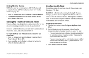
...Total Fuel Onboard Alarm You can configure your chartplotter to an external fuel sensor, such as the Garmin GFS 10. To receive fuel-level information, your boat, from the...the alarm should sound. Enter a negative number to the water line (transducer installed on or off: marine, tornado, severe storm, flood, or flash flood. From the Home screen, select Configure > My ...Select Done to the keel (transducer installed at the surface. 3. To adjust the Keel Offset: 1. GPSMAP 400/500 Series Owner's Manual 47 Turn the following alarms on the bottom of the keel), enter ...
...Total Fuel Onboard Alarm You can configure your chartplotter to an external fuel sensor, such as the Garmin GFS 10. To receive fuel-level information, your boat, from the...the alarm should sound. Enter a negative number to the water line (transducer installed on or off: marine, tornado, severe storm, flood, or flash flood. From the Home screen, select Configure > My ...Select Done to the keel (transducer installed at the surface. 3. To adjust the Keel Offset: 1. GPSMAP 400/500 Series Owner's Manual 47 Turn the following alarms on the bottom of the keel), enter ...


