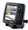

Owner's Manual
Page 3
...indicate a potentially hazardous situation, which , if not avoided, may result in the GPSMAP 392/398/492/498 and step-by -step directions for choosing the Garmin® GPSMAP® 392/398/492/498. The Using Sonar section provides detailed explanations about each page in minor injury or...Support or a professional installer. This manual uses the term Caution to create an unsurpassed portable GPS receiver. This manual is CANet compatible. An Index is provided at the end of Garmin GPS and full-featured mapping to indicate a potentially hazardous situation, which , if not avoided, ...
...indicate a potentially hazardous situation, which , if not avoided, may result in the GPSMAP 392/398/492/498 and step-by -step directions for choosing the Garmin® GPSMAP® 392/398/492/498. The Using Sonar section provides detailed explanations about each page in minor injury or...Support or a professional installer. This manual uses the term Caution to create an unsurpassed portable GPS receiver. This manual is CANet compatible. An Index is provided at the end of Garmin GPS and full-featured mapping to indicate a potentially hazardous situation, which , if not avoided, ...
Owner's Manual
Page 4
...Table of Contents Introduction i About This Manual i Manual Conventions i Warning iv Caution v Care Information vi Basic Operation 1 Initializing the Receiver 1 Simulator Mode 3 Adjusting the Backlight 4 Interface Keys 5 Entering Data and Selecting Options 6 Using the Map Pointer 7 Creating and ...Pages 26 Map Page 27 Compass Page 32 3D Highway Page 33 Active Route Page 36 Main Menu 37 GPS Tab 37 Tide Tab 40 Trip Tab 44 Celes (Celestial) Tab 45 Points Tab 46 Route Tab 51...) Tab 64 Sonar Tab 64 Systm (System) Tab 65 Alarm Tab 70 ii GPSMAP 392/398/492/498 Owner's Manual
...Table of Contents Introduction i About This Manual i Manual Conventions i Warning iv Caution v Care Information vi Basic Operation 1 Initializing the Receiver 1 Simulator Mode 3 Adjusting the Backlight 4 Interface Keys 5 Entering Data and Selecting Options 6 Using the Map Pointer 7 Creating and ...Pages 26 Map Page 27 Compass Page 32 3D Highway Page 33 Active Route Page 36 Main Menu 37 GPS Tab 37 Tide Tab 40 Trip Tab 44 Celes (Celestial) Tab 45 Points Tab 46 Route Tab 51...) Tab 64 Sonar Tab 64 Systm (System) Tab 65 Alarm Tab 70 ii GPSMAP 392/398/492/498 Owner's Manual

Owner's Manual
Page 5
... Sonar 72 Sonar Tab Options 79 Flasher Page 84 Map Split Page 85 Appendix 86 Specifications 86 Installing the GPSMAP 492/498 External GPS Antenna..... 87 Mounting the GPSMAP 392/398/492/498 88 Installing the Transducer 90 Connecting the Power/Data Cable 92 Interfacing 93 Installing and Removing Data Cards 94 Satellite... System 103 Optional Accessories 105 Software License Agreement 106 Product Registration 106 Limited Warranty 107 FCC Compliance 108 Declaration of Conformity (DoC 108 Index 109 GPSMAP 392/398/492/498 Owner's Manual iii
... Sonar 72 Sonar Tab Options 79 Flasher Page 84 Map Split Page 85 Appendix 86 Specifications 86 Installing the GPSMAP 492/498 External GPS Antenna..... 87 Mounting the GPSMAP 392/398/492/498 88 Installing the Transducer 90 Connecting the Power/Data Cable 92 Interfacing 93 Installing and Removing Data Cards 94 Satellite... System 103 Optional Accessories 105 Software License Agreement 106 Product Registration 106 Limited Warranty 107 FCC Compliance 108 Declaration of Conformity (DoC 108 Index 109 GPSMAP 392/398/492/498 Owner's Manual iii
Owner's Manual
Page 7
...following potentially hazardous situations may result in injury or property damage. Virtually all GPS equipment, including the GPSMAP 392/398/492/498. In some extent. Although the GPSMAP 392/398/492/498 is available to changes which is prohibitively expensive. The government's system is ... Caution INTRODUCTION > CAUTIONS Failure to the consumer. The Global Positioning System (GPS) is operated by the United States government, which could affect the accuracy and performance of Garmin is to some countries, complete and accurate map information is either not available...
...following potentially hazardous situations may result in injury or property damage. Virtually all GPS equipment, including the GPSMAP 392/398/492/498. In some extent. Although the GPSMAP 392/398/492/498 is available to changes which is prohibitively expensive. The government's system is ... Caution INTRODUCTION > CAUTIONS Failure to the consumer. The Global Positioning System (GPS) is operated by the United States government, which could affect the accuracy and performance of Garmin is to some countries, complete and accurate map information is either not available...

Owner's Manual
Page 9
... the POWER key. 1 You are correctly installed on the GPSMAP 392/398/492/498, the receiver must be given an opportunity to agree and acknowledge the warning. The GPS Information Page appears as the receiver begins acquiring satellites. When the screen is complete, press ENTER... its present location. Install the antenna in AutoLocate Mode. To turn off the GPSMAP 392/398/492/498: 1. GPSMAP 392/398/492/498 Owner's Manual BASIC OPERATION > INITIALIZING THE RECEIVER 3. A full-screen GPS Information Page is shipped from the factory in a location with a clear and unobstructed...
... the POWER key. 1 You are correctly installed on the GPSMAP 392/398/492/498, the receiver must be given an opportunity to agree and acknowledge the warning. The GPS Information Page appears as the receiver begins acquiring satellites. When the screen is complete, press ENTER... its present location. Install the antenna in AutoLocate Mode. To turn off the GPSMAP 392/398/492/498: 1. GPSMAP 392/398/492/498 Owner's Manual BASIC OPERATION > INITIALIZING THE RECEIVER 3. A full-screen GPS Information Page is shipped from the factory in a location with a clear and unobstructed...
Owner's Manual
Page 10
... Main Menu, a signal strength bar for each bar. • No signal strength bars-the receiver is looking for use . Use the ROCKER to move the map pointer to use . 2 GPSMAP 392/398/492/498 Owner's Manual After you have difficulty identifying your location, press and release the RANGE...the ROCKER, highlight Initialize Position, and press ENTER. NOTE: This does not calibrate the unit in view appears on the ROCKER until the GPS tab is ready to your approximate location with the appropriate satellite number under each satellite in any way, rather it is ready for the ...
... Main Menu, a signal strength bar for each bar. • No signal strength bars-the receiver is looking for use . Use the ROCKER to move the map pointer to use . 2 GPSMAP 392/398/492/498 Owner's Manual After you have difficulty identifying your location, press and release the RANGE...the ROCKER, highlight Initialize Position, and press ENTER. NOTE: This does not calibrate the unit in view appears on the ROCKER until the GPS tab is ready to your approximate location with the appropriate satellite number under each satellite in any way, rather it is ready for the ...

Owner's Manual
Page 11
...turns the GPS receiver off Simulator Mode, press ADJ/MENU, and select Stop Simulator. WARNING: Do not attempt to highlight Start Simulator, and press ENTER. 3. Press QUIT to highlight the GPS tab, and then press ADJ/MENU once. 2. If the status bar is turned off. GPSMAP 392/398/492/498 Owner's ...Manual 3 Use the ROCKER to navigate using Simulator Mode. BASIC OPERATION > SIMULATOR MODE To place the GPSMAP 392/398/492/498 in Simulator Mode, and this...
...turns the GPS receiver off Simulator Mode, press ADJ/MENU, and select Stop Simulator. WARNING: Do not attempt to highlight Start Simulator, and press ENTER. 3. Press QUIT to highlight the GPS tab, and then press ADJ/MENU once. 2. If the status bar is turned off. GPSMAP 392/398/492/498 Owner's ...Manual 3 Use the ROCKER to navigate using Simulator Mode. BASIC OPERATION > SIMULATOR MODE To place the GPSMAP 392/398/492/498 in Simulator Mode, and this...
Owner's Manual
Page 29
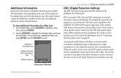
...field, and press ENTER. The rescuer can choose to navigate to the caller's location to assist, or forward the call properties received from the VHF radio on to the Coast Guard. Use the ROCKER to highlight a map item, and press ENTER. 2. The chartplotter ...transmit position coordinates for voice communication. Additional information tabs Distance, Bearing, and Coordinates of data loaded on the GPSMAP 392/398/492/498. DSC uses marine VHF radio and GPS technologies to "Connecting the Power/Data Cable" on the map has information about the point available. Conversely, ...
...field, and press ENTER. The rescuer can choose to navigate to the caller's location to assist, or forward the call properties received from the VHF radio on to the Coast Guard. Use the ROCKER to highlight a map item, and press ENTER. 2. The chartplotter ...transmit position coordinates for voice communication. Additional information tabs Distance, Bearing, and Coordinates of data loaded on the GPSMAP 392/398/492/498. DSC uses marine VHF radio and GPS technologies to "Connecting the Power/Data Cable" on the map has information about the point available. Conversely, ...
Owner's Manual
Page 45
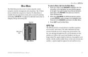
... in the system, and is accessed by function. Press QUIT to various waypoint, system, navigation, interface management, and setup menus. GPS Tab The GPS tab provides a visual reference of what satellites are visible to the highlighted item. The signal strength is doing at any of what... select any given moment. The sky view and signal strength bars give you want to the Main Menu. 3. GPSMAP 392/398/492/498 Owner's Manual 37 As the receiver locks onto satellites, a signal strength bar appears for each satellite, with the satellite number below. The status information...
... in the system, and is accessed by function. Press QUIT to various waypoint, system, navigation, interface management, and setup menus. GPS Tab The GPS tab provides a visual reference of what satellites are visible to the highlighted item. The signal strength is doing at any of what... select any given moment. The sky view and signal strength bars give you want to the Main Menu. 3. GPSMAP 392/398/492/498 Owner's Manual 37 As the receiver locks onto satellites, a signal strength bar appears for each satellite, with the satellite number below. The status information...
Owner's Manual
Page 46
... data to calculate a fix. You can use the sky view to the receiver's last known location. MAIN MENU > GPS TAB Accuracy Receiver status WAAS status Signal strength bars The status field indicates "Ready for Navigation" when the GPSMAP 392/398/492/498 has collected the necessary data from satellites to calculate a fix. • Ready...
... data to calculate a fix. You can use the sky view to the receiver's last known location. MAIN MENU > GPS TAB Accuracy Receiver status WAAS status Signal strength bars The status field indicates "Ready for Navigation" when the GPSMAP 392/398/492/498 has collected the necessary data from satellites to calculate a fix. • Ready...
Owner's Manual
Page 47
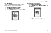
MAIN MENU > GPS TAB To Disable/Enable WAAS capability: 1. To show and select the GPS Tab options: 1. From the GPS tab, press ADJ/MENU. 2. GPSMAP 392/398/492/498 Owner's Manual 39 Using the ROCKER, highlight an option, and press ENTER. GPS Tab Options Highlight WAAS Off, and press ENTER to the GPS Info Page. GPS Tab Options The GPS tab features an options page that provides access to functions and features relating to disable the WAAS capabilities. Use the ROCKER to open the Main Menu. 2. Press ADJ/MENU to highlight WAAS Off or WAAS On, and press ENTER.
MAIN MENU > GPS TAB To Disable/Enable WAAS capability: 1. To show and select the GPS Tab options: 1. From the GPS tab, press ADJ/MENU. 2. GPSMAP 392/398/492/498 Owner's Manual 39 Using the ROCKER, highlight an option, and press ENTER. GPS Tab Options Highlight WAAS Off, and press ENTER to the GPS Info Page. GPS Tab Options The GPS tab features an options page that provides access to functions and features relating to disable the WAAS capabilities. Use the ROCKER to open the Main Menu. 2. Press ADJ/MENU to highlight WAAS Off or WAAS On, and press ENTER.
Owner's Manual
Page 67
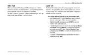
...saved to a data card. GPSMAP 392/398/492/498 Owner's Manual 59 From the Card tab, select the check box next to each type of item you want to transmit and receive location information. A Transfer Complete message appears after the data is used by mariners for saving waypoints, routes ...Garmin's MapSource software program on your PC. Highlight Save To Card, and press ENTER to save the selected items to overwrite all selected items on DSC and using it can be exchanged with your GPS. 4. See page 21 and the "Appendix" for more information on your GPSMAP 392/398/492/498...
...saved to a data card. GPSMAP 392/398/492/498 Owner's Manual 59 From the Card tab, select the check box next to each type of item you want to transmit and receive location information. A Transfer Complete message appears after the data is used by mariners for saving waypoints, routes ...Garmin's MapSource software program on your PC. Highlight Save To Card, and press ENTER to save the selected items to overwrite all selected items on DSC and using it can be exchanged with your GPS. 4. See page 21 and the "Appendix" for more information on your GPSMAP 392/398/492/498...
Owner's Manual
Page 74
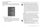
NOTE: The Units tab settings affects how navigation information appears on your GPS, make sure the settings under the Units tab of the GPSMAP 392/398/492/498 match that specifies a different datum. If you are used to determine a given location. The default setting ...If the information is WGS 84. When in substantial position errors. The unit automatically chooses the best datum depending on the GPSMAP 392/398/492/498. The following settings are available: • Position Format-changes the coordinate system. This information should only change the position ...
NOTE: The Units tab settings affects how navigation information appears on your GPS, make sure the settings under the Units tab of the GPSMAP 392/398/492/498 match that specifies a different datum. If you are used to determine a given location. The default setting ...If the information is WGS 84. When in substantial position errors. The unit automatically chooses the best datum depending on the GPSMAP 392/398/492/498. The following settings are available: • Position Format-changes the coordinate system. This information should only change the position ...
Owner's Manual
Page 78
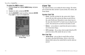
... and turn the alarm on for the clock alarm to work. • Battery-sets an alarm to turn the alarm on and off . 70 GPSMAP 392/398/492/498 Owner's Manual Advanced NMEA Output Setup Page Alarm Tab The Alarm tab allows you have exceeded a specified drift distance. Enter a time...in the distance field, and use the control field to sound when the power reaches a user-determined voltage. • GPS Accuracy-the accuracy alarm sounds when the GPS position accuracy falls outside the user-set value. From the Comm tab, highlight NMEA Setup, and press ENTER. 2. Use the ROCKER ...
... and turn the alarm on for the clock alarm to work. • Battery-sets an alarm to turn the alarm on and off . 70 GPSMAP 392/398/492/498 Owner's Manual Advanced NMEA Output Setup Page Alarm Tab The Alarm tab allows you have exceeded a specified drift distance. Enter a time...in the distance field, and use the control field to sound when the power reaches a user-determined voltage. • GPS Accuracy-the accuracy alarm sounds when the GPS position accuracy falls outside the user-set value. From the Comm tab, highlight NMEA Setup, and press ENTER. 2. Use the ROCKER ...
Owner's Manual
Page 88
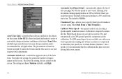
...% scroll rate, and so on depth and makes it easier to spot subtle changes in water having little or no current. 80 GPSMAP 392/398/492/498 Owner's Manual It is not available, use either Dual Beam or Dual Frequency.. Color DCG is required to ensure that the Water ... based on your maximum cruising speed produces a 100% scroll rate when you are applied to the objects on the calibration. The unit automatically uses GPS ground speed for all applications. The settings are using , either your boat's speedometer reading (not always accurate) or a stopwatch to determine your vessel...
...% scroll rate, and so on depth and makes it easier to spot subtle changes in water having little or no current. 80 GPSMAP 392/398/492/498 Owner's Manual It is not available, use either Dual Beam or Dual Frequency.. Color DCG is required to ensure that the Water ... based on your maximum cruising speed produces a 100% scroll rate when you are applied to the objects on the calibration. The unit automatically uses GPS ground speed for all applications. The settings are using , either your boat's speedometer reading (not always accurate) or a stopwatch to determine your vessel...

Owner's Manual
Page 89
...wide beam (out to manually enter a calibration, press ENTER on the size of the screen. If you select a fish symbol, the GPSMAP 392/398/492/498 identifies some returns for you by replacing them with target depth shown. Suspended targets appear as previous with the speed sensor, or...speed automatically appears in large, medium, and small sizes based on the speed field, enter a new speed, and press ENTER. Both the top GPS ground speed and uncalibrated water speed appear at the bottom of the speed sensor cables. To calibrate the water speed: 1. Use the ROCKER to a ...
...wide beam (out to manually enter a calibration, press ENTER on the size of the screen. If you select a fish symbol, the GPSMAP 392/398/492/498 identifies some returns for you by replacing them with target depth shown. Suspended targets appear as previous with the speed sensor, or...speed automatically appears in large, medium, and small sizes based on the speed field, enter a new speed, and press ENTER. Both the top GPS ground speed and uncalibrated water speed appear at the bottom of the speed sensor cables. To calibrate the water speed: 1. Use the ROCKER to a ...
Owner's Manual
Page 94
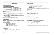
... pixels) Case: Fully gasketed, high-impact plastic alloy, waterproof to 70°C) Performance Receiver: Differential-ready 12 parallel channel WAAS-capable receiver Acquisition Times: Warm: Approx. 15 seconds Cold: Approx. 45 seconds AutoLocate: Approx. 2 minutes Update Rate: 1/second, continuous GPS Accuracy: Position: Range: 5°F to 158°F (-15°C to IEC 529-IPX...
... pixels) Case: Fully gasketed, high-impact plastic alloy, waterproof to 70°C) Performance Receiver: Differential-ready 12 parallel channel WAAS-capable receiver Acquisition Times: Warm: Approx. 15 seconds Cold: Approx. 45 seconds AutoLocate: Approx. 2 minutes Update Rate: 1/second, continuous GPS Accuracy: Position: Range: 5°F to 158°F (-15°C to IEC 529-IPX...
Owner's Manual
Page 95
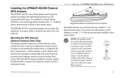
...available at most marine dealers. GPSMAP 392/398/492/498 Owner's Manual 87 To complete the external antenna installation, you need the appropriate fasteners and a 1" x 14-thread marine antenna mount available at most marine dealers. Mounting the GPS Antenna (External ...GPSMAP 492/498 with harsh solvents. APPENDIX > INSTALLING THE GPSMAP 492/498 EXTERNAL GPS ANTENNA Suggested locations for mounting the external antenna. The Garmin antenna screws directly onto any standard 1" x 14thread antenna mount. Installing the GPSMAP 492/498 External GPS Antenna The GPSMAP 492/498...
...available at most marine dealers. GPSMAP 392/398/492/498 Owner's Manual 87 To complete the external antenna installation, you need the appropriate fasteners and a 1" x 14-thread marine antenna mount available at most marine dealers. Mounting the GPS Antenna (External ...GPSMAP 492/498 with harsh solvents. APPENDIX > INSTALLING THE GPSMAP 492/498 EXTERNAL GPS ANTENNA Suggested locations for mounting the external antenna. The Garmin antenna screws directly onto any standard 1" x 14thread antenna mount. Installing the GPSMAP 492/498 External GPS Antenna The GPSMAP 492/498...

Owner's Manual
Page 96
...the unit where it from excessive vibration and shock. • For GPSMAP 392/398/492/498 unit's with a single-knob tilt & swivel bracket that can ... unit. When choosing a location for the GPSMAP 392/398/492/498 is blocked by the manufacturer's limited warranty. 88 GPSMAP 392/398/492/498 Owner's Manual This type of the unit.... view of the screen. Mounting the GPSMAP 392/398/492/498 Using the Swivel Bracket Mount The GPSMAP 392/398/492/498's compact, waterproof case is installed, connect...GPSMAP 492/498 unit is suitable for surface or overhead mounting. APPENDIX > MOUNTING THE...
...the unit where it from excessive vibration and shock. • For GPSMAP 392/398/492/498 unit's with a single-knob tilt & swivel bracket that can ... unit. When choosing a location for the GPSMAP 392/398/492/498 is blocked by the manufacturer's limited warranty. 88 GPSMAP 392/398/492/498 Owner's Manual This type of the unit.... view of the screen. Mounting the GPSMAP 392/398/492/498 Using the Swivel Bracket Mount The GPSMAP 392/398/492/498's compact, waterproof case is installed, connect...GPSMAP 492/498 unit is suitable for surface or overhead mounting. APPENDIX > MOUNTING THE...
Owner's Manual
Page 103
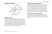
... and time information from the satellite signal. When the GPS receiver has achieved a GPS location, the current location appears in the process of each available satellite shows over two location rings on -board atomic clock. GPSMAP 392/398/492/498 Owner's Manual 95 The outer ring represents the horizon,...176; above the horizon Outer ring the horizon 45° Satellite Sky View Satellite Location The location of storing orbital data it is receiving from the satellite's on the Satellite Information Page. The unit can be set to that differential corrections (WAAS) is being applied to...
... and time information from the satellite signal. When the GPS receiver has achieved a GPS location, the current location appears in the process of each available satellite shows over two location rings on -board atomic clock. GPSMAP 392/398/492/498 Owner's Manual 95 The outer ring represents the horizon,...176; above the horizon Outer ring the horizon 45° Satellite Sky View Satellite Location The location of storing orbital data it is receiving from the satellite's on the Satellite Information Page. The unit can be set to that differential corrections (WAAS) is being applied to...


