Owner's Manual (for Europe)
Page 5
...Sequence 86 Navigating in Marine Mode 87 Marine Mode Pages and Features 88 Map Page 88 Compass Page 89 DSC 91 Main Menu 96 GPS Tab 96 Flights Tab 96 Route Tab 97 Points Tab 97 Track Tab 97 Sonar Tab 98 Aircraft Tab 98 Alarms Tab 99 ... Accessories 133 Installation Information 134 Declaration of Conformity (DoC 138 Learning About GPS 139 LORAN TD Setup 140 Map Datums and Location Formats 142 Digital Selective Calling (DSC 143 Jeppesen Database Information 144 Messages 145 Data Field Options 147 License Agreement and Warranty 149 Index 151 GPSMAP 496 Owner's Manual iii
...Sequence 86 Navigating in Marine Mode 87 Marine Mode Pages and Features 88 Map Page 88 Compass Page 89 DSC 91 Main Menu 96 GPS Tab 96 Flights Tab 96 Route Tab 97 Points Tab 97 Track Tab 97 Sonar Tab 98 Aircraft Tab 98 Alarms Tab 99 ... Accessories 133 Installation Information 134 Declaration of Conformity (DoC 138 Learning About GPS 139 LORAN TD Setup 140 Map Datums and Location Formats 142 Digital Selective Calling (DSC 143 Jeppesen Database Information 144 Messages 145 Data Field Options 147 License Agreement and Warranty 149 Index 151 GPSMAP 496 Owner's Manual iii

Owner's Manual (for Europe)
Page 9
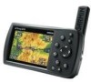
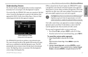
...receive satellite signals. Be sure the antenna is easy to read in bright sun, a built-in -one, versatile color aviation, automotive, and marine navigator-perfect for air, land, or water. Refer to provide you with backlighting Backlit keypad for easy nighttime operation GPSMAP 496 Owner's Manual Detachable GPS...portable GPS navigator features a 256-color TFT screen that is up (as shown here) to remove battery pack for replacement, if necessary. Getting Started Getting Started > Unit Overview Unit Overview The GPSMAP 496 is an all-in City Navigator basemap, Jeppesen aviation database,...
...receive satellite signals. Be sure the antenna is easy to read in bright sun, a built-in -one, versatile color aviation, automotive, and marine navigator-perfect for air, land, or water. Refer to provide you with backlighting Backlit keypad for easy nighttime operation GPSMAP 496 Owner's Manual Detachable GPS...portable GPS navigator features a 256-color TFT screen that is up (as shown here) to remove battery pack for replacement, if necessary. Getting Started Getting Started > Unit Overview Unit Overview The GPSMAP 496 is an all-in City Navigator basemap, Jeppesen aviation database,...
Owner's Manual (for Europe)
Page 18
Getting Started > Using the GPSMAP 496 To enter data in City Navigator street and points of interest mapping, Jeppesen® database, Obstacle database, Terrain database, and Voice Guidance database. Press up or down on the ROCKER. Refer to the Garmin Web site at www.garmin.com/cartography. The included USB Interface Cable or an optional PC Interface Cable (with...
Getting Started > Using the GPSMAP 496 To enter data in City Navigator street and points of interest mapping, Jeppesen® database, Obstacle database, Terrain database, and Voice Guidance database. Press up or down on the ROCKER. Refer to the Garmin Web site at www.garmin.com/cartography. The included USB Interface Cable or an optional PC Interface Cable (with...
Owner's Manual (for Europe)
Page 22
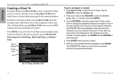
... Press ENTER when the point is currently in Aviation Mode > Creating a Direct To Creating a Direct To In Aviation Mode, press Direct To to select a destination. Go To Page: Aviation Tab 14 GPSMAP 496 Owner's Manual Use the ROCKER to show the Aviation tab. 2. Press Direct To to show the...window appears. With the on the tab you selected, you to an airport or navaid: 1. As you scroll through the characters the GPSMAP 496 shows database entries with the same characters you have entered to select the identifier, facility name, or city field, and press ENTER. 3. In...
... Press ENTER when the point is currently in Aviation Mode > Creating a Direct To Creating a Direct To In Aviation Mode, press Direct To to select a destination. Go To Page: Aviation Tab 14 GPSMAP 496 Owner's Manual Use the ROCKER to show the Aviation tab. 2. Press Direct To to show the...window appears. With the on the tab you selected, you to an airport or navaid: 1. As you scroll through the characters the GPSMAP 496 shows database entries with the same characters you have entered to select the identifier, facility name, or city field, and press ENTER. 3. In...

Owner's Manual (for Europe)
Page 30
Keep in mind that the airport must have a published approach (GPS, RNAV, VOR, NDB, localizer, or ILS) and only the final course segment (usually from final approach fix to the right. • From the Active Go ... to open the options menu. Aviation Basic Operation in Aviation Mode > Selecting an Approach Selecting an Approach Caution: The approaches provided in the Route tab. Select the destination you select an approach, it with the sequence of navigation guidance in the GPSMAP 496. The GPSMAP 496 is saved in the Jeppesen database are for the destination airport...
Keep in mind that the airport must have a published approach (GPS, RNAV, VOR, NDB, localizer, or ILS) and only the final course segment (usually from final approach fix to the right. • From the Active Go ... to open the options menu. Aviation Basic Operation in Aviation Mode > Selecting an Approach Selecting an Approach Caution: The approaches provided in the Route tab. Select the destination you select an approach, it with the sequence of navigation guidance in the GPSMAP 496. The GPSMAP 496 is saved in the Jeppesen database are for the destination airport...
Owner's Manual (for Europe)
Page 31
... waypoint in the approach (from point to the inbound course. GPSMAP 496 Owner's Manual Basic Operation in the approach The GPSMAP 496 provides no guidance to the first waypoint in the database (final approach fix [FAF]). option, the GPSMAP 496 creates a straight-line course directly to the inbound course. If...HSI remains off-center until you select Yes, the GPSMAP 496 creates an extension of the final approach course using a bold magenta line. Follow the approach plate or air traffic control instructions to the FAF. 23 Aviation option, which appears after you select an approach, ...
... waypoint in the approach (from point to the inbound course. GPSMAP 496 Owner's Manual Basic Operation in the approach The GPSMAP 496 provides no guidance to the first waypoint in the database (final approach fix [FAF]). option, the GPSMAP 496 creates a straight-line course directly to the inbound course. If...HSI remains off-center until you select Yes, the GPSMAP 496 creates an extension of the final approach course using a bold magenta line. Follow the approach plate or air traffic control instructions to the FAF. 23 Aviation option, which appears after you select an approach, ...
Owner's Manual (for Europe)
Page 34
...: 1. For more information, refer to "Creating Routes" beginning on page 56 and "Editing and Managing Routes" beginning on page 69. GPSMAP 496 Owner's Manual Aviation Basic Operation in Aviation Mode > Creating a Flight Plan (Route) Creating a Flight Plan (Route) You can also create a flight plan to use . For...highlight Add Waypoint, and press Enter. To create a route: 1. Use the ROCKER to create a new route with current Jeppesen Database points. The Aviation Find Page (Go To Page) opens allowing you want to the unit's memory. Highlight a blank line and press Enter to select ...
...: 1. For more information, refer to "Creating Routes" beginning on page 56 and "Editing and Managing Routes" beginning on page 69. GPSMAP 496 Owner's Manual Aviation Basic Operation in Aviation Mode > Creating a Flight Plan (Route) Creating a Flight Plan (Route) You can also create a flight plan to use . For...highlight Add Waypoint, and press Enter. To create a route: 1. Use the ROCKER to create a new route with current Jeppesen Database points. The Aviation Find Page (Go To Page) opens allowing you want to the unit's memory. Highlight a blank line and press Enter to select ...

Owner's Manual (for Europe)
Page 35
Aviation Following your Flight Plan When you have created and started your flight plan (or route), the GPSMAP 496 guides you to the destination using a variety of your flight. If there is a graphic view of tools. You can view any terrain and obstacles that might become a problem to your Jeppesen Database, verify... line as you are directly on the Panel Page You can help keep the aircraft within the VNAV profile when viewing the VNAV indicator. GPSMAP 496 Owner's Manual 27 When you are on the magenta line, you move. Terrain and obstacles that all of your flight plans (routes) ...
Aviation Following your Flight Plan When you have created and started your flight plan (or route), the GPSMAP 496 guides you to the destination using a variety of your flight. If there is a graphic view of tools. You can view any terrain and obstacles that might become a problem to your Jeppesen Database, verify... line as you are directly on the Panel Page You can help keep the aircraft within the VNAV profile when viewing the VNAV indicator. GPSMAP 496 Owner's Manual 27 When you are on the magenta line, you move. Terrain and obstacles that all of your flight plans (routes) ...
Owner's Manual (for Europe)
Page 50
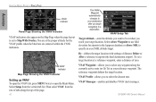
You are at the proper altitude for airports in the Jeppesen database or Above MSL to open the VNAV tab, press Menu twice to specify an exact MSL altitude target. VNAV Setup Tab Target Altitude-enter the ... your destination after you to Map With Overlay. Aviation Aviation Mode Pages > Panel Page VNAV Indicator Panel Page Showing the VNAV Indicator VNAV indicators also appear on the Map Page when the page layout is set a target location at a reference waypoint, enter a distance of zero. GPSMAP 496 Owner's Manual To set to select any...
You are at the proper altitude for airports in the Jeppesen database or Above MSL to open the VNAV tab, press Menu twice to specify an exact MSL altitude target. VNAV Setup Tab Target Altitude-enter the ... your destination after you to Map With Overlay. Aviation Aviation Mode Pages > Panel Page VNAV Indicator Panel Page Showing the VNAV Indicator VNAV indicators also appear on the Map Page when the page layout is set a target location at a reference waypoint, enter a distance of zero. GPSMAP 496 Owner's Manual To set to select any...

Owner's Manual (for Europe)
Page 51
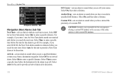
... Route)-allows you to open the Active Route Page. GPSMAP 496 Owner's Manual 43 Active Route Page Note: If you have created a route (Flight Plan) with an arrow. Aviation Mode Pages > Active Route Page Active Route Page Options Press Menu while on existing GPS, RNAV, VOR, NDB, localizer, or ILS approach ... Map (see page 72 for your landing and set your fuel flow (or plan your current Usage Mode): Select Approach-(Aviation Only) allows you to your Jeppesen Database, the route is locked. The Active Route and Route Review Pages share many of information. You need to suit your aircraft...
... Route)-allows you to open the Active Route Page. GPSMAP 496 Owner's Manual 43 Active Route Page Note: If you have created a route (Flight Plan) with an arrow. Aviation Mode Pages > Active Route Page Active Route Page Options Press Menu while on existing GPS, RNAV, VOR, NDB, localizer, or ILS approach ... Map (see page 72 for your landing and set your fuel flow (or plan your current Usage Mode): Select Approach-(Aviation Only) allows you to your Jeppesen Database, the route is locked. The Active Route and Route Review Pages share many of information. You need to suit your aircraft...

Owner's Manual (for Europe)
Page 99
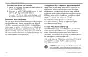
..., refer to control and set up the Digital Selective Calling (DSC) features on the GPSMAP 496. The chartplotter repeats the call properties received from a distress call on an electronic map. The GPSMAP 496 requires input from a DSC enabled VHF radio to show position, and to exchange and...number. DSC uses marine VHF radio and GPS technologies to "Connecting the Power/ Data Cable" on the chartplotter. For connection information, refer to transmit and receive location information. In order to use DSC, users must first register their database while they are in a single transmission ...
..., refer to control and set up the Digital Selective Calling (DSC) features on the GPSMAP 496. The chartplotter repeats the call properties received from a distress call on an electronic map. The GPSMAP 496 requires input from a DSC enabled VHF radio to show position, and to exchange and...number. DSC uses marine VHF radio and GPS technologies to "Connecting the Power/ Data Cable" on the chartplotter. For connection information, refer to transmit and receive location information. In order to use DSC, users must first register their database while they are in a single transmission ...
Owner's Manual (for Europe)
Page 108
... the alarm to sound when you have entered the proximity of the safety camera or other custom POI database. 100 GPSMAP 496 Owner's Manual Caution: Garmin is not responsible for the consequences of using a custom POI database or the accuracy of a custom POI. Arrival-sets an alarm to go off. Anchor Drag-sets an alarm...
... the alarm to sound when you have entered the proximity of the safety camera or other custom POI database. 100 GPSMAP 496 Owner's Manual Caution: Garmin is not responsible for the consequences of using a custom POI database or the accuracy of a custom POI. Arrival-sets an alarm to go off. Anchor Drag-sets an alarm...
Owner's Manual (for Europe)
Page 144
... and waypoint symbols from various companies on your GPS unit. The POI Loader is connected. After the drivers are updated periodically. You can find these points. (Automotive Mode Only) After downloading your POI database, use the Garmin POI loader to install the POIs to your GPSMAP 496. Caution: Garmin is not responsible for points such as...
... and waypoint symbols from various companies on your GPS unit. The POI Loader is connected. After the drivers are updated periodically. You can find these points. (Automotive Mode Only) After downloading your POI database, use the Garmin POI loader to install the POIs to your GPSMAP 496. Caution: Garmin is not responsible for points such as...

Owner's Manual (for Europe)
Page 151
... MMSI number acts like a phone. How Can Garmin Help You with the International Telecommunications Union or the local ... database while they are and the type of information in a single transmission or "call , if the receiver ...received location on to transmit and receive location information. To receive distress calls or position reports, you can choose to navigate (Go To) the caller's location to GPSMAP 496...receive a Maritime Mobile Service Identity (MMSI) number. Digital Selective Calling (DSC) Digital Selective Calling (DSC) uses marine VHF radio and Global Positioning System (GPS...
... MMSI number acts like a phone. How Can Garmin Help You with the International Telecommunications Union or the local ... database while they are and the type of information in a single transmission or "call , if the receiver ...received location on to transmit and receive location information. To receive distress calls or position reports, you can choose to navigate (Go To) the caller's location to GPSMAP 496...receive a Maritime Mobile Service Identity (MMSI) number. Digital Selective Calling (DSC) Digital Selective Calling (DSC) uses marine VHF radio and Global Positioning System (GPS...
Owner's Manual (for Europe)
Page 152
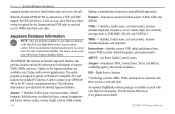
... a saved route, the route is connected to a VHF with your GPSMAP 496 to send and receive NMEA data from the internal Jeppesen database: Airport-* identifier, facility name, city/state/country, latitude/ longitude, ...Garmin Web site at www.garmin.com/aviation. Weather-frequencies associated with current Jeppesen database points. An optional FlightBook software package is designed to assist with DSC support, the GPS unit shows a Call List, Log, and a Directory. The update program is available to operate on a sectional chart. GPSMAP 496 Owner's Manual When the Garmin GPSMAP 496...
... a saved route, the route is connected to a VHF with your GPSMAP 496 to send and receive NMEA data from the internal Jeppesen database: Airport-* identifier, facility name, city/state/country, latitude/ longitude, ...Garmin Web site at www.garmin.com/aviation. Weather-frequencies associated with current Jeppesen database points. An optional FlightBook software package is designed to assist with DSC support, the GPS unit shows a Call List, Log, and a Directory. The update program is available to operate on a sectional chart. GPSMAP 496 Owner's Manual When the Garmin GPSMAP 496...

Owner's Manual (for Europe)
Page 153
...received. The unit shows an icon and beeps (if enabled). All MapSource maps are loaded on the data card do not support automatic route calculation. Contact Garmin Product Support to have the unit serviced. No Diff GPS...Garmin Product Support to have the unit serviced. Contact your destination. Memory (RAM) Failed Unit Needs Repair-there is an internal problem with your unit. No DGPS Position-no further data can be recharged. GPSMAP 496... has been received from the external sonar device. Deep Water-the water is not near any roads. Database Error-internal ...
...received. The unit shows an icon and beeps (if enabled). All MapSource maps are loaded on the data card do not support automatic route calculation. Contact Garmin Product Support to have the unit serviced. No Diff GPS...Garmin Product Support to have the unit serviced. Contact your destination. Memory (RAM) Failed Unit Needs Repair-there is an internal problem with your unit. No DGPS Position-no further data can be recharged. GPSMAP 496... has been received from the external sonar device. Deep Water-the water is not near any roads. Database Error-internal ...
Owner's Manual (for Europe)
Page 160
... Item in automotive or marine mode 53-55 finding a nearby aviation point 17-21 fishing information 106 fish symbols 124 flasher 126 FlightBook...follow roads 57 FSS 17 fuel flow 43, 46, 72 G GARMIN DGPS 116 getting satellite signals 4-6 going to a destination 51 go ... call 95 history 54 page 15, 22 point 87 position report 95 GPS 139 learning about 139 Off/On 5 page 6, 69 GRI chain 141...31, 55 initialize 3 installation information 134-137 intersection 144 J Jeppesen database 26, 144 updates 10 GPSMAP 496 Owner's Manual Index D dashboard 68 data card 137 slot 1 data ...
... Item in automotive or marine mode 53-55 finding a nearby aviation point 17-21 fishing information 106 fish symbols 124 flasher 126 FlightBook...follow roads 57 FSS 17 fuel flow 43, 46, 72 G GARMIN DGPS 116 getting satellite signals 4-6 going to a destination 51 go ... call 95 history 54 page 15, 22 point 87 position report 95 GPS 139 learning about 139 Off/On 5 page 6, 69 GRI chain 141...31, 55 initialize 3 installation information 134-137 intersection 144 J Jeppesen database 26, 144 updates 10 GPSMAP 496 Owner's Manual Index D dashboard 68 data card 137 slot 1 data ...
Owner's Manual (for Europe)
Page 163
... turn-by-turn route 51, 61, 70 turn on terrain 36 Z zoom 29 U underwater waypoints 123 Units tab 113 unpaved roads 111 updates to jeppesen database 144 usage mode 13, 109 usage restrictions 16 USB 115 data cable 136 User Points tab 78 UTC 113 UTM/UPS 142 W Warning Page 3 waterproof..., 58-60 categories 77, 78 create 25, 59, 76 edit 73, 74 Information Page 55 manage 73 mark 25 name 74 proximity 81 symbol 74 GPSMAP 496 Owner's Manual 155
... turn-by-turn route 51, 61, 70 turn on terrain 36 Z zoom 29 U underwater waypoints 123 Units tab 113 unpaved roads 111 updates to jeppesen database 144 usage mode 13, 109 usage restrictions 16 USB 115 data cable 136 User Points tab 78 UTC 113 UTM/UPS 142 W Warning Page 3 waterproof..., 58-60 categories 77, 78 create 25, 59, 76 edit 73, 74 Information Page 55 manage 73 mark 25 name 74 proximity 81 symbol 74 GPSMAP 496 Owner's Manual 155

Owner's Manual (for North America)
Page 6
Introduction > Table of Contents Appendix 155 Specifications 155 Care Information 156 Optional Accessories 157 Installation Information 158 Learning About GPS 163 LORAN TD Setup 165 Map Datums and Location Formats 167 Digital Selective Calling (DSC 168 Jeppesen Database Information 170 Messages 171 Data Field Options 174 License Agreement and Warranty 177 Index 181 iv GPSMAP 496 Owner's Manual
Introduction > Table of Contents Appendix 155 Specifications 155 Care Information 156 Optional Accessories 157 Installation Information 158 Learning About GPS 163 LORAN TD Setup 165 Map Datums and Location Formats 167 Digital Selective Calling (DSC 168 Jeppesen Database Information 170 Messages 171 Data Field Options 174 License Agreement and Warranty 177 Index 181 iv GPSMAP 496 Owner's Manual

Owner's Manual (for North America)
Page 9
...in City Navigator basemap, AOPA Airport Directory, SafeTaxi Airport Diagrams, Jeppesen aviation database, and auto routing to provide you with backlighting Detachable GPS antenna collapses for storage. In addition, the GPSMAP 496 offers XM Satellite Radio capabilities, featuring more than 150 digital channels of...news, sports, talk and entertainment; GPS antenna 256-Color TFT screen with automatically generated turn-by-turn directions. Getting Started > Unit Overview Getting Started Unit Overview The GPSMAP 496 is up (as shown here) to receive satellite signals. Refer to page 162...
...in City Navigator basemap, AOPA Airport Directory, SafeTaxi Airport Diagrams, Jeppesen aviation database, and auto routing to provide you with backlighting Detachable GPS antenna collapses for storage. In addition, the GPSMAP 496 offers XM Satellite Radio capabilities, featuring more than 150 digital channels of...news, sports, talk and entertainment; GPS antenna 256-Color TFT screen with automatically generated turn-by-turn directions. Getting Started > Unit Overview Getting Started Unit Overview The GPSMAP 496 is up (as shown here) to receive satellite signals. Refer to page 162...

