
Owner's Manual
Page 3
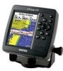
...Sonar section provides detailed explanations about the Main Menu and how to use it to create an unsurpassed portable GPS receiver. Before you with the GPSMAP 392/398/492/498, review the installation instructions listed in detail. The Introduction section contains the Table of this manual and... i This manual is CANet compatible. The GPSMAP 392/398/492/498 utilizes the proven performance of the manual for choosing the Garmin® GPSMAP® 392/398/492/498. An Index is provided at the end of Garmin GPS and full-featured mapping to configure your unit. This ...
...Sonar section provides detailed explanations about the Main Menu and how to use it to create an unsurpassed portable GPS receiver. Before you with the GPSMAP 392/398/492/498, review the installation instructions listed in detail. The Introduction section contains the Table of this manual and... i This manual is CANet compatible. The GPSMAP 392/398/492/498 utilizes the proven performance of the manual for choosing the Garmin® GPSMAP® 392/398/492/498. An Index is provided at the end of Garmin GPS and full-featured mapping to configure your unit. This ...
Owner's Manual
Page 4
... iv Caution v Care Information vi Basic Operation 1 Initializing the Receiver 1 Simulator Mode 3 Adjusting the Backlight 4 Interface Keys 5 Entering Data and Selecting Options 6 Using the Map Pointer 7 Creating and Using Waypoints 8 Man OverBoard (MOB 10...Calling 21 AIS 25 Main Pages 26 Map Page 27 Compass Page 32 3D Highway Page 33 Active Route Page 36 Main Menu 37 GPS Tab 37 Tide Tab 40 Trip Tab...60 Pages Tab 61 Map Tab 61 Hiway (Highway) Tab 64 Temp (Temperature) Tab 64 Sonar Tab 64 Systm (System) Tab 65 Alarm Tab 70 ii GPSMAP 392/398/492/498 Owner's Manual
... iv Caution v Care Information vi Basic Operation 1 Initializing the Receiver 1 Simulator Mode 3 Adjusting the Backlight 4 Interface Keys 5 Entering Data and Selecting Options 6 Using the Map Pointer 7 Creating and Using Waypoints 8 Man OverBoard (MOB 10...Calling 21 AIS 25 Main Pages 26 Map Page 27 Compass Page 32 3D Highway Page 33 Active Route Page 36 Main Menu 37 GPS Tab 37 Tide Tab 40 Trip Tab...60 Pages Tab 61 Map Tab 61 Hiway (Highway) Tab 64 Temp (Temperature) Tab 64 Sonar Tab 64 Systm (System) Tab 65 Alarm Tab 70 ii GPSMAP 392/398/492/498 Owner's Manual

Owner's Manual
Page 5
Using Sonar 72 Understanding Sonar 72 Sonar Tab Options 79 Flasher Page 84 Map Split Page 85 Appendix 86 Specifications 86 Installing the GPSMAP 492/498 External GPS Antenna..... 87 Mounting the GPSMAP 392/398/492/498 88 Installing the Transducer 90 Connecting the Power/Data Cable 92 Interfacing 93 Installing and Removing Data Cards... System 103 Optional Accessories 105 Software License Agreement 106 Product Registration 106 Limited Warranty 107 FCC Compliance 108 Declaration of Conformity (DoC 108 Index 109 GPSMAP 392/398/492/498 Owner's Manual iii
Using Sonar 72 Understanding Sonar 72 Sonar Tab Options 79 Flasher Page 84 Map Split Page 85 Appendix 86 Specifications 86 Installing the GPSMAP 492/498 External GPS Antenna..... 87 Mounting the GPSMAP 392/398/492/498 88 Installing the Transducer 90 Connecting the Power/Data Cable 92 Interfacing 93 Installing and Removing Data Cards... System 103 Optional Accessories 105 Software License Agreement 106 Product Registration 106 Limited Warranty 107 FCC Compliance 108 Declaration of Conformity (DoC 108 Index 109 GPSMAP 392/398/492/498 Owner's Manual iii
Owner's Manual
Page 6
... to mariners contain all available navigation sources, including information from visual sightings, and maps. WARNING: This product, its packaging, and its components contain chemicals known to navigate safely. INTRODUCTION > WARNINGS Warning Failure to our Web site at http://www.garmin.com/prop65. When navigating, carefully compare information displayed on the GPSMAP 392/398/492/498...
... to mariners contain all available navigation sources, including information from visual sightings, and maps. WARNING: This product, its packaging, and its components contain chemicals known to navigate safely. INTRODUCTION > WARNINGS Warning Failure to our Web site at http://www.garmin.com/prop65. When navigating, carefully compare information displayed on the GPSMAP 392/398/492/498...
Owner's Manual
Page 7
...GPS equipment, including the GPSMAP 392/398/492/498. LAMP(S) INSIDE THIS PRODUCT MAY CONTAIN MERCURY AND MUST BE RECYCLED OR DISPOSED OF ACCORDING TO LOCAL, STATE, OR FEDERAL LAWS. We use the GPSMAP 392/398/492/498 for its accuracy and maintenance. The California Electronic Waste Recycling Act of 2003 requires the recycling of Garmin... (GPS) is solely responsible for any navigation device can be misused or misinterpreted and, therefore, become unsafe. Hg - In some extent. Map Data Information: One of the goals of certain electronics. Use the GPSMAP 392/398/492/498...
...GPS equipment, including the GPSMAP 392/398/492/498. LAMP(S) INSIDE THIS PRODUCT MAY CONTAIN MERCURY AND MUST BE RECYCLED OR DISPOSED OF ACCORDING TO LOCAL, STATE, OR FEDERAL LAWS. We use the GPSMAP 392/398/492/498 for its accuracy and maintenance. The California Electronic Waste Recycling Act of 2003 requires the recycling of Garmin... (GPS) is solely responsible for any navigation device can be misused or misinterpreted and, therefore, become unsafe. Hg - In some extent. Map Data Information: One of the goals of certain electronics. Use the GPSMAP 392/398/492/498...
Owner's Manual
Page 10
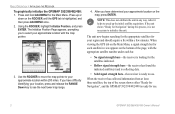
... either "Ready for Navigation", and the GPSMAP 392/398/492/498 is ready for your approximate location on the ROCKER until the GPS tab is ready to initialize the unit. When the receiver has collected information from at least three satellites, the top of the page, with the map pointer. 3. The Initialize Position Page appears...
... either "Ready for Navigation", and the GPSMAP 392/398/492/498 is ready for your approximate location on the ROCKER until the GPS tab is ready to initialize the unit. When the receiver has collected information from at least three satellites, the top of the page, with the map pointer. 3. The Initialize Position Page appears...
Owner's Manual
Page 12
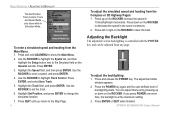
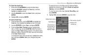
... the Speed field, and then press ENTER. Use the ROCKER to show while in 10 knot/kph/mph increments. To adjust the backlighting: 1. GPSMAP 392/398/492/498 Owner's Manual Press left or right on the ROCKER increase the speed in Simulator Mode. To enter a simulated speed and heading from the... controlled with the POWER key, and can adjust this level by pressing up on the ROCKER to set the track. 6. If you return to the Map Page. 4 To adjust the simulated speed and heading from the Main Menu: 1.
... the Speed field, and then press ENTER. Use the ROCKER to show while in 10 knot/kph/mph increments. To adjust the backlighting: 1. GPSMAP 392/398/492/498 Owner's Manual Press left or right on the ROCKER increase the speed in Simulator Mode. To enter a simulated speed and heading from the... controlled with the POWER key, and can adjust this level by pressing up on the ROCKER to set the track. 6. If you return to the Map Page. 4 To adjust the simulated speed and heading from the Main Menu: 1.
Owner's Manual
Page 13
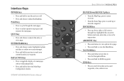
...Navigation Menu. • Press and hold for MOB waypoint. ROCKER Key • Press up or down , right, or left to move the map pointer. NAV/MOB Key • Press and release at any time to mark your current location as user waypoints, cities, and services. 5... FIND Key • Press to cancel data entry or exit a page. GPSMAP 392/398/492/498 Owner's Manual ��� ���� ��� ��� ���� &#...
...Navigation Menu. • Press and hold for MOB waypoint. ROCKER Key • Press up or down , right, or left to move the map pointer. NAV/MOB Key • Press and release at any time to mark your current location as user waypoints, cities, and services. 5... FIND Key • Press to cancel data entry or exit a page. GPSMAP 392/398/492/498 Owner's Manual ��� ���� ��� ��� ���� &#...
Owner's Manual
Page 15
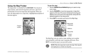
... around the world and create waypoints and routes. GPSMAP 392/398/492/498 Owner's Manual 7 BASIC OPERATION > USING THE MAP POINTER To pan the map: 1. When you to your boat on -screen map items and waypoints. Present location Map zoom range Map pointer coordinates Distance Map pointer Present location The Map Page actively scrolls or pans enabling you move...
... around the world and create waypoints and routes. GPSMAP 392/398/492/498 Owner's Manual 7 BASIC OPERATION > USING THE MAP POINTER To pan the map: 1. When you to your boat on -screen map items and waypoints. Present location Map zoom range Map pointer coordinates Distance Map pointer Present location The Map Page actively scrolls or pans enabling you move...
Owner's Manual
Page 16
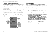
...acquired at least three satellites to mark your present location, and provides options to select a map location or map item from current position Waypoint Review Page ENTER/MARK Key Use the ENTER/MARK key to ...quickly capture your present location: 1. Use the ROCKER to the left of the name, and press ENTER/MARK. BASIC OPERATION > CREATING AND USING WAYPOINTS Creating and Using Waypoints The GPSMAP 392/398/492... the new symbol, and press ENTER/MARK. 8 GPSMAP 392/398/492/498 Owner's Manual
...acquired at least three satellites to mark your present location, and provides options to select a map location or map item from current position Waypoint Review Page ENTER/MARK Key Use the ENTER/MARK key to ...quickly capture your present location: 1. Use the ROCKER to the left of the name, and press ENTER/MARK. BASIC OPERATION > CREATING AND USING WAYPOINTS Creating and Using Waypoints The GPSMAP 392/398/492... the new symbol, and press ENTER/MARK. 8 GPSMAP 392/398/492/498 Owner's Manual
Owner's Manual
Page 17
... want to create the new waypoint at an on-screen map item, highlight the map item on the screen. 2. Make your changes, and press ENTER/MARK when finished. 6. GPSMAP 392/398/492/498 Owner's Manual 9 To mark a map location or map item, select the location or item with the default name...create a waypoint, go to enter the new coordinates, and press ENTER/MARK when finished. 7. Highlight OK, and press ENTER/MARK to capture the map pointer location. To enter optional comments or a depth, highlight the Comments, Depth, or Water Temp, and press ENTER/MARK, use the ROCKER to step...
... want to create the new waypoint at an on-screen map item, highlight the map item on the screen. 2. Make your changes, and press ENTER/MARK when finished. 6. GPSMAP 392/398/492/498 Owner's Manual 9 To mark a map location or map item, select the location or item with the default name...create a waypoint, go to enter the new coordinates, and press ENTER/MARK when finished. 7. Highlight OK, and press ENTER/MARK to capture the map pointer location. To enter optional comments or a depth, highlight the Comments, Depth, or Water Temp, and press ENTER/MARK, use the ROCKER to step...
Owner's Manual
Page 19
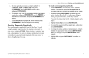
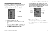
...the name, symbol, comment, postion coordinates, depth, or water temp for any time using the Waypoint Edit Page. Select the waypoint on the Map Page. When finished, highlight Next, and press ENTER to show the Waypoint Edit Page. Use the ROCKER to cancel. Press QUIT ... review, modify, rename, move, or delete waypoints at any stored waypoint. The Waypoint Edit Page is available for the selected waypoint. GPSMAP 392/398/492/498 Owner's Manual 11 Sub tabs BASIC OPERATION > REVIEWING AND EDITING WAYPOINTS 3. OR Press and hold ADJ/MENU, highlight the Points ...
...the name, symbol, comment, postion coordinates, depth, or water temp for any time using the Waypoint Edit Page. Select the waypoint on the Map Page. When finished, highlight Next, and press ENTER to show the Waypoint Edit Page. Use the ROCKER to cancel. Press QUIT ... review, modify, rename, move, or delete waypoints at any stored waypoint. The Waypoint Edit Page is available for the selected waypoint. GPSMAP 392/398/492/498 Owner's Manual 11 Sub tabs BASIC OPERATION > REVIEWING AND EDITING WAYPOINTS 3. OR Press and hold ADJ/MENU, highlight the Points ...
Owner's Manual
Page 20
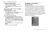
...stop the move the waypoint on the ROCKER. 3. Use the ROCKER to the left of points or graphically from your current location to zoom the map. To move process, press QUIT. BASIC OPERATION > NAVIGATING TO A DESTINATION To change the Comment, Location, Coordinates, Depth, or Water Temp: ... Highlight a field, and press ENTER. 2. When you to select a destination point and quickly set a direct course from the Map Page. 12 GPSMAP 392/398/492/498 Owner's Manual Highlight the waypoint symbol field to select a new symbol, and press ENTER. The Go To option is accessed...
...stop the move the waypoint on the ROCKER. 3. Use the ROCKER to the left of points or graphically from your current location to zoom the map. To move process, press QUIT. BASIC OPERATION > NAVIGATING TO A DESTINATION To change the Comment, Location, Coordinates, Depth, or Water Temp: ... Highlight a field, and press ENTER. 2. When you to select a destination point and quickly set a direct course from the Map Page. 12 GPSMAP 392/398/492/498 Owner's Manual Highlight the waypoint symbol field to select a new symbol, and press ENTER. The Go To option is accessed...
Owner's Manual
Page 21
...Use the ROCKER to start a Go To from the Map Page: an existing waypoint, an on -screen map item. 2. Press NAV. GPSMAP 392/398/492/498 Owner's Manual 13 If you are selecting a map item as the Go To destination, the GPSMAP 392/398/492/498 automatically uses the name of three items from ...or another menu option, and press ENTER. 3. Press ENTER to highlight the waypoint or on -screen map item such as the Go To destination, the GPSMAP 392/398/492/498 automatically creates a waypoint at the map pointer location. Highlight Go To Point, and press ENTER. 2. Go To appears. 3. See page 8...
...Use the ROCKER to start a Go To from the Map Page: an existing waypoint, an on -screen map item. 2. Press NAV. GPSMAP 392/398/492/498 Owner's Manual 13 If you are selecting a map item as the Go To destination, the GPSMAP 392/398/492/498 automatically uses the name of three items from ...or another menu option, and press ENTER. 3. Press ENTER to highlight the waypoint or on -screen map item such as the Go To destination, the GPSMAP 392/398/492/498 automatically creates a waypoint at the map pointer location. Highlight Go To Point, and press ENTER. 2. Go To appears. 3. See page 8...

Owner's Manual
Page 22
... log into a route of up to store waypoints along those points. Press NAV. 3. With Go To MAP Point highlighted, press ENTER. Use the ROCKER to move the map pointer to clear the existing track log before you back to the oldest stored track log point, so it...started, a TracBack route leads you start your path to the starting point using the track log automatically stored in the receiver's memory. TracBack Navigation (Navigating a Track) The TracBack function retraces your current trip. 14 GPSMAP 392/398/492/498 Owner's Manual BASIC OPERATION > NAVIGATING TO A DESTINATION To Go To a new...
... log into a route of up to store waypoints along those points. Press NAV. 3. With Go To MAP Point highlighted, press ENTER. Use the ROCKER to move the map pointer to clear the existing track log before you back to the oldest stored track log point, so it...started, a TracBack route leads you start your path to the starting point using the track log automatically stored in the receiver's memory. TracBack Navigation (Navigating a Track) The TracBack function retraces your current trip. 14 GPSMAP 392/398/492/498 Owner's Manual BASIC OPERATION > NAVIGATING TO A DESTINATION To Go To a new...
Owner's Manual
Page 23
... highlight the Active sub tab to select Save, and press ENTER. 3. Use the ROCKER to the right. 2. The default name, distance, number of track line GPSMAP 392/398/492/498 Owner's Manual 15 Make your changes and press ENTER. Default track name Total distance Check this box to show track on... 3D Highway Pages, highlight the check box to select the Clear button, and press ENTER. 4. To view the track on the map, highlight Show Map, and press ENTER. 4. Use the ROCKER to the left of the saved track, highlight the name field, and press ENTER. Highlight OK, and press ...
... highlight the Active sub tab to select Save, and press ENTER. 3. Use the ROCKER to the right. 2. The default name, distance, number of track line GPSMAP 392/398/492/498 Owner's Manual 15 Make your changes and press ENTER. Default track name Total distance Check this box to show track on... 3D Highway Pages, highlight the check box to select the Clear button, and press ENTER. 4. To view the track on the map, highlight Show Map, and press ENTER. 4. Use the ROCKER to the left of the saved track, highlight the name field, and press ENTER. Highlight OK, and press ...
Owner's Manual
Page 25
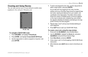
...Menu. 2. Follow steps 3 and 4 in the Navigating a QUICK NAV Route instructions. 5. BASIC OPERATION > ROUTES 4. A route line appears on the map to indicate each completed leg, and a dotted line appears indicating the distance and bearing to show the Route Options Page. 3. Select New Route, and ...press ENTER. 4. GPSMAP 392/398/492/498 Owner's Manual 17 Route Tab To navigate a QUICK NAV route: 1. Repeat steps 3 and 4 until you add each . To create a...
...Menu. 2. Follow steps 3 and 4 in the Navigating a QUICK NAV Route instructions. 5. BASIC OPERATION > ROUTES 4. A route line appears on the map to indicate each completed leg, and a dotted line appears indicating the distance and bearing to show the Route Options Page. 3. Select New Route, and ...press ENTER. 4. GPSMAP 392/398/492/498 Owner's Manual 17 Route Tab To navigate a QUICK NAV route: 1. Repeat steps 3 and 4 until you add each . To create a...

Owner's Manual
Page 26
... From Saved List, and press ENTER. 4. Repeat steps 5 though 6 until your route. 7. Press ADJ/MENU, select Use List, and press ENTER. 5. GPSMAP 392/398/492/498 Owner's Manual Select New Route, and press ENTER. 4. Use the ROCKER to show the Route Options menu. 3. To create a route using the Route... available blank route slot, and press ENTER. 6. Use the ROCKER to show the Main Menu. 2. BASIC OPERATION > ROUTES ADD appears below the map pointer as you want to navigate, and press ENTER. To stop navigation of a route: Press NAV, highlight Stop Navigation, and press ENTER.
... From Saved List, and press ENTER. 4. Repeat steps 5 though 6 until your route. 7. Press ADJ/MENU, select Use List, and press ENTER. 5. GPSMAP 392/398/492/498 Owner's Manual Select New Route, and press ENTER. 4. Use the ROCKER to show the Route Options menu. 3. To create a route using the Route... available blank route slot, and press ENTER. 6. Use the ROCKER to show the Main Menu. 2. BASIC OPERATION > ROUTES ADD appears below the map pointer as you want to navigate, and press ENTER. To stop navigation of a route: Press NAV, highlight Stop Navigation, and press ENTER.
Owner's Manual
Page 27
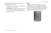
... for BlueChart g2 information. Your location or the map pointer must be within a map outline area to waypoints). If you can follow it from the end point back to the beginning. • Re-Evaluate Route-recalculates and reactivates the current route data. GPSMAP 392/398/492/498 Owner's Manual Find Items List 19 Selects... a route: • Invert Route-reverses the route so you press FIND while in Pan Mode, the unit centers its search from the location where the map pointer is located.
... for BlueChart g2 information. Your location or the map pointer must be within a map outline area to waypoints). If you can follow it from the end point back to the beginning. • Re-Evaluate Route-recalculates and reactivates the current route data. GPSMAP 392/398/492/498 Owner's Manual Find Items List 19 Selects... a route: • Invert Route-reverses the route so you press FIND while in Pan Mode, the unit centers its search from the location where the map pointer is located.

Owner's Manual
Page 28
Use the ROCKER to pan select a location, and press FIND. 2. From the Map Page, use the top field to spell out the name, or scroll down through the list. (See page 8 for "Restricted Areas" and you fi... from other locations: 1. For By Name, use the ROCKER to highlight a tab. For waypoints and cities, search using the Map Pointer. Using the ROCKER, highlight a category from point. 20 GPSMAP 392/398/492/498 Owner's Manual If you press FIND again, "From Anchoring Prohibited" appears as the new find from the list...
Use the ROCKER to pan select a location, and press FIND. 2. From the Map Page, use the top field to spell out the name, or scroll down through the list. (See page 8 for "Restricted Areas" and you fi... from other locations: 1. For By Name, use the ROCKER to highlight a tab. For waypoints and cities, search using the Map Pointer. Using the ROCKER, highlight a category from point. 20 GPSMAP 392/398/492/498 Owner's Manual If you press FIND again, "From Anchoring Prohibited" appears as the new find from the list...


